Showing 186 items
matching township planning
-
 Greensborough Historical Society
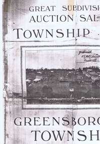
Plan, Greensborough Township Estate, 01/09/1923
... . Auction 1 September 1923 subdivision plans greensborough township ...Sub-division into 129 lots of land belonging to the Scotland Family, bounded by William Street, Eliza Street, James (Jessop) Street and south of Lorimer Street. Auction 1 September 1923Photocopy, double-sidedsubdivision plans, greensborough township estate, scotland family -
 Kiewa Valley Historical Society
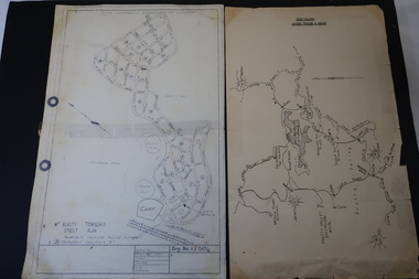
Maps - Bogong High Plains & Mt Beauty Township
The SECV continually updated their mapsDuring the development of the KHES the SECV had to continually update their mapsBoth Foolscap 1. Titled: High Plains Access Tracks & Roads 2. Mt Beauty Street Plan by SECV with Section Nos. and house numbersBoth have sticky tape marks on their back.khes maps -
 Kiewa Valley Historical Society
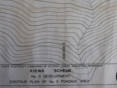
Plans - Kiewa Works Area and Environs
State Electricity Commission of Victoria constructed the Kiewa Hydro Electric Scheme from the late 1940s to 1961. These plans were used during the construction.Plans and Maps were used during the construction of the Kiewa Hydro Electric SchemeTransparent with blue tinge plans/maps created by the SECV during the construction of the Kiewa Hydro Electric Scheme. 1. Kiewa Scheme No 5 Development Contour Plan of No 5 Pondage Area 2. Mt Beauty Township 3. Kiewa Scheme No 1 Development - McKay Creek Area, Construction Layout 4. Kiewa Works and Environs 5. North Eastern Victoria and Adjoining Snowy Mountains Regionsecv, kiewa hydro electric scheme plans -
 Kiewa Valley Historical Society
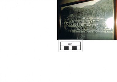
Photograph Bogong, Bogong Township Circa 1950, circa 1940s to 1950s
The Bogong Village was originally constructed (1937-1940) by the State Electricity Commission to house, engineers and construction workers working on the Kiewa Hydroelectric Scheme. These workers were initially settled in 26 houses and were mainly of European heritage. At the completion of the scheme, in the 1960's, the village was opened to public/tourism use. This photograph shows the village before beautification for tourism was introduced and "bare bones" homes and village usage existed.This photo clearly presents a period of restricted human occupation of a very fragile Alpine environment(up to 4000 workmen involved). This was the beginning of a planned and controlled form of sustainable tourist orientated development of the Victorian Alps and high plains region. The Bogong Township was the base camp for workers employed by the State Electricity Commission. After the construction phase was completed, the planning and controls originating from this period have been modified to allow a greater public access of this unique environment.Photograph of a framed glass enclosed black and white photograph of the Bogong settlement Paper details "KodakXtraLife paper" on back of photo. bogong village, bogong township, sec alpine constructions, hydro, kiewa scheme -
 Eltham District Historical Society Inc
Photograph, George W. Bell, Diamond Creek, 1969, 1969
Canberra Times (ACT : 1926 - 1995), Thursday 9 January 1969, page 1 A day of century heat, 13 KILLED IN VICTORIAN FIRES ...About thirty houses and a public hall were destroyed by fire in the township of Diamond Creek. The group officer of the Diamond Creek Fire Brigade, Mr Tom Harrington, said tonight that he thought it was a "miracle" that no-one lost their lives in the fires. A relief centre for the homeless was set up by the Diamond Valley Shire Council. Mr Harrington said that the first fire call in the town was received at 10.45 am. "Within 20 minutes there were five more fires and it seemed like the whole town was alight", he said. "It was a chaotic day. All our best plans for fighting the fires became disorganised. "As 60-mile-an-hour winds swept fires through different parts of the town many fire fighters were unable to get from one fire to another. ," Black and white photograph of charred fire remnant Diamond Creek 1969diamond creek, fire, george w bell collection, bushfire, charred, burnt timber -
 Warrnambool and District Historical Society Inc.
Book, Description & plans of title & grants
This book contains certificates of title and Crown grants which record local changes of ownership.many are in the township of Warrnambool while others relate to areas such as Nullawarre, Purnim and Framlingham. These documents come under the Transfer of lands act of 1890.The significance of this book lies in the many names and the land to which they were connected. Deep maroon paper over card cover with dark green fabric binding.Alphabetical index at the front followed by 200 pages which record details of the Certificates of title and Crown Grants from around the period of warrnambool, warrnambool history, certificate of title, crown grant warrnambool -
 Ringwood and District Historical Society
Map, Department of Mines, Plan of area applied for under the mining leases regulations in the township of Ringwood between Maroondah Highway and Mt. Dandenong Road. Mining District of Castlemaine, County of Mornington, Parish of Ringwood T Area 58(A) 2 (R)15(P) Acres, Roods, Perches. 1934, 20-Feb-34
Map of the township of Ringwood with subdivisions between Maroondah Highway and Mt. Dandenong Road. the area applied for on lease No.8210 by E.G.Browne.Mining District of Castlemaine, County of Mornington, Parish of Ringwood T Area 58(A) 2 (R)15(P) Acres, Roods, Perches.Buff coloured sheet foolscap with black printing showing map of the township of Ringwood between Maroondah Highway and Mt. Dandenong Road. Mining District of Castlemaine, County of Mornington, Parish of Ringwood T Area 58(A) 2 (R)15(P) Acres, Roods, Perches +Additional Keywords: Browne E.G. -
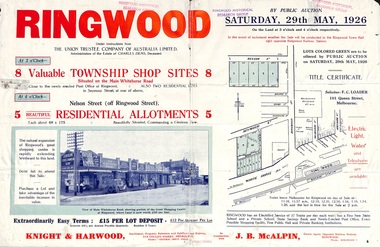 Ringwood and District Historical Society
Flyer, Township Shop Sites and Residential Allotments Sale By Public Auction, Ringwood, Victoria - 1926
Advertisement for eight township shop sites and five residential allotments for sale by Public Auction on the land in Ringwood on Saturday, 29th May, 1926, with location map, and summary of local features and services. Locality plan highlights sites for auction in Nelson Street, Seymour Street and Whitehorse Road. (Agents) Knight & Harwood, 315 Collins Street, Melbourne, Phones 10615, 10616 Central, in conjunction with J.B. McAlpin, Estate Agent, Opposite Railway Station, Ringwood, Phone Ringwood 7. -
 Ringwood and District Historical Society
Flyer, Land Sale Advertisement - East Ringwood Township Estates, East Ringwood, Victoria - circa 1920
The date of the flyer as circa 1920 can be estimated from the references to the (decision on) "electrification of the Croydon Railway Line" which eventually occurred in 1923, letting of tenders for the state school building which opened in 1924, and the "proposed new railway station" (East Ringwood) which opened in 1925, Advertisement for three retail and residential allotment land sales in East Ringwood Township including maps showing layout of subdivisions. Township Estate, State School Estate, and East Ringwood Station Estate.Subdivision plans include Mount Dandenong Road, Grey Street, Eastfield Road, King Street, Everard Road, Holland Road, Purser Avenue, and Charles Street. (Agents) Spencer Jackson, Subdivider & Homebuilder, 341 Collins Street, Melbourne, Phones: M2327 (3 lines), also at Dromana, Phone 65. -
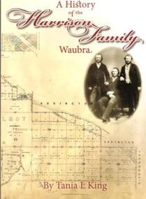 Learmonth and District Historical Society Inc.
Book, Tania.L.King. et al, A History of the Harrison Family,Waubra,by Tania.L.King, october 2012
This book gives the history of the Harrison Family of Waubra - celebrating 160 years in Australia from 1852-2012.The Harrison family came originaly from Catterick and later Langthorne,North Yorkshire.England.Recording the Family Tree of the Harrison Family of Waubra,Victoria.Cover of book is Beige in colour,with the title and authors name in maroon.On the right under the title is a photo of James Harrison with his two sons William and Christopher .The bottom of the cover shows the title plan of Ercildoun,sheet 2,courtsey State of Victoria.The back cover photograph is of Waubra township.A History of the Harrison Family,Waubra.by Tania.L.King.harrison family 1852 - 2012, waubra victoria, tania l king, catterick north yorkshire england, -
 Federation University Historical Collection
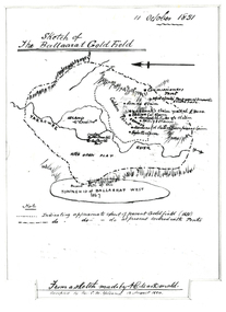
Plan, Sketch of Ballaarat Gold-Field, 1851, 11/10/1851
The sketch was made by A.C. MacDonald, F.R.G.S. and presented to James Oddie, who was one of the earliest gold diggers at Ballarat..1) Reproduction of a line sketch plan of the Ballarat goldfield as it was on 11 October 1851 as drawn by A.C. MacDonald, and recopied by C.M. Yelland. The dots indicate appoximate extent of the Ballarat Goldfield in 1851. The dot and dash line indicates approximate area covered with tents. .2) Includes an indication of the locality of the Township of Baallarat West in 1867. Verso of cat. No. 4296.2, and written by Keith Rash - "On 10th October 1851, 1,300 licenses had been issued. 30th October 1851 2246 licenses. Lieut. Gov. LaTobe letter to Earl Grey." james oddie, a c macdonald, gold commissioner, mcleod, alfred clark, kavanagh, willis, highett, yarrowee river, a.c. macdonald, ballarat goldfield, ballaarat goldfield, lamda, c.m. yelland -
 Federation University Historical Collection
book, Truth & Sportsman Ltd, Souvenir commemorating the commencement of work by the Snowy mountains hydro-electric authority, 17/10/1949
It is assumed that a member of the Ballarat School of Mines attended the commencement of work at the Snowy Mountains hydro-electric centre.Burgundy cover with gold printing. Black print, photos and diagrams on white paper (31 pages). Bound by 3 staples. The contents include the story of the Snowy. Images include W.J. McKell, J.B. (Ben) Chifley, J. McGirr, Nelson Lemmon, Hume Weir, Jindabyne valley (now flooded), Jindabyne township (now flooded), illustration of water Power, survey team at Adaminaby, Snowy Mountains Relief Plan, Horseman crossing the Eucumbene River, Mildura, Burrinjuck Dam under construction, transmission lines, W. Hudson.snowy mountains hydro-electricty scheme, snowy mountains hydro-electric authority -
 Federation University Historical Collection
Book, Memoirs of the Geological Survey of Victoria No 14 The Ballarat Goldfields, 1923, 1923
William Baragwanath was educated at the Ballarat School of Mines, obtaining a Geology Certificate in 1911. After further study he went on the become Secretary for Mines, and Chief Mining Surveyor. Baragwanath was a Councillor of the Ballarat School of Mine from 1916 to 1950.Pink covered foolscap book of 257 pages and 32 maps and plans by William Baragwanath. Contents include topography, physiography, historical, geology, basalt, faults, dykes, minerals leads, alluvial mines, nuggets, structure of Ballarat West goldfields, structure of Ballarat East gold-field, quartz formation, indicators, defunct mines, existing mines, table of deepest shafts. Images include: section of the Ballarat Gold-Field, Dead HOrse Flat, lakes formed by Basalt Flows, Gong Gong Creek, Frenchman's Lead, Ballarat West Mines, LEases and positions of shafts (1857), puddling, White Horse Lead, Woah Hawp Canton, Ballarat Township mines, Sebastopol, syncline, Victoria United Line, First Chance Mine, Llanberris No 1 Mine, Saddle Reef, New Normanby Mine, Woah Hawp Canton Mine, South Star Mine, Sebastopol Plateau, south Woah Hawp Mine, Woah No. 2 Minegeology, geological survey no 14, ballarat, baragwanath, william baragwanath -
 Federation University Historical Collection
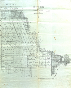
Map, Doroq County of Grenville L4935, 1911, 28 June 1911
This plan is associated with former Ballarat School of Mines Student Richard Squire (1875-1876). Gift of the Squire FamilyParish Plan of Doroq in black ink printed on cream paper. It includes the township of Inverleigh and Barwon Rover. Some of the names on the plan are William McRobie, William MacRobie, Thomas Russell, W.C. Smith, John Bell, J. Moffatt, Thomas Moffatt, John Anderson, George Synnot, Charles Lloyd, William MacRobie, J. Flack, Alexander Campell, T. Maher, William Berthon. Thomas Jewell, James Carstairs, D. MCInnerney, F.H. Holland, Robert Morrison17 7/9 18 9 miles handwritten in pencil Photo lithographed at the Department of Lands and Survey Melbourne by T. E. McGauran 28.6.11 Price 1/-carrunge-murnong, murdeduke, carrah, shelford, inverleigh, barwon river, hesse, wingeel, george russell, george russell's pre-emptive section, john moffatt, w. c. smith, macrobie, john bell, thomas russell, t.f. mcgauran -
 Federation University Historical Collection
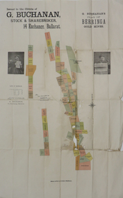
Plan, G. Buchanan's Plan of the Berringa Gold Mines, 1866?
This plan is associated with former Ballarat School of Mines student Richard Squire (1875-1876) Gift of the Squire FamilyColoured plan of the Berringa Goldmines.squire, richard squire, berringa, g. buchanan, buchanan, stockbroker, birthday freehold, f. holst, holst, staffordshire reef, williams fancy, kangaroo, moonlight, cgt, staffordshire reef township, w. prie, northern birthday, a clinton, birthday star, a. lamb -
 Federation University Historical Collection
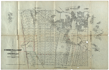
Plan, Commeralghip, County of Grenville, 1905, 03/02/1905
... , Victoria. The plan includes the township of Kaleno, Dereel Pre... The Township of Kaleno is in the Pitfield Plains. The Cape Clear ...The Township of Kaleno is in the Pitfield Plains. The Cape Clear Cemetery T contains the graves of miners and local pioneering families from the Cape Clear, Hollybush, Kaleno, Pitfield Plains, Pitfield, Illabarook, Berringa, Springdallah, Wallinduc, Glenfine, Happy Valley and Western Creek districts.Plan of allotments in Commeralghip, County of Grenville, Victoria. The plan includes the township of Kaleno, Dereel Pre-Emptice Right (John Cullen), Commeralghip Pre-Emptive Right (John Gordon McMillan and Glenfine Pre-Emptive Right (William Rowe). It also includes landholders such as Robert mcPherson, C. Cameron. John Boyd, John Cullen, W.T. Rowe, George Currie, J.P. Mackay, T. McCaffery, G. Hawkins, Alexander McPherson, C. Cameron. Gift of the Squire Family, 2014commeralghip, pitfield plains, kaleno, dereel, glenfine, squire, richard squire, w.t. rowe, john cullen, alexander mcpherson, george currie, mt misery, william rowe, mindai, john gordon mcmillan -
 Federation University Historical Collection
Booklet, GIAE Official Opening, 1976, 11/1976
The Gippsland Institute of Advanced Education was established by an Order-in-Council in September 1968. On its establishment, the Institute assumed responsibility for the diploma coursed previously offered at Yallourn Technical College. In 1972 the Institute transferred part of its operations to the first of its permanent buildings on a large campus in rural surrounding near the township of Churchill, ten kilometres south of Morwell, and 160 kilometres east of Melbourne. The campus site plan report prepared in 1970 by the Institute's campus planners, Yuncken Freeman Architects Pty Ltd, provided the conceptual base for the development of a new campus at Churchill. All facilities were planned to converge on a central space; all having the ability to expand outwards. Central to the campus plan was the concept of an internal pedestrian street connecting all academic divisions to the central facilities. The first building was completed in 1972. The Administration Building, Visual Art & Maintenance Workshops, Multi-Purpose Building, and Student residences were designed by Yuncken Freeman Architects. The central Facilities Building (cafeteria and Union) were designed by Chancellor and Patrick, the Education Building and Applied Science Building is designed by Eggleston, McDonald and Secomb.Grey and yellow soft covered booklet prepared for the official opening of Gippsland Institute of Advanced Education.gippsland institute of advanced education, gippsland campus, churchill, m.w. hopper, c.h. ford, lindsay thompson, j.l. carrick, r.w. muncey -
 Federation University Historical Collection
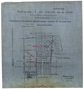
Plan, Plan applied for a Lease, Parishes of Glenmora and Rothcar, 27/05/1913
Plan on linen showing mining leases around the township of Lower Homebush, District of Maryborough. Scale: 20 chains to in inch (1:15840) WGS 84 Centroid Lat: 37 degrees 01 feet 35 inches S Long: 143 degrees 30 feet 35 inches S NS: 3.2km EW: 2.8km glenmona, rathcar, gladstone, maryborough, mining, clarence smith, homebush, clarence smith, w d thompson, peter leyden, b elliot, c horne, a field, john leydon, g jolly, r e jolly, d garner, s j barry, m harris, a harris, w j mcconnell, ellen harris, r j harris, j barry, t curtain, s garner, e barry, m j barry, l e squires, wilkins jnr, e c grace, e j field, mary field, m broughton, b l lusby, m j lusby, j e field, f broughton, j gillock, m simmons, glenmona, rathscar, parish of avoca, maryborough district, albert field, g grose, j harris -
 Federation University Historical Collection
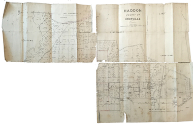
Plan, Haddon County of Grenville, 1887, 1887
Parish Plan of Haddon showing the township of Haddon, Cardigan and Haddon State Forest, Lake Burrumbeet and Nentingbook Pre-emptive Right. Names on the allotments include H. Cuthbert, B. Hepburn, T.W. Lloyd, J. Palmer, E.A. Wynne, William Collard Smith, A. Porteous, P. Russell, J. Mitchell, G. Renniehandwritten 'J. H. Cunningham Applic'haddon, cardigan, haddon state forest, lake burrumbeet, nentingbook pre-emptive right, h. cuthbert, b. hepburn, t.w. lloyd, j. palmer, e.a. wynne, william collard smith, a. porteous, p. russell, j. mitchell, g. rennie, j. noone, department of lands and survey -
 Federation University Historical Collection
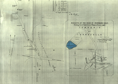
Plan, A.M. Howitt, Nuggets at the Head of Ironbark Gully, Tarnagulla, c1907
Plan showing part of the township of Tarnagulla, and the Ironbark Gully area including Western Reef and Creek's Hill.tarnagulla, ironbark gully, western reef, creek's hill, cgt -
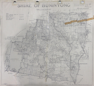 Federation University Historical Collection
Map, Shire of Buninyong, c1970
The Shire of Buninyong was located on the southern side of Ballarat.Two maps of the Shire of Buninyong. .1) Map showing the County divisions, township boundaries, Railway line, State Forest boundary, riding boundary and shire boundary. Identifying words have been added in red and green texta. .2) Shire of Buninyong Parish Plan. Includes Buninyong, Clarendon, Narmbool, Enfield, Lychfield, SCotchman's, Navigators, Warrenheip, Scotsburn, mr Doran, Durham Lead, Cambrian Hill, Napoleons, Garibaldi, Mt Clear, Lal Lal, Bonshaw.1) B.I.A.E., St Martin's, cemetery, mt Buninyong, mt Innes, rly stn shire of buninyong, buninyong, clarendon, narmbool, enfield, lychfield, scotchman's, navigators, warrenheip, scotsburn, mt doran, durham lead, cambrian hill, napoleons, garibaldi, mt clear, lal lal, bonshaw, state forest, elaine, elaine north, cargerie, grenville, mt mercer, millbrook, wallace, yendon, canadian, kaolin deposits, mount helen campus -
 Bendigo Historical Society Inc.
Document - H.A. & S.R. WILKINSON COLLECTION: CONTRACT OF SALE
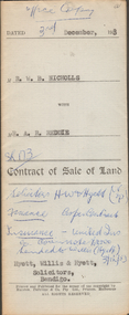
Contract of sale of land dated 3rd December, 1953 between Mr. W.B. Nicholls (seller) and Mr. A.R. Reddie (buyer) for that piece of land that lies above the depth of 50 feet below the surface of lot 12 on plan of subdivision lodged at the office of titles in red ink No. 5394259 dated 19/1/1953 and being part of allotment 12 section 10 township Kangaroo Flat, together with all improvements thereon. Price 2,850 pounds.organization, business, h.a. & s.r wilkinson real estate -
 Bendigo Historical Society Inc.
Document - H.A. & S.R. WILKINSON COLLECTION: CONDITION OF SALE
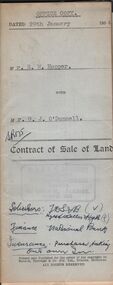
Contract of sale of land dated 29th January 1954 between Mr. E.M. Hopper (seller) and Mr. G.J. O'Donnell (buyer) for land being Lot 2 on plan of subdivision No. 23332 registered in the office of titles, Melbourne and situate in Lindsay Street Kangaroo Flat part of Crown allotment 11 section 23, township of Kangaroo Falt described in Certificate of title volume 7446 folio 423, together with weatherboard dwelling, wood shed-lavatory also fencing on the said land. Price 2,700 pounds.organization, business, h.a. & s.r wilkinson real estate -
Bendigo Historical Society Inc.
Map - CAMPBELL COLLECTION: BENDIGO AND DISTRICT MAPS, 8-7-29
Map. Rifle Range, Parishes of Wellsford and Sandhurst. Scale 20 chains to 1 inch. Total area by Planimeter 5916 acres. Wallan and Bendigo Railway line. Rifle Range. Axedale township and station 8 miles. To Longlea Ryl station 2 1/2 miles. To Epsom 1 1/2 miles. To Bendigo 3 miles. Compiled in W.P.D. from Assessment and Parish Plans by H.A.D 8-7- 29 (number 367 in map cupboard 1)H.A.D.(H.A.Darby)map, bendigo, allotments -
 Bendigo Historical Society Inc.
Document - H. A. & S. R. WILKINSON COLLECTION: CONTRACT OF SALE
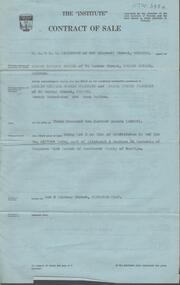
Contract of sale dated 23rd August, 1957 between Mr. E. M. Hope (vendor) and Mr. L. W. & Mrs G. E. Pearmain. Solicitor for vendor: Tatchell, Dunlop, Smalley & Balmer, Williamson Street Bendigo. Solicitor for purchaser: Tatchell, Dunlop, Smalley & Balmer, Williamson Street, Bendigo. Property: Lot 5 Lindsay Street, Kangaroo Flat being lot 5 on plan of subdivision in red ink no. A167046 part of allotment 4 section 23 township of Kangaroo Flat. Price 3,200 pounds. Attached Statement pursuant to section 34 of the estate agents act 1956 and Engagement or appointment in writing pursuant to section 33 of the estate agents act 1956.organization, business, h.a. & s.r wilkinson real estate -
Bendigo Historical Society Inc.
Map - CAMPBELL COLLECTION: BENDIGO AND DISTRICT MAPS, 21-8-1972
Map. Shire of Strathfieldsaye Locality Plan. Scale 1 inch=1 mile. Drawn by M.Higgs 21-8-1972, Shire of Huntly, Shire of McIvor, City of Bendigo, Shire of Marong, Shire of Maldon, Shire of Metcalfe, Lake Eppalock, Axedale Township, Strathfieldsaye Township, Melbourne to Bendigo Railway Line, Big Hill Tunnel, Mt.Herbert 1596. (number 398 in map cupboard 1)M.Higgs 21-8-1972map, bendigo, locality plan -
Port Melbourne Historical & Preservation Society
Plan - Sandridge, Department of Lands and Survey, "The Township of Sandridge", 5 Nov 1860
... annotations added at unknown date. "The Township of Sandridge" Plan ...Map of Sandridge, lithographed 1860, showing subdivisions on Evans Street, but no other development West of the railway Lihographed at the Department of lands and Survey, Melbourne 5th November 1860. Hand drawn annotations added at unknown date.Hand written "clay ground" 18 chains long, 7.5 chains broad, 26 chains from railwayengineering - roads streets lanes and footpaths, sandridge lagoon, transport - railways, town planning, local government - borough of sandridge -
Port Melbourne Historical & Preservation Society
Plan, The Township of Sandridge, 30 Mar 1859
... Plan of the township of Sandridge.Lithographed... of sandridge Plan of the township of Sandridge.Lithographed ...Plan of the township of Sandridge.Lithographed at the Public Lands Office, Melbourne, March 30th 1859engineering - roads streets lanes and footpaths, municipal district of sandridge -
Port Melbourne Historical & Preservation Society
Plan, Department of Lands and Survey, The Township of Sandridge, 25 Nov 1860
... Plan of the township of Sandridge lithographed... of sandridge Plan of the township of Sandridge lithographed ...Plan of the township of Sandridge lithographed at the department of Lands and Survey, Melbourne 5th November, 1860. Identical to 1859 version except for added rail line through Sandridge and onto Town Pierengineering - roads streets lanes and footpaths, municipal district of sandridge -
Port Melbourne Historical & Preservation Society
Plan - Sandridge Township, 1860, 1860
... Plan of Sandridge Township 1860 (Latrobe Library)... of sandridge Nov. 1860 (on rear) Plan of Sandridge Township 1860 ...On back is handwritten - Nov 1860.Plan of Sandridge Township 1860 (Latrobe Library)Nov. 1860 (on rear)local government - municipal district of sandridge