Showing 75 items
matching victoria country roads board
-
 Whitehorse Historical Society Inc.
Document, Roads, 1/02/1937
... Victoria. Country Roads Board... of Blackburn and Mitcham Victoria. Country Roads Board Roads ...Claims by Shire of Blackburn and Mitcham for reimbursement from Country Roads board for amounts expended on the main Healesville (now Whitehorse) and Burwood Roads, February 1937.burwood highway, healesville road, shire of blackburn and mitcham, victoria. country roads board, roads and streets, whitehorse road, nunawading -
Whitehorse Historical Society Inc.
Document, Roads, 1/03/1937
... Victoria. Country Roads Board.... Country Roads Board Shire of Blackburn and Mitcham Whitehorse Road ...Claim by Shire of Blackburn and Mitcham for reimbursement from Country Roads Board for amounts expended on the Main Healesville Road (now Whitehorse Road), March 1937.healesville road, roads and streets, victoria. country roads board, shire of blackburn and mitcham, whitehorse road, nunawading -
 Whitehorse Historical Society Inc.
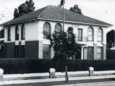
Photograph, Former Shire Offices, 1973
... victoria. country roads board... Mitcham melbourne Later used as Offices by Country Roads Board ...Later used as Offices by Country Roads BoardBlack and white photo of Municipal Office for the Shire of Blackburn and Mitcham, 360 Whitehorse Road, Nunawading. Later the City of Nunawading. - Sold to the Country Roads Board (C.R.B.), later known as Vicroads until sold in mid 1990s. Photo taken in 1973.shire of blackburn and mitcham chambers, victoria. country roads board, vicroads, whitehorse road, nunawading, no 360 -
 Whitehorse Historical Society Inc.
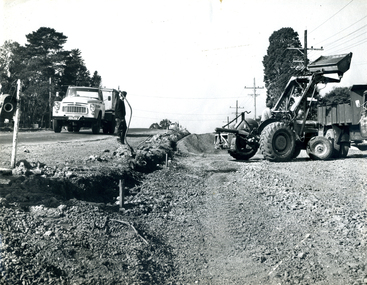
Photograph, Roadworks in Canterbury Road, Forest Hill
... victoria. country roads board... Mitcham melbourne canterbury road forest hill victoria. country ...Black and white photo of Roadworks in Canterbury Road, Forest Hill. east of Springvale Road in conjunction with C.R.B.canterbury road, forest hill, victoria. country roads board -
 Orbost & District Historical Society
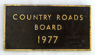
plaque, 1977
The Country Roads Board was the government authority for the construction and maintenance of main roads in Victoria between 1913 and 1983. It was succeeded by the Road Construction authority on 1 July 1983 and later merged with the Road Traffic Authority on July 1 1989 to form the Roads Corporation. James Cameron, an Orbost farming pioneer and Member of the Legislative Assembly, fathered the Country Roads Board. This plaque was possibly removed from a bridge(?) when the name was changed.A heavy rectangular shaped bronze plaque. the background is dark brown and the print and frame bronze coloured. On the back are two round recesses for screwing and attaching the plaque.COUNTRY ROADS BOARD 1977country-roads-board cameron-james -
 Orbost & District Historical Society
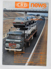
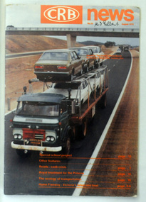
magazine, CRB News, August 1975
The Country Roads Board was the government authority for the construction and maintenance of main roads in Victoria between 1913 and 1983. It was succeeded by the Road Construction authority on 1 July 1983 and later merged with the Road Traffic Authority on July 1 1989 to form the Roads Corporation. James Cameron, an Orbost farming pioneer and Member of the Legislative Assembly, fathered the Country Roads Board.This item is a useful research source on the Princes Highway, Gippsland.A 19 pp magazine, titled CRB ( Country Roads Board) News. It is dated August 1976. On the front cover is a coloured photograph of a truck carrying cars. In the background is a road bridge. It contains an article on the Princes Highway, Gippsland.magazine journal-crb-news princes-highway -
 Orbost & District Historical Society
pamphlets, Princes Freeway - Orbost Section, 1976
Opened by the Hon. J A Rafferty, Minister for Transport, 25 November 1976, the bridge was the first of four bridges to be built as part of the freeway bypass of Orbost. Construction cost $2.4 million. This construction was an important development along the Princes Highway corridor through East Gippsland. The original highway approached the Snowy River at a very poor alignment, and several serious accidents had occurred at the Orbost end. In times of heavy flood, the highway on both sides of the river had been cut by floodwaters and during the 1971 floods, the highest ever recorded, the river was a mile wide at the crossing. Construction of the bridges commenced in January 1975, with an expectation to open the bridge across the Snowy River as soon as possible. Less than two years later, on 25 November 1976, the bridge across the Snowy River was opened to traffic, allowing the old bridge to be demolished. The remainder of the Orbost Bypass, both the floodplain crossings and the eastern section around the township itself, was declared ‘Princes Freeway’ and opened to traffic in December 1977. (ref http://mrv.ozroads.com.au) The Country Roads Board was the government authority for the construction and maintenance of main roads in Victoria between 1913 and 1983. It was succeeded by the Road Construction authority on 1 July 1983 and later merged with the Road Traffic Authority on July 1 1989 to form the Roads Corporation. James Cameron, an Orbost farming pioneer and Member of the Legislative Assembly, fathered the Country Roads Board. The opening of this Snowy River Bridge was an important development in the accessibility to the township of Orbost.Three coloured Country Roads pamphlets for the 'Princes Freeway - Orbost Section". On the front is a coloured photograph of the new construction over the Snowy River at Orbost. Inside is a program for a ceremony for the opening of the new Snowy River Bridge. There is also a black print map of the project. -
 Orbost & District Historical Society
black and white photograph, 1913
This photograph shows Country Roads Board men clearing a bush track at Hospital Creek. Their vehicle was bogged. The y Roads Board was formed in 1913 1910 it had become apparent that there was a need for a central roads authority to take over responsibility from the Board of Lands and Works for the care and management of the main roads of the state of Victoria. Because there was no consistent and systematic policy for road maintenance Victorian roads were in a deplorable condition. At this time the use of the motor car accentuated the demands for better roads. As a result of these needs the Country Roads Act 1912 was proclaimed in 1913 providing for the establishment of the Country Roads Board as a central road authority with responsibility for those roads within the State considered to be main roads. the C.R.B. was responsible for the construction of roads and bridges including the Snowy River road bridges in Orbost.. This is a pictorial record of transport difficulties in East Gippsland in early 20th century.A large black / white photograph of three men clearing a bush track with a motor vehicle behind them.transport roads road-maintenance country-roads-board -
Ringwood and District Historical Society
Plans - Freeway, Country Roads Board, Victoria, Eastern Freeway Ringwood Section - Planning Report on Suggested Concepts Investigation (Country Roads Board) 1974, 1974
... Country Roads Board, Victoria... Board) 1974 Plans - Freeway Country Roads Board, Victoria ...Report on suggested concepts investigation for freeway.Report on suggested concepts investigation for freeway. Buff coloured covers with brown printing. Bound with brown Spirex. pp. 39. -
Glen Eira Historical Society
Plan - Warrigal Road, Oakleigh
Documents about a small portion of land on Warrigal Road Oakleigh, now Oakleigh East. A Letter dated 29/05/1952 from Gas and Fuel Corporation of Victoria to Mr. L.P. Simmonds requesting valuation of land for proposed widening of Warrigal Road. A plan of Survey, no.5474, for Crown portion of Parish of Moorabbin and Parish of Mordialloc for owner The Brighton Gas Coy Ltd. New Street Brighton. Mortgages to the National Mutual Life Association. A letter dated 04/06/1952 from Gas and Fuel Corporation of Victoria in reference to Warrigal Road and Centre Road from the Country Roads Board who desire to acquire the land. Handwritten calculation notes and price for valuation, most likely as an attachment to the letter dated 04/06/1952.gas and fuel corporation, warrigal road, centre road, moorabbin council, simmonds l.p, survey plan, county of bourke, the brighton gas company ltd., country roads board, the national mutual life association of australia ltd., bentleigh east -
 Eltham District Historical Society Inc
Document - Series Listing, Fraser Faithfull et al, Series 67: Historical Register Volumes, 2000
Series consists of over 140 volumes of Council Records. These records (apart from the Rates Books) fall outside the provisions of the Victoria Public Record Office Disposal Schedule - ie. Retention is at the discretion of Council. A complete listing of the volumes is attached, however the collection includes Minute Books, Letter Books, Country Roads Board Ledgers, Finance Committee Finance Books, Water Supply Rate Books, and numerous cash books and ledgers. Consideration is currently being given to sending approximately half the collection to off-site storage (Ausdoc - Port Melbourne)shire of eltham archives, series listing -
 Phillip Island and District Historical Society Inc.
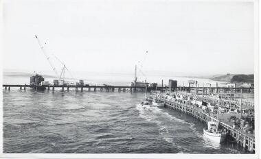
Photographs, Country Roads Board, Construction of 2nd Phillip Island Bridge 1966 - 1969, 1966 - 1969
... 351-01: Country Roads Board Victoria, Aust. Negative... bridge (1969) country roads board sasha stark 351-01: Country ...Collection of Black & White photographs of the construction of the second Phillip Island Bridge by the Country Roads Board. Contractor John Holland & Co Pty. Ltd.Black & White photographs of the Construction of the Phillip Island 2nd Bridge in 1969 351-01: View from centre of suspension bridge. 351-02: Concreting Pier 8 351-03: Concreting Pier 8 351-04,05 & 06: Metal beams. 351-07: Driving sheet Piling. 351-08:Reinforcement in caisson (watertight structure)351-01: Country Roads Board Victoria, Aust. Negative No. 67-37 - Phillip Island Bridge Project. Shire of Bass 352-02: As above - Negative No. 67-38B 352-03: As above - Negative No. 57-38D. 352-04: Negative No. 67-223A. 352-05: Negative No. 67-223B 352-06: Negative No. 67-223D 352-07: As 352-01-03 plus Negative No. 67-312 352-08: As above - Negative No. 67-272.phillip island bridge (1969), country roads board, sasha stark -
 Greensborough Historical Society
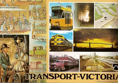
Book, Transport in Victoria, 1980s
Each of these booklets details the history, changes and upgrades to transport in Victoria in the early 1980s and explains the role af government authorities such as the Country Roads Board. Item 707c describes the Melbourne Freight Terminal between Spencer Street and Footscray Road.An historical look at the development of transport in Victoria.A collection of 3 booklets on transport in Victoria. Item 707a: 16 pages, colour illustrations. Item 707b: 20 pages, colour illustrations.Item 707c: 8 pages, black and white illustrations (20 x 14.5 cm). railways, transport, victoria, trams, roads -
 Warrnambool and District Historical Society Inc.
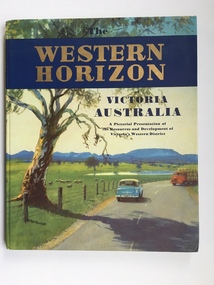
Book, Western Horizon, C 1960
This book presents a pictorial history of the western District of Victoria. It explores various aspects of the Western District such as water supply,architecture,ports,produce,and agriculture. It also presents the various scenic spots around the district. The publishers of this book , the Australian publicity Council is dedicated to publicising the state of Victoria and its natural resources in an effort to attract overseas investment and industry.This book provides a snapshot of the Western District in the 1960 's both with the information and the photographs contained within, including some which were taken by Ralph Illidge who was one on Warrnambool's best known photographers. Coloured hard board cover with country scene with road with two vehicles on a road which continues to the back cover.. A large gum tree sits beside the road. The title is gold on a navy blue banner. Thereis a small blurb on the back cover. 112 pages.Australian Publicity Council. Henry Bolte Premier of Victoria.history of warrnambool, western horizon, western victoria, ralph illidge, warrnambool 1960's -
 Warrnambool and District Historical Society Inc.
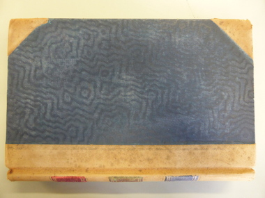
Document - Ledger: Correspondence and reports Country Roads Board , Shire of Warrnambool 1914-1925, Circa 1914
The letters contained within this ledger provide an overview of correspondence which occurred around matters such as roadmaking and maintenanceProvides a detailed record of correspondence relating to engineering matters in the shire and surrounds and also a comprehensive list of organisations associated with this work.Dark blue watermarked cover with fawn suede binding and corners. Spine has three coloured rectangles with the following in each: Correspondence and reports, Country Roads Board and Shire of Warrnambool. There is an index at the front and the ledger contains copies of correspondence relating to roads, maintenance and infrastructure.Inserted in ledger is1) typed invoice from The Government of Victoria to Shire of Warrnambool for 1915/16, 2) Original of two pages showing list of contracts on Garvoc Laang Road. Arnall and Jackson, Engravers and Lithographers. Printers and Manufacturing stationers 478 Collins Street, Melbourne. No B 22065 23/09/14. warrnambool, warrnambool shire engineer, shire correspondence, crawley, road works, bridges, bitumen roads, 1914-1925, country roads board -
 Orbost & District Historical Society
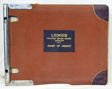
ledger, 1950's -1960's
This ledger was used bt the Shire of Orbost local government to record Country Roads Board accounts 1950's and 1960's. The item was donated to Orbost & District Historical society from P.R.O.V. as a Place of Deposit (POD) item for safe keeping by a local history group or museum. The shire covered an area of 9,347 square kilometres and existed from 1892 until 1994 when it became part of the East Gippsland Shire Council. Orbost was at first included in the Bairnsdale Shire from 1882 and was later part of the Tambo Shire. Because of travelling distances the Croajingalong Shire was created in 1892 (name changed to Orbost Shire 17.2.1893 with James Cameron as the first Shire President. In 1994 it amalgamated to become part of East Gippsland Shire Council. The Country Roads Board was the government authority for the construction and maintenance of main roads in Victoria between 1913 and 1983. It was succeeded by the Road Construction authority on 1 July 1983 and later merged with the Road Traffic Authority on July 1 1989 to form the Roads Corporation. James Cameron, an Orbost farming pioneer and Member of the Legislative Assembly, fathered the Country Roads Board. This ledger is a hand-written record of accounts for the Orbost Shire local council. It pre-dates computer records. The Orbost Shire Council no longer exists having been absorbed into the East Gippsland Shire Council.A heavy brown coloured ledger with covered wooden covers. it has steel metal binding. Inside are strips of paper marking pages. It contains blue ink hand-written records of monies in/out (?) to Shire of Orbost Council. On the front cover inside a black rectangle in gold print is " LEDGER COUNTRY ROADS BOARD ACCOUNT ORBOST". It is an "Emu Binder".ledger orbost-shire accounts country-roads-board -
 Orbost & District Historical Society
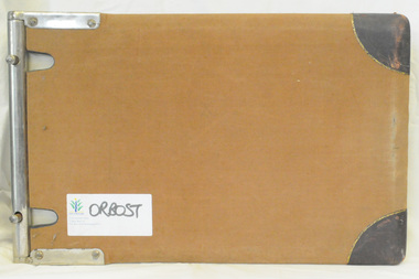
ledger, 1950's ; 1960's
This ledger was used by the Shire of Orbost to record transactions with the Country Roads board in 1950's and 1960's. The item was donated to Orbost & District Historical society from P.R.O.V. as a Place of Deposit (POD) item for safe keeping by a local history group or museum. The shire covered an area of 9,347 square kilometres and existed from 1892 until 1994 when it became part of the East Gippsland Shire Council. Orbost was at first included in the Bairnsdale Shire from 1882 and was later part of the Tambo Shire. Because of travelling distances the Croajingalong Shire was created in 1892 (name changed to Orbost Shire 17.2.1893 with James Cameron as the first Shire President. In 1994 it amalgamated to become part of East Gippsland Shire Council. The Country Roads Board was the government authority for the construction and maintenance of main roads in Victoria between 1913 and 1983. It was succeeded by the Road Construction authority on 1 July 1983 and later merged with the Road Traffic Authority on July 1 1989 to form the Roads Corporation. James Cameron, an Orbost farming pioneer and Member of the Legislative Assembly, fathered the Country Roads Board. This item is a hand-written record of accounts of the Orbost Shire local Government. It pre-dates computer records,The Shire of Orbost Council no longer exists having been absorbed into th East Gippsland Shire council.A heavy brown coloured ledger with steel bindings. Covers are probably wooden. It contains hand-written records of transactions the Country Roads Board. -
 Orbost & District Historical Society
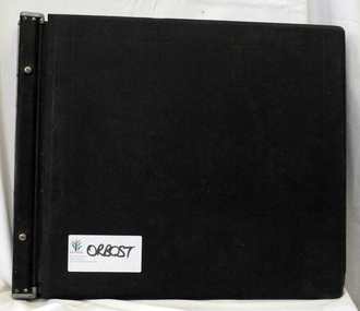
ledger, late 1950's - 1970's
This ledger was used by the Shire of Orbost in the late 1950's - 1970's.The item was donated to Orbost & District Historical society from P.R.O.V. as a Place of Deposit (POD) item for safe keeping by a local history group or museum. The shire covered an area of 9,347 square kilometres and existed from 1892 until 1994 when it became part of the East Gippsland Shire Council. Orbost was at first included in the Bairnsdale Shire from 1882 and was later part of the Tambo Shire. Because of travelling distances the Croajingalong Shire was created in 1892 (name changed to Orbost Shire 17.2.1893 with James Cameron as the first Shire President. In 1994 it amalgamated to become part of East Gippsland Shire Council. The Country Roads Board was the government authority for the construction and maintenance of main roads in Victoria between 1913 and 1983. It was succeeded by the Road Construction authority on 1 July 1983 and later merged with the Road Traffic Authority on July 1 1989 to form the Roads Corporation. James Cameron, an Orbost farming pioneer and Member of the Legislative Assembly, fathered the Country Roads Board This item is a hand-written record of Orbost Shire Council accounts. It pre- dates computer records. The Shire of Orbost local council no longer exists having been absorbed by the East Gippsland Shire Council.A black ledger with wooden covers. It contains hand-written records of transactions between Orbost Shire Council and the Country Roads Board.bottom left corner - Orbost in black on a white East Gippsland Shire logoledger accounts shire-of-orbost country-roads-board -
 Orbost & District Historical Society
magazine, CRB News, August 1976
By 1910 it had become apparent that there was a need for a central roads authority to take over responsibility from the Board of Lands and Works for the care and management of the main roads of the state of Victoria. Because there was no consistent and systematic policy for road maintenance Victorian roads were in a deplorable condition. At this time the use of the motor car accentuated the demands for better roads. As a result of these needs the Country Roads Act 1912 was proclaimed in 1913 providing for the establishment of the Country Roads Board as a central road authority with responsibility for those roads within the State considered to be main roads. the C.R.B. was responsible for the construction of roads and bridges including the Snowy River road bridges in Orbost. This was a major project involving not only a new bridge over the Snowy River (including Lochiel Lagoon), but other bridges over Ashby’s Gulch and Watt’s Gulch. These new bridges were opened in November 1976 with the unveiling of a plaque on the eastern end of the $2.4M Snowy River Bridge. (ref. May Leatch) This is a useful reference tool on the history of the construction of the Snowy River road bridges.A journal, titled "CRB News" . On the front cover the title is in orange print with No. 33 August 1976 above a coloured photo of a truck carrying two tiers of new vehicles along a main sealed road. It contains information and photos of the construction of the Snowy River road bridges.on front cover - handwritten in black - "M. I. Gilbert"crb-news country-roads-board snowy-river-road-bridges -
 Marysville & District Historical Society
Photograph (Item) - Black and white photograph, Fernshaw, c1900
An early black and white photograph taken at Fernshaw.An early black and white photograph taken at Fernshaw. Fernshaw was a rural township 63 km north-east of Melbourne and 10 km north-east of Healesville. Situated on the Watts River, near where a log had fallen making a convenient crossing, Fernshaw was settled in the 1860s. It provided good country for orchards and berry growing. The location was at the foot of Blacks Spur, with Mounts Juliet and Mondah rising on either side, providing spectacular scenery. There were nearby fern gullies giving rise to the name – ‘shaw’ is old English for thicket or wood. By 1875 Fernshaw had a post office (1865), two hotels, a school (1871) and stores. It was famed for its beauty, attracting tourists. In 1886 the Melbourne and Metropolitan Board of Works began work on the Watts River water catchment scheme – later to become Maroondah – and the Board obtained approval for the catchment country to be reserved and kept free of settlement. This required the removal of the Fernshaw township, which was completed by about 1890. The area was described in the 1903 Australian handbook:ARMSTRONG COLLECTION 42 STATION STREET/ SANDRINGHAM 3191/ TEL. (03) 9521 5442/ IAN M.L. ARMSTRONG OAMfernshaw, healesville, watts river, orchard, berry orchard, blacks spur, black spur, mount juliet, mount mondah, maroondah dam, victoria -
Federation University Historical Collection
Book, Toni Woolley et al, Port Fairy Community and Organisational Plan, 1999
Port Fairy Community and Organisational Plan. University of Ballarat Students' Project.White bound book of 35 pages plus 6 appendices.port fairy, toni woolley, tamara lang, janelle gilbert, ben balshaw, grant caromody, executive summary, introduction, background to port fairy, methodology, limitations, appraisal of tourism planning and development to date, assessment of local community issues, attitudes and involvement in tourism, roles of local and regional tourism associations, effectiveness of local & regional tourism associations, analysis of services and service quality, moyne shire council, friends of port fairy, tourism victoria, country victoria tourism, great ocean road marketing, shipwreck coast tourism, port fairy tourism association inc, moyne shire, department of natural resources and environment, the western coastal board, tourism accreditation board of victoria, george borg, craig delahoy, michael hearn, jodie honan, judith kershaw, andrea lowenthal, neil martin, john ploenges, james purcell, peter strickland, mark thompson, libby wilson, michael pearlman, battle of the moyne, tourism planning, great ocean road -
Bendigo Historical Society Inc.
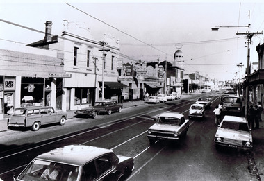
Photograph - ROAD WORKS
... DVD. Road works. Country Roads Board. Victoria..... Road works. Country Roads Board. Victoria. Photograph ROAD ...DVD. Road works. Country Roads Board. Victoria. -
 St Kilda Historical Society
Photograph, c. 1970s?
... Roads Board, Victoria Australia. Negative no. 75-3124G. Date... Pleas acknowldge Country Roads Board, Victoria Australia ...stamped on back: Country Roads Board negaitve no. 75 3124Gblack and white photograph unmounted, good conditionH7 St Kilda road. When reproduced Pleas acknowldge Country Roads Board, Victoria Australia. Negative no. 75-3124G. Date: �., General Description:�.. -
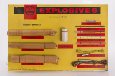 Forests Commission Retired Personnel Association (FCRPA)
ICI Explosives Sampler
The Forests Commission had a large and active engineering branch which was often called upon for major demolition or quarry work. Most overseers, as well as some foresters, were trained in the use of explosives to “blow stuff up” such as removing stumps and rocks from roads. Districts usually had a small powder magazine tucked away in the bush for storage of gelignite and detonators.Sample board showing examples of explosives and detonatorsroad construction and maintenance. -
Lakes Entrance Historical Society
Photograph, Country Roads Board, 1925 c
... at Won Wron South Gippsland Victoria Photograph Country Roads ...Also four black and white photographs at same time showing tractor working and large log on timber jinker 05187.1, .2, .3 .4 Also three black and white copies of the original photos 05187.5, .6, .7 10 x 15 cmBlack and white photograph of small truck beside five large foundation piles for the Swan Reach bridge cut at the CRB timber coup at Won Wron South Gippsland Victoriajetties, recreation -
 Whitehorse Historical Society Inc.
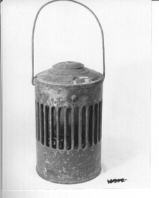
Functional object - Lamp
... . This one belonged to the Country Roads Board of Victoria.... or the Railways. This one belonged to the Country Roads Board of Victoria ...Lamp used to warn of dangerous area or objects on road, footpath or railway gates owned by Council or the Railways. This one belonged to the Country Roads Board of Victoria.Red painted outer case with lid. Inner red glass lamp and kerosene holder with wire to lift out for filling. Gaps all round to allow light to shine out and to let air in to allow lamp to burn. Country Roads owned.lighting, kerosene & oil -
 Whitehorse Historical Society Inc.
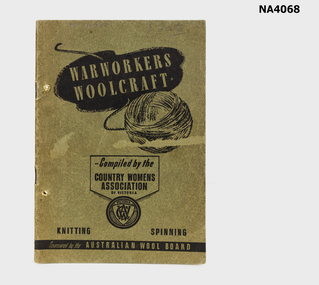
Functional object - Book - Warworkers Woolcraft, Warworkers Woolcraft, During WW1
Published to help the war effort and contribute to the defence of the country. Patterns selected in collaboration with the three services-colours and garments by active services in air,on land or at sea.Green-grey light card cover. 32 pages compiled by the Country Womens Association of Victoria sponsored by the Wool Board.J.Tatebooks, handcrafts -
 Rutherglen Historical Society
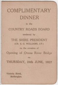
Menu and Toast List, Complimentary Dinner to the Country Roads Board, 1937 (exact)
Dinner was held at the Victoria Hotel, Rutherglen. The Shire President was Cr. S.G. Williams, J.P.Small card folder, with menu and toast list"Complimentary Dinner to the Country Roads Board tendered by the Shire President on the occasion of the opening of the Ovens River Bridge on 24th June, 1937"country roads board, ovens river bridge, opening celebration -
 Kew Historical Society Inc
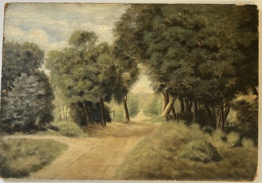
Painting - Country Road, Frankston, Hubert C McDonald
The French Collection was donated to the Society in 2022. This collection includes documents, artworks, books, costumes and artefacts belonging to two families. A number belonged to, or were made by the grandparents of the donor: Vera May Wing and her husband Hubert Charles McDonald. [Other items belonging to Vera and Hubert are in the collections of the Australian Performing Arts Museum and Museum Victoria.] A second significant group of objects were gifts made to the donor's family by Lucy (Jean) Hornby of Queen Street, Kew whose family had been early settlers in the district.Gift of Anna French, 2022Frankston country road. Oil on composite board by Hubert Charles McDonald.Reverse: "HC McDonald / Frankston"artworks, frankston, hubert c mcdonald -
Kew Historical Society Inc
Journal, The Kewriosity Sheet Vol.1 No.9 : February 1980
What's doing in Kew for February / p1. Work Program: Kew Employment Project - Work, training and guidance / p1. Unemployment problems / Jim Fyfe p1. Will you help? [Henry Pride Volunteer Service] / p2. Historical Society / Elizabeth Mackie p2. Henry Pride Centre - Studley Park - Weekly Church Services / p2. The Kintore Social Club / p2. An Association of Relatives and Friends of the Emotionally Ill (A.R.A.F.E.M.I) / p2. C.R.B. - Country Roads Board Route E6 public display / p2. Limericks / p2. Council News [Council Meeting Dates 1980; Open Mayor's Room] / p2. Evaluation!! - Evaluation of Kewriosity Sheet] / p2. Meals on Wheels / p2.The Kewriosity Sheet (1979-83) was first published in the City of Kew (Victoria) in June 1979 as a two-sided 'community newssheet'. It aimed to: 'share news about Kew happenings and Kew people, and to exchange ideas about living in Kew'. Later issues gradually evolved into a 4-page, quarto sized publication. The Kewriosity Sheet was superseded by the Kew Council publication 'Kewriosity' (1983-1994).non-fictionWhat's doing in Kew for February / p1. Work Program: Kew Employment Project - Work, training and guidance / p1. Unemployment problems / Jim Fyfe p1. Will you help? [Henry Pride Volunteer Service] / p2. Historical Society / Elizabeth Mackie p2. Henry Pride Centre - Studley Park - Weekly Church Services / p2. The Kintore Social Club / p2. An Association of Relatives and Friends of the Emotionally Ill (A.R.A.F.E.M.I) / p2. C.R.B. - Country Roads Board Route E6 public display / p2. Limericks / p2. Council News [Council Meeting Dates 1980; Open Mayor's Room] / p2. Evaluation!! - Evaluation of Kewriosity Sheet] / p2. Meals on Wheels / p2. community publications --- kew (vic.), the kewriosity sheet, newsletters - kew (vic.)