Showing 201 items
matching walking tracks
-
 Southern Sherbrooke Historical Society Inc.
Booklet, "The Hiker's Handbook Of Wonderful Walks In Victoria", May-36
... Photocopy of 1936 booklet detailing walking tracks... of 1936 booklet detailing walking tracks in Victoria "The Hiker's ...Photocopy of 1936 booklet detailing walking tracks in Victorialockwood, belgrave, selby, narre warren, dandenong reservoir -
 Federation University Historical Collection
Photograph - Photograph - Black and White, Top of Clissold Street, Ballarat, 1992
... walking track..." and "walking track down to Princes St, Bllt East"... clissold street ballarat ballarat east walking track East Ballarat ...black and white photographinscriptions in pencil on verso "Clissold St, Ballarat" and "walking track down to Princes St, Bllt East"clissold street, ballarat, ballarat east, walking track, east ballarat heritage project -
 Whitehorse Historical Society Inc.
Photograph, Deep Creek Walking Trails, 28/11/1984 12:00:00 AM
... Four coloured photographs of various views along walking... photographs of various views along walking track near Deep Creek ...Four coloured photographs of various views along walking track near Deep Creek Mitchamwalking trails, deep creek -
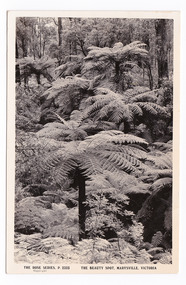
 Marysville & District Historical Society
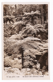
Postcard (item) - Black and white postcard, Rose Stereograph Company, The Beauty Spot, Marysville, Victoria, 1913-1967
... walking track...An early sepia photograph of the walking track known... photograph of the walking track known as The Beauty Spot ...A postcard in a series produced by the Rose Stereograph Company in Victoria, Australia as a souvenir of Marysville.An early black and white photograph of the walking track known as The Beauty Spot in Marysville in Victoria. The Beauty Spot walking track is one of a number of walking tracks in and around Marysville and the district.POST CARD The "Rose" Series/ De Luxe A Real Photograph/ Produced in Australia Published by the Rose Stereograph Co.,/ Armadale, Victoria.beauty spot, walking track, marysville, victoria, postcard, p. 2323, rose series postcard, souvenir -
 Whitehorse Historical Society Inc.
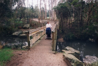
Photograph, Blackburn Lake Sanctuary
... Walking track over an offshoot of the Blackburn Lake which... Mitcham melbourne Blackburn Lake Sanctuary Walking track over ...Walking track over an offshoot of the Blackburn Lake which can be seen in the behind the trees. An adult pushing a pram and a bridge.blackburn lake sanctuary -
 Marysville & District Historical Society
Postcard (item) - Black and white postcard, Rose Stereograph Company, The Beauty Spot, Marysville, Victoria, 1913-1967
... walking track...An early black and white photograph of the walking track... photograph of the walking track known as The Beauty Spot ...A postcard in a series produced by the Rose Stereograph Company in Victoria, Australia as a souvenir of Marysville.An early black and white photograph of the walking track known as The Beauty Spot in Marysville in Victoria. The Beauty Spot walking track is one of a number of walking tracks in and around Marysville and the district.POST CARD The "Rose" Series/ De Luxe A Real Photograph/ Produced in Australia Published by the Rose Stereograph Co.,/ Armadale, Victoria. "Mary-Lyn"/ Marysville/ Vic/ 11"2"48 Dear Mr. & Mrs. Hooper and Resa,/ I suppose its pretty hot up/ there because its hot enough/ here, we're enjoying our/ selves pretty well and/ spend the best part of every/ afternoon just lying around./ I'm sorry I didn't thankyou/ for the cloth when Les wrote/ but thanks very much for getting it/ and I think the red should/ be as pretty as the blue./ We hope we/ see you as we fly over/ on Fri. 20th we'll be watching/ out as best we can. Everyone will/ know our news before it/ even gets in the Standard/ won't they. Isobel reckons/ she never knew an engage-/ ment with so much fuss/ before. We are going out/ to Luna Park on Saturday/ night so should have some fun./ Well there's not a great lot of news/ we've been for some good walks,/ Geoff and I the others don't like/ walking. That's all Lots of love/ Joan XXXXbeauty spot, walking track, marysville, victoria, postcard, p. 2323, rose series postcard, souvenir -
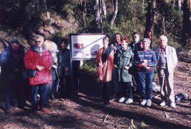 Lakes Entrance Historical Society
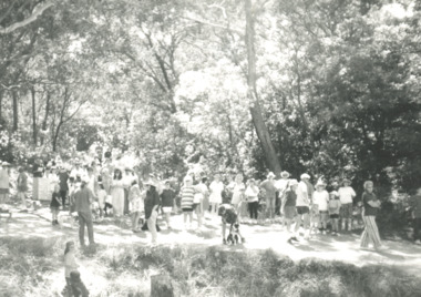
Photograph - Mississippi Creek, 1998
... sign at the opening of the Mississippi Creek walking track... at the opening of the Mississippi Creek walking track project ...Date made June 1998Colour photograph of a group of people at an interpretative sign at the opening of the Mississippi Creek walking track project at Colquhoun Forest, Lakes Entrance, Victoria.recreation, celebration -
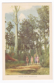 Marysville & District Historical Society
Postcard (item) - Colour tinted postcard, Nucolorvue Productions, Hikers Track, Marysville, c1950s
... walking track...An early colour photograph of a group of ladies walking...An early colour photograph of a group of ladies walking... photograph of a group of ladies walking along a track in Marysville ...An early colour photograph of a group of ladies walking along a track in Marysville in Victoria.An early colour tinted potograph of a group of ladies walking along a track in Marysville in Victoria. This postcard was produced by Nucolorvue Productions in Elwood, Victoria as a souvenir of Marysville.POST CARD NUCOLORVUE PRODUCTIONS, ELWOOD, VICTORIAwalking track, marysville, victoria, nucolorvue productions, postcard, souvenir -
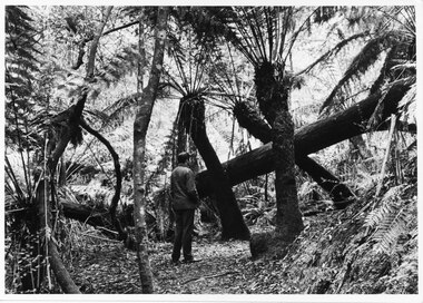 Halls Gap & Grampians Historical Society
Photograph - B/W
... Man facing away from camera, on walking track, looking... camera, on walking track, looking at large fallen tree trunk. He ...Typical of promotional photos taken by Forestry Commission VictoriaMan facing away from camera, on walking track, looking at large fallen tree trunk. He is surrounded by very tall tree ferns.Forests Commission, Victoria and picture logo printed in R/H white border LC.32 written on backscenery, walkers -
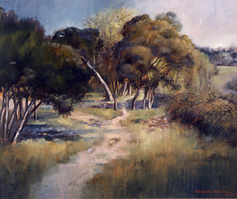 Nillumbik Shire Council
Harris (Maureen) SMITH (b.AUS - active 80's), Evening Eltham, 1984
... Painting of a landscape at dusk with dirt walking track... of a landscape at dusk with dirt walking track and trees somewhere ...The painting was purchased from the Eltham Outdoor Art Show. Smith endeavours to capture mood, atmosphere and light in this work by heightening and intensifying the imagery where possible. Smith is concerned with expressing a 'sense of place' inherent in the subject matter. Painting of a landscape at dusk with dirt walking track and trees somewhere in Eltham. Oil on composition board. Moulded frame. Painted in the 'Western Realist Tradition'. Signed 'HARRIS SMITH/84' Hand painted in capitals in red paint; bottom right. eltham, painting, landscape, smith, evening -
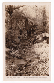 Marysville & District Historical Society
Postcard (item) - Black and white postcard, Rose Stereograph Company, The Wolfram Track, Marysville, Victoria, 1913-1967
... wilks creek walking track... is part of the Wilks Creek Walking Track near Marysville... of the Wolfram Track which is part of the Wilks Creek Walking Track near ...A postcard in a series produced by the Rose Stereograph Company in Victoria, Australia as a souvenir of Marysville.A black and white photograph of the Wolfram Track which is part of the Wilks Creek Walking Track near Marysville in Victoria. The Wolfram Track is named after the Wilks Creek Wolfram Mine which opened in around 1894. Wolframite is one of the principle ores of tungsten. The discovery was made in Wolfram Creek by a Mr Robinson who was probably a local of the district. Four creeks eventually proved to carry alluvial deposits of the ore; Wolfram Creek, Opas Creek, Quartz Creek and Main Creek. These creeks run south-east into Deep Creek, a tributary of the O'Shannassy River which, in turn, runs into the Yarra River.POST CARD The "Rose" Series/ De Luxe A Real Photograph/ Produced in Australia Published by the Rose Stereograph Co.,/ Sydney and Melbourne.wolfram track, wilks creek walking track, marysville, victoria, p. 2332, walking track, rose series postcard, postcard, souvenir, wolframite, wolfram creek, opas creek, quartz creek, main creek, deep creek, o'shannassy river, yarra river, mining -
 Marysville & District Historical Society
Photograph (item) - Black and white photograph, Unknown
... A black and white photograph which shows a woman walking... a white dress walking along the track that leads to the base... photograph which shows a woman walking along the track that leads ...A black and white photograph which shows a woman walking along the track that leads to the base of Steavenson Falls.A black and white photograph which shows a woman walking along the track that leads to the base of Steavenson Falls. The Steavenson Falls is named after the Victorian Assistant Commissioner of Roads and Bridges, John Steavenson who arrived in Victoria in the early 1860s.steavenson falls, marysville, victoria, waterfalls -
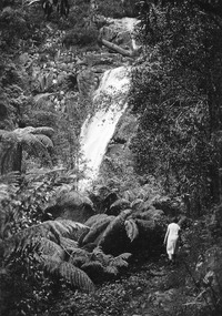
 Halls Gap & Grampians Historical Society
Photograph - B/W, C 1960s
... of the Wonderland/ Pinnacle walking track.... walking track. SCENERY Wonderland Range Copyright photograph ...Rocky gorge is known as The Grand Canyon, part of the Wonderland/ Pinnacle walking track.Photo shows a rocky gorge. Aroad can be seen through bushland in the background. Two figures can be seen middle foreground about to climb a ladder to higher level . A handrail is visible on the track above the hikers.Copyright photograph. This photograph may be reproduced on condition that it is acknowledged as " Victorian Railways'.scenery, wonderland range -
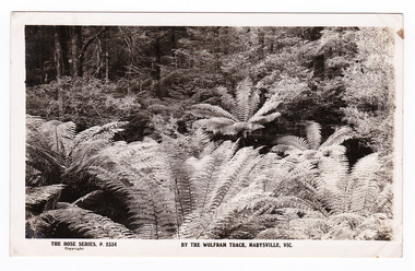 Marysville & District Historical Society
Postcard (item) - Black and white postcard, Rose Stereograph Company, By the Wolfram Track, Marysville, Vic, 1913-1967
... wilks creek walking track... that the Wolfram Track, which is part of the Wilks Creek Walking Track... of the Wilks Creek Walking Track, runs through. The Wilks Creek Walking ...A postcard in a series produced by the Rose Stereograph Company in Victoria, Australia as a souvenir of Marysville.A black and white photograph of a part of the forest that the Wolfram Track, which is part of the Wilks Creek Walking Track, runs through. The Wilks Creek Walking Track is in Marysville in Victoria. The Wolfram Track is named after the Wilks Creek Wolfram Mine which opened in around 1894. Wolframite is one of the principle ores of tungsten. The discovery was made in Wolfram Creek by a Mr Robinson who was probably a local of the district. Four creeks eventually proved to carry alluvial deposits of the ore; Wolfram Creek, Opas Creek, Quartz Creek and Main Creek. These creeks run south-east into Deep Creek, a tributary of the O'Shannassy River which, in turn, runs into the Yarra River.POST CARD The "Rose" Series/ De Luxe A Real Photograph/ Produced in Australia Published by the Rose Stereograph Co.,/ Armadale, Victoria.wolfram track, wilks creek walking track, walking track, marysville, victoria, p. 2334, rose series postcard, postcard, souvenir, p. 2332, wolframite, wolfram creek, opas creek, quartz creek, main creek, deep creek, o'shannassy river, yarra river, mining -
 Whitehorse Historical Society Inc.
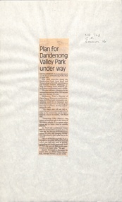
Newspaper - Article, Plan for Dandenong Valley park under way, 1/06/1992
... , cycling and walking tracks, bushland, picnic facilities..., cycling and walking tracks, bushland, picnic facilities ...Development of park along Dandenong Creek from Knox and Nunawading to Rowville and Mulgrave featuring wetlands, billabongs, cycling and walking tracks, bushland, picnic facilities and wildlife.dandenong creek, melbourne water, floyd, jeff, dandenong valley metropolitan park, chesterfield, chris, parks and reserves -
 Lakes Entrance Historical Society
Photograph - Walking Track Protest Lakes Entrance, Lakes Post Newspaper, 1/03/1995 12:00:00 AM
... Walking Track Protest Lakes Entrance...Protest about the hazardous walking track from Kalimna...Protest about the hazardous walking track from Kalimna ...Protest about the hazardous walking track from Kalimna Heights to the Princes Highway at Lakes Entrance Victoria.Black and white photograph of a crowd of local residents Also two black and white photographs taken at same event of two protestors Judy Jerkins and sonprotest, events, track -
Glenelg Shire Council Cultural Collection
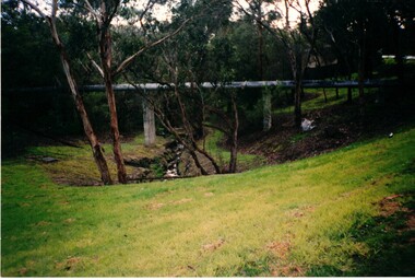
Photograph - Photograph -Bridge, n.d
... , narrow walking track along right side of creek.... bed of creek. Banks of grass, narrow walking track along right ...Sourced from Casterton Town Hall (former Shire of Glenelg)Coloured photograph. Side view of bridge, wooden rails, three wooden supports, taken from bed of creek. Banks of grass, narrow walking track along right side of creek. -
 Lakes Entrance Historical Society
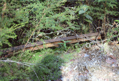
Photograph - Tramline, Davies Judy, 2008
... the walking track, which ran from the Mississippi Creek quarry... of a remnant of the tramway, beside the walking track, which ran from ...This is the paired after photograph used in the 150 year, Lakes Entrance 1858-2008 display.|The before paired photograph number 01733.3|Also one 12 x 16 framed photograph used in room display.Colour photograph of a remnant of the tramway, beside the walking track, which ran from the Mississippi Creek quarry to the head of the North Arm. It shows one length of ironrail in the vegetation, Lakes Entrance Victoria. public works, transport, historic site -
 Greensborough Historical Society
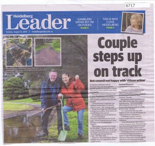
Newspaper Clipping, Couple steps up on track, by Courtney Beaumont, 13/08/2019
... Rob and Christine Granter repaired a popular walking track... a popular walking track at Banyule Flats which was in poor condition ...Rob and Christine Granter repaired a popular walking track at Banyule Flats which was in poor condition, and was criticised by the Mayor of Banyule for taking independent action.Black and white text and colour imagesbanyule flats, rob granter, christine granter, banyule city council -
 Buninyong Visitor Information Centre
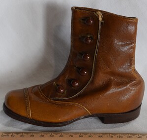
Footwear - Boot, Graham's Tannery, Graham's Tannery made child's boot
... .). The location is now part of the De Soza Park walking track. ....). The location is now part of the De Soza Park walking track. Footwear ...The Graham's Tannery in Buninyong was located on the western edge of town on the Midland Highway (Learmonth Street.). The location is now part of the De Soza Park walking track. Tan leather ankle height left foot boot with six leather finished buttons. Has a leather sole. Embossed shield on sole with the letters CRS entwined in a business identification. footwear, tanneries, industry -
Whitehorse Historical Society Inc.
Letter - Correspondence, Yarran Dheran, 17/01/1979 12:00:00 AM
... Regarding walking and bicycle tracks between Schwerkolt... Clerk, Nunawading 17/1/1979 regarding walking and bicycle tracks... Mitcham melbourne Regarding walking and bicycle tracks between ...Letter from Yarran Dheran Committee of Management to Town Clerk, Nunawading 17/1/1979.Letter from Yarran Dheran Committee of Management to Town Clerk, Nunawading 17/1/1979 regarding walking and bicycle tracks between Schwerkolt Cottage and Yarran Dheran. With letter from Ann Creber to George Cox regarding meeting on the subject.Letter from Yarran Dheran Committee of Management to Town Clerk, Nunawading 17/1/1979.yarran dheran, parks and reserves, schwerkolt cottage, walking trails, bicycle paths -
 Stawell Historical Society Inc
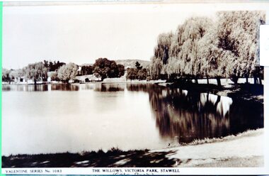
Photograph - View of Cato Lake, Black & White photo of Valentine Series No 1083 Willows Victoria/Cato Lake
... of the walking track and willows around the lake. Houses can be seen... of the walking track and willows around the lake. Houses can be seen ...View of Victoria/Cato Lake showing just a short section of the walking track and willows around the lake. Houses can be seen in the distance. The lake is very still as the trees are reflected in the water.Black & White photo of Valentine Series No 1083 Victoria/Cato lake. The photo is of a post card of Victoria/Cato Lake. Willow trees line the right side of the photograph. Valentine Series No 1083. The willows Victoria Park, Stawell. stawell -
 Lakes Entrance Historical Society
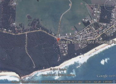
Photograph - Lake Tyers Beach, Google Earth, 2014
... , walking track with ocean beach on Bass Strait in background, Bream... Beach Road, Barracouta Road and Salmon Road, walking track ...Colour photograph of Lakes Beachfront Holiday Resort showing Lake Tyers Beach Road, Barracouta Road and Salmon Road, walking track with ocean beach on Bass Strait in background, Bream Road in foreground, Lake Tyers Beach VictoriaLakes Beachfront Holiday Reocean, caravan parks -
 Federation University Historical Collection
Map, Municipality of Ballarat East, 1857
... (1854) and the walking tracks and roads on the Ballarat East... shows the locality of the Eureka Stockade (1854) and the walking ...Gold was discovered in Ballarat in 1851. This plan was created six years later and names some of the great gold locations of Ballarat East. It also shows the locality of the Eureka Stockade (1854) and the walking tracks and roads on the Ballarat East Goldfield.In 2007 this map was listed on the inaugural Ballarat Treasure's Register.Large map backed onto linen. The map has read and blue highlights, and identifies areas such as Mount Pleasant, Golden Point, White Flat, Nightingale, Malekoff, Old Post Office Hill, Red streak, Gumtree Flat, Old Gravelpits, Bakery Hill, Ballaarat Flat, The Camp, Specimen Gully, Pennyweight Hill, Warrenheip Gully, Gays Gully, Pennyweight Flat, Eureka, Black Hill, Pinchgut, Crocodile, Hit or Miss, Little Bendigo, Brown Hill, Mopoke, Cricket Reserve, Canadian Hotel, Ballarat Eastmount pleasant, golden point, white flat, nightingale, malekoff, old post office hill, red streak, gumtree flat, old gravelpits, bakery hill, ballaarat flat, the camp, specimen gully, pennyweight hill, warrenheip gully, gays gully, pennyweight flat, eureka, black hill, pinchgut, crocodile, hit or miss, little bendigo, brown hill, mopoke, cricket reserve, canadian hotel, ballarat eastm phillips, john phillips, field draughtsman, ballarat east, ballarat east map -
 Mission to Seafarers Victoria
Photograph - Photograph, Black and white, Allan Charles Quinn, Landing Docks, 30 September 1949
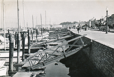
... includes a walking track and street lighting in front of a road... of the photograph is the streetscape which includes a walking track ...Allan Charles Quinn went to sea aged 16 and photographed his work and the places he visited. His collection of photo albums provides a pictorial autobiography for a period in his life. Included in the Allan Charles Quinn Collection are a series of letters written to and from his mother.Black and white photograph of landing docks at San Francisco. To the right of the photograph is the streetscape which includes a walking track and street lighting in front of a road and row of shops or houses. To the centre of the photograph are the ramps to reach the jetty where the yachts are moored. To the left of the photograph are the bows of a long line of yachts. In the background of the photograph there is a large multi-storeyed building.Blue/green ink, handwritten on reverse: "30/9/49" Handwritten in pencil: "K9/A"san francisco, sailing boats, ramps, promenades, allan charles quinn -
 Lakes Entrance Historical Society
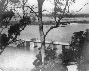
Photograph - North Arm bridge Lakes Entrance Victoria, 1920c
... . The walking track to Kalimna Heights visible right foreground. Lakes.... The walking track to Kalimna Heights visible right foreground. Lakes ...Other photographs in album of this area dated 1928Black and white photograph of the North Arm Bridge, taken from Kalimna Heights looking towards the Entrance and Bullock Island. Bridge has no side rails, appears to be chain and wire between concrete posts. Sedan car passing over the bridge. The walking track to Kalimna Heights visible right foreground. Lakes Entrance Victoriabridges, waterways, transport -
 Eltham District Historical Society Inc
Book, Melway Great Melbourne street directory including Geelong, Phillip Island Healesville, Bellarine & Mornington Peninsulas, 1998
... paths, walking tracks & horse trails, latest public transport..., walking tracks & horse trails, latest public transport information ...25th edition. Coloured detailed maps accessed by a street or location index. Cover: (Includes) New Southbank map including Crown Complex, enlargements of Footscray and Kensington, bike paths, walking tracks & horse trails, latest public transport information, South east Australia tours maps, Vic Roads new route numbers, map of Australia1 atlas (22, 772 p.) : col. maps ; ISSN 03113957streets, maps, roads, melbourne -
 Orbost & District Historical Society
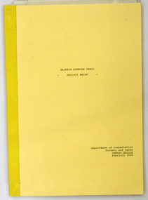
document, BALDWIN SPENCER TRAIL Project Brief 1988, February 1988
... Walking Tracks Project. The Baldwin Spencer Trail closely... Walking Tracks Project. The Baldwin Spencer Trail closely follows ...This document was produced by the Department of Conservation, Forests & Land Management, Orbost, to commemorate the visit by Baldwin-Spencer in 1989 as part of the Bicentennial Walking Tracks Project. The Baldwin Spencer Trail closely follows the route of scientist and explorer William Baldwin Spencer. Sir Walter Baldwin Spencer KCMG (23 June 1860 – 14 July 1929) was an English-Australian biologist and anthropologist. this booklet is a useful reference tool.A document of 10 pp with a cream cover, titled, Baldwin Spencer Trail Project Brief Feb 1988. It contains mapsbaldwin-spencer -
 Halls Gap & Grampians Historical Society
Photograph - B/W, C 1890
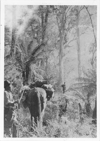
... walking track routes through the Wonderland Range and in the Mt... responsible for finding many of today's walking track routes through ...The man with the horse is Charles D'Alton, his cousin Alfred is beckoning him to come on. Charles was ther son of William D'Alton if "Silver Springs" on Dairy Creek, and Fred (Alfred) was the son of John D'Alton, Stawell Borough engineer. Fred and Charles were responsible for finding many of today's walking track routes through the Wonderland Range and in the Mt. Rosea area. The second copy is a transparency (slide) , no. 182 in the slide box.Photo shows man, left side corner with pack horse andother man middle ground with arm raised"Charles D'Alton beckoning to his cousin Alfred to come on" finding the best routegilbert rogers, vehicle track, people, d'alton -
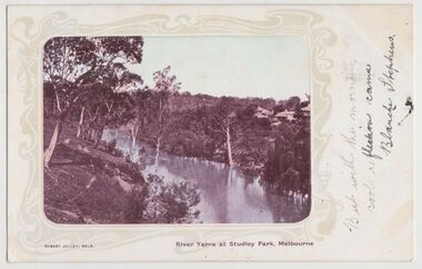 Kew Historical Society Inc
Postcard, River Yarra at Studley Park, Melbourne, 1900-04
... and meandering walking tracks. Three very small figures are sitting... of the river includes some remnant vegetation and meandering walking ...Monochrome postcard titled lower right: “RIVER YARRA AT STUDLEY PARK, MELBOURNE”. The postcard was produced by ROBERT JOLLEY, MELB, (active 1900-1904). The photo is positioned to the left of the card and framed by an art nouveau design. A handwritten annotation on the front reads “BUT WITH THE MORNING / COOL REFLECTION CAME / BLANCHE STEPHENS”. On the reverse, there is a handwritten address in black ink to: MISS L STEPHENS / 26 WEST TERRACE / ADELAIDE. There is no division on the reverse of the postcard, dating it to before 1905. It lacks a postage stamp and postmark. Monochrome postcard of the River Yarra in Studley Park. The view is of the Yarra and its banks, with Kew on the left and Abbotsford on the right, as it appeared in the years 1900-1904. On the Abbotsford side of the river, there are a number of weeping willows lining the banks and houses on the hillside. The Studley Park side of the river includes some remnant vegetation and meandering walking tracks. Three very small figures are sitting on the Kew side. "RIVER YARRA AT STUDLEY PARK, MELBOURNE"river yarra -- kew (vic.), postcards -- kew, postcards -- studley park, robert jolley