Showing 78 items matching "warrigal road"
-
 Surrey Hills Historical Society Collection
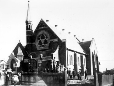
Photograph, Surrey Hills Presbyterian Church, Canterbury Road, Surrey Hills in 1910
... warrigal road... in the collection of Miss Annie Mills of "Terreglea" in Warrigal Road... of "Terreglea" in Warrigal Road, Surrey Hills. Her father John Mills ...Taken at the Opening Service in 1910. Photo originally in the collection of Miss Annie Mills of "Terreglea" in Warrigal Road, Surrey Hills. Her father John Mills was a Church elder. Alfred Jacobs could be on the extreme right; Win Jacobs (Mrs Win Yarnold) just visible on the left. Win was connected with the Mills family through the mother (Eleanor Dobson Mills) of her half-sister; Eleanor was Henry Atwood Jacobs' first wife.A black and white photograph of a church with a tall spire. It is bounded by a picket fence. There are a number of people exiting from the side of the church. Many people are wearing hats.To Alfie / with love from / Auntie Annie (Mills) sister of first Mrs Jacobs / mother of Amelia Alan Jacobs / known as Amy. Surrey Hills Presbyterian Church / could be Alf Jacobs an extreme right / ..... opening. From Win Yarnold (nee Jacobs) born at "Spencey Croft" / Canterbury Rd 1905surrey hills presbyterian church, canterbury road, surrey hills, warrigal road, clothing and dress, hats, miss annie mills, mr alfred jacobs, miss win jacobs, miss winifred atwood jacobs, mrs win yarnold, mrs winifred yarnold, mr john mills, churches -
 Surrey Hills Historical Society Collection
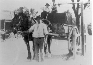
Photograph, Stand-pipe at the corner of Warrigal and Riversdale Roads, Surrey Hills, c1916, c1916
... warrigal road... / CAME FROM THE STAND-PIPE AT THE WARRIGAL ROAD TRAM TERMINUS... AT THE WARRIGAL ROAD TRAM TERMINUS. PREVIOUSLY WATER WAS / PURCHASED FROM ...This was part of an exhibition mounted by the Surrey Hills State Savings Bank in 1976. The original print had a text which was included in our copy print as follows: "EVEN IN 1916, WATER SUPPLIES FOR MANY SURREY HILLS FARMERS AND MARKET GARDENS STILL / CAME FROM THE STAND-PIPE AT THE WARRIGAL ROAD TRAM TERMINUS. PREVIOUSLY WATER WAS / PURCHASED FROM THE VILLAGE TANK AT THE CORNER OF WINDSOR CRESCENT AND UNION ROAD. / THE PRICE WAS 1/- FOR 400 GALLONS."Black and white photo of a horse and water cart in position at the stand-pipe. A man holds the horse's reins and 2 young boys are perched on the cart. In the background is a building that may be a shop with wagons outside and further down the road is a tram.horse-drawn vehicles, water supply, warrigal road, riversdale road, transport, surrey hills, standpipe -
 Surrey Hills Historical Society Collection
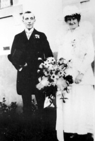
Photograph, Wedding Day of Amelia Amy Jacobs and James Dodgshun from Surrey Hills, 1916
... warrigal road..." in Boundary (Warrigal) Road, Surrey Hills. Amelia attended Ormiston... grandfather, "Terreglea" in Boundary (Warrigal) Road, Surrey Hills ...Amelia Allan (Amy) Jacobs on her marriage to James Dodgshun in 1916; photographed at the home of her grandfather, "Terreglea" in Boundary (Warrigal) Road, Surrey Hills. Amelia attended Ormiston Girls' School in Mont Albert soon after its opening in 1900. Her mother was Eleanor Mills, youngest daughter of Robert Shortbridge Mills and Ann Lovelady. She died soon after the birth of Amy. Her father was Henry Atwood Jacobs. Following Eleanor's death Henry married Amy Lilian Scales. The donor Winifred Yarnold (nee Jacobs) was their youngest daughter and Amy's half-sister.Lady dressed as bride wearing a white dress and possibly a lace jacket with a fluffy collar and matching hat, carrying a large bouquet of flowers. The man is wearing a dark suit and carrying a top hat.wedding dresses, house names, surrey hills, warrigal road, clothing and dress, hats, terreglea, the tower house, weddings, wedding parties, ormiston girls school, schools, mont albert, miss amelia allan jacobs, miss amy jacobs, mr james dodgshun -
 Surrey Hills Historical Society Collection
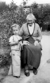
Photograph, Mary Selina Simpson, c1940
... warrigal road... Inglefinger bought James Staig's farm in Boundary (Warrigal) Road... (Warrigal) Road, near the corner of Bona Vista Avenue, Surrey Hills ...Mary Selina Inglefinger was born in 1856 in Kings Plain, NSW and was the eldest daughter of Joseph Inglefinger and his wife Maria Viktoria Bertel (Barthl), both of whom were born in Germany; they applied to come to Australia in 1854. They had 10 children, the first 8 born in Kings Plain. In 1879, Joseph Inglefinger bought James Staig's farm in Boundary (Warrigal) Road, near the corner of Bona Vista Avenue, Surrey Hills. The 1903 and 1905 electoral rolls list them in Boundary Road. In 1875 Mary married Charles Simpson, stepson of James Staig in Scots Church, Melbourne. They had 3 boys and 3 girls. This photograph was taken with her great-grandson in 1940.A black and white photograph of a lady sitting on a chair with a young toddler standing beside her.On back of photo: Mary Selina Simpson / (nee Inglefinger) / c.1940 / (born Mary Maghlina) / born c. 1857(miss) mary inglefinger, (mr) joseph inglefinger, (mr) james staig, warrigal road, surrey hills, bona vista avenue, (mrs) mary simpson, boundary road, (miss) mary maghlina inglefinger -
 Box Hill Historical Society
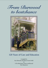
Book, From Burwood to bestchance : 120 years of care and education, 2016
... Warrigal Road, Burwood, Victoria, Australia ...Illustrated history of Burwood Boys Home, Child and Family Care, and bestchance, Child, Family Care. From original beginnings in 1895 when founder Robert Campbell Edwards established a home for the waifs of Melbourne, to the present organisation caring for families and children, providing child care, early intervention programs, special primary education ( Cheshire School) and adult training. In 2007, Ken Masterton's book "A Tea Merchant's Vision and Beyond - a history of the Burwood Boys' Home" (which is reproduced in full in this edition) begins with the vision of tea merchant Robert Campbell Edwards and "gives a valuable summary of the organisation's achievements".xvi, 202 pages : illustrations (some colour), portraits (some colour), colour maps; includes Appendices lists of leadership and Life Governors 1895 to 2016 non-fictionIllustrated history of Burwood Boys Home, Child and Family Care, and bestchance, Child, Family Care. From original beginnings in 1895 when founder Robert Campbell Edwards established a home for the waifs of Melbourne, to the present organisation caring for families and children, providing child care, early intervention programs, special primary education ( Cheshire School) and adult training. In 2007, Ken Masterton's book "A Tea Merchant's Vision and Beyond - a history of the Burwood Boys' Home" (which is reproduced in full in this edition) begins with the vision of tea merchant Robert Campbell Edwards and "gives a valuable summary of the organisation's achievements".burwood boys' home, child care, burwood children's home, bestchance, family day care -
 Box Hill Historical Society
Book, Burwood Boys: Seven stories of success, 2018
... Warrigal Road, Burwood, Victoria, Australia ...The seven stories in this book are told by former residents of Burwood Boys' Home, some of whom arrived there from other residential institutions. The stories provide a window into an earlier era of Melbourne's social history, from the 1930's to the 1970's. These are stories of resilience, good humour and positivity, but also of abandonment, confusion and fear as families made hard decisions. They vary in length, and include one longer extract from an autobiographical work by Hector Davis OAM, who arrived at Burwood, aged eight in 1934.A5, 154 pages; black & white photos and some coloured photosnon-fictionThe seven stories in this book are told by former residents of Burwood Boys' Home, some of whom arrived there from other residential institutions. The stories provide a window into an earlier era of Melbourne's social history, from the 1930's to the 1970's. These are stories of resilience, good humour and positivity, but also of abandonment, confusion and fear as families made hard decisions. They vary in length, and include one longer extract from an autobiographical work by Hector Davis OAM, who arrived at Burwood, aged eight in 1934.burwood boys' home, child care, burwood children's home, reminiscences, davis> hector, bastow> ted, williams> vern, richardson> kevin, howden> bob, snell> ed, holmes> michael j. -
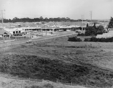
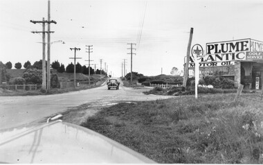 City of Kingston
Photograph - Black and white, c. 1950
... south toward the camera along Warrigal Road which is a sealed... of Warrigal Road and Centre Road in Oakleigh. There is a truck ...This image highlights the rural nature of the area during the 1950s where areas that are now major highways and intersections appear like country roads.Black and white photograph of the intersection of Warrigal Road and Centre Road in Oakleigh. There is a truck travelling south toward the camera along Warrigal Road which is a sealed road. On the right hand side is a Caltex petrol station with a street sign for Centre Road.Handwritten in blue ink on reverse: 2191 Handwritten in red ink on reverse: 72%oakleigh, cars, roads, suburbs -
 Surrey Hills Historical Society Collection
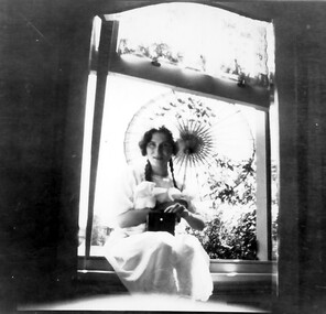
Photograph, Norma Bull portrait
... warrigal road... bought a property at 42 Warrigal Road, Surrey Hills developed... medlow house names warrigal road surrey hills mr ronald richard ...Norma Bull in a window of 'Medlow', 1920s Her brother (Ronald) Richard was a keen photographer and is believed to have taken the photographs of the family and in the grounds of 'Medlow'. Norma Catherine Bull (7 September 1906 – September 1980) was an Australian painter, printmaker and etcher best known for the paintings and sketches she made in Britain during World War II. Norma was the daughter of Richard Joseph Bull (1874-1927) and Catherine Grace Perrier (1884-1972). Her father was the Director of Bacteriology at Melbourne University. Richard and Catherine had 2 children. Norma was born in Hawthorn in 1906 and her brother Ronald Richard was born in Surrey Hills in 1912, where in 1911 Richard bought a property at 42 Warrigal Road, Surrey Hills developed by Colonel William Cairncross, known as ‘Willcyrus’ and renamed ‘Medlow’ by the Bulls. As a child, Norma was a high achiever both intellectually and artistically. She was educated at Fintona, where she matriculated as Dux of the School and winner of an exhibition in French. She won a scholarship to attend the University of Melbourne where she studied French, Zoology, Philosophy, English and History, leading to a Bachelor of Arts in 1929. Following this she studied painting and drawing at the National Gallery Art School for seven years. Whilst most of the students of the 1930s were inspired by Modernism, Norma followed more traditional styles and became known for her etchings and realistic depiction of urban scenes. Her work was strongly influenced by the conservative nature of the National Gallery Art School under Bernard Hall, and she remained a traditionalist all her life. In 1938, she was awarded the Sir John Longstaff Scholarship in Fine Art. This enabled her to travel to England to study at the Royal Academy in London. She arrived in April 1939 and after the outbreak of war, she worked as a volunteer at a First Aid Clearing Station and applied to become a war artist. In 1941, she was given a sketching permit by the War Artists Advisory Committee to record bomb damage in the Bristol area. In 1947, an exhibition of her 205 wartime works entitled “Two Hemispheres”, opened at Australia House in London. Many were acquired for major collections in England including the Victoria and Albert Museum, the Imperial War Museum and the Royal Collection. The “Two Hemispheres” exhibition toured Australia in 1948 and for over twelve months she followed Wirth’s Circus around the country, painting aspects of circus life. From then on she lived at Medlow’, From 1960 she was secretary of the Fellowship of Australian Artists. She was a finalist in the Archibald Prize on 2 occasions and is remembered through a biennial Art Prize, ‘The Norma Bull Portraiture Scholarship’ which is administered by The Victorian Artist’s Society. She continued to paint landscapes and seascapes in her traditionalist style. She had holiday homes at Anglesea and Bright. After she died in September 1980, 31 of her works were bequeathed to Bright Art Gallery. A black and white photograph of a lady holding a sun umbrella and sitting in a window frame.miss norma bull, medlow, house names, warrigal road, surrey hills, mr ronald richard bull -
Glen Eira Historical Society
Plan - Carinya Road, 13, Bentleigh East
... Warrigal Road... drawn plan (70mm x 65mm) of the property. Centre Road Warrigal ...A typed letter dated 20/03/1974 from R T Breen and Co Solicitors to S P Simmonds and Co Real Estate Agents requesting a valuation of the property at 13 Carinya Court South Oakleigh (sic). It includes handwritten notes. The file also includes a copy of a typed letter dated 09/04/1974 to R T Breen containing the valuation of the property at 13 Carinya Court South Oakleigh (sic) by W V Scott. Also included is a handwritten, unattributed document of calculations and measurements for property at Carinya Court, South Oakleigh (sic). The file also includes a photocopy dated 18/03/1974 of the certificate of title for 13 Carinya Court, South Oakleigh (sic). This includes a hand drawn plan (70mm x 65mm) of the property.centre road, warrigal road, mackie road, coatesville state school, architectural features, slorach john henry, slorach christine margaret, wolai avenue, carinya road, carinya court, bentleigh east, oakleigh south -
Whitehorse Historical Society Inc.
Article, New tram link proves popular, 1979
... Road tram extension from Warrigal Road to Middleborough Road... Road tram extension from Warrigal Road to Middleborough Road ...Photocopy of article quoting Keith McCance, state member for Bennetswood commenting on the increase in patronage of the Burwood Road tram extension from Warrigal Road to Middleborough Road.Photocopy of article quoting Keith McCance, state member for Bennetswood commenting on the increase in patronage of the Burwood Road tram extension from Warrigal Road to Middleborough Road. Pressure is being applied to extend to Springvale Road.Photocopy of article quoting Keith McCance, state member for Bennetswood commenting on the increase in patronage of the Burwood Road tram extension from Warrigal Road to Middleborough Road. tram services, burwood road, burwood, mccance, keith -
 Whitehorse Historical Society Inc.
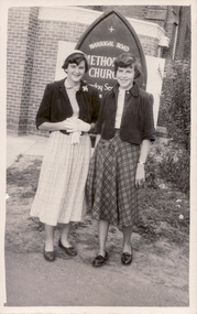
Photograph - B/W Photograph, Gloria Mullens and Valda Sanders
... in front of the Warrigal Road Methodist Church about 1954... of two young women standing in front of the Warrigal Road ...Black and white photograph of two young women standing in front of the Warrigal Road Methodist Church about 1954. On the left is Valda Sanders. On the right Gloria Mullens.mullens gloria, sanders valda -
 City of Kingston
Photograph - Black and white, c. 1963
... Black and white photograph of the intersection of Warrigal... of the intersection of Warrigal Road and Centre Road, South Oakleigh, viewed ...This image depicts the intersection of increasing urbanisation and the rural landscape that once made up the area now known as City of Kingston.Black and white photograph of the intersection of Warrigal Road and Centre Road, South Oakleigh, viewed from the reservoir. In the foreground are paddocks and in the background is a shopping strip, including a petrol station.Handwritten in blue ink on reverse: 2196 Handwritten in red ink on reverse: 100%oakleigh, roads, shopping strip, paddocks -
 Surrey Hills Historical Society Collection
Book, Medlow Garden Survey and Landscape capability study 1983, Oct-83
... warrigal road... rosalie estate warrigal road surrey hills bismarck avenue warwick ...Includes: Plan of Subdivision, Detailed plan, map of garden, Auctioneer's plan for 1854 sale, Botanical plan of Medlow & Landscape history notes. Full title : Medlow Garden survey and landscape capability survey. A report for the National Trust of Australia (Victoria) A report giving a detailed landscape survey of Medlow Garden estate. Includes landscape story, cultural significance, particulars about vegetarian, garden, rehabilitation and plans.Copy of a report giving a detailed landscape survey of Medlow Garden estate. Includes landscape story, cultural significance, particulars about vegetarian, garden, rehabilitation and plans. 38 pages with illustrations.land surveys, medlow garden, bismark estate, rosalie estate, warrigal road, surrey hills, bismarck avenue, warwick avenue, t p payne, (mr) hugh glass, boroondara, (mr) (maj) - cairncross, (mrs) mary jane cairncross, (dr) (mr) richard joseph bull, (mrs) catherine grace bull, (miss) norma bull, (mr) ronald richard bull, medlow -
 Surrey Hills Historical Society Collection
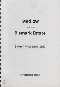
Book, Medlow and the Bismark Estate by Prof. Miles Lewis, 1990
... warrigal road... family medlow varzin avenue warrigal road surrey hills ...The Medlow Estate is a remarkable testimony to the unfulfilled expectations of the land boom of the 1880s to early 1890s. The areas of the former lot 14 or the lines of Varzin Avenue and Friedrichsruh Street where they pass through the present grounds will be conserved as may seem appropriate to exhibit the development of the garden in the Cairncross and Bull periods.The Medlow Estate is a remarkable testimony to the unfulfilled expectations of the land boom of the 1880s to early 1890s. The areas of the former lot 14 or the lines of Varzin Avenue and Friedrichsruh Street where they pass through the present grounds will be conserved as may seem appropriate to exhibit the development of the garden in the Cairncross and Bull periods.bismark estate, rosalie estate, conservation of natural resources, (mr) rex swanson, landform australia, cairncross family, medlow, varzin avenue, warrigal road, surrey hills, friedrichsruh street, (mr) (dr) r j bull, (miss) mary jane cairncross, g n taylor -
 Surrey Hills Historical Society Collection
Book, Medlow Garden Survey and Landscape capability study 1983, Oct-83
... warrigal road... rosalie estate warrigal road surrey hills bismarck avenue warwick ...Includes: Plan of Subdivision, Detailed plan, map of garden, Auctioneer's plan for 1854 sale, Botanical plan of Medlow & Landscape history notes. Full title : Medlow Garden survey and landscape capability survey. A report for the National Trust of Australia (Victoria) A report detailing the landscape survey of Medlow Garden estate. Includes landscape history, cultural significance, particulars about vegetarian, garden, rehabilitation and plans.A report detailing the landscape survey of Medlow Garden estate. Includes landscape history, cultural significance, particulars about vegetarian, garden, rehabilitation and plans. 38 p illland surveys, medlow garden, bismark estate, rosalie estate, warrigal road, surrey hills, bismarck avenue, warwick avenue, t p payne, (mr) hugh glass, boroondara, (maj.) (mr) - cairncross, (mrs) mary jane cairncross, (dr)(mr) richard joseph bull, (mrs) catherine grace bull, (miss) norma bull, (mr) ronald richard bull, medlow, house names, (mr) rex swanson, landform australia -
 Surrey Hills Historical Society Collection
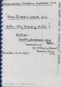
Book, Dorothy Selby (nee Emerson), How green were my hills - my Surrey Hills, September 1979
... warrigal road... emerson (mrs) dorothy emerson warrigal road boundary road st ...A biographical history by Dorothy Selby (nee Emerson) recollecting the people she came into contact with during her time in Surrey Hills from 1915-1937.A4, comb binding, 9 pageshouse names, kookaburra, albany crescent, surrey hills, (miss) dorothy emerson, (mrs) dorothy emerson, warrigal road, boundary road, st stephen's presbyterian church, (mrs) - gillies, (mr) tom ward, dentist, (mrs) - bowen, edwardian style, royal hotel, broughton road, (mrs) - brogan, (mr) - brogan, (mr) - tuckett, tacey's butcher, (mr) james tait, draper, (mr) alfred rose, state savings bank, surrey college, tower house college, balmoral crescent, (mr) - clewett, (mr) percy blood, stenning and holyoak, grocers, (mr) - pell, greengrocer, confectioner, fishmonger, (mr) tommy everon, (miss) beatrice bligh, (mr) - lyons, (mr) - ray, surrey hills station, transport, (ms) kitty mcewan, golfer, taxis, (mr) - collins, surrey hills primary school, (dr) (mr) - forsythe, (dr) (mr) - gandever, windsor crescent, valonia avenue, victoria avenue, (mr) john blogg, progress association, rechabite hall, (mr) claude wardle, (miss) beatrice oakley, empire day, (mr) robert gordon menzies, girl guides, (ms) nancy steele, (ms) hattie steele, (dr) (mr) - blaikie, (mr) - richards, stationmaster, crime, (mr) - cockerill, (mr) horrie breedon, first enlistment, (mr) (rev) brazier, (mr) (rev) - oakes, (mr) (rev) - gillies, (mr) (rev) - mudford, (mr) (rev) - millikan, (mr) (rev) - cockett, (mr) (rev) alfred gifford, (mr) (fr) david gleeson -
Surrey Hills Historical Society Collection
Folder of real estate advertisements, Folders of real estate advertisements (Streets beginning with W), Various
... warrigal road... Road Canterbury melbourne wandsworth road warrigal road warwick ...A4 folders with individual pockets for each property in streets beginning with W located in Surrey Hills and Mont Albert. Folders are ordered by street name and then chronologically by property number. Each property has its own pocket. This may include multiple real estate advertisements collected from sales over time. It may also include copies of any research undertaken by Alan Holt and / or members of the SHNCHC team. These are augmented by cards in the Alan Holt index file and by his property registers of Surrey Hills and Mont Albert.wandsworth road, warrigal road, warwick avenue, warwick court, wellesley street, wells street, west street, weybridge street, wharton street, whitehorse road, whyte grvoe, willcyrus street, wilson street, windsor crescent, windsor lane, wolseley street, wolseley close -
 Surrey Hills Historical Society Collection
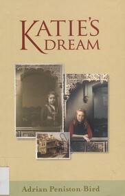
Book, Katie's Dream, 2000
... warrigal road... Road Canterbury melbourne In this novel, Katie begins having ...In this novel, Katie begins having a dream soon after her fathers death. The dream is always the same yet when she awakes up she can never remember what it is about. During the next few months fragments of it start coming back to her. At Medlow, a dilapidated Victorian Villa she encounters a ghostly figure of ten year old Rachel. So begins a strange adventure which takes her back to 1898.In this novel, Katie begins having a dream soon after her father's death. The dream is always the same yet when she awakes up she can never remember what it is about. During the next few months fragments of it start coming back to her. At Medlow, a dilapidated Victorian Villa she encounters a ghostly figure of ten year old Rachel. So begins a strange adventure which takes her back to 1898.On Title Page: With my best wishes /Adrian Peniston-Birdmedlow, house names, warrigal road, (miss) norma bull, surrey hills, (mr) rob adams, (dr) (mr) richard bull, 1889, cairncross family, 1898, willcyrus -
Glen Eira Historical Society
Letter - Rosstown Railway
... Warrigal Road... Establishments Galbally Reserve Plaques Warrigal Road OUT AND ABOUT ...This file contains four items: 1/A black and white photocopy of a letter dated either 07/08/1889 or 09/08/1889, from Robert Lundon to an unidentified recipient discussing an agreement reached between the author – on behalf of the recipient – and Soon Hang Hi in regard, in regards to the allotment known as Webber’s. The agreement is outlined in the letter in what appears to be Chinese characters, and includes the marks of Robert Lundon and Soon Hang Hi. File note from Joy Wu states that the calligraphy is not Mandarin or traditional Chinese. 2/Three sheets of hand-written working notes with information taken from the Victorian Government Gazette on THE ROSSTOWN AND MURRUMBEENA LAND COMPANY LIMITED, THE ROSSTOWN JUNCTION RAILWAY AND PROSPERITY COMPANY LIOMITED, and THE ROSSTOWN JUNCTION, ELSTERNWICK, AND OAKLEIGH RAILWAY COMPANY LIMITED, covering dates between 1887 and 1894. The notes concern meetings and creditors claims relevant to the companies, with reference numbers for the information source. Date and author of the notes are not recorded. 3/A black and white photocopy of the a partial map of the Rosstown Railway and surrounding area, undated. The map includes the names of landholders in the areas of Brighton, Garden Vale and Elsternwick, as well as other railway lines present in the region. 4/A fold-out map and guide of the Rosstown Rail Trail, including a brief general history of Caulfield as well as a more extensive biography of William Murray Ross and the Rosstown Railway. The map marks and describes significant sites along the trail, including photographs of some of these sites, provided by DF Jowett.documents, correspondence, webber’s, lundon robert, chinese characters, ethnic communities, signatures, text, settlements, taxes, fraser john grieves, lovell r.h., price davies, meetings, communication activities, soon hang hi, commercial events and activities, the rosstown and murrumbeena land company limited, victorian government gazette, bulmer richard, parry john, osment henry, shareholders, creditors claims, the rosstown junction railway and property company limited, finch and best, lawyers, the rosstown junction elsternwick and oakleigh railway company limited, cameron w.c., phillips p.d., garden vale, elsternwick, elsternwick railway station, rosstown, rosstown railway, thomas street, bay street, kooyong road, melbourne and brighton railway, hawthorn road, bambra road, caulfield and frankston railway, booran road, grange road, koornang road, murrumbeena road, north road, north road railway station, east brighton railway station, south road, railway routes, railway lines, railways, land transport, murphy j., caulfield, hamilton t.f., dane p., holloway, webb, ailee john, payne t.b., brodie chas, dane john, o’neil h., mccombie john, mcmillane a., smyth c.d., cooper, ebden, landholders, jeffrey j.d., gill j., balcombe a.e., cooper h., mcnab j., white j., sutherland j., greeves a.f.a., newton m.c., chamley f.b., fowler j., inglis p., grant t., stooke j., swanson g., cochrane c., adams e.b., mccombie thas, keyes robert, brighton cemetery, burials grounds and graveyards, war-ein road, were j.b., holland j., mcmahon c., winter t.l.m., dendy henry, mitchell w., jackson s., were j.e., wickham francis dawe, bryant jane, east brighton railway station, railway stations, maps, allotments, land titles, roads and streets, rosstown rail trail, city of glen eira, tourism, trains, tourism information bureaus, tours, pamphlets, elsternwick railway park, oakleigh junction, princes park, ee gunn reserve, packer park, sites, jowett d.f., weickhardt i.g., return to rosstown: railways land sales and sugar beet ventures in caulfield, land sales, walking trails, ross william murray, transport objects, locomotion, walking, cycling, driving, sports, country mansions, people, caulfield john, builders, construction and demolition workers, occupations, careers, professionals, topography, geology, landforms, horticulture, market gardens, primary industry workers, city of caulfield, mood kee, pennington harold, annual general meetings, caulfield town hall, glen eira city council, carnegie, carnegie station, rosstown station, people by circumstance, migrants, sugar beet, sugar beet mill, sugar beet industry, mills, factories, sea beach lines, bent thomas, parliamentary representatives, neville street, miller street, lemann’s swamp reserve, koornang park, cane sugar industry, breweries, rabbit processing plants, health establishments, hospitals, food production establishments, abattoirs, thieves, social problems, vagrants, theft, squatting, financial economics, debt, finance industry, insurance companies, company managers, bentleigh, ross leila, the grange, leila road, wild cherry road, financial trouble, mortgages, gisborne street, archibald street, riddell parade, victoria railways, glen huntly road, clarence street, college street, gladstone parade, parrell street, aileen avenue, seaview street, land subdivisions, dover street, sussex street, landfill, marara road, booran road, woodville avenue, dorothy avenue, ormond park, royal avenue, ormond railway station, oakleigh road, melten avenue, miller street, munro avenue, lord reserve, neerim road, toolambool road, the rosstown hotel, rosanna street, murrumbeena crescent, commercial establishments, the national bank, rosstown road, kangaroo road, poath road, freda street, hughesdale kindergarten, oakleigh council, hughesdale community centre, civic establishments, galbally reserve, plaques, warrigal road, out and about brochures, orion estate -
 Surrey Hills Historical Society Collection
Work on paper - Photograph, Group of young people from Church of Christ, The Avenue, Surrey Hills
... warrigal road... the avenue surrey hills 1934 kirkland union road warrigal road ...This group of young people from the Church of Christ in The Avenue, Surrey Hills are on vacant land owned by John Woodhead. His home 'Kirkland' is in the background. He developed the shops on the SE corner of Canterbury Road and Union Road and donated the land for the Church of Christ and was an elder of the church. Jack Cornhill is identified as back row, 4th from the right. He was the donor's uncle.A black and white photograph of group of people. The girls are wearing skirts that just cover the knee, flat shoes and ankle length socks. Some ar wearing berets. One man on the left appears to be in uniform.church of christ, churches, the avenue, surrey hills, 1934, kirkland, union road, warrigal road, clothing and address, hats, john woodhead, jack cornhill, john cornhill -
Whitehorse Historical Society Inc.
Map, City of Whitehorse, 1/03/1995 12:00:00 AM
... Mullum Creek to the north to Highbury Road and Warrigal Road... and Warrigal Road in the west, to Heatherdale Road in the east. Map ...Map showing streets of the City of Whitehorse from Mullum Mullum Creek to the north to Highbury Road and Warrigal Road in the west, to Heatherdale Road in the east.Map showing streets of the City of Whitehorse from Mullum Mullum Creek to the north to Highbury Road and Warrigal Road in the west, to Heatherdale Road in the east. Prep. by Richard Meloni. Scale 1:15,000Map showing streets of the City of Whitehorse from Mullum Mullum Creek to the north to Highbury Road and Warrigal Road in the west, to Heatherdale Road in the east. city of whitehorse, mullum mullum creek -
 Whitehorse Historical Society Inc.
Article, Electric Tram Capsizes, 1917
... In 1865, Norwood was the area around the corner of Warrigal... of Warrigal Road & Norwood Road(Toorak Road) and had a hotel, bakery ...In 1917, a tram capsized in Norwood (Toorak Road) after gathering too much speed which resulted in the death of a boy and injuries to 18 passengers.norwood road, burwood, toorak road, camberwell, tram services, trams -
 Surrey Hills Historical Society Collection
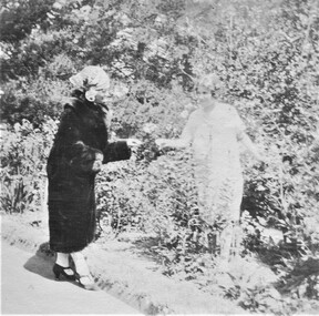
Photograph, Norma Bull and her mother
... ) outdoors. it was probably taken at 'Medlow' in Warrigal Road. Mrs...' in Warrigal Road. Mrs Gentleman was a friend of Norma Bull. miss norma ...Norma Bull and her mother, Catherine Bull (nee Perrier) outdoors. it was probably taken at 'Medlow' in Warrigal Road. Mrs Gentleman was a friend of Norma Bull.A black and white photograph of two ladies in the garden. One lady looks dressed in a fur coat and hat whilst the other is in a sun dress.miss norma bull, mrs catherine bull, miss catherine perrier -
 City of Kingston
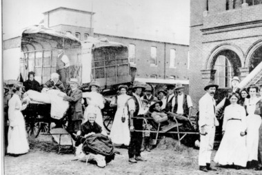
Photograph - Digital image, Black and white, Patients arriving at Melbourne Benevolent Asylum, Kingston Centre, 1911
... Centre, Warrigal Road, Cheltenham, March 1911. 513 patients... Centre, Warrigal Road, Cheltenham, March 1911. 513 patients ...Patients arriving at Melbourne Benevolent Asylum, Kingston Centre, Warrigal Road, Cheltenham, March 1911. 513 patients transferred from North Melbourne. 313 were bedridden.Black and white image of men and women patients arriving at the benevolent asylum with the steps to the building in the background and patients being carried on stretchers from two trucks into the centrePrinted in black text a round white sticker: 82 Hand written in red ink: 52%cheltenham, benevolent asylum, kingston centre -
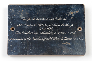 Uniting Church Archives - Synod of Victoria
Commemorative plaque
... "The first Service was held at St Andrew's Warrigal Road... Andrew's Warrigal Road Oakleigh 4-6-1865, This emblem was dedicated ...Small polished metal commemorative plaque mounted on a wood block."The first Service was held at St Andrew's Warrigal Road Oakleigh 4-6-1865, This emblem was dedicated 5-7-1959 and remained in the sanctuary until Church Union 22-6-1977." -
 Whitehorse Historical Society Inc.
Article, Dunstaffnage Hospital, 02/10/1996
... in Warrigal Road, Burwood where they established Dunstaffnage Private... in Warrigal Road, Burwood where they established Dunstaffnage Private ...Photostat of an article from the Whitehorse Post Supplement 2 Oct 1996 about Dunstaffnage Hospitalnon-fictionPhotostat of an article from the Whitehorse Post Supplement 2 Oct 1996 about Dunstaffnage Hospitaldunstaffnage hospital, mccoll alice and jeannie, burwood and district community hospital -
City of Kingston
Photograph - Black and white, 5 January 1984
... ), intersection of Lower Dandenong Road, Warrigal Road, Balcombe Road... and now closed. Mentone Bowl on the corner of Warrigal Road ...Cheltenham and Heatherton are suburbs in the City of Kingston that were originally established as a rural market gardening community. The market gardens, farms and paddocks have gradually been sub-divided into housing and industrial estates and associated infrastructure such as schools and shopping facilities. This aerial image covers a diverse section of the City of Kingston, taking in the suburbs of Cheltenham, Heatherton, Mentone and Parkdale. By 1984, the market gardens of the district have been replaced by housing and factories. The Nylex factory is visible and now closed. Mentone Bowl on the corner of Warrigal Road and Nepean Highway has now been replaced by high rise apartments, another feature of the changing landscape in the City of Kingston. The vacant land now occupied by the Moorabbin Airport Direct factory Outlet (DFO) is also depicted.Aerial photograph of Cheltenham, Heatherton, Mentone and Parkdale within the City of Kingston. The area depicted in the 1984 aerial view includes Centre Dandenong Road and Cheltenham East Primary School (top left), Kingston Heath Reserve (top right), intersection of Lower Dandenong Road, Warrigal Road, Balcombe Road and Nepean Highway (bottom left), Balmoral Drive/McSwain Street Parkdale (bottom right).White text: 3831-179 Lens information [indecipherable] RINGWOOD M/S 7922-3 RUN 16 [Clockface image] 5,300' ASL VIC DLS© 5-1-84cheltenham, heatherton, mentone, parkdale, market gardens, urbanisation -
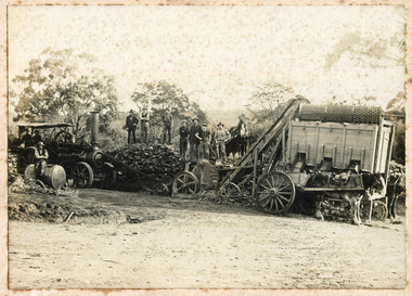 City of Moorabbin Historical Society (Operating the Box Cottage Museum)
Photograph - Photograph, 1908 Excavation commences for the Melbourne Benevolent Society, Cheltenham, 1908 Excavation commences for the Melbourne Benevolent Society, Cheltenham, 1908
... Melbourne premises so was located to a new site at Warrigal Road... was located to a new site at Warrigal Road, Cheltenham. The foundation ...Excavating prior to the building of Melbourne Benevolent Society in Cheltenham. The Centre had begun life in 1850 in Melbourne, as the Victoria Benevolent Asylum to "relieve the aged, infirm, disabled and destitute poor of all creeds and nations and to minister to them the comfort of religion" It outgrew its North Melbourne premises so was located to a new site at Warrigal Road, Cheltenham. The foundation stone was laid in 1909, and the main buildings were completed in 1911. In 1970 the benevolent Asylum was re-named Kingston Centre. The photograph is black and white. It's a photo depicting the excavation prior to the building of Melbourne Benevolent Society in Cheltenham. The photograph shows eleven workers at the excavation site. There are two horses with carriages and a large excavating machine to the right of the photograph. benevolent asylum, benevolent society, cheltenham, train, machinery, men, society, horses, kingston centre -
 Surrey Hills Historical Society Collection
Photograph, Miss Susan Kelsall's school, Canterbury Road, Surrey Hills, 1925
... for her, at 426 Canterbury Road, just west of Warrigal Road... built for her, at 426 Canterbury Road, just west of Warrigal ...Date is approximate. The teacher is presumed to be Miss Susan Kelsall; 3 of the children are identified as: Back row left: Thora Holmes Back row right: Gwen Evans and Betty Austin. Miss Kelsall was registered as a primary and music teacher in 1908. In 1919 she had a school at Wyclif Church in Norfolk Road. From 1924-1930 the school was in the hall, perhaps built for her, at 426 Canterbury Road, just west of Warrigal Road. This was demolished in 1985; a gum tree marked the spot.Black and white photo of a teacher holding a book and 3 rows of children in front of a weatherboard wall with a brick chimney protruding from the wall. The children are not in uniform although a couple of the girls are wearing tunics and all the boys are wearing ties. independent schools, schools, primary education, music, miss susan kelsall, miss gwen evans, miss betty austin, miss thora holmes, mrs betty harvey -
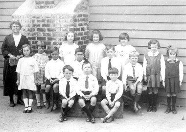
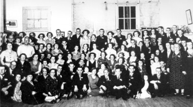 Surrey Hills Historical Society Collection
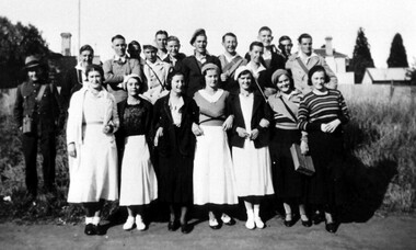
Photograph, Surrey Hills State School, Jubilee Reunion 12 December 1936
... corner of the present Riversdale Road, and Warrigal Road Church... Riversdale Road, and Warrigal Road Church. This photo is at Surrey ...Jubilee Reunion 12/12/1936 School No. 2778 established 1886 at first using a Recreation Hall in Albany Crescent near the corner of Windsor Crescent, Surrey Hills. Surrey Hills was first subdivided into urban blocks in 1883 when the train line to Lilydale was opened. Previously the children of local farmers walked to Balwyn school or to a small school in St. Brigids Church which was on the northeast corner of the present Riversdale Road, and Warrigal Road Church. This photo is at Surrey school via Chatham School archives.Photo of a group of past scholars attending a Jubilee Social on 12 December 1936.On front of photo: Old scholars reunion Jubilee Social Surrey Hills No 2778 / 12.12.361936, clothing and dress, people by circumstance, schools, surrey hills state school, festivals and celebrations