Showing 123 items matching "water conservation"
-
 Eltham District Historical Society Inc
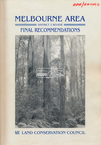
Book, Land Conservation Council, Melbourne Area, District 2 Review: Final Recommendations, 1994
Notices showing the boundary of the area of the review and advising that an investigation was to be carried out were published in the Victoria Government Gazette and in local and other Victorian newspapers in May 1987. A descriptive resources report was published in August 1991. Council received 1,425 submissions and letters following publication of the descriptive report. The Council considered these submissions and published proposed recommendations in April 1993. A further 1,993 submissions were received in response to the proposed recommendations. The Council published its final recommendations in July 1994. A change to legislation in 1989 enabled the LCC to make recommendations for public land within a ‘town’, though cities and rural cities remained excluded from the definition of public land. Timber resources and water quality and yield from timbered catchment areas remained significant issues in Melbourne’s catchments. Recommendations for the Yarra Ranges National Park were based around the closed Melbourne water catchments and adjoining state forest. A recommended Phillip Island State Park based around the penguin reserve was ultimately implemented as the Phillip Island Nature Park.Shire of Nillumbik DPE/Enviro -
 Flagstaff Hill Maritime Museum and Village
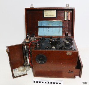
Instrument - Cambridge pH Meter, Cambridge Scientific Instrument Co. Ltd, 9-6-1946
This pH meter was made in 1946 by Cambridge Scientific Instrument Co. Ltd. in London. The company was founded in 1881 and the owner eventually became Horace Darwin, the youngest son of the famous scientist Charles Darwin. It is a portable version that can be used on-site in many different situations. A similar instrument was used by the Chemistry Department of what is now the University of Cambridge. The science of pH measurement began in the 1910s and was further developed in 1926. The pH meter is an electronic scientific instrument used to determine the pH measurements of a solution accurately; the amount of acid and alkaline in it This measurement can have many other applications helping to maintain the appropriate balance for a particular result. For example, it can measure the pH of pharmaceutical medications, soil, swimming pool water and hair shampoos. This Cambridge portable electronic pH instrument was made in 1946 by a company specialising in scientific instruments. It is an early example of much smaller devices used today in many different fields including medicine, and the preservation and conservation of shipwreck artefacts. Flagstaff Hill Maritime Museum and Village's Curator uses a pH meter today in the conservation process of a historic cannon that was recovered from the 1839 wreck of the vessel 'Children'.Scientific instrument, electric Cambridge Portable pH Meter in a polished wooden box with compartments, fold-out doors, and leather carry handle. Includes blue covered Instruction manual with a 'Certificate of Test' inside, and chemicals. Electrodes mounted in compartment. The lid is separate from the base, attached by pins and hinges. A plate inside the lid gives instructions for 'Preparation for Use'. Made by the Cambridge Instrument Company, London, in 1946.Printed on plate: "Cambridge Instrument Co. Ltd, 13 Grosvenor Place, London, S.W.1' Certificate dated: "6-3- 46" (1946)flagstaff hill, warrnambool, maritime museum, maritime village, great ocean road, shipwreck coast, ph meter, cambridge scientific instrument co. ltd, horace darwin, cambridge university, ph balance, scientific instrument, ph measurement -
 Greensborough Historical Society
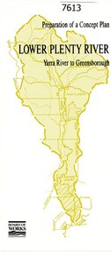
Pamphlet, Melbourne & Metropolitan Board of Works, Lower Plenty River: Yarra River to Greensborough: preparation of a concept plan, 1990
This pamphlet outlines a proposed concept plan for the lower Plenty River, Greensborough to Heidelberg. The plan would focus on preserving and enhancing the aesthetic, recreational and conservation potential of the waterway.2 p., illus., tri-fold pamphlet. 2 copiesplenty river, melbourne water corporation, board of works -
 Kiewa Valley Historical Society
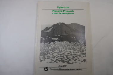
Book - Book - Alpine Area - Department of Conservation, Forests & Lands, Alpine Area / Planning Proposals / a basis for management. 1987
It is the policy of the Government that most of the State's alpine area will be proclaimed as an Alpine National Park, which would complement the Kosciusko National Park in N.S.W.. This is yet to be achieved (1987), however there is a need for sound, efficient and coordinated management based on the area's natural features, values and uses. Planning is proceeding on this basis.Victoria's alpine area is one of the State's most outstanding and spectacular natural areas. It is noted for its diverse plant and animal life, scenery, recreation opportunities and as a water catchment. This country is at the upper end of the Kiewa Valley and the planning for it is of interest to the Kiewa Valley inhabitants.White bound book with green print for title at the top, black & white picture and black print at the bottom for the name of the government authority publishing the book.143 pages with fold out map after page 7. The map is coloured green to indicate the planning area.alpine area, bogong national park, victorian department of conservation forests & lands -
 Ringwood and District Historical Society
Envelope, Packet: Ringwood Area Environment - Land Conservation Council, 150 years of Victoria's Rivers 1989. Heritage Inventory
Historic places, Land Conservation Council relating to past 150 years of Victoria's rivers, streams and water systems; Heritage inventory -
Federation University Historical Collection
Book, Land COnservation Victoria, Land Conservation Council Victoria Report of the North Eastern Area (district 1), 1972, 1972
Yellow and brown soft covered book with brown tapespine. Includes land use, recreation, agriculture, apiculture, vegetation, birds, water physiography, geology, climate, soils, fauna, land systems. Block descriptions include Bethanga, granya, Lawson, Walwa,Pine Mountain, Mittamatite, Elliot, Bunroy, Wabba, Mount Cadgewa, ucyvale, Koetan, Burrowa. Black and white images include Mitta Mitta arm, Corryong, Tallangatta, Lake Hume, Aboriginal rock shelter at Mount Porcupine, Koetong uplands, Mitta Mitta massif, bandicoot, wombat, skink, Flaggy Creek plateau, Walwa, Murray Cod, Thowgla, emu, grasstree, land conservation, north-eastern victoria, environment, landuse, recreation, timber, apiculture, water, upper murray, vegetation, birds -
Federation University Historical Collection
Document - Reports, Martin Westbrooke, Nanya Station
Nanya Station, owned and managed by the University of Ballarat (now Federation University Australia), was purchased with assistance from the Department of Environment and Heritage Government Caring for our Country program. Nanya Station is located in the Scotia country, west of the Darling Ana-Branch in far western New South Wales and consists of the Nanya Western Lands Pastoral Lease 3281 – Perpetual Leasehold Lot 1244 in Deposited Plan 762778, Parish of Winnebaga, County of Tara and part of Lot 1242 County of Windeyer. Nanya is within the tribal area of the Danggali Aboriginal people, a sub-group of the Barkindji. Many Aboriginal sites have been recorded adjacent to major rivers in the region providing evidence that these areas supported a large population. The Scotia region has one of the shortest stock grazing histories of western NSW. Along with five other Scotia properties, Nanya was created as a pastoral lease in 1927. The first European settlement on the land followed exploration of the area by Sturt and Eyre. In 1854, the Lake Victoria lease which encompassed this area comprised 465,000ha.included Scotia blocks 1, 2, 3 and 4, Amoskeag and Winnebaga which formed the area known as the Scotia. It was described as a region of thick mallee scrub, interspersed with bluebush flats and Belah woodland. In the 1920s artesian water was found and the dry Scotia country was surveyed and divided into six Homestead leases allocated by ballot (Withers 1989). All properties were approximately 30,000ha, with a recommended stocking level of 3,000 sheep. Winnebaga (renamed Nanya) was taken up by Gordon Cumming. He initially dug a dam near the southeast corner of the property. A larger ground tank and rudimentary dwelling at the site of the present complex was later established. An adjacent area was cleared and cropped to provide feed for the horses used in digging the earth tanks. The ruins of the original building are located between the shearing shed and Homestead Tank. A cottage was built in the 1930s and a more substantial Red Gum framed homestead in the early 1950s. The lease was held by Mr Gordon Cumming until 1984 when it was purchased by Mr Norm Scadding as an extension to the adjacent lease, Belvedere. It was sold in 1995 to Mr Rob Taylor of Waikerie then in 1999 to BeMax Pty. Ltd., a sand mining company. These last three owners all permitted use of the property by the University for teaching and research. The Centre for Environmental Management at the University of Ballarat had been involved in studies of flora and fauna in western New South Wales since 1988. Studies became concentrated on the Scotia region with its variety of intact ecosystems due to a short pastoral history. Of particular significance is a system of natural salt lakes of which the most extensive is the Scotia Discharge Complex located on Nanya Station. An extensive vegetation survey of the Scotia region Westbrooke et al. 1998) highlighted the significance of the area both in terms of the range of communities in relatively intact condition and the occurrence of species and communities of restricted distribution. Nearly 400 species were recorded of which nine had either not previously been recorded or have restricted distribution in western NSW. Twenty-two plant communities occur on Nanya Station of which two, Halosarcia lylei low open shrubland and Hemichroa diandra/Halosarcia/Frankenia low open shrubland, are dominated by species not previously recorded from NSW. H. lylei and Acacia loderi shrublands are listed as endangered under the NSW Threatened Species Conservation Act. As noted, the area has a relatively short grazing history and, due to the presence of large areas of mallee with a Triodia understorey and restricted water supplies, stocking rates have been low. The diversity of ecosystems in relatively intact condition and extensive areas of old growth mallee made Nanya a highly significant refuge for biological diversity. This factors led to the purchase of Nanya Station by the University of Ballarat in 2004 with the assistance of the Department of Environment and Heritage for the purposes of conservation, research and education. In 2010 the southern paddocks of Nagaella Station (10,000ha.) which lie along the northern boundary, were purchased with the assistance of Lower Murray Darling Catchment Management Authority and added to the Nanya lease to provide complete protection for the communities of the Nanya Discharge Complex and further high quality Malleefowl habitat. Four digital reports documents relating to Federation University's Nanya Station, Western New South Walesnanya station, scotia country, pastoral lease, winnebaga county, darling ana-branch, martin westbrooke, environmental education, nagaella station, lower murray darling catchment management authority, conservation research education, ian gribble, pat prevett, ian henderson, danggali -
Federation University Historical Collection
Report, Read Sturgess and Associates Consulting Economists et al, The Economic Significance of Grampians National Park, 1994 (and other reports), 1990-4
.1) Grampians Surround Strategy, 1990 .2) Tourism and the Grampians Region: A Background Paper, 1990 .3) Grampians Surround Strategy and Discussion Paper, 1991 .4) The Economic Significance of Grampians National Park for the Department of Conservation and Natural Resources, 1994Notes in pencil by Mary Hollick, lecturer in Tourism at the University of Ballarat.victorian tourisim industry, tourism, halls gap, grampians, grampians national park, recreation, water production, bee keeping, arapiles, dunkeld, balmoral, pomonal, wartook, population, agriculture, water supplies, minerals, hamilton, ararat, stawell, horsham, wimmera, koorie heritage, aboriginal heritage, koorie art sites, brambuk, waterways, wannon river, wimmera river, mount william creek, rocklands reservoir, lake lonsdale, lake fyans, lake toolando, cherrypool, mirranatwa, zumstein -
Federation University Historical Collection
Document, Federation University Faculty of Science and Technology Key Capabilities, 2017, 2017
Nine brochures. .1) Archaeology and Heritage .2) Advanced Industrial Analytics (AIA LAboratory) .3) Carbon Technology Research Centre (CTRC) .4) Water Systems .5) Disturbance Ecology .6) Weed Science .7) Sustainable Approches to Environmental Waster .8) Biodiversity Conservation .9) Restoration Ecologyarcheaology, heritage, industrial analytics, carbon technology, water systems, disturbance ecology, weed science, environmental waste, biodiversity conservation, resoration ecology, faculty of science and technology -
Federation University Historical Collection
Book, Jacobs Lewis Vines Architects and Conservation Planners, Historic Sites Survey: Ballarat Study Area, 1980, 1980
This survey was commissioned by the Land Conservation Council, Australian Heritage Commission and the Ministry for Conservation 114 page report on historic sites in the Ballarat region. It includes information on sites, a schexdule of sites, silte selection and designated areas (ie around towns)historic sites, ballarat, wendy jacobs, miles lewis, gary vines, berringa, buninyong, creswick, dunnstown, fiery creek, lal lal, langi logan, cathcart, mount cole, mount egerton, nerrina, gong gong, wombat state forest, railways, explorers routes, early roads, land conservation council, ausralian hertiage commission, department of planning, icomos (burra) charter, nigel lewis, richard aitken, freehold land, public land, langi ghiran, new jubille mine, birthday tunnel mine, pitfield plains, smythesdale, buninyong company, mount clear, mt clear, canadian gully, warrenheip distillery, thomas mitchell, waterloo, trawalla, beaufort, raglan, internment camps, forestry, mining, mining, mt egerton, mary hollick collection, jubilee mine, burra charter, historica areas data form, explorers, egerton company, black horse mine, mt egerton government battery, kaolin mines, anderson brothers, barkstead, anderson's tramway, clarkesdale, berry leads, birthday tunnel mine berringa, warrenheip, australasian company, mount mercer, lanvi-kal-kal, water race -
 Bendigo Historical Society Inc.
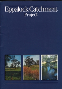
Book - EPPALOCK CATCHMENT PROJECT
27 pages booklet about the Eppalock Catchment Project - A soil conservation success story. Contents: Introduction; Before 1960; Environment; Extension; Planning and works; Implementation; Production; Eppalock-25 years on; What has the Eppalock Catchment Project demonstrated? Also with the book a 4 pages typewritten programme from the Soil Conservation Association of Victoria, Eppalock 25th Celebration, Ecumenical Thanksgiving Service, Sunday 13 October, 1985. at 11.45am - Mia Mia recreation Reserve.civil engineering, water supply, eppalock -
Tatura Irrigation & Wartime Camps Museum
Report, Report on Water Resources of Victoria, 1961
... investigation, conservation and utilization, water distribution... investigation, conservation and utilization, water distribution ...Report used during the 1960's when major improvements were made to the irrigation system in Victoria. Includes investigation, conservation and utilization, water distribution and losses in channel systems. Methods of reducing seepage lossesLight brown, lightweight cardboard cover. Green Spine.relative to salinity, drainage etc, documents, irrigation -
Tatura Irrigation & Wartime Camps Museum
Book, Emergence of Bioregionalism in the MD Basin, 1993
An exploratory essay on he ongoing history of Murray Darling Basin includes legacies, explorations, soil erosion, irrigation divsity, land degradation, change, regionalism, conservation, maps of Vic. NSW and QueenslandGloosy cover, brown marbled scenes from Berri Irrigation Area Reiver Murray, South Australia on back. Maps, water scenes, Pyap Estates on front.murray darling basin, legacies, erosion, degradation, diversity, tatura, murray river, books, rural, industry -
 Villa Alba Museum
Photograph - Exterior cast iron pipe beside louvre window, c.1987
Built for William and Anna-Maria Greenlaw in the early 1880s, and with interiors decorated by the Paterson Bros, Villa Alba remained in private ownership until 1949. From 1950, the house was owned by a number of institutions. By 1984, the Villa Alba Preservation Society had been formed, and three years later, the Mount Royal Hospital granted a 25-year lease to Kew Council. In 2004, the title to Villa Alba was passed by the Victorian Government to The Villa Alba Museum Incorporated. The Museum, at 44 Walmer Street, Kew, is now a cultural institution committed to the collection, study and display of 19th century interior decorative finishes, and the components of 19th and 20th century interior decoration.This is one of a number of historically and aesthetically significant photos of the interiors and exterior of Villa Alba when it was still owned by the Mount Royal Hospital, showing twentieth century accretions and deterioration of the historic fabric of the building. This was a benchmark survey against which future conservation and restoration activities can be measured.In December 1987, Mockridge Stahle & Mitchell Pty Ltd Architects prepared ‘Villa Alba Survey: A Report on the fabric for Mount Royal Hospital’ of which this photograph is a part. Photo of cast iron exterior water pipes located beside a glass louvre window.villa alba museum, conservation photographs, victorian architecture, louvre windows, drain pipes -
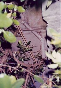 Villa Alba Museum
Photograph - Exterior pipe obscured by foliage, c.1987
Built for William and Anna-Maria Greenlaw in the early 1880s, and with interiors decorated by the Paterson Bros, Villa Alba remained in private ownership until 1949. From 1950, the house was owned by a number of institutions. By 1984, the Villa Alba Preservation Society had been formed, and three years later, the Mount Royal Hospital granted a 25-year lease to Kew Council. In 2004, the title to Villa Alba was passed by the Victorian Government to The Villa Alba Museum Incorporated. The Museum, at 44 Walmer Street, Kew, is now a cultural institution committed to the collection, study and display of 19th century interior decorative finishes, and the components of 19th and 20th century interior decoration.This is one of a number of historically and aesthetically significant photos of the interiors and exterior of Villa Alba when it was still owned by the Mount Royal Hospital, showing twentieth century accretions and deterioration of the historic fabric of the building. This was a benchmark survey against which future conservation and restoration activities can be measured.In December 1987, Mockridge Stahle & Mitchell Pty Ltd Architects prepared ‘Villa Alba Survey: A Report on the fabric for Mount Royal Hospital’ of which this photograph is a part. Photo of cast exterior water pipe party obscured by vegetation.villa alba museum, conservation photographs, victorian architecture, drain pipes -
 Villa Alba Museum
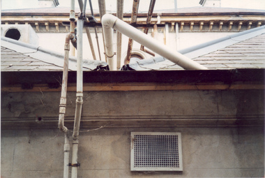
Photograph - Waste water pipes, c.1987
Built for William and Anna-Maria Greenlaw in the early 1880s, and with interiors decorated by the Paterson Bros, Villa Alba remained in private ownership until 1949. From 1950, the house was owned by a number of institutions. By 1984, the Villa Alba Preservation Society had been formed, and three years later, the Mount Royal Hospital granted a 25-year lease to Kew Council. In 2004, the title to Villa Alba was passed by the Victorian Government to The Villa Alba Museum Incorporated. The Museum, at 44 Walmer Street, Kew, is now a cultural institution committed to the collection, study and display of 19th century interior decorative finishes, and the components of 19th and 20th century interior decoration.This is one of a number of historically and aesthetically significant photos of the interiors and exterior of Villa Alba when it was still owned by the Mount Royal Hospital, showing twentieth century accretions and deterioration of the historic fabric of the building. This was a benchmark survey against which future conservation and restoration activities can be measured.In December 1987, Mockridge Stahle & Mitchell Pty Ltd Architects prepared ‘Villa Alba Survey: A Report on the fabric for Mount Royal Hospital’ of which this photograph is a part. Photo of numerous pipes, all installed during the period when the house was owned by the Royal Women's Hospital as a home for nurses (1950-1974). The pipes extended from a bathroom installed at the end of the first floor hall, running along the box gutter to the rear of the building. [The pipes were removed in subsequent restorations].villa alba museum, conservation photographs, victorian architecture, drain pipes, waste water -
 Villa Alba Museum
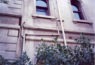
Photograph - Exterior pipe work, c.1987
Built for William and Anna-Maria Greenlaw in the early 1880s, and with interiors decorated by the Paterson Bros, Villa Alba remained in private ownership until 1949. From 1950, the house was owned by a number of institutions. By 1984, the Villa Alba Preservation Society had been formed, and three years later, the Mount Royal Hospital granted a 25-year lease to Kew Council. In 2004, the title to Villa Alba was passed by the Victorian Government to The Villa Alba Museum Incorporated. The Museum, at 44 Walmer Street, Kew, is now a cultural institution committed to the collection, study and display of 19th century interior decorative finishes, and the components of 19th and 20th century interior decoration.This is one of a number of historically and aesthetically significant photos of the interiors and exterior of Villa Alba when it was still owned by the Mount Royal Hospital, showing twentieth century accretions and deterioration of the historic fabric of the building. This was a benchmark survey against which future conservation and restoration activities can be measured.In December 1987, Mockridge Stahle & Mitchell Pty Ltd Architects prepared ‘Villa Alba Survey: A Report on the fabric for Mount Royal Hospital’ of which this photograph is a part. Photo of numerous pipes, all installed during the period when the house was owned by the Royal Women's Hospital as a home for nurses (1950-1974). The pipes extended from the roof and from rooms used as washrooms on the first floor.villa alba museum, conservation photographs, victorian architecture, drain pipes, waste water -
Creswick Campus Historical Collection - University of Melbourne
Document, 1975-1985
Results register. Certificate of Applied Science (Conservation and Resource Development) Units.Document -
Whitehorse Historical Society Inc.
Document, Mullum Mullum Valley
A laminated poster depicting an original water colour by Christine Bever, June 1999.A laminated poster depicting an original water colour by Christine Bever, June 1999, produced by the Australian Conservation Foundation of the Mullum Mullum Valley.A laminated poster depicting an original water colour by Christine Bever, June 1999. mullum mullum valley, conservation -
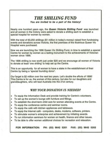 Queen Victoria Women's Centre
Flyer, The Shilling Fund: you are invited to be a part of the history!, c. 1996
Used as a small poster/flyer as there are remnants of sticky dots on the back. Unknown location. Laminated cream paper. Black ink. water mark on page stating 'conservation' and the recycled sign below.fundraising, historical site -
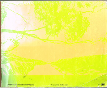 Otway Districts Historical Society
Book, Land Conservation Council, Report on the Corangamite Study Area, May 1976
The Report describes and assesses the natural resources of public land in the Corangamite study area, and provides a factual basis on which members of the community may base their submissions to the Council.Report on the Corangamite study area. Land Conservation Council. Melbourne; Land Conservation Council; May 1976. x, 310 p.; illus, maps (separate). Soft cover.land conservation council; corangamite; geology; physiography; climate; water resources; soils; vegetation; fauna; -
 Bendigo Historical Society Inc.
Document - HERITAGE REPORT: FORMER POLICE STATION AND QUARTERS: CALIFORNIA GULLY
Seventeen page Heritage Place Report on the Former California Gully Police Station at 15 Thorpe Street, California Gully. It is the former police station and quarters, former timber stables and timber cottage residence demolished and horse paddock on separate title. Report includes a Statement of Significance, Place History (History of the Area), Policing California Gully Goldfields, History of the Buildings, Chronology of Ownership, Rate Books 1858, - 1867 - 1868, 1895 Borough of Eaglehawk Rates, 1922 Voters Roll, 1952 & 1962 Sands & McDougall Directory Thorpe St California Gully, Comparable Examples, Secondary Sources, Description Conservation Policy Guidelines (Specific), Physical Conditions, Physical Description 1, Map of Early Photo Location, Bendigo Parish Plan circa 1870, Certificate of Title 1950 & 1960. Pge 14 has plans, maps and an aerial photo of 15 Thorpe Street. Page 15 has an aerial photo of 15 Thorpe Street, California Gully with Allotment Size. Page 16 & 17 has photos.heritage, heritage report - former police station and quarters - california gully, city of greater bendigo, wilson & ass, butler, amanda jean, johnson reef shafts no 1 & 2, rose of denmark, princess dagmar, bendigo amalgamated goldfields company, captain frederick standish, royal irish constabulary, e thorpe, campbell, taylor, watson, brown, hosken, mckowne, mcqualter, parker, hicks, eaglehawk municipal council, victorian police force, d bannear, historic mining sites in the sandhurst eaglehawk and raywood mining divisions, department of conservation and natural resources, joshua thorpe, thorpe & co, johnson & co, william thorn, michael thomas, james murdock, edward c brown, francis youlden, gold escort, water police, mounted police, city police (melbourne), geelong police, gold fields police, rural bench constabulary, the people's force, robert haldane, n wild, streets of the borough of eaglehawk, police registration act, william henry mitchell, camp hotel, j o c nieman, j m catarach, g w hosken, margaret hosken nee mckown, majorie alice mcqualter, kellie anne mcqualter, adam joseph doolan, mr hicks, sands & mcdougall, hill george, meeking howard, mcewan frank a, jinks stanley, mccaig mrs eleanor, gordon john l, mcqualter mrs adeline, maher william l, raynor robert, flack john p, whitehead miss a, sang george t, linddsay john p, dyer henry, jackman george a, tibbetts mrs s a, hosken mrs margaret winifred nee mckowne, chaplin frank w, wilson c e, wright george, miller g a, sheyhill basil hugh, marshall r, miles j h, parker w b, barkla w g, nicholls les, cartledge clifford william, cole charles basil, farmers citizens trustees co, bev hanson -
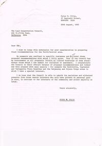 Bendigo Historical Society Inc.
Document - PETER ELLIS COLLECTION: LETTER, 20th August, 1980
Letter (11 Pages) from Peter N Ellis to the Land Conservation Council. Letter refers to proposed State parks - Kamarooka State Park and Whipstick State Park. other areas mentioned are the Wellsford Forest, Mandurang Forest, Lockwood Forest, Waanyaraa, Fryerstown, Whipstick Hill (Flagstaff Hill) and Black Rock. Other areas are Wellsford/Axedale Forest, Sugarloaf Range, Mandurang Forest, Main Coliban Channel, Lockwood Forest, Tarnagulla/Dunolly Forest, Fryerstown, Seven Sisters (between Huntly and Goornong). Plant and tree life in each area is mentioned including the cutting of eucalypt for the production of Eucalyptus oil.person, individual, peter ellis oam, peter ellis collection, land conservation council, kamarooka state park, whipstick state park, eucalyptus oil production, fncv victorian naturalist, d j paton, bendigo field naturalists club, wellsford forest, mandurang forest, main coliban channel, lockwood forest, waanyaras, fryerstown, whipstick hill (flagstaff hill), parish of neilborough, old underground water race, puddling machine, srwsc -
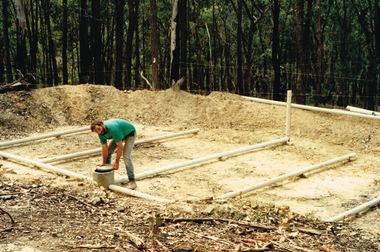 Round the Bend Conservation Co-operative
A member building a transpiration bed to recycle the household water. This is a way of concentrating absorption trenches in a confined area, managing waste water and containing the soil disturbance to the site
-
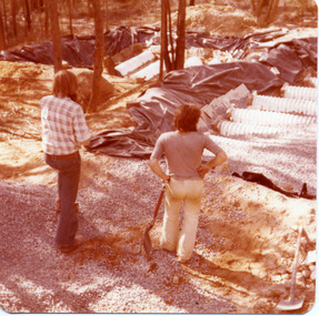 Round the Bend Conservation Co-operative
In a transpiration bed realn drains, screenings, sand and soil filter the water which is then expired by the plants
-
 National Wool Museum
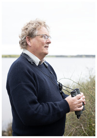
Photograph - Portrait of Dr John Newman, Nicole Marie, 2021
Thousands of volunteers work tirelessly to conserve and protect the environment of Geelong and the Bellarine. Their work often goes unnoticed. In 'The Work of Nature' the National Wool Museum and the Environment Department at the City of Greater Geelong worked with photographer Nicole Marie to showcase the significant contribution of environment volunteers in our region. Each of the eight people showcased in these portraits were nominated by their peers and members of the community for their significant contribution to conserving and protecting the environment. Dr John Newman - Geelong Field Naturalists Club Over almost twenty years John Newman has organised large groups of volunteers to conduct surveys across Geelong and the Bellarine for shorebirds and waterbirds. Understanding and collecting important environmental data helps in the effort to preserve important sites, much of this data is collected by volunteers. The information collected in Geelong and the Bellarine also forms part of national and international datasets that helps in understanding global patterns of migratory birds, such as sharp-tailed sandpiper, red-necked stint and the critically endangered curlew sandpiper. The data collected at the Moolap Saltworks (since 1981) and co-ordinated by John since 2003 highlighted the importance of this site for these three species and played a crucial role in protecting the area as a conservation site. Photo at Taits Point, Lake Connewarre Wildlife Reserve by Nicole Marie.Image showing an environmental portrait of a man holding binoculars with a water landscape in the background.environment, conservation, portraits, geelong, nature, exhibition, work of nature, geelong nature forum, volunteers, lake connewarre -
 Federation University Herbarium
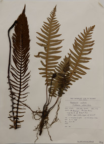
Alexander Clifford Beauglehole, Blechnum nudum (Labill.) Mett. ex Luerss, 6/11/1978
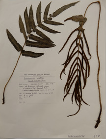
Cliff Beauglehole was an orchardist at Portland, Victoria, who throughout hislife took an intense interest in the plants of Victoria. Over his lifetime he collected 90,000 plant specimens as part of a comprehensive study of Victoria's plants and wrote thirteen books under the heading The Distribution and Conservation of Vascular Plants in Victoria, each written to cover the 13 study areas of the Victorian and Conservation Council.A mounted botanical specimen.beauglehole herbarium, herbarium specimen, botany, herbarium, plant science, plant specimen, field naturalists' club ballarat, federation university herbarium, blechnum nudum, fishbone water-fern, blechnaceae, fern -
 Federation University Herbarium
Plant specimen, Alexander Clifford Beauglehole, Blechnum wattsii Tindale, 6/11/1978
Cliff Beauglehole was an orchardist at Portland, Victoria, who throughout hislife took an intense interest in the plants of Victoria. Over his lifetime he collected 90,000 plant specimens as part of a comprehensive study of Victoria's plants and wrote thirteen books under the heading The Distribution and Conservation of Vascular Plants in Victoria, each written to cover the 13 study areas of the Victorian and Conservation Council.A mounted botanical specimen.beauglehole herbarium, herbarium specimen, botany, herbarium, plant science, plant specimen, field naturalists' club ballarat, federation university herbarium, blechnum wattsii, hard water-fern, blechnaceae, fern -
 Phillip Island Conservation Society Inc.
Work on paper - Photocopy of newspaper cutting, "PENGU/ CHOK/ IN/ OIL" (meant to be : "Penguins choke in oil"
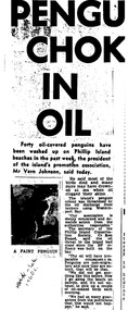
With the establishment of the large heavy industrial zone at Hastings in the late 1960s, which included the BP oil refinery using the Port of Hastings at the north-western arm of Western Port, a number of environmental problems predicted by both scientists and conservationists arose. The main shipping channel on the western arm of Western Port was dredged, causing suspended particles affecting seagrass beds. With inadequate regulation around discharge of bilge water within the bay, and oil spillage, oil pollution affecting both seabirds and coastal areas was not uncommon. This report of 40 penguins actually known to have been killed by an oil spill event was typical of reports at the time. The 2 men quoted – Vernon Johnson and Ken Pound – were well known conservationists. Vernon and his wife Nora owned the Kingston Gardens picnic and zoo business where they cared for many injured wildlife. Ken was a Phillip Island counsellor for a few years, and instrumental in the establishment of the Phillip Island conservation Society. He also contributed various documents and newspaper cuttings to this archive.This article is significant for being a record of an exact number of penguins found dead from oil spill pollution in Western Port. Also as a record of conservationists in the early years of community and environment movements both locally and in Australia. The article further gives evidence of linking tourism with wildlife.Photocopy of newspaper cutting. Black print with very dark black and white photo of Fairy (Little) Penguin. Poor reproduction due to older photocopy machine.(indecipherable) - late/1960s.little penguins, fairy penguins, eudyptula minor, penguin behaviour, phillip island tourist attractions, phillip island conservation society, oil spills, bp refinery hastings, port of hastings, western port, marine pollution, oil tankers, vernon johnson, ken pound, phillip island promotion association -
 Phillip Island Conservation Society Inc.
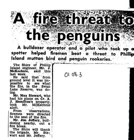
Work on paper - Photocopy of newspaper cutting, Wonthaggi Express or Powlett Express newspaper, "A fire threat to/the penguins", 28.01.1965
The article describes a fire incident which took place in January 1965 at Swan Lake, a water reserve at the entrance to Summerland Peninsula, Phillip Island. Due to an extremely heavy infestation of gorse (noxious weed) and natural tea tree scrub, along with poor vehicle access, the volunteer fire fighters could apparently not gauge the extent of the fire. A light plane operator visiting Cr Arthur Hamilton nearby was able to fly Phillip Island Shire Engineer, Jock McKechnie, over the lake to better direct the fire fighters. Swan Lake has many Bunurong Aboriginal middens and short-tailed shearwater rookeries, and, being not far from the Penguin Parade, a fire there posed a direct threat to the birds. The article is significant because it indicates the vulnerability of the Summerland Peninsula reserves to fire, the way the Shire Engineer, local bulldozer contractor and volunteer fire fighters tackled the fire outbreak. photocopy of newspaper cutting. Dark copying at top. Double column heading. Single column black text on white paper28-1-65 EXswan lake phillip island, summerland peninsula, bunurong aboriginal middens, short-tailed shearwaters, mutton birds, little pengiuns, penguin parade, jock mckechnie, cr arthur hamilton, fire fighters, , max stewart, jim jeffery