Showing 393 items matching "water reserve"
-
 Bendigo Historical Society Inc.
Document - KANGAROO FLAT GOLD MINE COLLECTION: MEMO WESTERN MINING CORPORATION TO D.F. WRIGHT AND R. WRIGHT
... within Shire Spring Gully, area outside water reserve... Spring Gully, area outside water reserve, classified ...Memorandum 29th February 1984 from Western Mining Corporation to T.E. Johanson, subject 'Bendigo'. Consent to drilling proposals and exploration licence for : Prince of Wales, Marong portion, bushland reserve and Eaglehawk portion Birds, Crown Land within Shire Spring Gully, area outside water reserve, classified as a Regional Park. In each of these categories exploration and mining is a permitted use.bendigo, gold mining, drilling proposals, bendigo, goldmining, drilling, t.e. johanson, planning permits, d. evans, r. wright. -
 Stawell Historical Society Inc
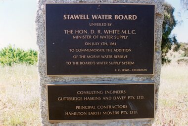
Photograph, Plaques at "Moray" 1984 -- Coloured
... the Addition of the Moray Water Reserve To the Board's Water Supply... the Addition of the Moray Water Reserve To the Board's Water Supply ...Coloured Photo - Plaques at "Moray" 1984Stawell plaques on a square stone.Stawell Water Board unveiled by The Hon. D. R. White M.L.C. Minister of Water Supply on July 4th, 1984 To Commemorate the Addition of the Moray Water Reserve To the Board's Water Supply System E.C. Lewis - Chairman Consulting Engineers Gutteridge Haskins and Davey Pty. Ltd. Principal Contractors Hamilton Earth Movers Pty. Ltd.grampians water supply -
 Bendigo Historical Society Inc.
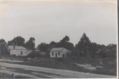
Photograph - Nell Gwynne Gold Mine site, 1934
... The Nell Gwynne mine site was within the Spring Gully Water...The Nell Gwynne mine site was within the Spring Gully Water ...The Nell Gwynne mine site was within the Spring Gully Water Reserve, north west of the reservoir near Diamond Hill Road. An abridged prospectus for the Nell Gwynne (B.M.L.) No Liability, was published in the Sun News Pictorial on 7th June 1934, page 26 (Advertising).https://trove.nla.gov.au/newspaper/article/277316940?searchTerm=napoleon%20bmlSignificant to mining history of Bendigo.Black and white photograph of two weatherboard houses in bush setting. Gravel road in foreground. Written in pencil on back of photograph in pencil: 'Nell Gwynne 25.9.34'nell gwynne gold mine -
 Port Melbourne Historical & Preservation Society
Document - Receipt, Melbourne Water Supply, 1880s
... gallons of water to ornamental reserve, Nott Street, Port... gallons of water to ornamental reserve, Nott Street, Port ...Receipt from Melbourne Water Supply for supply of 47,000 gallons of water to ornamental reserve, Nott Street, Port Melbourne 1880ssport - lawn bowls, parks and gardens, port melbourne bowling club, henry norval edwards, michael tarver quinn, local government - borough of sandridge -
 Ballarat Heritage Services
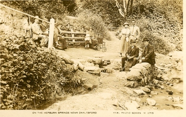
Photograph - Photograph - Colour, Locarno Spring at Hepburn Springs
... the waters' at Locarno Mineral Water Spring, Hepburn Springs Reserve. ...' at Locarno Mineral Water Spring, Hepburn Springs Reserve. Locarno ...Black and white image of a number of people 'taking the waters' at Locarno Mineral Water Spring, Hepburn Springs Reserve. hepburn springs, locarno spring, hepburn springs reserve -
 Eltham District Historical Society Inc
Journal - Newsletter, Newsletter, No. 280 February 2025
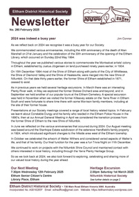
... Life On The Chain by Ian Bryant • Eltham Water Reserve • My... Life On The Chain by Ian Bryant • Eltham Water Reserve • My ...Contents: • 2024 was indeed a busy year by Jim Connor • Our next meeting –7:30pm Wednesday 12th February 2025 – Homeland: Stories from Afar; Liz Pidgeon YPRL • Our next excursion – Saturday 1st March 2025 – Nillumbik Historical Society • Convict Life On The Chain by Ian Bryant • Eltham Water Reserve • My Schooldays at Killeavey by Jenny Ellis • Margot Knox by Alistair Knox • Margot Knox 1931 - 2002 by Gwen Ford • Men’s Sheds by Jim Connor • Little Eltham Heritage Walk brochure • Early Eltham • Hurstbridge Rail Line Electrification by Richard Pinn The Shire of Eltham Historical Society was formed in October 1967. The first newsletter of the Society was issued May 1978 and has been published continuously ever since on a bi-monthly basis. With the cessation of the Shire of Eltham in late 1994, the Society's name was revised to Eltham District Historical Society and this name first appeared with issue No. 103, July 1995. The collection of the Society's newsletters provides a valuable resource on the history of the Society's activities, office bearers and committee members, guest speakers and subjects of historical interest pertinent to the former Shire of Eltham and the Eltham District.A4 newsletter distributed to members (Digital and A4 photocopy)newsletter, eltham district historical society -
 Stawell Historical Society Inc
Photograph, Indigenous or First Nations People at Carrs Plains 1874 Richardson River Tribe
... of camping & water reserve near surveyed Bismarck township... of camping & water reserve near surveyed Bismarck township ...Photo taken at Carrs Plains in 1874 of Indigenous or First Nation People outside a wood and bark hut. In 1861, William Dennis of Carrs Plains Station, a staunch Methodist became Honorary, Aboriginal Protector for the area. One of his main tasks to give Government supplied food and clothing to the Aboriginals. Many district, remaining Aborigines became based at Carrs Plains, and their dead were buried in a cemetery on the station. The cemetery is show on survey map of Wirchilleva Borough, in corner of camping & water reserve near surveyed Bismarck township. In a Protector's report 1869, Dennis wrote that only one male worked regularly on the property, a Bullock driver.Black and white photograph of a wood and bark hut with a group of men, women and children out the front. Richardson River Tribe.Anthony & Lubra, Donald & Affie my ? Herbal? Black Billie Great Rider, Kitty Supulants? Lubra Jonny Callaghan Jr., Four? Supulant? Harry, Blind Tommy & Lubra, 1874 Reproduction rights reserved Copied by State Library of Victoriastawell aboriginal portrait -
 Bendigo Historical Society Inc.
Document - CONNELLY, TATCHELL, DUNLOP COLLECTION: LEGAL PAPERS, 1886
... re O'Neills application and water reserve at Axedale.... re O'Neills application and water reserve at Axedale ...Document. Connelly, Tatchell & Dunlop - Legal Papers. 1 - 1886 - Letter from Gibbins Alice, Inglewood re Morrow. 2 - 1886 - Post Office Telegraph from Jones L J, Kerang re Hughes. 3 - 1886 - Post Office Telegraph from Irving Jas, Kerang. 4 - 1886 - Letter to Wood W Esqre, Town Clerk, Eaglehawk and return from Wood Wm. 5 - 1886 - Letter from Bennett & Co re Hawthorne & Brady. 6 - 1886 - Letter from Bennett & Co re Gibbins v Morrow. 7 - 1886 - Letter from Bennett & Co re Webb & Holmes & White. 8 - 1886 - Letter from Secretary for Mines and Water Supply re O'Neills application and water reserve at Axedale.cottage, miners, connelly, tatchell & dunlop, gibbins alice, jones l j, hughes, irving jas, wood w esqre, bennett & co, hawthorne, brady, gibbins, morrow, webb, holmes, white, mines and water supply, o'neill -
 Phillip Island Conservation Society Inc.
Work on paper - Photocopy of newspaper cutting, Wonthaggi Express or Powlett Express newspaper, "A fire threat to/the penguins", 28.01.1965
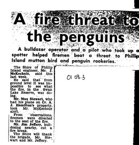
... in January 1965 at Swan Lake, a water reserve at the entrance... which took place in January 1965 at Swan Lake, a water reserve ...The article describes a fire incident which took place in January 1965 at Swan Lake, a water reserve at the entrance to Summerland Peninsula, Phillip Island. Due to an extremely heavy infestation of gorse (noxious weed) and natural tea tree scrub, along with poor vehicle access, the volunteer fire fighters could apparently not gauge the extent of the fire. A light plane operator visiting Cr Arthur Hamilton nearby was able to fly Phillip Island Shire Engineer, Jock McKechnie, over the lake to better direct the fire fighters. Swan Lake has many Bunurong Aboriginal middens and short-tailed shearwater rookeries, and, being not far from the Penguin Parade, a fire there posed a direct threat to the birds. The article is significant because it indicates the vulnerability of the Summerland Peninsula reserves to fire, the way the Shire Engineer, local bulldozer contractor and volunteer fire fighters tackled the fire outbreak. photocopy of newspaper cutting. Dark copying at top. Double column heading. Single column black text on white paper28-1-65 EXswan lake phillip island, summerland peninsula, bunurong aboriginal middens, short-tailed shearwaters, mutton birds, little pengiuns, penguin parade, jock mckechnie, cr arthur hamilton, fire fighters, , max stewart, jim jeffery -
 Federation University Historical Collection
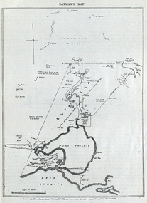
Image, Batman's Map of Port Phillip
... reserve, fresh water... Tract), a township reserve, open plains, public common reserve ...Scanned from "The Old Pioneers' Memorial History of Melbourne From the Discovery of Port Phillip to the World War". It is a facsimile map from the House of Commons Reports of Committee.John Batman's map of Port Phillip showing Dutigalla (Batman's Tract), a township reserve, open plains, public common reserve, fresh water"A tract of country [called?] by the native chief of Southern Ausralia to be John Batman 6th June 1935."port phillip bay, john batman, melbourne, iramoo, r. sarsh, river sarsh, river batman, yarra river -
 Federation University Historical Collection
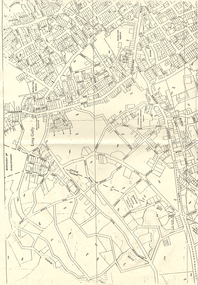
Map, Ballaarat Gold Field, 1861, 21/10/1861
... , waterways, mines, churches, schools, water races, and garden..., water races, and garden reserves. It was compiled and drawn from ...A party of surveyors camped by Yuille's Swamp (later Lake Wendouree) and surveyed the countryside for a map to be produced by the Geological Survey of Victoria. In November 2004 the Central Highlands Regional Library presented a special edition of 200 copies of the 1861 map reproduced from a copy in their collection. Original geological map of Ballarat showing property, waterways, mines, churches, schools, water races, and garden reserves. It was compiled and drawn from the surveys of Mining Surveyors Davidson, Fitzpatrick and Cowan.Compiled & Drawn from the Survey of Mining Surveyors Davidson, Fitzpatrick and Cowan & the Plans in the Surveyor General's Office by J. Brahe, 21st October 1861. R. Brough Smyth, Secretary for Mines. The Honourable J.B. Humffray, M.L.A. Commr of Mines.ballarat, map, davidson, robert brough-smyth, fitzpatrick, cowan, yuille's swamp, public garden reserve, manure depot, black hill, ballarat east, old post office hill, pennyweight hill, claytons hill, golden point, mining, railway, cricket ground, swamp creek, cemetery, sludge reserve, bakery hill, gaelic church, juvenile reformatory, orphanage, specimen hill, eureka lead, cattle yard hill, dalton's flat, chinese village, poverty hill, railway reserve, little bendigo diggings, pound reserve, allied armies, flour mill, agricultural reserve, marsh, survey reserve, survey corps, white flat, yarrowee, yarrowee creek, brache, j. brache, survey, ballaarat gold field 1861 -
Bendigo Historical Society Inc.
Map - HARCOURT : COUNTY OF BENDIGO, 23-3-10
... with Barkers Creek Reservoir. Victorian Water Supply Reserve, Mt.... Victorian Water Supply Reserve, Mt. Alexander State Forest. Three ...Map. County of Bendigo, County of Talbot, Sutton Grange, Ravenswood, Walmer, Faraday, Castlemaine, Axe Creek, Barkers Creek, Melbourne to Echuca Railway, Victorian Water Supply in Connection with Barkers Creek Reservoir. Victorian Water Supply Reserve, Mt. Alexander State Forest. Three areas reserved for Sericulture (Silkworms). Photo-Lithographed at the Dept. of Lands and Survey, Melbourne by T.F. McGauran 23-3-10. Price 1/-. (number 101 in map cupboard 1)T.F. McGauranmap, bendigo, harcourt -
 Ringwood and District Historical Society
Map, Plan of Country Lands in the Parishes of Nunawading Ringwood and Scoresby - circa 1855
... ", and location of water and firewood reserves.... with stringy bark", and location of water and firewood reserves. Plan ...Blueprint copy of Survey Map detailing original Selectors' names and property locations. List of Parish map references including property bearings, distances in Links, and markings on trees. Descriptive remarks include areas marked "Farmer's Common", "Poor soil thickly/moderately timbered with stringy bark", and location of water and firewood reserves."Surveyed and plotted by N.M. Bickford, Superintendant of Mr. Hodgkinson's Field Party". "The land comprised in this survey is of inferior quality, moderately undulating, and thickly wooded. It is watered by Dandenong Creek and Deep Creek." Inset map showing location of (*proposed) cemetery on southern corner of Lillydale Road from Melbourne and Sawmill Road, later Mount Dandenong Road. (*Cemetery did not eventuate.) -
 City of Moorabbin Historical Society (Operating the Box Cottage Museum)
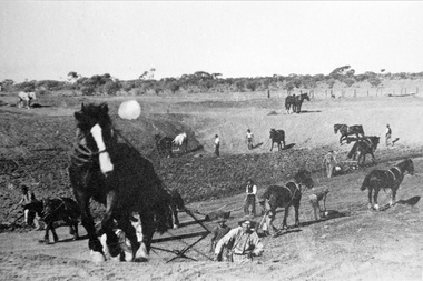
Photograph, Black & White Horse drawn scoops earthwork in Moorabbin Shire c1900, c1900
... , establishing sizeable dams for important water reserves for community... and early 1900's, establishing sizeable dams for important water ...The, horse drawn metal scoop ,guided by a man, was used to clear earth for road making. Well before the introduction of motorised, mechanical graders and trucks the painstaking, labour-intensive work was undertaken by large teams of sturdy men using strong horses such as the draught horse. Roads were needed by the market gardeners to transport their produce to market. Later as the heavy wagon loads continually caused ruts and general degradation of the roadways a Plateway system was installed so that the wagon wheels could roll along the rails thus protecting the roadways. August 31st 2021 Ron Nash, from WA, informs us "The men and horses pulling earth scoops in the photo are not moving earth for road making - they are excavating an "earth tank", or dam, as described in common nomenclature today. This skill was known as "tank sinking", and tank sinkers were active in many rural and remote areas in the 1800's and early 1900's, establishing sizeable dams for important water reserves for community and farm and railway use. With the advent of mechanised equipment such as bulldozers, the trade of tank sinking was still carried out, but on a faster basis. I am a former tank sinker and earth moving contractor, now long retired." Early settlers in Moorabbin Shire had to build the roads, plateways, drains, as the settlement of the land, in Dendy's Special Survey 1841 Brighton, spread and market gardeners need to transport their produce to market. Their most valuable possession was the draught horse that was used for ploughing, drawing carts and these scoops.Black & White photograph showing many horses pulling metal scoops guided by men to move earth for road making in Moorabbin Shire c 1900Back Handwritten Informationplateway, roadworks moorabbin shire, draught horses, metal scoops, paviers, box alonzo, smith j l; chaff cutter, horse drawn carts, toll gates brighton, motor cars 1900, steam engines, early settlers, bentleigh, mckinnon, parish of moorabbin, city of moorabbin, county of bourke, moorabbin roads board, shire of moorabbin, henry dendy's special survey 1841, were j.b.; bent thomas, o'shannassy john, king richard, charman stephen, highett william, ormond francis, maynard dennis, market gardeners, vineyards, orchards -
 Bendigo Historical Society Inc.
Document - PETER ELLIS COLLECTION: A GUIDE FOR DRIVERS ON THE WHIPSTICK TOUR
... (shown in different colours) Water Reserve and Roads. Noted... (shown in different colours) Water Reserve and Roads. Noted ...A Guide for Drivers on the Whipstick Tour. First page gives assembly area, driving in convoy and negotiating water or boggy patches across the road. Amended written at the end of the page. Directions with mileage and items of interest for the tour on Sunday September 9th (no year). A Whipstick Map 1971 showing State Forest, Crown Lands, Uncleared Mallee - Private (shown in different colours) Water Reserve and Roads. Noted are Flora and Fauna - Plants, Birds & Mammals, and areas of State Forest and Southern State Forest with Mallee Scrub area noted. Also State Forest & Crown Lands Total Area and a map scale. The Bendigo Whipstick mentions area, suggestions of where the name Whipstick came from, shrubs and flowers with their flowering times, descriptions of some of them and some information on the Mallee Fowl. The Eucalyptus Oil Industry paragraph mentions the beginnings of the industry. Mentioned are the different uses of oils (perfumery, industrial and medicinal) and the different species of eucalypt used for each and various products. Also notes on the growing, harvesting and refining of eucalyptus. P Ellis at the end of the page. The next two and a half pages mentions reserves, and at the end acknowledgements. Includes a spare copy of 'The Bendigo Whipstick' by P Ellis.bendigo, history, early bendigo, peter ellis collection, a guide for drivers on the whipstick tour, the whipstick 1971 map, shire of marong, shire of east loddon, shire of huntly, borough of eaglehawk, city of bendigo, shire of strathfieldsaye, the bendigo whipstick, eucalyptus oil industry, eaglehawk town hall, lightning hill lookout, eaglehawk rifle range, new moon mines, blue jacket reservoir, maggetti's wine hall, camp hotel (ex), skylark dam, eucalyptus oil production, eucalyptus factory, whipstick eucalyptus farm, ruedin's eucalyptus factory, dutch bowls, governor philip, sir joseph banks, john white, baron von mueller, joseph bosisto, commonwealth government, perfumery oils, industrial oils, medicinal oils, p ellis, dr frith, csiro wildlife division, harley webster, forests commission, vincent serventy, victorian national parks association, bendigo field naturalists club -
 Eltham District Historical Society Inc
Newsletter, Newsletter, No. 258 June 2021
... Meander by Jim Connor • Eltham Watering Place Reserve (Shire... Meander by Jim Connor • Eltham Watering Place Reserve (Shire ...Contents: • Eltham Court House by Jim Connor • Fifty Years Ago In Eltham South; A historic tree planting by Michael Aitken • Heritage Excursion –Saturday 10th July • A Mud Brick Meander by Jim Connor • Eltham Watering Place Reserve (Shire of Eltham Heritage Study appendix 1-2) • Eltham Wurundjeri History by Jan Aitken • A Well Deserved Award of Merit by Jim Connor • Annual General Meeting - 2.00pm, Saturday 12th June 2021 • Eltham Cemetery Stories by Richard Pinn o Pauline Therese Toner o Bertram Barney Wainer • Contacts for the Eltham District Historical SocietyThe Shire of Eltham Historical Society was formed in October 1967. The first newsletter of the Society was issued May 1978 and has been published continuously ever since on a bi-monthly basis. With the cessation of the Shire of Eltham in late 1994, the Society's name was revised to Eltham District Historical Society and this name first appeared with issue No. 103, July 1995. The collection of the Society's newsletters provides a valuable resource on the history of the Society's activities, office bearers and committee members, guest speakers and subjects of historical interest pertinent to the former Shire of Eltham and the Eltham District.A4 newsletter distributed to members (Digital and A4 photocopy)newsletter, eltham district historical society, covid-19, coronavirus pandemic -
 Bendigo Historical Society Inc.
Map - LONG GULLY HISTORY GROUP COLLECTION: MAP OF LONG GULLY/CALIFORNIA GULLY AREA
... are to the right. To the left is California Gully Road. Water Supply... are to the right. To the left is California Gully Road. Water Supply ...BHS CollectionTwo copies of a map, printed on yellow paper, of the Long Gully/California Gully Area. It shows Eaglehawk Road from Craig Street then Mr Korong Road,to the Murray Valley Highway to just past Avenue Street. Sandhurst Road and Holmes Road are to the right. To the left is California Gully Road. Water Supply Purposes Reserve, Mental Hygiene Authority, Comet Hill State School Reserve, Agricultural Showgrounds and Recreation Reserve, Rubbish Reserve and two un-named State Schools are shown. Some contours are also shown.bendigo, history, long gully history group, the long gully history group - map of long gully/california gully area -
 Eltham District Historical Society Inc
Photograph, Liz Pidgeon, Heritage Excursion; East of Eltham, 6 Sep 2014, 20 May 2017
... but leaving significant areas as power line and water supply reserves... but leaving significant areas as power line and water supply reserves ...Newsletter No. 218, September 2014 September Excursion - East of Eltham Walk In Newsletter No. 197, March 2011, there was a brief history of Crown Allotment 15 Section 5 Parish of Nillumbik (CA 15) a parcel of land of a quarter of a square mile extending from Eucalyptus Road to Reynolds Road at the eastern extremity of Eltham. From the 1940s it was known as Stokes orchard. In later years it has been subdivided for residential purposes but leaving significant areas as power line and water supply reserves and bushland reserves that are habitat for the threatened For our excursion on 6th September we intend to walk through CA 15 to a bushland reserve east of Reynolds Road. The walk will traverse the boundary between suburban Eltham and the non-urban areas to the south and east. This is a pleasant walk through residential areas and bushland. Along the way we will discuss the early and more recent history of CA 15 as well as local natural history and geology. This walk is about 3.5 km in length and will take 2 to 2.5 hours. It will start at 2pm at the corner of Eucalyptus Road, Pitt Street and Nyora Road.Born Digitaleltham east, eltham district historical society, heritage excursion, activities, nyora road, reynolds road, gum tree road reserve, diosma road, stokes orchard, eucalyptus road -
 Eltham District Historical Society Inc
Photograph, Liz Pidgeon, Heritage Excursion; East of Eltham, 6 Sep 2014, 20 May 2017
... but leaving significant areas as power line and water supply reserves... but leaving significant areas as power line and water supply reserves ...Newsletter No. 218, September 2014 September Excursion - East of Eltham Walk In Newsletter No. 197, March 2011, there was a brief history of Crown Allotment 15 Section 5 Parish of Nillumbik (CA 15) a parcel of land of a quarter of a square mile extending from Eucalyptus Road to Reynolds Road at the eastern extremity of Eltham. From the 1940s it was known as Stokes orchard. In later years it has been subdivided for residential purposes but leaving significant areas as power line and water supply reserves and bushland reserves that are habitat for the threatened For our excursion on 6th September we intend to walk through CA 15 to a bushland reserve east of Reynolds Road. The walk will traverse the boundary between suburban Eltham and the non-urban areas to the south and east. This is a pleasant walk through residential areas and bushland. Along the way we will discuss the early and more recent history of CA 15 as well as local natural history and geology. This walk is about 3.5 km in length and will take 2 to 2.5 hours. It will start at 2pm at the corner of Eucalyptus Road, Pitt Street and Nyora Road.Born Digitaleltham east, eltham district historical society, heritage excursion, activities, nyora road, reynolds road, gum tree road reserve, diosma road, stokes orchard, eucalyptus road