Showing 96 items matching "water supply maps"
-
 Federation University Historical Collection
Book, The Old Pioneers' Memorial History of Melbourne From the Discovery of Port Phillip to the World War, 1924
Blue hard covered book of 494 pages. Images, and a large plan of prominent burials in the Melbourne Old Cemetery, and a Map of Melbourne. melbourne, melbourne cemetery, melbourne old cemetery, john batman, edmund hobson, batman's map, st francis' church, james balfour, mrs hornbrook, paddy's market, wilson hall, working men's college, henry kendall, le souef's cottage, world war one, westernport, melbourne cup, hoddle, collingwood, south melbourne, prahran, richmond, kew, brunswick, coburg, preston, hawthorn, camberwell, nunawading, doncaster, st kilda, brighton, sandringham, cheltenham, caulfield, oalkleigh, footscray, sunshine, north melbourne, carlton, ballarat school of art library, ballarat technical art school, book plate, library plate, hume and hovell's overland journey 1824-5, major mtichell's overland journey, australia felix, booplate, aborigine, aboriginal, captain cook, arthur phillip, isaac smith, george bass, matthew flinders, john murray, catain baudain, captain collins, edward henty, portalnd, map od melbourne in 1938, john pascoe fawkner, the "enterprise: and fawkner's first home, old colonists' homes, rushall crescent north fitszroy, richard bourke, the old melbourne post offfice, old governmnt house, toorak, latrobe's house at jolimont, first melbourne land sale, melbourne water supply, peter henry smith, victorian legislative council opening, map of melbourne and collingwood, prince's bridge, crossing the rivers by punt, f.a> rucker, canvas city emerald hill, arrival of the gold escort in melbourne, the yarra, queen's wharf, tall ships, old st james, mary e. budd, st francis church, michael carr, meolbourne city mission, state library of victoria, melbourne public library, bourke street, angus mcmilan, methodist ladies college, ormond college, armistance celebrations, robert russell, mia mia, theatre royal bouke st, melbourne from flaggstaff hill, federal coffee palace collins st, lord melbourne, melbourne mint, old melbourne town hall, robert russell's melbourne and yarra falls, mandevalle hall, point lansdale lighthouse, wilson's promontory, margaret m. ward cole, williamstown, flinders st melbourne, queenscliff battery, broadmeadows soldiers' camp, embarkation of first troops on the 'ceramic', general monsash, ian hamilton, general bridges, victorian war memorial, national war memorial, st kilda pier, first melbourne cup, hoddle's grid, albert park, melbourne mechanic's institute, st kilda toll gate, munted policeman, springthorpe memorial, james bonwick, mornane's paddock, victorian railways melbourne and surburban lines, carlton gardens, thomas napier, wiliam westgarth, george augustus robinson, william lonsdale, elizabeth mary batman, peomena frances darling batman, dig tree, exhibition of 1854, exhibition of 1866, exhibition buildings, geelong harbour, jubilee lake, port campbell, warrnambool, queenscliff lightboat, batman's first house -
 City of Moorabbin Historical Society (Operating the Box Cottage Museum)
Photograph - Map of Dendy's Special Survey, 1852 Map of Henry Dendy's Special Survey of 1841, 19th Century
A Map drawn in 1852 that shows the 5,120 acres that formed Dendy's Special Survey of 1841. In 1840 Henry Dendy, a farmer in Surrey, England acquired a "Special Survey" from the Commissioners for Land and Emigration which gave Dendy the right to choose land in Port Phillip for the "bargain basement" price of only £1 per acre for 5120 acres, (an area of 8 square miles). The Special Survey also included the right to "the shipment of a worker for every £20 spent on land, whose free passage was paid by the Crown, equalling a total of 100 workers ". Accordingly Dendy sold his English holdings and paid the required £5120 and arrived in Melbourne in February 1841. However by this time land in the new colony was selling for £5 - £40 per acre. Because Henry Dendy possessed the order from the Colonial Office in London he was able to successfully oppose Governor LaTrobe's attempts to alter the price of the land. Dendy appointed Jonathan Were, (an entrepreneur, who had arrived in 1839), as his Manager and who later became a partner. Together, Dendy and Were decided on an area 5 miles south from Melbourne, bounded by North Road, East Boundary Road, South Road and to the west by Port Phillip Bay. Were and Dendy pitched their tents in the area now known as ' Park St, Brighton' and sank a well near the corner of 'St Andrew's St and Wells St'. By 1845 J.B Were and Company had bought almost half of Dendy's land and Were built himself "Moorabbin House" in Were St Brighton made from stone, quarried from local cliffs. It was still standing in 1924. Legend records Moorabbin is named after the Aboriginal word for ' Mother's Milk ' The soil is very fertile and well supplied with water especially in the area called 'East Brighton' - now known as Bentleigh and East Bentleigh - By 1850 the area had developed with numerous market gardens, dairy farms, fruit gardens and vineyards supplying food for the growing population of Melbourne.This Map shows the birth of the Brighton and Moorabbin area. On 18th January1859 Brighton was proclaimed a Municipality and a Borough by October 1863. Meanwhile, following a Petition, the area of East and South Brighton, incorporating Mordialloc, Cheltenham, Mentone, Sandringham and Oakleigh separated from Brighton to form the Moorabbin District Roads Board becoming the first Local Government Authority. Col. William Mair was elected as the first Chairman of the Moorabbin Roads Board. Moorabbin Shire 1871 developed further and was declared a City in1934. The City of Moorabbin was the largest Municipality in Melbourne before the Amalgamation of Councils in 1994 when it was divided in the south to City of Kingston and in the north to City of Glen Eira A Photo-lithographed 1852 Map showing the 5,120 acres that formed Dendy's Special Survey of 1841. Henry Dendy & Jonathan Were chose an area 5 miles south from Melbourne, bounded by North Road, East Boundary Road, South Road and to the west by Port Phillip Bay. Moorabbin County of Bourke / Photo-Lithographed at the department of Lands and Survey. /Melbourne. / Price 1/- brighton, moorabbin, bentleigh, cheltenham, dendy henry, bent thomas, were jonathan, special survey -
 Bendigo Historical Society Inc.
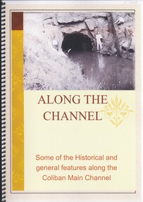
Book - ALONG THE CHANNEL
Along The Channel, some of the historical and general features along the Coliban main channel, 90 pages with black and white and colour photographs & maps.Philip Wilkincivil engineering, water supply, coliban -
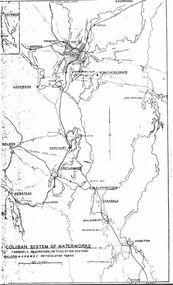 Bendigo Historical Society Inc.
Map - STATE RIVERS AND WATER SUPPLY COMMISSION : COLIBAN SYSTEM OF WATERWORKS MAP
... , Kyneton. Map STATE RIVERS AND WATER SUPPLY COMMISSION : COLIBAN ...State Rivers and Water Supply Commission. Photocopied foolscap-size map. Title: Coliban System of Waterworks. Channels, reservoirs, reticulation systems. Maldon - S.R. & W.S.C. reticulated towns. The map includes the areas from Goornong to south of Kyneton and across to Maldon: Goornong, Marong, Bendigo, Strathfieldsaye, Lockwood, Maldon, Harcourt, Castlemaine, Newstead, Elphinstone, Taradale, Malmsbury, Kyneton.state infrastructure, water supply, coliban system, state rivers and water supply commission. coliban system. -
 Bendigo Historical Society Inc.
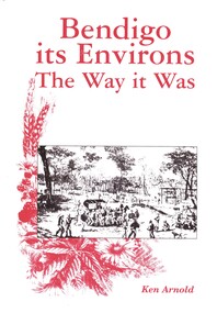
Book - BENDIGO ITS ENVIRONS THE WAY IT WAS, 2003
Bendigo its Environs The way it Was. A brief history of Bendigo & surrounding areas & of the water supply and railway line to Bendigo & surrounds. Contains 432 pages with photographs, illustrations and maps, published by Crown Castleton.Ken Arnoldbendigo, history, bendigo & district, signed by author, limited edition number 175 -
 Bendigo Historical Society Inc.
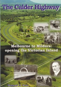
Book - THE CALDER HIGHWAY, 2006
The Calder Highway - Melbourne to Mildura: opening the Victorian Inland. 128 pages with photos and illustrations, maps. Inscribed on fly page ' to Jim Evans with my thanks, Howard Carr'Howard A. Carrstate infrastructure, water supply, calder highway, calder highway, infrastructure -
 Bendigo Historical Society Inc.
Document - NEVILLE KING COLLECTION: MINISTER'S VISIT TO COLIBAN DISTRICT
Manilla folder titled: Minister's visit to Coliban district on Friday 3rd November, 1967. Inside the itinerary, a map of the Coliban system of waterworks, a one page Coliban water investigation committee invitation to lunch November 3rd, 1967 with all the names of the people invited and a three page report titled ''State rivers and water supply commission Coliban system of waterworks''civil engineering, water supply, coliban -
 Bendigo Historical Society Inc.
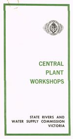
Document - STATE RIVERS AND WATER SUPPLY COMMISSION VICTORIA : CENTRAL PLANT WORKSHOPS
State Rivers and Water Supply Commission of Victoria. Brochure titled 'Central Plant Workshops'. Double-sided, three pages on each. Information about the workshops (CPW for short) and the setting up of the Bendigo site from 1946. There is a map of the layout of the site, and information given under the following headings - Central Plant Workshops, Work of the CPW, Meter Wheels, Pump Station Equipment, Steel Fabrication, Precast Concrete, and the Area and its Equipment. The brochure is dated June, 1968.state infrastructure, water supply, coliban system, state rivers and water supply commission of victoria. coliban system. central plant workshops. -
 Bendigo Historical Society Inc.
Map - SUTTON GRANGE : COUNTY OF BENDIGO, 21-7-22
Map. Sutton Grange, County of Bendigo, County of Talbot, Mandurang, Sedgwick, Ravenswood, Hawkestone, Harcourt, Faraday. Myrtle Creek. Victorian Water Supply - Main Line of Aquaduct from Malmsbury to Sandhurst. By authority A.J. Mullett, Government Printer, Melbourne. Photo-Lithographed at the Department of Lands and Survey, Melbourne by W.J. Butson, 21-7-22. Price 1/-. (number 125 in map cupboard 1)A.J. Mullett, Government Printer, Melbourne.map, bendigo, sutton grange -
Bendigo Historical Society Inc.
Map - SUTTON GRANGE : COUNTY OF BENDIGO, 21-7-22
Map. Sutton Grange, County of Bendigo, County of Talbot, Mandurang, Ravenswood, Harcourt, Faraday, Hawkestone, Lyell, Sedgwick, Myrtle Creek, Victorian Water Supply - Main Line of Aquaduct from Malmsbury to Sandhurst. By authority A.J. Mullett, Government Printer, Melbourne. Photo-Lithographed at the Department of Lands and Survey, Melbourne by W.J. Butson 21-7-22. Price 1/-. (number 124 in map cupboard 1)A.J. Mullett, Government Printer, Melbourne.map, bendigo, sutton grange -
Bendigo Historical Society Inc.
Map - HARCOURT : COUNTY OF BENDIGO, 23-3-10
Map. County of Bendigo, County of Talbot, Sutton Grange, Ravenswood, Walmer, Faraday, Castlemaine, Axe Creek, Barkers Creek, Melbourne to Echuca Railway, Victorian Water Supply in Connection with Barkers Creek Reservoir. Victorian Water Supply Reserve, Mt. Alexander State Forest. Three areas reserved for Sericulture (Silkworms). Photo-Lithographed at the Dept. of Lands and Survey, Melbourne by T.F. McGauran 23-3-10. Price 1/-. (number 101 in map cupboard 1)T.F. McGauranmap, bendigo, harcourt -
Bendigo Historical Society Inc.
Map - HARCOURT : COUNTY OF BENDIGO, December 1951
Map. Harcourt, County of Bendigo, County of Talbot, Town of Harcourt, Walmer, Sutton Grange, Ravenswood, Victorian Water Supply Reservoir, in connection with Barkers Creek Reservoir, Barkers Creek, Calder Highway, Northern Railway, Axe Creek. By authority J.J. Gourley, Government Printer, Melbourne. Drawn and reproduced at the Department of Lands and Survey, Melbourne. December 1951. Price 5/- per sheet. (number 100 in map cupboard 1)J.J. Gourley, Government Printer, Melbourne.map, bendigo, harcourt -
Bendigo Historical Society Inc.
Map - HARCOURT : COUNTY OF BENDIGO, December 1951
Map. Harcourt, County of Bendigo, County of Talbot, Ravenswood. Sutton Grange, Walmer, Castlemaine, Faraday, Calder Highway, Northern Railway, Town of Harcourt, Barkers Creek, Victorian Water Supply Res., in connection with Barkers Creek Reservoir. By authority J.J. Gourley, Government Printer, Melbourne .Drawn and reproduced at the Department of Lands and Survey, Melbourne. December 1951. Price 2/- per sheet. (number 96 in map cupboard 1)J.J. Gourley, Government Printer, Melbourne.map, bendigo, harcourt -
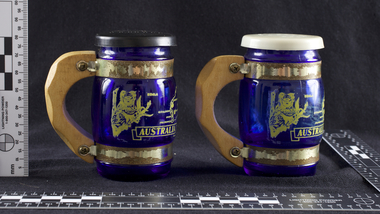 Melbourne Water
Souvenir Salt and Pepper Shakers, 1970s
The Maroondah System was first and foremost developed as a functional component of Melbourne's Water Supply System. In addition to functionality, the Melbourne and Metropolitan Board of Works (MMBW) envisioned the Maroondah Reserve to be enjoyed aesthetically and recreationally by the public. This souvenir illustrates the realisation of the Maroondah System as a local recreational and tourist attraction in the early 20th century. The Maroondah Reserve gardens were landscaped with English-style ornamental stonework, exotic trees, flower beds and rose gardens. All features of the water supply system became widely celebrated as beauty spots that continue to be very popular to this day with tourists and locals alike. This souvenir is a product of that flourishing tourist trade. These water supply sites continue to enhance Melbourne’s charm and liveability and are now recognised as places of cultural and historic significance.These souvenir salt and pepper shakers have been curated by Melbourne Water as they represent an important historical aspect of the organisation by demonstrating the popularity of its water asset sites as recreational places and tourist attractions, and although these sites are functional parts of the water supply system, they were also designed to be enjoyed by the public both aesthetically and recreationally. Additionally, the salt and pepper shakers are aesthetically pleasing as the blue glass and wooden handles demonstrate the design and style of the 1970s. These souvenir salt and pepper shakers feature glass bodies, wooden handles and plastic lids. The salt and pepper shakers are decorated with pictures of koalas, kangaroos and a map of Australia. The text “Maroondah Dam, Vic” has been inscribed on the wooden handles.melbourne metropolitan board of works, mmbw, maroondah, salt and pepper shakers, souvenir, glass, healesville -
 Bendigo Historical Society Inc.
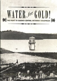
Book - WATER FOR GOLD, 2009
Water for Gold, The fight to quench central Victoria's goldfields. Published by Australian Scholarly Publishing with a grant from Coliban Water to celebrate the 15th anniversary of the first serious attempts by the Bendigo Water Works Company in 1859 to supply water to the goldfields of Central Victoria, 288 pages photographs, illustrations & maps. Signed by the author.Geoffrey Russellvictoria, history, water, bendigo - history, central victorian goldfields, coliban water. -
 Bendigo Historical Society Inc.
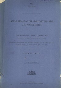
Book - ANNUAL REPORT OF THE SECRETARY FOR MINES AND WATER SUPPLY, c1897
Annual Report Of The Secretary For Mines And Water Supply, Victoria 1896. Publisher: Government Printer, Melbourne. 71 pages. Maps & drawings. Inscriptions: Little 180, see page 59 (cover), A Richardson, 29 Harrison St, Bendigo (1st page).victoria, victorian mining report, mining machinery mine safety mining statistics bendigo mines -
 Yarra Ranges Regional Museum
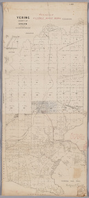
Map, District of Yering, 1 Dec 1885
Canvas backed paper map of District of Yering, Country of Evelyn, showing proposed waterworks for township of Lilydale. Signed by Hodgson & Smith, water supply engineers. Proposed waterworks for the township of Lilydale. Signed by Hodgson & Smith, water supply engineers. Proposed water main shown with of reservoir etc. Canvas backed paper map of District of Yering, Country of Evelyn, showing proposed waterworks for township of Lilydale. Signed by Hodgson & Smith, water supply engineers. Proposed waterworks for the township of Lilydale. Signed by Hodgson & Smith, water supply engineers. Proposed water main shown with of reservoir etc. evelyn, lilydale, waterworks and irrigation -
Tatura Irrigation & Wartime Camps Museum
file, State Rivers & Water Supply Commission
This collection was owned by Keith Daniel, an accountant with SR & WSC. Resident in Tatura 6-7 years until 1965File containing - Victorian Government Gazette March 6, 1968. - - Map, Goulburn Irrigation System - Murchison A, SR & WSC Journal "Aqua" April 1966 , Lake Eppalock Boating Guide, "Aqua Summer 1991, Brochure & newspaper adv. re: Waranga Lakeside estate.1974 -
Tatura Irrigation & Wartime Camps Museum
Photograph, Goulburn Irrigation System, 1970s
Taken by photographer for State Rivers and Water Supply Commission.Medium sized black and white photograph. Map showing the Goulburn Irrigation System in Northern Victoria including Eildon Reservoir, Waranga Reservoir, Eppalock Reservoir, Eppalock, Cairn Curran, Laancoorie, Tullaroop Reservoirs, the Stuart Murray, Cattanach Canal, East Goulburn Main and Waranga Western Channels.goulburn weir, victorian state rivers and supply commission -
Tatura Irrigation & Wartime Camps Museum
Map, State Rivers and Water Supply Commission, Goulburn Irrigation System, C 1940
... supply commission map Irrigation Rivers Victoria. A map showing ...A map showing the extent of Goulburn irrigation C. 1940. Also indicated by shading are: natural water resources, proposed extensions, existing stock and domestic supply areas, reservoirs, main channels, principal distribution channels, and railways.Irrigation Rivers Victoria.irrigation, victoria state rivers and water supply commission, map -
 Tatura Irrigation & Wartime Camps Museum
Folio, Camp 3
Material collected and donated Material relating to Camp 3 and the Internees from Palestine. Sketch map of Camp 3 Memorium to Dieter Ruff, former Head of the Temple Society. Photo of steam passenger train at Rushworth Station. Various group photos. Copy of sketch of hut by Winkler. "in the Internment Camp Tatura" by K.M. Pfander Copy of talk given to her former pupils by Gudrun Gollong, in 1978. Poem written in Camp by Annie Lorenz. Poem by unknown writer "Life's Daily Routine" Interview with Babette Kirsch. Copy of children's learning book in German. Photos of toys and craft made for Kaltenbach family. Copy of Kaltenbach barracks by Cesare Vagarini. Story of Wilhelm Kuebler. Photos of wooden boxes made for Sgt. Cubbin. Copy of letter in German confirming the death in Camp of the two Stuerzenhofecker children. Copy of records Theo Stoll. School records Waltraud Doster Copy of Marriage Certificate Vollmer/Zollinger, August 1946. Recollections of Private Ashworth, guard at Camp 3. Photo taken 2001 by John Wepner of pump which supplied water to Camps 3 & 4 from No. 9 channel. Sketch of canoe made in camp from a sheep drinking trough by the Haering family. "From the Holy Land to the Home of the Kangaroo", by Hedwig Schnerring, translated by Peter Hornung, donor- Guenther Schnerring. "The Long Arm of the Third Reich" by Christine Winter. Photocopied extract of Walter Odorich Stenner's diary account of the transportation from Haifa to Australia. Research - Tatura WW2 Internment Camp 3, Annie Leschen Copy of map showing pump sites for water for Camps 3 and 4 Copy (laser) of a painting donated by Frieder Vollmer, artist "D 1943"? Adalbert Stern, Sir Nicholas - Son of Dunera boy "Adalbert Stern Copies of photos (4) of 2 cakes of Lux soap with pictures of "Roll Call, Tatura 1941" on one side and "Lux Toilet Soap" on the other Newspaper Article from "The Age" 14/04/1999 re Vagarini Exhibition Camp 3TaturaBlack 3 ring folder with printed matter and photos in plastic sleeves.documents, reports -
Tatura Irrigation & Wartime Camps Museum
Map, Irrigation Trust distribution channels
Map retrieved from State Rivers & Water Supply Commission Offices by Gilian Payne. Map of Rodney Irrigation Trust distribution channels, 1887, prepared by Walter Scott Murray. Copied in seven sections. -
Clunes Museum
Document - DOCUMENTS/MAP, 1874-5
... , 1875 DONATED TO MUSEUM BY JEFF MACK document letters map water ...COLLECTION OF LETTERS - 1 X JANUARY 5,1874 1 X MAY 23, 1874 1 X JANUARY 8, 1874 1 X SEPTEMBER 4, 1874 1 X JANUARY 10, 1874 1 X APRIL 5, 1875 1 X JANUARY 15, 1874 1 X MAY 10, 1875 1 X JANUARY 22, 1874 1 X MAY 13, 1875 (3 PAGES) 1 X JUNE 7, 1875 1 X JANUARY 28, 1874 1 X JUNE 29, 1875 1 X JANUARY 29, 1874 1 X DECEMBER 23, 1875 DONATED TO MUSEUM BY JEFF MACKCOLLECTION OF LETTERS(3) FROM MR. JESSUP (SOLICITOR) OF CLUNES WATER SUPPLY FROM 1870. PRIVATE LETTER FROM JEFF MACKAY. MAP - CLUNES RETICULATION CIRCA 1874. DETAILS OF PIPES LAID AND PROPOSED PIPE LINES, FIRE PLUGS, VALVES.CORRESPONDENCE FROM SOLICITOR (MR. JESSUP) 1874-5document, letters, map, water supply, mr. jessup -
Clunes Museum
Map
... MAP OF CLUNES WATER SUPPLY, TOWNSHIP OF CLUNES, SHOWING... TOWNSHIP OF CLUNES MAP OF CLUNES WATER SUPPLY, TOWNSHIP OF CLUNES ...MAP DATED JULY 21ST,1873MAP OF CLUNES WATER SUPPLY, TOWNSHIP OF CLUNES, SHOWING SYSTEM OF DISTRIBUTION.TOWNSHIP OF CLUNESlocal history, document, maps, clunes water -
Stawell Historical Society Inc
Map, T.F. McGauran, William Couty of Borong 1891, 1891
Stawell Water Supply Reserve. Grampians State Forest. Dairy Creek, Fyans Creek, Barney's Creek, Bovine Creek, Glasstree Creek, Stoney Creek. Stawell Water Supply Aquaduct Fkuming Tunnel.A2 Parish Map of Willam Inculdin Stawell Water Supply Reserve and Creeks. Marked in redPhoto Lithographed at the Department of Lands and Survey Melbourne. By T.F. McGauran 20.07.91 water supply survey -
Whitehorse Historical Society Inc.
Map, Melbourne and Metropolitan Board of Works, 1925
1925 plan of the Yan Yean, Maroondah and O'Shannassy water supply systems.1925 plan of the Yan Yean, Maroondah and O'Shannassy water supply systems.1925 plan of the Yan Yean, Maroondah and O'Shannassy water supply systems.water supply, melbourne and metropolitan board of works -
Whitehorse Historical Society Inc.
Pamphlet, Melbourne's water; a community problem, 1968
Collection of papers relating to Melbourne's future water needs by Leigh Blackburn with map extractsCollection of papers relating to Melbourne's future water needs by Leigh Blackburn with map extracts defining the area the author considers the most suitable for the development of future water resources and the dangers of the Lower Yarra Dam proposals.Collection of papers relating to Melbourne's future water needs by Leigh Blackburn with map extracts water supply, melbourne and metropolitan board of works, state rivers and water supply commission, lower yarra dam -
 Otway Districts Historical Society
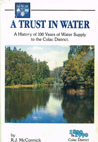
Book, A trust in water, 1990
The harnessing of the bountiful water resources of the Otways as a critical element in the urban and agricultural development of the Colac region.A trust in water. A history of 100 years of water supply to the Colac district. R.J. McCormick. 1st ed. np; R.J. McCormick; 1990. xxii, 324 p.; illus, map. Hard cover. ISBN 0 7241968 2 X a trust in water; r.j. mccormick; colac; water resources; sewerage; west gellibrand dam; otways; -
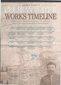 Bendigo Historical Society Inc.
Document - JOSEPH BRADY COLLECTION: COLIBAN SYSTEM OF WATER WORKS PAMPHLET
Three copies of Joseph Brady's Coliban System of Water Works - A Historical Guide to Celebrate 125 Years of Water Delivery to Bendigo & Castlemaine by Coliban Water. Mentioned in the brochure is Gold & Water, The Original Coliban System of Water Works, The Coliban System Today, The Coliban Engineer - Joseph Martin Brady (1828 - 1908), Coliban System of Water Works Key Facts & Figures, The Aqua Project, Historical Guide, Coliban System of Water Works Map, photo of Joseph Brady, Photo of gold diggers and channel works.Coliban Watercivil engineering, water supply, coliban, joseph brady's coliban system of water works, coliban water, the original coliban system of water works, the coliban system today, joseph martin brady 1828 - 1908, gavan prendergast, coliban system of water works key facts & figures, the aqua project, historical guide to 125 years of water delivery to bendigo & castlemaine, map of system -
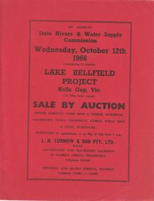 Bendigo Historical Society Inc.
Document - IAN DYETT COLLECTION: AUCTION CATALOGUE - LAKE BELLFIELD PROJECT
Two copies of red covered auction catalogue for sale on account of State Rivers & Water Supply Commission held on 12/10/1966 Lake Bellfield Project, Hall Gap, Vic. Lots include motor vehicles, corr. Iron & timber buildings, machinery, tools, equipment, stores, scrap iron & steel and furniture. J. H. Curnow & son Pty. Ltd. Were the auctioneers. Catalogue has a map from Melbourne & Geelong to site near Hall's Gap and an Auction Layout sketch.business, auctioneers, j h curnow & son pty ltd, ian dyett collection - auction catalogue - lake bellfield project, state rivers & water supply commission, j h curnow & son pty ltd, f c dyett, l c osborne, c hill