Showing 11184 items matching "water-supply"
-
 Stawell Historical Society Inc
Archive, Stawell Water Supply. Foreman’s Reports 1949 – 1959, 14/6/1949 - 20/5/1959
Heavy Card Cover - Leather Trim. Fawn in ColourForeman's Reports. Stawell Water Supplystawell -
 Stawell Historical Society Inc
Photograph, Water Flume fo the Stawell Water Supply
B/W Photograph of Water Flume with trees either side. Mountain Range in Background. This was part of Stawell Water Supply. water supply, water -
 Melton City Libraries
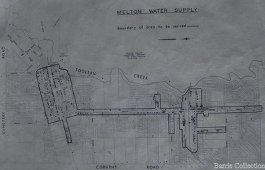
Map, Melton Water Supply, Unknown
The development that had arguably the greatest impact in encouraging population growth in the shire during this period, was the establishment of a reliable water supply for the district. This had been a major concern of the local community for over 100 years, since the Melton township was first founded. Despite various schemes over the years to create a reliable water supply, the district was still dependent on bores, wells and tanks when the Melton Waterworks Trust was established in 1961 to address Melton’s water woes. With the opening of the Djerriwarrh Dam in December 1963, the shire’s residents finally had access to a reticulated water supply.Map shows the boundary of the area where the water will be serviced in the towncouncil -
 Stawell Historical Society Inc
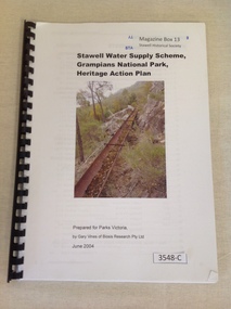
Book, Gary Vines, Stawell Water Supply Scheme, Grampians National Park, Heritage Action Plan, 2004
White paper with black print and colour photo of a water race. this book has a black plastic bindingStawell Water Supply Scheme, Grampians National Park, Heritage Action Plan. Prepared for Parks Victoria, by Gary Vines of Biosis Research Pty Ltdstawell -
 Wodonga & District Historical Society Inc
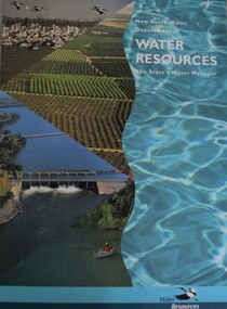
Booklet - New South Wales Department of Water Resources: The State's Water Manager, Department of Water Resources New South Wales, 1994
... water-supply ...This publication includes sheets related to water facts and information about water issues in New South Wales, Australianon-fictionThis publication includes sheets related to water facts and information about water issues in New South Wales, Australiawater-supply, new south wales. department of water resources, water resources development -
Tatura Irrigation & Wartime Camps Museum
Sign - Notice Board, Rodney Irrigation and Water Supply Trust
Made to commemorate the first meeting of the Rodney Irriagation and Water Supply Trust.Commemoration Board of dark brown wood with gold writingRodney Irrigation and Water Supply Trust First meeting held on 28th May 1889 Commissioners M Cussen Chairman W Bray, M Minter, J Cooke, J Morrisey, T Hogan, J Stewart, M Kavanagh, J Teese, S Lancaster, C W Wilson, J McKenzie Engineer W S Murray Secretary J A Careym cussen, w bray, m minter, j cooke, j morrissey, m kavanagh, j stewart, j teese, s lancaster, c w wilson, j mckenzie, w s murray, j a carey, rodney irrigation and water supply trust -
 Melton City Libraries
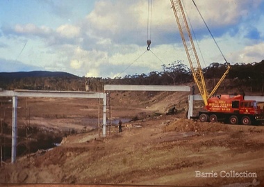
Photograph, Construction of Dam Wall- Melton Water Supply, 1963
Photographs of the construction of the dam wall for Melton's water supplylocal significant events, council, local architecture, local identities -
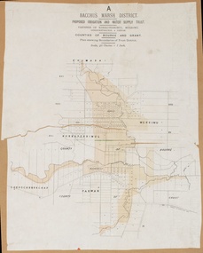
 Bacchus Marsh & District Historical Society
Map, Lerderderg District Proposed Irrigation and Water Supply Trust (A). Plan showing boundaries of Trust District
The 1886 Irrigation Act in Victoria introduced the first legislation in Australia designed to enable the creation of a detailed scheme for agricultural irrigation. Part of the legislation saw the use of government funds for local irrigation projects. These local projects were managed by local irrigation trusts. The Lerderderg Irrigation and Water Supply Trust] was formed in 1890. This map depicts the proposed area of the Trust.Printed paper map of the proposed Lerderderg District Irrigation and Water Supply. Plan showing boundaries of Trust District. The Lerderderg District lies within the Parishes of Korkuperrumul and Merrimu in the County of Bourke. At the top of the map above its title is the letter 'A; in capital lettering. Scale: 40 Chains = 1 inch.irrigation, water supply, lerderderg irrigation and water supply trust -
University of Melbourne, Burnley Campus Archives
Plan, Water Supply, c. 1960
A. Plan of existing and proposed new buildings, temporary structures or due for demolition. Water Supply Plan sketched over. B. Sketch plan on tracing paper, further details of water supply.water suplly -
 Bacchus Marsh & District Historical Society
Map, Bacchus Marsh District (A). Proposed Irrigation and Water Supply Trust. Plan shewing boundaries of Trust District
The 1886 Irrigation Act in Victoria introduced the first legislation in Australia designed to enable the creation of a detailed scheme for agricultural irrigation. Part of the legislation saw the use of government funds for local irrigation projects. These local projects were managed by local irrigation trusts. The Bacchus Marsh Irrigation and Water Supply Trust was formed in 1889. This map depicts the proposed area of the Trust.Printed paper map of the proposed Bacchus Marsh Irrigation and Water Supply district. Circa 1889. Plan showing boundaries of Trust District. The District lies within the Parishes of Korkuperrimul, Merrimu, Parwan and Gorrockburkchap in the Counties of Bourke and Grant. At the top of the map above its title is the letter 'A; in capital lettering. Scale: 40 Chains = 1 inch.irrigation, water supply, bacchus marsh irrigation and water supply trust -
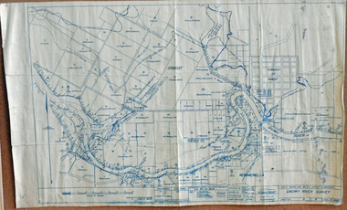 Orbost & District Historical Society
survey, 1941
this item is a useful reference tool.A survey map produced by the State Rivers and Water Supply Commission. It is on white paper with blue ink. It is a hand-drawn survey of the Snowy River in 1939-40.survey map snowy-river -
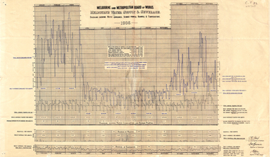 Whitehorse Historical Society Inc.
Document, Melbourne water supply, 1937
Melbourne and Metropolitan Board of Works. Melbourne water supply and sewerage. Diagrams showing water consumed, sewage pumped, rainfall and temperature, 1936.melbourne and metropolitan board of works, sewerage and sanitation, rainfall, temperature -
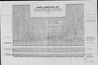 Whitehorse Historical Society Inc.
Document, Melbourne water supply, 1932
Melbourne and Metropolitan Board of Works, Melbourne water supply and sewerage diagrams showing water consumed, sewage pumped, rainfall and temperature, 1931.melbourne and metropolitan board of works, sewerage and sanitation, rainfall, temperature -
 Bacchus Marsh & District Historical Society
Map, Lerderderg District Proposed Irrigation and Water Supply Trust (C). Plan showing overlap in boundaries of the Trust District
The 1886 Irrigation Act in Victoria introduced the first legislation in Australia designed to enable the creation of a detailed scheme for agricultural irrigation. Part of the legislation saw the use of government funds for local irrigation projects. These local projects were managed by local irrigation trusts. The Lerderderg Irrigation and Water Supply Trust was formed in 1890. Printed paper map of the proposed Lerderderg District Irrigation and Water Supply. Plan showing overlap in boundaries of Trust District referred to in Mr Burke's report. The Lerderderg District lies within the Parishes of Korkuperrumul and Merrimu in the County of Bourke. At the top of the map above its title is the letter 'C; in capital lettering. A note on this map states: 'Portion of Bacchus MarshUrban District included in area of proposed Trust District shown by hatched shaded lines thus /////////////irrigation, water supply, lerderderg irrigation and water supply trust -
Whitehorse Historical Society Inc.
Booklet - Pamphlet, A Historical survey of Melbourne's water supply, 1942
Based on an address by J.C. Jessop, 8 May 1942. With plan of Melbourne's water supply system.Based on an address by J.C. Jessop, 8 May 1942. With plan of Melbourne's water supply system.Based on an address by J.C. Jessop, 8 May 1942. With plan of Melbourne's water supply system.water supply, melbourne and metropolitan board of works., blackburn, james, hodgkinson, clement, oldham, t -
 Bacchus Marsh & District Historical Society
Map, Lerderderg District Proposed Irrigation and Water Supply Trust (B) Plan Showing Proposed Works
The 1886 Irrigation Act in Victoria introduced the first legislation in Australia designed to enable the creation of a detailed scheme for agricultural irrigation. Part of the legislation saw the use of government funds for local irrigation projects. These local projects were managed by local irrigation trusts. The Lerderderg Irrigation and Water Supply Trust was formed in 1890. This map depicts the proposed area of the Trust and proposed works such as channels and weirs.Printed paper map of the proposed Lerderderg District Irrigation and Water Supply area showing proposed works. The map scale is 40 chains + 1 inch. The Lerderderg District lies within the Parishes of Korkuperrumul and Merrimu in the County of Bourke. At the top of the map above its title is the letter 'B; in capital lettering. A series of proposed channels are indicated on the map in red lines. A proposed weir site and alternative weir site are also indicated on the map. irrigation, water supply, lerderderg irrigation and water supply trust -
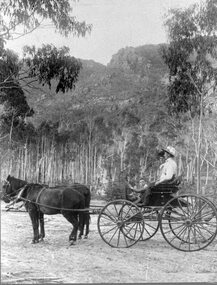 Stawell Historical Society Inc
Photograph, Stawell Water Supply Water Ranger’s Wife -- Mrs Cumming nee Unknown in a Jig in the Grampians
Stawell Water Supply Water Ranger’s Wife. Mrs. Cumming in jig Grampiansstawell -
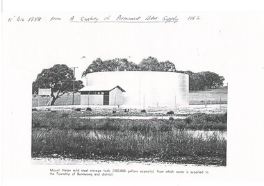 Buninyong & District Historical Society
Photograph - Copy of a publication depicting Mount Helen water tank 1958, Mount Helen water tank 1958
This image depicts the opening of the permanent water supply for the Buninyong Township and District in 1958 for Buninyong Water TrustThis image illustrates the turning on the valve for the first permanent water supply to Buninyong in 1958A black and white photocopy of a photo showing the 500,000 gallon capacity water tank at Mount HelenMount Helen mild steel storage tank, (500,00 gallons capacity) from which water is supplied to the Township of Mount Buninyong and district.buninyong water trust, buninyong water supply, mount helen water storage tank -
Tatura Irrigation & Wartime Camps Museum
Map, State Rivers and Water Supply Commission, Goulburn Irrigation System, C 1940
A map showing the extent of Goulburn irrigation C. 1940. Also indicated by shading are: natural water resources, proposed extensions, existing stock and domestic supply areas, reservoirs, main channels, principal distribution channels, and railways.Irrigation Rivers Victoria.irrigation, victoria state rivers and water supply commission, map -
Tatura Irrigation & Wartime Camps Museum
Document, Royal Commission on Water Supply - Minutes of Evidence, 1896
34 Pages of evidence taken at the 1896 Royal Commission on Water Supply. Some of the hearing was held at Tatura. A4 Photocopy -
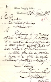 Federation University Historical Collection
Document - correspondence, Ballarat Water Supply Office to Ballarat School of Mines, 25/08/1898
.1) A handwritten memorandum on 'Ballarat Water Supply Office' Memorandum letterhead. The Memo reads: Memorandum from the Water Supply Office, Grenville Street, near the Gas Works. Ballarat 13 April 1898 To the Registrar Schoolof Mines Ballarat Sir, I write your attention to the letter from this office dated 2nd December 1897 requesting that a suitable meter be affixed to the Water Supplu pipe at the School. I am directed to ask if the request has been complied with. Yours obediently J. [?]. Cathcart .2) A handwritten letter from J. Cathcart on 'Water Supply Office' letter head. The letter reads: Water Supply Office Ballarat 25th April 1898 The Director The School of Mines Ballarat Sir, Referring to my memo of the 13th instant relative to a meter being installed to the water supply pipe at the School of Mines - Will yo be so good as to favor me with a reply without further delay. I am Sir Your Obedient Serv't J. [M?] Cathcart Secretary.2) Written in a red circle '238'.ballarat school of mines, ballarat water supply, water, cathcart -
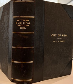 Kew Historical Society Inc
Journal, Arnall & Jackson: Printers & Stationers, Victorian Municipal Directory and Gazetteer : Also Commonwealth Guide and the Water Supply Record for 1928
The Victorian Municipal Directory provided annual details, and later bi-annual details, of all councils. Published by Arnall & Jackson (Printers and Stationers), copies were published in 'cloth' for sixteen shillings and 'half roan' for eighteen shillings. This copy was owned by Cr C.S.Parry. Elected to the Kew City Council as a representative of North Ward, Cr Parry was elevated to the position of Mayor in 1931. It, together with five other editions, was presented to the Kew Historical Society in 1987 by his grandson.Bound copy of the Victorian Municipal Directory and Gazetteer: Also Commonwealth Guide and the Water Supply Record for 1928. The volume contains 846 pages and includes sections on: - Comparative table – Municipal Returns for Twenty-one Years. - Index to Townships, Parishes and Railway Stations. - Changes and appointments. - Commonwealth of Australia (Constitution, Parliament, Departments and Officers). - State of Victoria (Parliament, Departments and Officers / Boards, Institutions, Trusts and Loans). - Municipalities in Victoria (Cities and Towns, Boroughs, Shires). - Water Supply (State Rivers and Water Supply Commission).non-fictionThe Victorian Municipal Directory provided annual details, and later bi-annual details, of all councils. Published by Arnall & Jackson (Printers and Stationers), copies were published in 'cloth' for sixteen shillings and 'half roan' for eighteen shillings. This copy was owned by Cr C.S.Parry. Elected to the Kew City Council as a representative of North Ward, Cr Parry was elevated to the position of Mayor in 1931. It, together with five other editions, was presented to the Kew Historical Society in 1987 by his grandson. victoria -- registers -- periodicals., victoria -- directories., water-supply -- victoria -- directories., municipal government -- victoria -- periodicals., cities and towns -- victoria -- directories. -
 Ringwood and District Historical Society
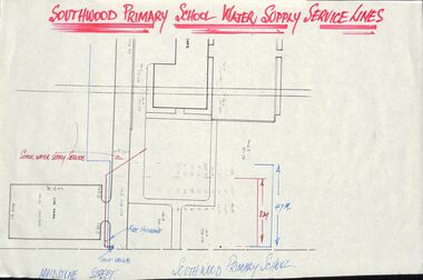
Plan - Plans, Southwood Primary School, Ringwood, Collection of plans for water supply, sewerage and drainage
folder of paper plansSouthwood P.S. Water Supply, Sewerage & Drainage Plans. Permanent File. To be archived at P.R.O. when no longer required. -
Federation University Historical Collection
Letter, Letter from Department of Mines and Water Supply to Fred J. Martell
School of Mines Ballarat is a predecessor of Federation UniversityHandwritten Letter on Letterhead from Department of Mines and Water Supply to Fred J. Martell Director of School of Mines Ballarat regarding expenditureletter, department of mines and water supply, ballarat school of mines, fred j. martell, p. cohen, expenditure -
Whitehorse Historical Society Inc.
Document, Water supply for market gardens
water supply for market gardens- a standpipe at the corner of Warrigal and Toorak Roads, c1916Photo with caption - water supply for market gardens- a standpipe at the corner of Warrigal and Toorak Roads, c1916; photocopy from 'A History of Camberwell' by Geoffrey Blainey. water supply for market gardens- a standpipe at the corner of Warrigal and Toorak Roads, c1916water supply, stand-pipe -
 Phillip Island and District Historical Society Inc.
Letter, Letter to the Minister for Minister Supply
This illustrates the early attempts to have a water supply connected to Cowes. Shows figures on local properties and what is required for water supply. Also the history of local guesthouses.HistoricalFoolscap carbon copy of letter to the Minister of Water Supply. Seven pages of typewritten letter. water supply, shire of phillip island island, agriculture, population, cowes, isle of wight hotel, bonnie doon guest house, d.h.robb, r.a. grayden, h.v. johnston, j. thornborrow, charmandene guesthouse, mrs a. anderson -
Tatura Irrigation & Wartime Camps Museum
CD, 1961 State Rivers and Water Supply Commission Water Loss Report to Victorian Government Public Works Committee
Donor F.L. Burns was a design engineer with State Rivers and Water Supply Commission and wrote, as part of a report, "methods of reducing seepage losses".Silver disc. Black text. Inside a black and clear plastic rectangular cover.irrigation, victoria state rivers and water supply commission -
 Greensborough Historical Society
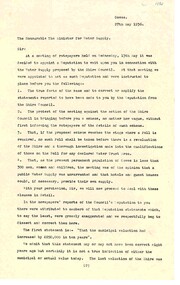
Booklet, Parks Victoria, Wallaby Creek: designated water supply catchment area. Kinglake National Park: Draft management plan 1998, 1998_02
Wallaby Creek is part of Kinglake National Park, and is a restricted access catchment area to protect quality of water supplied to Melbourne's water supply system. 26 p. black print on white paper, green cover, three folded mapskingllake national park, water supply, wallaby creek, parks victoria -
 Kilmore Historical Society
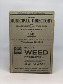
VICTORIAN MUNICIPAL DIRECTORY 1962, Victorian Municipal Directory also Commonwealth and State Guide and Water Supply Record for 1962, 1962
Advertised cloth cover With printed detailing on cover and spine 'Victorian Municipal Directory also Commonwealth and State Guide and Water Supply Record for 1962' xxv; 1147 pages ; 18cm; municipal directory, state, commonwealth guide, water supply record, kilmore mechanics institute library. -
 Federation University Historical Collection
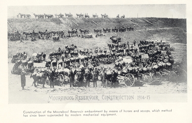
Book, A Century of Permanent Water Supply, 1962
Blue covered book.non-fictionwater, water management, moorabool reservoir, ballarat sewerage authority, sebastopol sewerage treatment works, ballarat north sewage treatment works, sebastopol sewage treatment works