Showing 74 items
matching weather conditions
-
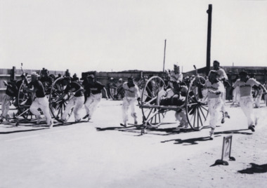 The Beechworth Burke Museum
Photograph, c1950s
... every year since 1873. The event goes on regardless of weather... every year since 1873. The event goes on regardless of weather ...Photograph of 2 teams with hoses and reels in a race as part of a CFA competition. Fire brigade competitions have been running for almost 150 years with the first State Championship held in Melbourne in 1874. State Championships have continued every year since 1873. The event goes on regardless of weather conditions or natural disasters. The only cancellations being due to WWI and WWII. In the 1950s, the Rural State Championships were developed to reflect the unique skills of rural brigades. The competitions started out as 'Demonstrations' with the introduction of hose reels into the fire service in the mid 1800s. This was to assist in getting hose and other necessary equipment to the scene of a fire faster. Brigades soon find that competing with other brigades improved their training and efficiency. The State Championship became the peak of the season's competitions conducted by districts and associations across the state. Black and white rectangular photo reproduction printed on matte photographic paperemergency services, beechworth, fire brigade, firemen, photograph, competition, black and white, fire -
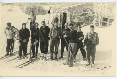
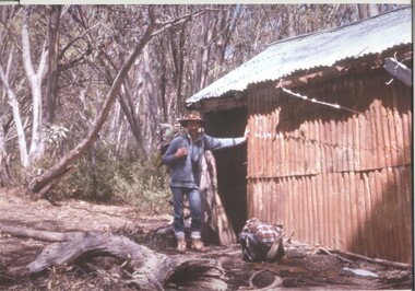 Kiewa Valley Historical Society
Photograph - Coloured Photographs x 5 - Bogong High Plains, January 1969 and c1970
... and Mick Hull survived. The weather conditions were extreme... survived. The weather conditions were extreme at the time ...Bivouac Hut was built in 1935 on the Northern end of Mt. Bogong, on the Staircase Spur, about halfway to the summit. It was funded by Cleve Cole and he arranged for Walter Maddison to build it. Cleve Cole dedicated his life to the mountains and wanted to make them safer to visit - more huts and improved maps, pole lines and tracks. He perished in the winter of 1936 after attempting to make the first winter crossing from Mt. Hotham to Mt. Bogong on skis. The two others with him, Howard Michell and Mick Hull survived. The weather conditions were extreme at the time and having made the summit of Mt. Bogong they then became disorientated in the blizzard and came down the southern end of Bogong instead of the northern end . Howard Michell made it out to Glen Valley, a small mining town, to get help. Mick and Cleve were carried out on rough bush stretchers and Cleve died a few hours later. The Summit Hut was funded by Howard Michell and built in the 1940's. It was deliberately burnt down in the early 1980's. Bivouac hut was rebuilt in the 1980's.These photographs are of historical significance. Both huts were funded by experienced bushwalkers to provide shelter from the weather and so make walking and skiing in the area safer. They are both now gone with Bivouac being replaced with a more modern structure but there is nothing left of the Summit Hut. 5 coloured photographs, A4 in size, 4 near the summit of Mt. Bogong (Three of the Summit Hut) and one of Bivouac Hut on the Staircase Spur leading up to the summit.1. Hand written in ink on back of Photo - "Mt. Bogong Sep. 1976' - all underlined. Below this "Staircase Spur Hut The bloke in the hat me (David Jones)". 2. Handwritten in ink on back of photo - "Mt. Bogong winter 1970" (underlined). Underneathe "Same old Hut". 3. Handwritten in ink "Mt. Bogong Jan. 1969" (Underlined) Underneath "Tawonga Saddle looking towards the Summit". 4.Handwritten in ink back of photo "Mt. Bogong Jan. 1969" (underlined) Old hut near Summit, since removed, at the top of Staircase Spur. View looking out over Kiewa Valley." 5.Hand written on back of photo "Mt. Bogong Jan. 1969" (Underlined). Underneath - " Same old Hut (Staircase Spur) early morning".mt. bogong, summit hut, bivouac hut -
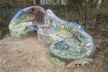 Nillumbik Shire Council
Public Art: Lasting Memories Mosaic GROUP, Lasting Memories Mosaic Seat (Location: St.Andrews Hall, 1 Proctor Street, St. Andrews), 2012
... disaster. The fires occurred during extreme bushfire-weather... extreme bushfire-weather conditions and resulted in Australia's ...The 'Black Saturday' bushfires were a series of bushfires that ignited across the Australian state of Victoria on and around Saturday, 7 February 2009. It was Australia's worst ever natural disaster. The fires occurred during extreme bushfire-weather conditions and resulted in Australia's highest ever loss of life from a bushfire: 173 people died and 414 were injured as a result of the fires. For most women being part of the Lasting Memories Mosaic Group was a way of reconnecting to the area, friends and neighbours. As the months went by, the idea of creating a gift to the community together was born. The women wanted to artistically express their memories of what they had experienced. Creating a mosaic seat in the heart of St Andrews allowed the group to be 'in control' of building something from the ground up - a symbol of hope, recovery and renewal. All of their experiences and memories have been included into the seat design, which makes it so special. This mosaic seat is proudly positioned outside the St Andrews Hall, which is also the site for the St Andrews market held every Saturday throughout the year.The Lasting Memories Mosaic group began this piece just after the Black Saturday fires in 2009. After the horrific fires ravaged through St Andrews and the surrounding areas, a group of bushfire affected ladies bravely came back to St Andrews to begin their healing in an artistic way. Each woman created something beautiful and meaningful, using remnants of crockery, glass, tiles and bricks salvaged from their own properties. This artworks identifies who they are and tells their personal 'life journey' and family heritage and memories of what they had experienced before, during and beyond Black Saturday. It is also an expression of their love for the St. Andrews area and the nature and people within it. A large concrete seat in the style of an organic chaise lounge covered in mosaic (broken tiles, glass, crockery and ceramics of all shapes and colour). The pieces have been placed to form pictures, words and patterns that tell and recount stories and memories of reflection, hope and love of a group of people who experienced the Black Saturday bushfires. (Click on links to view details of the seat) black saturday, mosaic, art, lasting memories, st andrews, tiles, glass, fire, concrete, cement, chris reade, ekphrasis2017 -
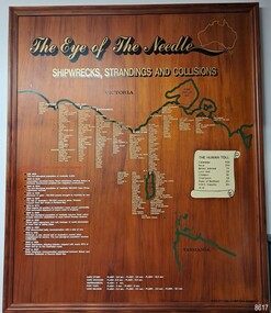 Flagstaff Hill Maritime Museum and Village
Artwork, other - Shipwreck Board, The Eye of the Needle: Shipwrecks, Stranding's and Collisions, ca 2002
... weather conditions. "The Shipwreck Board shows shipwrecks... weather conditions. "The Shipwreck Board shows shipwrecks ...The Shipwreck Board is a feature of Flagstaff Hill Maritime Museum and Village/ its subject is explained briefly in the Museum's handbook, The Flagstaff Hill Navigator, published in 2008: - "Known as the ‘Eye of the Needle’ the treacherous entrance to Bass Strait is littered with the wreckage of large international vessels and smaller sail and steam craft used in coastal trade. The vessels bringing emigrants and cargo to Australia found the western entrance to Bass Strait the most dangerous part of their voyage. They had to thread their way between the southern point of Victoria (Cape Otway) and the northern point of King Island, a stretch of water less than 90 km wide. Many smaller coastal vessels were lost at Portland, Port Fairy, Warrnambool and Apollo Bay which are not safe harbours in certain weather conditions. "The Shipwreck Board shows shipwrecks, strandings and collisions which occurred in this area up to the year 1940. Wrecks are identified by a yellow light and collisions/strandings by a green light. These lights also identify the decade the wreck occurred by lighting up when the relevant decade button is pushed. Interesting happenings of the decades are listed next to the buttons." The Shipwreck Board's demonstration of The Eye of the Needle is an interactive visual display that helps teach the perils and dangers faced by early settlers in Victoria. It tells of the vast number of lives lost. It lists the names of many infamous shipwrecks and significant events.The large stained and lacquered timber board is mounted in a timber, frame. It is painted with a small sketch of Australia, and an enlarged outline of the southern coast of Victoria, King Island and the North West coast of Tasmania. The interactive display highlights the shipwrecks, standings and collisions suffered by many vessels as they navigated the 'Eye of the Needle', a narrow stretch of Bass Strait. The locations of the Lighthouses are pinpointed. Lists of groups of ships are below the coastlines. A painted scroll shows eight major shipwrecks with the number of lives lost for each one. A table shows historical facts associated with the decades from pre-1830 to 1940. A system of coloured lights compares the decades with the vessels that suffered damage. The board was created by artist and signwriter, Alex O'Flynn Computer Signs.flagstaff hill, maritime museum, maritime village, shipwreck coast, eye of the needle, shipwreck locations, bass strait, basses strait, king island, north west tasmania, south coast of victoria, cape otway, victorian lighthouse, king island lighthouse, strandings, coastal tracers, emigrant ships, sea trade, 1930s-1940s, shipwreck board, the eye of the needle, collosions, alex o'flynn, alex o’flynn computer signs, shipwrecks of western victoria -
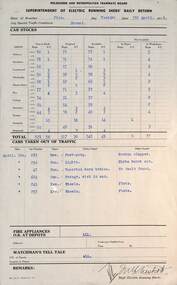
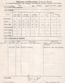
 Melbourne Tram Museum
Administrative record, Melbourne & Metropolitan Tramways Board (MMTB), "Supt electric running sheds daily return", 1939
... of 1938. Give details of the weather, traffic conditions, depot... details of the weather, traffic conditions, depot tram cars ...Administrative record - "Superintendent electric running sheds' daily return" for MMTB dated 28/2/1939 - form 3/312 of 1938. Give details of the weather, traffic conditions, depot tram cars - bogie and single truckers and the cars for the All Night services and their availability. Lists 5 cars taken out of service - defective or accidents, provides detail of status of fire services at depots, and watchmen's tell tales. Would have been compiled from individual depot reports. See item 7516, 7517 and 7518 for similar reports.Yields information the mmtb tram allocation and events at electric running sheds - 1939Completed preprinted foolscap form with type information.tramways, trams, mmtb, depots, daily reports -
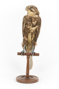 The Beechworth Burke Museum
Animal specimen - Brown Falcon, Trustees of the Australian Museum, 1860-1880
... in weather conditions. This specimen is part of a collection... in weather conditions. This specimen is part of a collection ...The Brown Falcon is a small to medium bird of prey which can be found all throughout Australia. These birds are raptors and typically feed on mammals, birds, snakes, insects and rabbits. The Brown Falcon are located in all but the densest forests. They typically prefer to reside in locations of open grassland and agricultural areas which have scattered trees or telephone poles which the bird can perch on. When frequenting towns located in the Australian Outback, these birds are reportedly quite tame and can be approached by humans. They may stay in the same location throughout the year or chose to move around locally in response to any changes in weather conditions. This specimen is part of a collection of almost 200 animal specimens that were originally acquired as skins from various institutions across Australia, including the Australian Museum in Sydney and the National Museum of Victoria (known as Museums Victoria since 1983), as well as individuals such as amateur anthropologist Reynell Eveleigh Johns between 1860-1880. These skins were then mounted by members of the Burke Museum Committee and put-on display in the formal space of the Museum’s original exhibition hall where they continue to be on display. This display of taxidermy mounts initially served to instruct visitors to the Burke Museum of the natural world around them, today it serves as an insight into the collecting habits of the 19th centuryThis specimen is part of a significant and rare taxidermy mount collection in the Burke Museum. This collection is scientifically and culturally important for reminding us of how science continues to shape our understanding of the modern world. They demonstrate a capacity to hold evidence of how Australia’s fauna history existed in the past and are potentially important for future environmental research. This collection continues to be on display in the Museum and has become a key part to interpreting the collecting habits of the 19th century.The Brown Falcon specimen has plumage which is mostly brown and intermixed with white. This provides the appearance of having spotted colouring on the birds back. The head is also mostly brown with white under the beak area and a characteristic brown streak under the eye area. The eye is made from dark coloured glass.3 / Brown Hawk / See Catalogue, page 2 / taxidermy mount, taxidermy, animalia, burke museum, beechworth, australian museum, skin, reynell eveleigh johns, bird, brown falcon, falconidae -
 Melbourne Legacy
Photograph, Back to Caulfield 1996, 1996
... for a while due to the weather conditions but once the Blue Eagles... for a while due to the weather conditions but once the Blue Eagles ...For many years Legacy had a "Back to Caulfield Race Day" for Legatees, widows and their families. In 1995 a Legacy 'Lone Pine' was planted. The article in the Answer says: “We were delighted with the many Legacy Widows, Legatees and friends of Legacy who participated in the Commemorative Race Day at Caulfield Sunday 25th August - marking the 75th anniversary of the RAAF. The VATC had a range of displays and activities including a breathtaking parachute demonstration by the Blue Eagles. It was touch and go for a while due to the weather conditions but once the Blue Eagles jumped they all reached their designated target in front of the winning post. Legacy even had a special race named after it: “The Legacy Widows Appeal Handicap”. Our thanks to the VATC for this courtesy. Hope we had a few winners! Vice President, Legatee Brian ‘Lucky’ Luscombe placed a wreath at the legacy ‘Lone Pine’ - a descendant of the Gallipoli ‘Lone Pine’ on behalf of the Legacy Family. The historic tree was presented to Caulfield last year as part of the events to mark the 1995 Australia Remembers year.” The photos show children playing mini golf as well as the Historical Re-enactment Society of Australia with old military equipment and wearing old military uniforms. The racecourse also had a vintage plane on display with military vehicles.Legacy retains a tie with Caulfield racecourse as it was once an army camp and staging post of young men going overseas to war and now it is the site of a lone pine. The annual gathering at Caulfield racecourse was an event that gets the Legacy family together.Colour photo x 18 of an event at Caulfield racecourse in 1996 and an article in The Answer.Printed on back events, wreath laying ceremony, answer -
 Falls Creek Historical Society
Photograph - Bogong Trip 1951- At Cleve Cole Lodge
... for four days on the summit ridge by appalling weather conditions... for four days on the summit ridge by appalling weather conditions ...MEYER COLLECTION - FALLS CREEK PHOTOS In 1947 a determined group of like-minded State Electricity Commission (SEC) staff including Ray Meyer, the chief surveyor of the Kiewa Hydro-Electric Scheme, had a common interest that revolved around the skiing potential of the snow-covered high plains which included what is now the resort of Falls Creek. The six SEC employees, Toni St Elmo, Ray Meyer, Jack Minogue, Lloyd Dunn, Adrian Ruffenacht and Dave Gibson (together with their families) banded together to secretly build a 'hut' that was the first ski lodge at Falls Creek. Using a road built in 1930s to gain access to Falls Creek, their hut project was carried out in secret as efforts by other skiers were blocked by H.H.C. Williams – the engineer in charge of the Hydro Scheme. In 1946 Ray Meyer made a trip to the Lands Office in Melbourne. He came away with a 99-year lease on three acres that was ideally suited for a hut designed by Lloyd Dunn. Adrian Ruffenacht (Design Engineer for the KHS) had suggested where the group should build because of easy access to a spring for water. Much of the building material required was scavenged from derelict huts on the high plains. Due to the need for secrecy, the determined group worked on the hut in the evenings and weekends to avoid detection. During the building period the group had met at Echidna Rock (now known as Eagle Rock) where Skippy St Elmo announced, "This is my favourite ‘Skyline’.” And so the first lodge in the area at Falls Creek Ski Resort came into existence. With the development of the International Poma in the 1970s, the Skyline Lodge, which was sited between the ski-lift’s pole one and pole two, was demolished. However, the legacy of Ray Meyer, Toni St Elmo, Jack Minogue, Lloyd Dunn, Adrian Ruffenacht and Dave Gibson and Skyline lives on in the vibrant atmosphere of Falls Creek Resort. The MEYER COLLECTION documents developments on the Kiewa Hydro Scheme and their life at Falls Creek from the mid 1930s to 1960s.This image is significant because it depicts aspects of the life of a pioneering family of Falls Creek and the founders of "Skyline", the first lodge at Falls Creek.Black and White Images of visitors at Cleve Cole Lodge. Photo 1. L to R:- Ray Meyer, H. Gibbs and Wal Johnson. Photo 2. Ray Meyer and Wal Johnson having photo taken. CLEVE COLE HUT was built in 1937 for the Ski Club of Victoria, to commemorate pioneer skier, Cleve Cole, who died on a disastrous ski trip across the high In August 1936 three men, Cleve Cole, Mick Hull, and Howard Michell, skied from Mount Hotham across the Bogong High Plains to Mount. On reaching the mountain they became trapped for four days on the summit ridge by appalling weather conditions. For three days they followed the Big River through rough country before deciding that Howard should continue alone to find help, leaving Mick to care for Cleve who was barely able to continue. Three days later a search party, raised after Howard had reached Glen Valley, found Cleve and Mick. Within two days the group arrived at Glen Valley where, tragically, Cleve Cole died later that night. In memory of Cleve’s life and his pioneering work in the Victorian alpine country it was decided to build a refuge hut on the mountain. It is called the Cleve Cole Memorial Hut.falls creek, bogong high plains, cleve cole hut -
 Falls Creek Historical Society
Photograph - Bogong Trip 1951- Outside Cleve Cole Hut
... weather conditions. For three days they followed the Big River... by appalling weather conditions. For three days they followed the Big ...MEYER COLLECTION - FALLS CREEK PHOTOS In 1947 a determined group of like-minded State Electricity Commission (SEC) staff including Ray Meyer, the chief surveyor of the Kiewa Hydro-Electric Scheme, had a common interest that revolved around the skiing potential of the snow-covered high plains which included what is now the resort of Falls Creek. The six SEC employees, Toni St Elmo, Ray Meyer, Jack Minogue, Lloyd Dunn, Adrian Ruffenacht and Dave Gibson (together with their families) banded together to secretly build a 'hut' that was the first ski lodge at Falls Creek. Using a road built in 1930s to gain access to Falls Creek, their hut project was carried out in secret as efforts by other skiers were blocked by H.H.C. Williams – the engineer in charge of the Hydro Scheme. In 1946 Ray Meyer made a trip to the Lands Office in Melbourne. He came away with a 99-year lease on three acres that was ideally suited for a hut designed by Lloyd Dunn. Adrian Ruffenacht (Design Engineer for the KHS) had suggested where the group should build because of easy access to a spring for water. Much of the building material required was scavenged from derelict huts on the high plains. Due to the need for secrecy, the determined group worked on the hut in the evenings and weekends to avoid detection. During the building period the group had met at Echidna Rock (now known as Eagle Rock) where Skippy St Elmo announced, "This is my favourite ‘Skyline’.” And so the first lodge in the area at Falls Creek Ski Resort came into existence. With the development of the International Poma in the 1970s, the Skyline Lodge, which was sited between the ski-lift’s pole one and pole two, was demolished. However, the legacy of Ray Meyer, Toni St Elmo, Jack Minogue, Lloyd Dunn, Adrian Ruffenacht and Dave Gibson and Skyline lives on in the vibrant atmosphere of Falls Creek Resort. The MEYER COLLECTION documents developments on the Kiewa Hydro Scheme and their life at Falls Creek from the mid 1930s to 1960s.This image is significant because it depicts aspects of the life of a pioneering family of Falls Creek and the founders of "Skyline", the first lodge at Falls Creek.Black and White Images taken at Cleve Cole Hut Photo 1 Outside Cleve Cole 1951 - From Left: Ray Meyer, Wal Johnson and other people from a visiting group Photo 2 Cleve Cole Hut Mt. Bogong CLEVE COLE HUT was built in 1937 for the Ski Club of Victoria, to commemorate pioneer skier, Cleve Cole, who died on a disastrous ski trip across the high In August 1936 three men, Cleve Cole, Mick Hull, and Howard Michell, skied from Mount Hotham across the Bogong High Plains to Mount. On reaching the mountain they became trapped for four days on the summit ridge by appalling weather conditions. For three days they followed the Big River through rough country before deciding that Howard should continue alone to find help, leaving Mick to care for Cleve who was barely able to continue. Three days later a search party, raised after Howard had reached Glen Valley, found Cleve and Mick. Within two days the group arrived at Glen Valley where, tragically, Cleve Cole died later that night. In memory of Cleve’s life and his pioneering work in the Victorian alpine country it was decided to build a refuge hut on the mountain. It is called the Cleve Cole Memorial Hut.falls creek, bogong high plains, ray meyer, cleve cole hut -
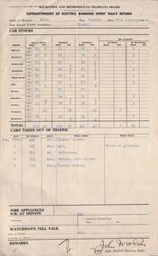
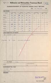
 Melbourne Tram Museum
Administrative record, Melbourne & Metropolitan Tramways Board (MMTB), "Supt running sheds daily return", 1938
... . Give details of the weather, traffic conditions, depot tram... of the weather, traffic conditions, depot tram cars - bogie and single ...Administrative record - "Superintendent electric running sheds' daily return" for MMTB dated 5/4/1938 - form 71 of 6/37. Give details of the weather, traffic conditions, depot tram cars - bogie and single truckers and the cars for the All Night services and their availability. Lists 6 cars taken out of service - defective or accidents, provides detail of status of fire services at depots, and watchmen's tell tales. Would have been compiled from individual depot reports. The rear of the sheet has been used to prepare notes on applicants for a position - Snesby? ,Fay, Hughes, Jones, Snout, Low, Quick and Coates giving details of seniority, service and Order from buses. See item 7521, 7516 and 7517 for similar reports. Yields information the mmtb cable tram allocation and events at electric tram running sheds - 1925 employee listing.Completed preprinted foolscap form with typed information and hand writing on the rear.tramways, trams, mmtb, depots, daily reports, employment -
 Running Rabbits Military Museum operated by the Upwey Belgrave RSL Sub Branch
Ikara Missile, Maribyrnong Ordinance Factory in Victoria. et al, 1965
... of weather conditions. Target information is fed into the fire... to the maximum range of the ships sonar, regardless of weather conditions ...During the 1950’s, the growing threat from Submarines, led the Royal Australian Navy to consider a quick reaction, long range ASW torpedo delivery system as an alternative to the USN’s ASROC and the RN’s Match. Full scale research and development began in 1960 using the Turana target drone as the basis for the delivery platform. Shipboard tests began in 1963 and the Government Aircraft Factory (GAF) began production of three variants M3, M4 and M5 in 1965. The M4 variant had a guidance system designed to interface to a full tactical data handling system while the M3 and M5 variants used a simpler system with a dedicated fire control system. The IKARA is an unmanned miniature aircraft with clip on upper and lower stabilizers and wings. The upper stabilizer (SVU) housed and electronic package that transmitted flight data back to the launch platform and received updated target acquisition data during flight. Flight maneuverability was provided by elevons fitted into the trailing edge of each wing, these were operated by an actuator system that received flight correction data transmitted to the autopilot from the fire control system. The payload, either the Mk44 or Mk46 lightweight torpedo was suspended to the underside of the airframe and faired into the body to provide and aerodynamic shape. The forward section of the body housed the autopilot and the thermal battery unit. Propulsion was provided by the MURAWA steel cased, solid propellant rocket motor with a combined boost and sustainer stage. IKARA was capable of engaging a target to the maximum range of the ships sonar, regardless of weather conditions. Target information is fed into the fire control system, which calculated to drop zone for the torpedo taking into account speed and direction of launch platform and target, win speed etc, then tracking the missile to the drop zone where command signals initiate torpedo release. The IKARA is an unmanned miniature aircraft with clip on upper and lower stabilizers and wings. navy, torpedo, rocket, submarine, missile -
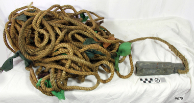 Flagstaff Hill Maritime Museum and Village
Equipment - Lead line
... line, day or night and in poor weather conditions. A standard... line, day or night and in poor weather conditions. A standard ...The lead line or hand lead is a simple navigational instrument used as a depth finder to measure the depth of water under the ship’s keel and to take samples of the sea bed. The long line may be marked at regular intervals with tags of different coloured and textured fabric, such as rope, leather and cloth. Each tag was a code to represent a certain depth. The leadsman’s eyes and hands could distinguish the depth easily as he drew in the lead line, day or night and in poor weather conditions. A standard set of codes for the tags was used so that the depth of the sea could be easily and quickly read. The measurement used was a Fathom, which equals 1.83 metres. The codes were: - 2 fathoms = 2 strips of leather 3 fathoms = 3 strips of leather 5 fathoms = white duck fabric 7 fathoms = red bunting fabric 10 fathoms = leather with a hole 13 fathoms = blue serge fabric 15 fathoms = white duck fabric 17 fathoms = red bunting 20 fathoms = 2 knots The lead weight could be between 7 -14 pounds (3.5 – 6.5kg) and the rope would be approximately 25 fathoms (45m). The hollowed-out end of the weight would hold a stick substance such as tallow or wax, which would pick up samples from the sea bed which would show whether the vessel was close to, or far away from, the shore. The leadsman would stand at the front of the vessel and cast the lead line into the sea. When it hit bottom he would note the tag marker nearest the surface of the water and call out his finding. Then he would haul it up again and examine the kind of matter that adhered to the end of the weight, whether it be sand, mud, gravel, or the colour of it. This information would be given to the ship’s helmsman or navigator and would help indicate the proximity to the land.This handheld lead is an example of early marine navigational equipment used by sailors to travel the seas to measure the depth of the water and sample the nature of the seabed. It helps to understand the history and progress made from the very basic to the sophisticated technology of today.Lead line, sounding line or depth finder. The long length of rope has a heavy lead weight attached to the end. Coloured fabric tags are tied onto the rope at regular intervals, representing different depths. The concave base of weight holds sticky substances such as tallow or beeswax, providing an adhesive surface to collect samples of sea bed like sand, shells or pebbles. flagstaff hill, warrnambool, shipwrecked coast, flagstaff hill maritime museum, maritime museum, shipwreck coast, flagstaff hill maritime village, lead line, depth finder, hand lead, sounding lin, leadsmane, navigation instrument, leadline, hand lead line -
 Melbourne Tram Museum
Administrative record, Melbourne & Metropolitan Tramways Board (MMTB), "Supt cable running sheds daily return", 1938
... . Give details of the weather, traffic conditions, depot tram... details of the weather, traffic conditions, depot tram cars - cars ...Administrative record - "Superintendent of cable running sheds daily return" for MMTB dated 21/2/1938 - form 21A of 11/37. Give details of the weather, traffic conditions, depot tram cars - cars and dummies, and their availability. Lists 2 cars taken out of service - issues or accidents. Would have been compiled from individual depot reports. The rear of the sheet has been used to prepare a report by K L Mackenzie on applicants for the Compressed Gas Plant attendant at Clifton Hill depot. The Compressed Gas plant was part of the equipment installed to provide gas for the buses during the early stage of the Second World War. Names listed are: Hence, Wrigly, Maynard, Fay, Coates, Stephens, Lyons, Langton, and C J M Campbell. See item 7521, 7517 and 7518 for similar reports. Yields information the mmtb cable tram allocation and events at cable tram running sheds - 1938.Completed preprinted quarto form with typed information with hand writing on rear.tramways, trams, mmtb, depots, daily reports, cable trams, clifton hill, compressed gas, buses -
 Melbourne Tram Museum
Administrative record, Melbourne & Metropolitan Tramways Board (MMTB), "Supt running sheds daily return", 1925
... details of the weather, traffic conditions, depot tram cars... of the weather, traffic conditions, depot tram cars - bogie and single ...Administrative record - "Superintendent electric running sheds' daily return" for MMTB dated 4/5/1925 - form 71. Give details of the weather, traffic conditions, depot tram cars - bogie and single truckers Lists 1 car taken out of service - defective or accidents, provides detail of the status of fire services at depots, and watchmen's tell tales. Would have been compiled from individual depot reports. The rear of the sheet has been used to prepare a report by K L Mackenzie on applicants for the Compressed Gas Plant attendant at Clifton Hill depot. The Compressed Gas plant was part of the equipment installed to provide gas for the buses during the early stage of the Second World War. Names listed are: Hence, Wrigly, Maynard, Fay, Coates, Stephens, Lyons, and Langton. See item 7521, 7516 and 7518 for similar reports. Yields information the mmtb cable tram allocation and events at electric tram running sheds - 1925 and the compressed gas system attendants.Completed preprinted foolscap form with typed information and hand writing on the rear.tramways, trams, mmtb, depots, daily reports, cable trams, clifton hill, compressed gas, buses -
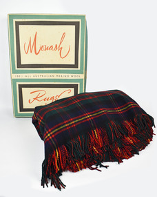 National Wool Museum
Textile - Rug, Returned Soldiers and Sailors Mill, 1963
... for use in these weather conditions and hence it stayed in its... for use in these weather conditions and hence it stayed in its ...The Returned Soldiers and Sailors Mills was located near the Barwon river on Pakington Street, Geelong, where its building still stands. The mill was established in October 1922 with capital acquired from War Gratuity Bonds. The mill produced fine grade woollen products with its speciality being ‘Retsol’ travelling rugs. The mill first began to run into financial troubles with the ‘Credit Squeeze’ or the ‘Holt Jolt’ of the early 1960s. This saw import restrictions lifted which triggered the start of a minor recession and a rise in unemployment. Included in these troubles was the RS&S Mill which saw the number of employees gradually decrease and business declining with cheaper imports beginning to grab an expanding part of the market share. The mill was eventually purchased by Godfrey Hirst in 1973 who tried to continue operations without success and in June 1975 textile production at the site ceased. Outside of financial considerations contributing to the closure of Woollen Mills in this period was the declining need for heavier fabrics as in-home heating and insulation improved. This need had been replaced for a demand for ever softer, finer and lighter worsted fabrics for more casual clothing. Modern day textile production requires fewer steps in the processing of materials for this use. This meant large factory complexes such as early woollen mills like the RS&S mills were no longer required. Compared to modern textile production which can spin a fine yarn out of synthetic fibre or imported cotton easily, spinning fine yarn from medium quality wool at a textile factory was cumbersome and no longer financially viable to suit new consumer demands. This rug provides context to this statement. It was gifted to Shirley and Gordon Green as a wedding present in November 1963 by one of Gordon's colleagues in the wool industry. Living in areas such as Neutral Bay, the Hornsby area and later in life retiring to the Central Coast, the blanket was too heavy for use in these weather conditions and hence it stayed in its original box for nearly 60 years. Top and bottom of rug has frilled edges. Pattern is titled the 'Clan Cameron' and is repeated in a 7x7 grid. Front of rug has a red background with 4 vertical and horizontal lines. All is surrounded by a yellow boarder. Label is stitched into the bottom right corner. Reverse of rug also has a repeating 7x7 grid. Blue background with thick green horizontal stripe. Yellow and red boarder to the grid with 4 red vertical and horizontal lines making up the interior. Rug measure 1550 x 2040mm, approximately the same size as a queen size mattress.Wording, Bottom right corner. THE GEELONG R.S&S. WOOLEN MILLS/ PURE/ WOOL/ AUSTRALIA/ The John Monash Rug (cursive)/ The Clan Cameron (cursive)rs&s mills, textile manufacture, rug, clan cameron, sydney greasy wool exchange -
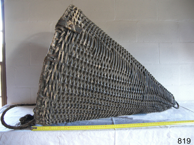
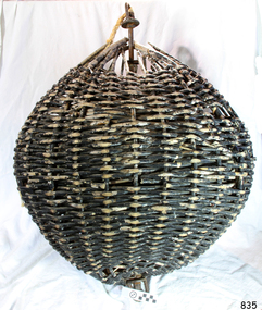
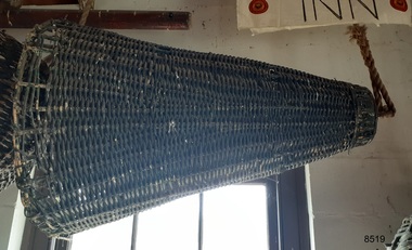
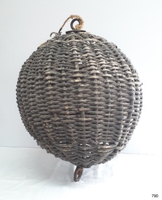 Flagstaff Hill Maritime Museum and Village
Equipment - Distant Signal, 1897-1931
... and weather conditions affected the visibility of the flags... and weather conditions affected the visibility of the flags ...This three-dimensional Distant Signal is part of a Flagstaff Signal set of ball, cone and drum shapes. It has been woven and then fabricated with strong metal swivel fittings and loops for suspending from a high point on a flagstaff at a signal station or on a ship’s masthead. The cane signal was constructed to withstand all weather and to be visible from a long distance. The gaps between the woven cane allow air to pass through, minimising possible swaying. Similar sets were made from rope or fabric. Warrnambool's Flagstaff was erected in 1854. Its primary use was to display visual signals that could convey messages between land and sea. It was also used to notify the local population of the approach of ships. One of the popular signalling codes in use in the early-to-mid 1800s was the Marryat’s Code but there were others in use as well; there was no one standard code. In 1857 the International Marine Conference adopted an International Code of Signals as a standard communications system for all vessels that could be understood in many different languages. The Normanby Advertiser reported on June 5th 1857 a query from the Post Master General as to whether the request of the Chief Harbour Master would be carried out, in that Warrnambool would receive a new flagstaff and a set of Marryatt’s signal flags. The Table of Codes was published, showing how to use combinations of these flags to send messages. The Code was revised in 1887 to cover situations where distance, light, wind and weather conditions affected the visibility of the flags and prevented clear communication. The first report of the International Code of Signals Committee of 1897 warned signalmen not to rely on ordinary semaphore flags and introduced a Distant Signal Code using either particular semaphore flags or the three-dimensional shapes of a ball, cone and drum that aligned with the semaphore flag shapes of a circle, pennant and square. International Code of Signals In 1931, after World War I’s experiences in using signal codes, the International Code of Signals conference in Washington revised and published the rules for the conduct of signalling. One of the changes was that “the use of the Distant Signals and of fixed semaphore was abandoned”. It is of interest to know that modern marine law in many countries insists that a set of Day Shapes must be carried onboard vessels of a certain size. These highly visible geometric shapes are used at sea in daylight to communicate messages between vessels. They are used in a similar way to the Distant Signals, in that different combinations of shapes represent different messages. The set of shapes includes a ball, cylinder, cone and diamond. The shapes are hung between the top of the vessel’s foremast and the front of the vessel. They are only coloured black and are about 1.5 metres high. The vertical line of shapes can mean messages such as Boat not under command, Fishing, and Under sail and power.Distant Signals were an important means of marine communication from the late 1880s to the early 1930s, including during World War I. They were an advancement to the International Shipping Codes and safety. The cane signals’ shapes appear to be the same from whatever direction they are viewed, removing confusion about the message they convey. The same shapes continue to be used today for the sets of Day Shapes used as marine navigational signals that are mandatory on certain-sized vessels.Distant Signal Ball, part of a Flagstaff signal set. A round woven cane ball, painted black, with a metal rod passing through the centre. The rod has a loop at each end, then a concave, octagonal metal plate that rests on the outside surface of the ball, serving as a washer. The rod has swivels at each end.flagstaff hill, flagstaff hill maritime museum and village, warrnambool, maritime museum, maritime village, great ocean road, shipwreck coast, distant signal, signal, maritime signal, ball signal, signal shape, flagstaff signal, signal station, masthead signal, communications, marine technology, signals, marine signals, flaghoists, international marine conference, international code of signals, signal codes, marine safety, signal flags, day shape, daymark, day symbol, navigation, warrnambool flagstaff, 1854, 1857 1931, 1887, 1897 -
 Flagstaff Hill Maritime Museum and Village
Equipment - Distant Signal, 1897-1931
... and weather conditions affected the visibility of the flags... and weather conditions affected the visibility of the flags ...This three-dimensional Distant Signal is part of a Flagstaff Signal set of ball, cone and drum shapes. It has been woven and then fabricated with strong metal swivel fittings and loops for suspending from a high point on a flagstaff at a signal station or on a ship’s masthead. The cane signal was constructed to withstand all weather and to be visible from a long distance. The gaps between the woven cane allow air to pass through, minimising possible swaying. Similar sets were made from rope or fabric. Warrnambool's Flagstaff was erected in 1854. Its primary use was to display visual signals that could convey messages between land and sea. It was also used to notify the local population of the approach of ships. One of the popular signalling codes in use in the early-to-mid 1800s was the Marryat’s Code but there were others in use as well; there was no one standard code. In 1857 the International Marine Conference adopted an International Code of Signals as a standard communications system for all vessels that could be understood in many different languages. The Normanby Advertiser reported on June 5th 1857 a query from the Post Master General as to whether the request of the Chief Harbour Master would be carried out, in that Warrnambool would receive a new flagstaff and a set of Marryatt’s signal flags. The Table of Codes was published, showing how to use combinations of these flags to send messages. The Code was revised in 1887 to cover situations where distance, light, wind and weather conditions affected the visibility of the flags and prevented clear communication. The first report of the International Code of Signals Committee of 1897 warned signalmen not to rely on ordinary semaphore flags and introduced a Distant Signal Code using either particular semaphore flags or the three-dimensional shapes of a ball, cone and drum that aligned with the semaphore flag shapes of a circle, pennant and square. International Code of Signals In 1931, after World War I’s experiences in using signal codes, the International Code of Signals conference in Washington revised and published the rules for the conduct of signalling. One of the changes was that “the use of the Distant Signals and of fixed semaphore was abandoned”. It is of interest to know that modern marine law in many countries insists that a set of Day Shapes must be carried onboard vessels of a certain size. These highly visible geometric shapes are used at sea in daylight to communicate messages between vessels. They are used in a similar way to the Distant Signals, in that different combinations of shapes represent different messages. The set of shapes includes a ball, cylinder, cone and diamond. The shapes are hung between the top of the vessel’s foremast and the front of the vessel. They are only coloured black and are about 1.5 metres high. The vertical line of shapes can mean messages such as Boat not under command, Fishing, and Under sail and power.Distant Signals were an important means of marine communication from the late 1880s to the early 1930s, including during World War I. They were an advancement to the International Shipping Codes and safety. The cane signals’ shapes appear to be the same from whatever direction they are viewed, removing confusion about the message they convey. The same shapes continue to be used today for the sets of Day Shapes used as marine navigational signals that are mandatory on certain-sized vessels.Distant Signal Cone, part of a Flagstaff signal set. A woven cane cone, painted black, with a metal rod passing through the centre and two crossed metal bars at the base. The central rod has a loop at the top and passes through the bars at the base, finishing in a metal loop. The rod has swivels at each end.flagstaff hill, warrnambool, flagstaff hill maritime museum and village, shipwreck coast, marine navigation, marine communications, communication signal, lifesaving, ship at sea, day shape, masthead signal, day signal, day mark signals, marine technology, safety equipment, navigation equipment, marine day shape, day marker, cane day shape, signal cone, day signal cone, cone signal, cone day shape, distant signal, flagstaff signal, signal station, communications, signals, marine signals, flaghoists, international marine conference, international code of signals, signal codes, marine safety, signal flags, daymark, day symbol, navigation, warrnambool flagstaff, 1854, 1857 1931, 1887, 1897 -
 Flagstaff Hill Maritime Museum and Village
Equipment - Distant Signal, 1897-1931
... and weather conditions affected the visibility of the flags... and weather conditions affected the visibility of the flags ...This three-dimensional Distant Signal is part of a Flagstaff Signal set of ball, cone and drum shapes. It has been woven and then fabricated with strong metal swivel fittings and loops for suspending from a high point on a flagstaff at a signal station or on a ship’s masthead. The cane signal was constructed to withstand all weather and to be visible from a long distance. The gaps between the woven cane allow air to pass through, minimising possible swaying. Similar sets were made from rope or fabric. Warrnambool's Flagstaff was erected in 1854. Its primary use was to display visual signals that could convey messages between land and sea. It was also used to notify the local population of the approach of ships. One of the popular signalling codes in use in the early-to-mid 1800s was the Marryat’s Code but there were others in use as well; there was no one standard code. In 1857 the International Marine Conference adopted an International Code of Signals as a standard communications system for all vessels that could be understood in many different languages. The Normanby Advertiser reported on June 5th 1857 a query from the Post Master General as to whether the request of the Chief Harbour Master would be carried out, in that Warrnambool would receive a new flagstaff and a set of Marryatt’s signal flags. The Table of Codes was published, showing how to use combinations of these flags to send messages. The Code was revised in 1887 to cover situations where distance, light, wind and weather conditions affected the visibility of the flags and prevented clear communication. The first report of the International Code of Signals Committee of 1897 warned signalmen not to rely on ordinary semaphore flags and introduced a Distant Signal Code using either particular semaphore flags or the three-dimensional shapes of a ball, cone and drum that aligned with the semaphore flag shapes of a circle, pennant and square. International Code of Signals In 1931, after World War I’s experiences in using signal codes, the International Code of Signals conference in Washington revised and published the rules for the conduct of signalling. One of the changes was that “the use of the Distant Signals and of fixed semaphore was abandoned”. It is of interest to know that modern marine law in many countries insists that a set of Day Shapes must be carried onboard vessels of a certain size. These highly visible geometric shapes are used at sea in daylight to communicate messages between vessels. They are used in a similar way to the Distant Signals, in that different combinations of shapes represent different messages. The set of shapes includes a ball, cylinder, cone and diamond. The shapes are hung between the top of the vessel’s foremast and the front of the vessel. They are only coloured black and are about 1.5 metres high. The vertical line of shapes can mean messages such as Boat not under command, Fishing, and Under sail and power.Distant Signals were an important means of marine communication from the late 1880s to the early 1930s, including during World War I. They were an advancement to the International Shipping Codes and safety. The cane signals’ shapes appear to be the same from whatever direction they are viewed, removing confusion about the message they convey. The same shapes continue to be used today for the sets of Day Shapes used as marine navigational signals that are mandatory on certain-sized vessels.Distant Signal Ball, part of a Flagstaff signal set. A round woven cane ball, painted black, with a metal rod passing through the centre. The rod has a loop at each end, then a concave, octagonal metal plate that rests on the outside surface of the ball, serving as a washer. The rod has swivels at each end.flagstaff hill, warrnambool, flagstaff hill maritime museum and village, shipwreck coast, marine navigation, marine communications, communication signal, lifesaving, ship at sea, day shape, masthead signal, day signal, day mark signals, marine technology, safety equipment, navigation equipment, marine day shape, day marker, cane day shape, signal ball, day signal ball, ball signal, ball day shape, distant signal, flagstaff signal, signal station, communications, signals, marine signals, flaghoists, international marine conference, international code of signals, signal codes, marine safety, signal flags, daymark, day symbol, navigation, warrnambool flagstaff, 1854, 1857 1931, 1887, 1897 -
 Flagstaff Hill Maritime Museum and Village
Equipment - Distant Signal, 1897-1931
... and weather conditions affected the visibility of the flags... and weather conditions affected the visibility of the flags ...This three-dimensional Distant Signal is part of a Flagstaff Signal set of ball, cone and drum shapes. It has been woven and then fabricated with strong metal swivel fittings and loops for suspending from a high point on a flagstaff at a signal station or on a ship’s masthead. The cane signal was constructed to withstand all weather and to be visible from a long distance. The gaps between the woven cane allow air to pass through, minimising possible swaying. Similar sets were made from rope or fabric. Warrnambool's Flagstaff was erected in 1854. Its primary use was to display visual signals that could convey messages between land and sea. It was also used to notify the local population of the approach of ships. One of the popular signalling codes in use in the early-to-mid 1800s was the Marryat’s Code but there were others in use as well; there was no one standard code. In 1857 the International Marine Conference adopted an International Code of Signals as a standard communications system for all vessels that could be understood in many different languages. The Normanby Advertiser reported on June 5th 1857 a query from the Post Master General as to whether the request of the Chief Harbour Master would be carried out, in that Warrnambool would receive a new flagstaff and a set of Marryatt’s signal flags. The Table of Codes was published, showing how to use combinations of these flags to send messages. The Code was revised in 1887 to cover situations where distance, light, wind and weather conditions affected the visibility of the flags and prevented clear communication. The first report of the International Code of Signals Committee of 1897 warned signalmen not to rely on ordinary semaphore flags and introduced a Distant Signal Code using either particular semaphore flags or the three-dimensional shapes of a ball, cone and drum that aligned with the semaphore flag shapes of a circle, pennant and square. International Code of Signals In 1931, after World War I’s experiences in using signal codes, the International Code of Signals conference in Washington revised and published the rules for the conduct of signalling. One of the changes was that “the use of the Distant Signals and of fixed semaphore was abandoned”. It is of interest to know that modern marine law in many countries insists that a set of Day Shapes must be carried onboard vessels of a certain size. These highly visible geometric shapes are used at sea in daylight to communicate messages between vessels. They are used in a similar way to the Distant Signals, in that different combinations of shapes represent different messages. The set of shapes includes a ball, cylinder, cone and diamond. The shapes are hung between the top of the vessel’s foremast and the front of the vessel. They are only coloured black and are about 1.5 metres high. The vertical line of shapes can mean messages such as Boat not under command, Fishing, and Under sail and power.Distant Signals were an important means of marine communication from the late 1880s to the early 1930s, including during World War I. They were an advancement to the International Shipping Codes and safety. The cane signals’ shapes appear to be the same from whatever direction they are viewed, removing confusion about the message they convey. The same shapes continue to be used today for the sets of Day Shapes used as marine navigational signals that are mandatory on certain-sized vessels.Distant Signal Cone, part of a Flagstaff signal set. A woven cane cone, painted black, with a metal rod passing through the centre and two crossed metal bars at the base. The central rod has a loop at the top and passes through the bars at the base, finishing in a metal loop. The rod has swivels at each end.flagstaff hill, warrnambool, flagstaff hill maritime museum and village, shipwreck coast, marine navigation, marine communications, communication signal, lifesaving, ship at sea, day shape, masthead signal, day signal, day mark signals, marine technology, safety equipment, navigation equipment, marine day shape, day marker, cane day shape, signal cone, day signal cone, cone signal, cone day shape, distant signal, flagstaff signal, signal station, communications, signals, marine signals, flaghoists, international marine conference, international code of signals, signal codes, marine safety, signal flags, daymark, day symbol, navigation, warrnambool flagstaff, 1854, 1857 1931, 1887, 1897 -
 Flagstaff Hill Maritime Museum and Village
Equipment - Distant Signal, 1897-1931
... and weather conditions affected the visibility of the flags... and weather conditions affected the visibility of the flags ...This three-dimensional Distant Signal is part of a Flagstaff Signal set of ball, cone and drum shapes. It has been woven and then fabricated with strong metal swivel fittings and loops for suspending from a high point on a flagstaff at a signal station or on a ship’s masthead. The cane signal was constructed to withstand all weather and to be visible from a long distance. The gaps between the woven cane allow air to pass through, minimising possible swaying. Similar sets were made from rope or fabric. Warrnambool's Flagstaff was erected in 1854. Its primary use was to display visual signals that could convey messages between land and sea. It was also used to notify the local population of the approach of ships. One of the popular signalling codes in use in the early-to-mid 1800s was the Marryat’s Code but there were others in use as well; there was no one standard code. In 1857 the International Marine Conference adopted an International Code of Signals as a standard communications system for all vessels that could be understood in many different languages. The Normanby Advertiser reported on June 5th 1857 a query from the Post Master General as to whether the request of the Chief Harbour Master would be carried out, in that Warrnambool would receive a new flagstaff and a set of Marryatt’s signal flags. The Table of Codes was published, showing how to use combinations of these flags to send messages. The Code was revised in 1887 to cover situations where distance, light, wind and weather conditions affected the visibility of the flags and prevented clear communication. The first report of the International Code of Signals Committee of 1897 warned signalmen not to rely on ordinary semaphore flags and introduced a Distant Signal Code using either particular semaphore flags or the three-dimensional shapes of a ball, cone and drum that aligned with the semaphore flag shapes of a circle, pennant and square. International Code of Signals In 1931, after World War I’s experiences in using signal codes, the International Code of Signals conference in Washington revised and published the rules for the conduct of signalling. One of the changes was that “the use of the Distant Signals and of fixed semaphore was abandoned”. It is of interest to know that modern marine law in many countries insists that a set of Day Shapes must be carried onboard vessels of a certain size. These highly visible geometric shapes are used at sea in daylight to communicate messages between vessels. They are used in a similar way to the Distant Signals, in that different combinations of shapes represent different messages. The set of shapes includes a ball, cylinder, cone and diamond. The shapes are hung between the top of the vessel’s foremast and the front of the vessel. They are only coloured black and are about 1.5 metres high. The vertical line of shapes can mean messages such as Boat not under command, Fishing, and Under sail and power.Distant Signals were an important means of marine communication from the late 1880s to the early 1930s, including during World War I. They were an advancement to the International Shipping Codes and safety. The cane signals’ shapes appear to be the same from whatever direction they are viewed, removing confusion about the message they convey. The same shapes continue to be used today for the sets of Day Shapes used as marine navigational signals that are mandatory on certain-sized vessels.Distant Signal Ball, part of a Flagstaff signal set. A round woven cane ball, painted black, with a metal rod passing through the centre. The rod has a loop at each end, then a concave, octagonal metal plate that rests on the outside surface of the ball, serving as a washer. The rod has swivels at each end.distant signal, flagstaff signal, signal station, masthead signal, communications, marine technology, signals, marine signals, flaghoists, international marine conference, international code of signals, signal codes, marine safety, signal flags, day shape, daymark, day symbol, navigation, warrnambool flagstaff, 1854, 1857 1931, 1887, 1897 -
 Kiewa Valley Historical Society
Photographs and copies of photographs of the pack horses and early horsemen who transported supplies to outposts in the Bogong High Plains, via cattle tracks before access roads were made
... weather and living conditions of bush camping, often arriving... weather and living conditions of bush camping, often arriving ...In the mid to late 1930’s survey outposts were established to plot the early stages of the Kiewa Hydro Electric System for the SECV in the Bogong High Plains. Before any roads were built, the old cattleman’s tracks were used with packhorses to deliver supplies, wages and mail and collect timesheets and correspondence from the workmen and dam builders living in canvas tents and at the outlying survey posts. The trip up the mountain was long and hard and dangerous for both horse and man Most of the men of the survey teams were not bush-men and were often ill equipped for the harsh weather and living conditions of bush camping, often arriving in their city clothes ready for work. The tent city at Bogong was destroyed by bush fires in 1939 after which an access road was built from Mt Beauty to transport building materials for more permanent dwellings for workmen. Pack horses continued to be used for transporting goods etc. to workers further up the mountain.Without the work of horsemen and their pack horses providing supplies and communications for outlying outposts, surveying and early planning for the Kiewa Valley Hydro Electric scheme could not have gone ahead and the dams and power stations which support the system could not have been constructed. The Hydro-electric scheme, and the workers who planned and built it play a major part in the early history of the Kiewa Valley and many original families still remain living, or have ties with the local area.: Set of 21 black and white photographs and copies of photographs depicting the pack horses and the men who handled them, transporting supplies and correspondence to the outlying camps and survey posts in the Bogong High Plains, via the rough cattlemen’s tracks. Photographs also show the early tent camps of the workers. Some photos mounted on A4 white paper. Some photos enlarged to A3 poster size for display1. Handwritten on back – Max Lawrence 2. -8 No inscriptions 9. Handwritten on back- Packing in supplies for early workers of the Kiewa Hydro scheme. There were no roads in the early days of the scheme 10. Printed on bottom of photo- Roper’s cattle on road below Howman’s Gap 11. Handwritten on back – Roper’s et al about to leave for the high plains 12. Printed under photo- Syd Ryder at the Pretty Valley Cut-Out (JBR) 13-16. No markings 17. Printed under photo- Gwen Talbot visits the Camp area. 1937 18. Handwritten on back- 14/1 Barbara Talbot 19. No markings 20-21. No markings 22. Printed under photo- STATE ELECTRICITY COMMISSION OF VICTORIA. Date: 15-3-45 Time: 8.0pm No: K 1838 Kiewa Hydro-Electric Works, Investigations 1944-1945 – Survey Camp at Young’s Hut pack horses; bogong high plains; survey posts; supplies delivery -
 Flagstaff Hill Maritime Museum and Village
Functional object - Lamp Light, late 19th - early-20th century
... lit, sometimes with little success due to weather conditions... to weather conditions and the pranks of youths. WARRNAMBOOL ...This gas lamp light and stand came from the original manufacturer in Melbourne. Gas street lights such as this one were used in Melbourne from the mid-19th century. The lights enabled safer after-dark travel for pedestrians and vehicles and were a deterrent to crime. A lamp lighter was employed to keep the lamps lit, sometimes with little success due to weather conditions and the pranks of youths. WARRNAMBOOL Gasworks In Warrnambool prior to 1874 there were about twenty rare, individually lit street lights in Warrnambool, each with its own supply of kerosene. These lamps were in the central business area of Timor, Koroit and Liebig Streets. The Warrnambool Gas Company Ltd. was registered as an incorporated company in 1873. It was a private, locally owned business. It was located at 209-215 Merri Street, Warrnambool, on the land, which is just west of the later-built railway station. The first managers of the Gas Company lived in a substantial stone house on site, but later the managers lived in a residence in Henna Street between Merri and Timor Streets. The original home, which still stands, became a residence for the Railway Station Master from about 1890. In August 1874 the construction of the gasworks was complete and at the end of that month gas was supplied to all of the existing lamps in Warrnambool for the first time. The Warrnambool Gas Company wound up in 1880-1881 and was purchased by the Warrnambool Borough Council with money raised by a loan – the Borough’s first ‘loan transaction’. The Council established a piped network to supply gas to other street connections. The gasworks were privatised and upgraded in 1952. In 1972 the town supply was converted to liquid petroleum gas and by the early 1980s the gasworks were closed down. In 1986 Warrnambool was supplied with natural gas from a site near Port Campbell. The Warrnambool gasworks supplied all street and shop lighting and most domestic lighting until 1923 when electricity was available for lighting. Bromfield Street in Warrnambool was named after the director of the gasworks, James Astley Bromfield (1823-1903). He arrived in Warrnambool from Worcestershire, England, in 1852 and was very active in the local council and community. Cockman Street was named after the first secretary of the gasworks in 1874, Walter Cockman (c.1821-1892). He was a Mayor and businessman. The second Manager, Luther Rodgers, worked for the gas company for about twenty years and both Rodger Place and Rodgers Road in Warrnambool have been named after him. LAMP LIGHTS IN MELBOURNE In the 1820s Melbourne's innkeepers were legally required to have a lamp light outside their premises from sunset to sunrise. This was the first instance of street lamps being used in Melbourne. In 1847 the first oil lamp was used in the city. In 1849 a gas lamp was installed on the Swanston Street Bridge and much of the city had oil lamps installed by then. In August 1857 the installation of street gas lamps began in Melbourne. They were welcomed for the much brighter illumination they gave. By 1860 there were 414 lamp pillars. The phrase was quoted often - "A light was as good as a policeman". The first gas burners used for street lighting were called 'fishtail' gas burners. These were replaced in the early 1900s by gas mantles. The City of Melbourne Gas Coke Company was formed in 1850 but due to the Gold Rush the manufacture and distribution of the gas supply was delayed until January 1856. By the 1890s the gas supplying the lights was supplied by three companies in Melbourne. In 1879 a football match was played at the MCG under electric lighting and gradually electric arc lights were installed inside and outside buildings in the city. Lamp lights such as the one in Flagstaff Hill’s collection were no longer needed. (References: John Lindsay re Lamp Light history 2019-01-29, Former Warrnambool Gas Company Limited, Victorian Heritage Database Report, Heritage Number 149746 https://vhd.heritagecouncil.vic.gov.au/places/149746/download-report ) The lamp light is representative of the lamps used in Melbourne from the mid-nineteenth century to light the streets at night and make Melbourne a safer city. The lamp is also representative of the gas street lighting in Warrnambool from the mid-1870s-1920s.Lamp light or gas light. Street light, one of the last gas street lights removed from Melbourne. (Reconditioned by Friends of Flagstaff Hill, 2013)flagstaff hill, warrnambool, shipwrecked coast, flagstaff hill maritime museum, maritime museum, shipwreck coast, flagstaff hill maritime village, great ocean road, lamp light, gas light, gas lamp, street lamp, street light, gas street light, melbourne street lighting, warrnambool street lighting, melbourne gas street light, warrnambool gas company, warrnambool gasworks, james bromfield, walter cockman, luther rodgers, city of melbourne gas coke company -
 Bendigo Historical Society Inc.
Letter - MERLE HALL COLLECTION: ROSALIND PARK CREATIVE VILLAGE BENDIGO PROJECT LETTERS, 1994
... 1997, unless severe weather conditions make the laying... 1997, unless severe weather conditions make the laying ...Merle Hall Collection: Rosalind Park Creative Village Bendigo Project Letters 31 March 1994 To: Victorian Arts Council Members From Grant Finck Project Coordinator Content: Introduces himself as the coordinator for 12 months; to members looking for expression of interest, includes Information Sheet 1994 on what the Creative Village is. 27 October 1995 To: Mrs. Mearle Hall From: City of Greater Bendigo, Bernard Smith (Director Environmental Services) Content: Granting access to the Victoria Hill site for small quantities of geological material. 10 January 1996 To: Mrs. Mearle Hall From: City of Greater Bendigo, Bernard Smith (Director Environmental Services) Content: Endorsement of the project by the Council and confirmation that the Council will provide preliminary site work to allow the project to be enabled. Also advised the Arts Bendigo Mosaic Project makes contact with the Salvation Army (New Work Opportunity Project) 27 February 1996 To: Mrs. Mearle Hall From: Ken Beasley Manager Project Development The Smith Read Training Group. Content: LEAP Project Proposal - Mining Heritage Mosaic outlining the benefits of using LEAP Trainees to undertake the project. Proposed Scope of work outlining responsibilities of each participant. Bendigo Mining NL Environmental Trust Fund (Perseverance Exploration and Department of Energy and Minerals Victoria representatives) 27 June 1996 To: Mrs. Mearle Hall From: City of Greater Bendigo, Bernard Smith (Director Environmental Services) Content: Advising that the Council will match dollar for dollar funding for the engagement of an artist to supervise the construction of the Mosaic in Upper Rosalind Park up to $3,500. 22 July 1996 To: Anne Buzza From Geof Brown Camp Hill Primary School Content: Thanks for using and managing the school students to help create tiles. 9 October 1996 To: Mrs. Mearle Hall From: City of Greater Bendigo, Bernard Smith (Director Environmental Services) Content: Enclosed cheque for matching grant of $3500 15 October 1996 To: Mrs. Mearle Hall From: City of Greater Bendigo, Bernard Smith (Director Environmental Services) Content: Agreement to relocate the project facilities to the car park and to maintain a close liaison between the Council and Arts Bendigo. 13 November 1996 To: Mrs. Mearle Hall From: The Sidney Myer Fund Helen Morris Research Officer Content: Remittance advice for $1000 22 April 1997 To: Mrs. Mearle Hall From: John Little Administrator Victorian Arts Council Content: Remittance advice for $500 towards the project and enclosing 12 VAC Annual reports. 20 October 1998 To: Mrs. Mearle Hall From: City of Greater Bendigo, Andrew Hall (Director Community Development) Content: Advising that the Council will make a grant of $1090 for the purpose of printing of Brochures for Bendigo Heritage Mosaic. A service agreement to be signed before the issue of the grant, 21 March 2001 To: Mrs. Mearle Hall From: City of Greater Bendigo, Justin Hanney (Director Community Services) Content: A reference from Council supporting the project application to Vic Health for the development of a series of small mosaic pieces along the linear pathway asjacent to the Bendigo Creek. 12 November 1996 To: Mrs. Mearle Hall From: Arts Bendigo Inc. Content: Cheque for $2000 being first payment as under contract two for mosaic project. 4 December 1996 To: Mrs. Mearle Hall From: Arts Bendigo Inc. Content: Cheque for $2000 being second payment as under contract two for mosaic project. 27 July 1997 To: Maery Gabriel Mosaic Artist From: Arts Bendigo Inc. Content: Cheque for $2000 being final payment as under contract two for mosaic project. 12 June 1997 - Two copies To: Maery Gabriel Mosaic Artist From: Arts Bendigo Inc. Content: Agreement between Maery Gabriel (The artist) and Arts Bendigo Inc. to complete the final two sections of the Bendigo Heritage Mosaic at the base of the Rosalin Park Poppet Head, Bendigo with a design of approximately two square meters within each section. The work to be completed by the endo of July 1997, unless severe weather conditions make the laying impossible. Agreement for two lots of $2000. 14 June 1996 From: Maery Gabriel Mosaic Artist To: Arts Bendigo Inc. Content: receipt for 50% payment for two weeks and $60 Travelling expenses. 21 May 1996 Agreement between Arts Bendigo of P.O Box 563, Bendigo in the State of Victoria (hereinafter referred to as the ‘AB’ of the first part AND Meary Hall of Morningswood, Petersons Road, Ellinbank, 3821 in the State of Victoria (hereinafter referred to as ‘the artist’) of the second part. ENGAGEMENT: (a) AB engages the Artist to provide her services as Mosaic Artist for the design and creation of a Mosaic pavement surround to the poppet head lookout in Rosalind Park, Bendigo and matters incidental thereto at such schools, halls and any other places as required from time to time by AB and the Artist accepts the engagement upon the term and conditions hereinafter appearing. (b) Services to be provided by the artist include community consultation and design work in association with AB Co-Ordinator and Arts Bendigo, a minimum of six weeks of the artist’s time within the six months of the project. Completion of section one of the whole design with further work on the other sections to depend on available funding. The agreed fee was $5400 and $60 per visit to Bendigo with living away to be provided by Arts Bendigo 1 November 1996 Agreement between Arts Bendigo of P.O Box 563, Bendigo in the State of Victoria (hereinafter referred to as the ‘AB’ of the first part AND Meary Hall of Morningswood, Petersons Road, Ellinbank, 3821 in the State of Victoria (hereinafter referred to as ‘the artist’) of the second part. ENGAGEMENT: (a) AB engages the Artist to provide her services as Mosaic Artist for the design and creation of a Mosaic pavement surround to the poppet head lookout in Rosalind Park, Bendigo and matters incidental thereto at such schools, halls and any other places as required from time to time by AB and the Artist accepts the engagement upon the term and conditions hereinafter appearing. (b) Services to be provided by the artist include community consultation and design work in association with AB Co-Ordinator and Arts Bendigo, a minimum of six weeks of the artist’s time within the six months of the project. Completion of section one of the whole design with further work on the other sections to depend on available funding. The agreed fee was $5000 and $60 per visit to Bendigo with living away to be provided by Arts Bendigo, plus transfer of the diamond saw purchased by AB 28 August 1996 Memorial to Bendigo’s Mining Heritage and Traditions financial and other support as at August 128th Arts Bendigo Financial contribution: $7000 Local Busine Sponsors: $2800 City of Greater Bendigo Matching Above: $2800 City of Greater Bendigo Site works: Equiv, $12000 Local Businesses and institutions supplying goods and services to total value of: Equiv: $7600 Expenditure: Purchase of equipment, including diamond saw: $2000 Purchase of materials: $800 Artists design fees: $3000 Artists on site work, travel and accommodation: $12000 insurance, administration etc.: $700 31 May 1996 List of possible donors' checklist Undated Budget Sheet 21 September 1995 From: The Victorian Arts Council To: City of Greater Bendigo Content: Invoice for $5000 10 December 1995 From: Maery Gabriel artist To: Arts Bendigo Content: Invoice $1575 for design of Rosalind Park Lookout. 45 hours @ $35/hour 1 October 1996 Historic mining Mosaic Pavement, Rosalind Park Poppet Head Financial Statement as a October 1st, 1996 28 October 1996 From: Maery Gabriel To: Ann Buzza (representing Arts Bendigo) Report on project of Rosalind Park Mosaic as at October 1996. The report lists the difficulties faced with the weather, unsuitable facilities on site and problems with the LEAP team labour.victorian arts council, city of greater bendigo -
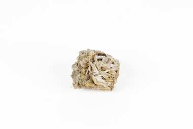 The Beechworth Burke Museum
Geological specimen - Cerussite, Unknown c.1890s
Named in 1845 by Wilhelm Karl von Haidinger cerussite takes its name from the Latin cerussa, meaning 'white lead'. When viewed under certain lighting conditions cerussite gives of fire and rainbow-like colours (due to its high dispersion) and it is quite sought after by geological collectors for this very reason. Cerussite is usually found in the oxidised zone of lead ore deposits. It is a very common weathering product of galena and other lead ore minerals. It is a secondary mineral, meaning it forms as a result of the alteration of pre-existing minerals in the Earth’s crust. The presence of lead in cerussite makes it potentially toxic. Historically, it has been an important source of lead, which has numerous industrial applications, including in batteries, construction materials, and radiation shielding. Cerussite has a crystal structure that belongs to the orthorhombic crystal system. Its crystal structure is characterized by a three-dimensional arrangement of atoms in a repeating pattern. The crystal lattice of cerussite consists of interconnected lead (Pb) and carbonate (CO3) ions. This crystal structure is visible in the specimen. This specimen was found in Dundas (formerly Mount Dundas), a historical mining locality, mineral field and railway located on the western foothills of the West Coast Range in Western Tasmania. During the 1890s Dundas swelled in numbers however it is now lost in a temperate rainforest and its population is now 2. The present Dundas Extended mine, about 1.5 km east of Dundas is presently worked for specimen material.Faceted cerussite gems are considered rare and valuable, given the softness of the mineral. This item is not a faceted gem however its historical and scientific research potential give it significance; mined in an Australian township, this cerussite could shed light on the now lost history of Dundas and the mining that occurred there. Additionally, the uses of this mineral in historical industrial processes give it scientific significance. Such knowledge can add to understandings of the geographical and geological nature of Western Tasmania and allow for further study of Australian geological specimens. A small lead carbonite mineral with shades of cream, white and brown throughout, flaky shards of white at base. CERUSSITE / (lead carbonite) / Locality: Dundas, W. Tasmaniadundas, tasmania, cerussite, lead, orthorhombic, geology, minerals, mining -
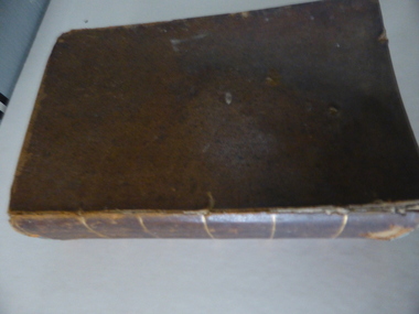 Warrnambool and District Historical Society Inc.
Book, A Complete Epitome of Practical Navigation - J W Norie, 1848
This book is a 19th Century treatise on aids to navigation. It belonged to John Cowtan who held land near the Cassady's Bridge area in Caramut Road today (he was related to the Cassady family) and who is mainly important in the history of Port Fairy. Captain John Cowtan was a ship's master for John Griffiths and a Launceston entrepreneur and ship owner between 1839 and 1844. In 1847 he went into partnership with John Bland, establishing a merchant's business with riverside buildings at the Port Fairy wharf. He left Port Fairy in the 1860s. The date of John Cowtan's signature in this book is 1849 (certainly a very early one in our history) and inside the front cover he has written notes about the local weather, mainly as it affected sailing conditions in late 1849 and early 1850. These notes are of great historical interestThis book is of great interest because it belonged to a Port Fairy historical figure and because of the hand written weather notes inside the front cover. This is a hard covered,leather bound book of 680 pages. It contains printed text, illustrations, tables, maps and sketches.One page is torn Some pages are stained. . J Cowtan 1849john cowtan, port fairy -
 Kiewa Valley Historical Society
Papers - Mt Bogong (Two articles), Australian & New Zealand Ski Year Book: 1. Pages 91-94 and 2. Pages 45 -55
Mt Bogong is visited all year round. In 1936 Cleve Cole died after having been lost in a blizzard close to its summit. This resulted in the erection of snow poles and the Cleve Cole Hut.Mt Bogong, the highest mountain in Victoria, used by skiers in winter and bushwalkers in summer. The weather is variable.1. Article includes 'New Summit Hut' & includes effect of cattle on skiing conditions - 4 pages stapled top left corner 2. The Mt Bogong Disaster, 1936 Cleve Cole, Rescue. 10 pages stapled top left cornercleve cole, mt bogong, summit hut, snow, skiing disaster. -
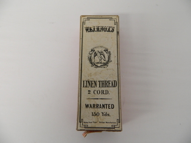 Kiewa Valley Historical Society
Box Linen Thread, early to mid 1900's
This box which once contained linen thread manufactured in Scotland and labelled "British" manufacture" was used for the repair/manufacture of clothing by professional seamstresses and those wives required to "do" repair stitching of family clothes. This box was manufactured in a period when the title "United Kingdom" was used (late 1700's early 1900's) to describe the union of Britain and Scotland. The label however can be misleading as the"British Manufacture" thread was manufactured in Scotland. The broad term "British Manufacture" was used for the benefit of those in the "colonies" of Australia and New Zealand, during a period when the "coined" phrase "best of British, or British best" was synonymous to "top quality". After World War II the need for "cheaper products" was more persuasive than the quality of the product. In rural areas this shift to cheaper "non British" goods was at a slower rate than in the cities. Goods such as clothing manufactured or altered by seamstresses were regarded as of a higher standard and therefor the use of linen thread from "Britain" was a sign of quality and reliability.This box which contained linen thread, "British" made, is very significant to the Kiewa Valley because it demonstrates the conditions under which households in the late 1800's and early 1900's evolved from a "domestic repair /replacement" of damaged clothing to a consumer of recycled and shop bought clothing and linen. The ability of semi isolated rural based families to purchase "off the rack" clothing was severely affected by weather, long distance over dirt roads(poorly serviced) to large towns(shops), horse/cart or slower driven cars. The purchasing of clothing was, on the whole, from trading house "mail order" consignment orders.This red paper covered box has a white covered lid (top) with black print detailing the manufacturer and contents. This box contained 150 yds of linen thread 2 cord. A small added note pasted on one side "USUAL TWIST (s)" describing the thread's appearance. Two semicircular "finger" holes on two sides of the lid permit easier removal of the lid from the base.On the top lid: "W.&J. KNOX'S" below this a crest with latin motive "MOVEO ET PROFICIOR" English translation "I proceed and am more prosperous" encircling an open winged falcon. below this "LINEN THREAD", "2 CORD." "WARRANTED" "150 Yds." Made from Flax." British Manufacture". On one side "DRABS SOFT FINISH" within a shield "KNOX'S TWO CORD 150 YARDS 30" next to this a trade mark "W & J KNOX below this "made in KILBIRNIE, SCOTLAND"thread, cord. flax, box container, linen thread, seamstress items, cardboard box -
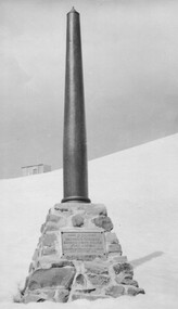 Kiewa Valley Historical Society
Photo: Memorial on the Staircase Spur Track, Mt Bogong
Mt Bogong is the highest mountain in Victoria. The Staircase Spur track to its top starts at Mountain Creek Road going through forest and continuing above the snow line to grass land. The weather can change very quickly with cloud and snow making conditions dangerous. Large sepia photo of the Memorial in snow on the Staircase Spur Track on Mt Bogong. The Memorial has a plaque attached: Sacred to the Memory / of Georgine Gadsden / Edward Neave Welch / John McRae / who perished here during a blizzard / about August 2nd 1943staircase spur memorial, mt bogong -
 Flagstaff Hill Maritime Museum and Village
Painting - Oil painting, W. Langley-Taylor, Eagle Rock, Warrnambool, Vic, Late 19th to early 20th century
This painting is one of a pair of large paintings by W. Langley-Taylor in our collection. Currently, no further information has been found about the artist but research is ongoing. The subjects of these paintings are seascapes of notable areas of the coast on each side of Port Phillip Bay, south of Melbourne, Victoria. This painting is of Eagle Rock, Warrnambool, which is on the west of Port Phillip Bay. Eagle Rock is located about 400 metres west of Thunder Point, near Shelly Beach. The painting includes the rocky cliff formations looking east towards the Warrnambool Breakwater. The walk from the Thunder Point car park westwards to Shelly Beach has been popular over the decades with residents as well as tourists. Many photographs include the rock, with varying backgrounds depending on the angle of the camera. It is a popular dive site for locals and visitors, in calm weather! The site can be approached by boat from the open sea in favourable conditions, and there is plenty of native marine to be seen in this marine sanctuary. This part of Warrnambool’s rugged coastline is unprotected from the Southern Ocean with its wild icy winds and high seas. The painting’s crashing waves and the northerly direction of the smoke on the steamship sailing north show the effect of the southerly wind. INSCRIPTIONS “Mrs M Irby” and “980/Regency” The significance of the inscription “Mrs M Irby”, on the back of each of the two paintings, has not yet been discovered. Perhaps she was connected with the ship or shipping company “Irby”. A ship named “Irby”, built in Merseyside, Liverpool in 1881 by R & J Evans, Birkenhead. It was a four-masted iron ship built for the White Star Line. Henry Wilson Hewitt bought her in 1882, then later she was owned by Chadwick & Pritchard. In 1888 she was registered under the Irby Ship Co. Ltd. (trading as J. Joyce) in Liverpool. In 1912 Galgate Co. Ltd owned her. She traded between London, England and Australia, and is recorded as being in Melbourne and Hobart. In 1919 the Irby was destroyed by a mine when on her way to England. Or perhaps her name and the inscription in pencil “980/Regency” on the Eagle Rock Warrnambool, painting could be a delivery address for the paintings, perhaps an apartment in a hotel. This painting is significant geographically for its representation of the coastal scenery of Victoria, Australia. It is also significant as one of a pair of paintings of seascape, one at sites each side of Port Phillip Bay. The painting is significant historically as an example of late 19th and early 20th methods and materials used to construct a painting’s frame. Painting oil on board in a dark wooden frame, portrait orientation. Seascape of rock formation and cliffs, two yachts, a two-masted steamboat with red funnel and smoke, flying birds, high waves breaking onto rocks, blue sky with clouds, some tinted pink.. The title is painted on lower left corner and the artist, W. Langley-Taylor, has signed his name on lower right. The inscription on the back is a handwritten script in red crayon or thick red pencil. The board is held in place inside the timber frame with small, dark metal tacks around all sides. Metal eyes join the wire to the frame. Small round, dark metal nail heads are dispersed around the frame and there is a change of colour on both the board and the wood of the frame. Painted on front “W.LANGLEY-TAYLOR.” and “EAGLE ROCK, WARRNAMBOOL, VIC.” Handwritten on back “Mrs. M. Irby” and “980 [underlined] Regency”flagstaff hill, warrnambool, shipwrecked coast, flagstaff hill maritime museum, maritime museum, shipwreck coast, flagstaff hill maritime village, great ocean road, eagle rock warrnambool, w. langley-taylor, oil painting, wall decoration, seascape of victoria's coast, mrs m irby, art, seascape, pair of paintings -
 Flagstaff Hill Maritime Museum and Village
Deadeye, circa 1873
This example of a sailing ship’s ‘dead-eye’ is from the wreck of the LOCH ARD, which sank near Port Campbell in 1878. The vessel was an iron hulled clipper ship constructed for the Loch Line in 1873. It was part of a fleet of similar merchant ships owned by that company, which specialised in bringing passengers and goods from London via the Great Circle route to Melbourne, and returning to Britain via Cape Horn with the colony’s wool clip. Deadeyes were a common feature of sailing ship technology in the nineteenth century. They were a simple, cheap, and hard-wearing device that, in conjunction with another deadeye, provided an effective means of levering, or tightening, attached ropes and stays. Lower deadeyes were fixed to the sides of the ship by an encircling metal collar (inset in a flattish groove chiselled around the outer circumference of the disc), which was bolted to iron bars attached to the hull (called chain-plates). Upper deadeyes were looped by a strong hemp or wire rope (inset in a rounded groove carved around the outer circumference of the disc), which was joined to the bottom ends of the rigging which reached up to secure the masts into position (called shrouds or stays). Connecting a Lower deadeye to its corresponding Upper deadeye was a rope (called a lanyard) which looped up and down through the three “eyes” of each disc, to form a pulley system. The hitching of the two deadeyes with a looped lanyard provided the means of tightening, or loosening, the tension on the mast rigging ― essentially by pulling against the chain-plates bolted to the outside of the hull. It was a procedure that could be performed by sailors at sea and in emergencies. For example, after a gale the stays may have stretched and the masts worked loose, requiring retightening. Or, in the extreme circumstance of shipwreck, the lanyards might need to be released on the weather side, so that the masts fall away from the stricken vessel. The shipwreck of the LOCH ARD is of State significance. Victorian Heritage Register S417.A well-preserved ship’s deadeye with wire loop rope still attached. The original tar coating for water-proofing still remains, colouring the entire artefact black. It is wrapped in hessian cloth and hemp cord and is currently in storage under secure and stable conditions. This deadeye was recovered from the wreck of the LOCH ARD. The artefact is a typical deadeye, comprising a thick round wooden disc, pierced by 3 similarly sized and shaped holes from one flat side through to the other, in a triangle formation. The survival of the wire cable loop-rope suggests it was an Upper Deadeye, connected to the shrouds (mast rigging). Previous number PWO 2388.flagstaff hill, warrnambool, shipwrecked-coast, flagstaff-hill, flagstaff-hill-maritime-museum, maritime-museum, shipwreck-coast, flagstaff-hill-maritime-village, deadeye, loch ard, rigging