Showing 3943 items matching "yarra boulevard"
-
 Victoria Police Museum
Photograph (police car)
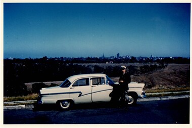
... J. Gur standing beside Ford Customline 'Q' car on Yarra... J. Gur standing beside Ford Customline 'Q' car on Yarra ...J. Gur standing beside Ford Customline 'Q' car on Yarra Boulevard. Circa 1960police vehicles; wireless patrol; motor transport branch; motor transport section; ford customline car; gurr, harold john -
 Kew Historical Society Inc
Archive (Sub-series) - Subject File, Depression, 1930s, 1958
... yarra boulevard... yarra boulevard Archive file containing a anonymous, undated ...Various partiesReference, Research, InformationSecondary Values (KHS Imposed Order)Subject file containing a anonymous, undated article (single page) on the Great Depression in Kew. It might be from Vaughan’s history (1960). It covers Council support and the creation of the Yarra Boulevardgreat depression -- kew (vic.), kew -- history -- 1930s, yarra boulevardgreat depression -- kew (vic.), kew -- history -- 1930s, yarra boulevard -
 University of Melbourne, Burnley Campus Archives
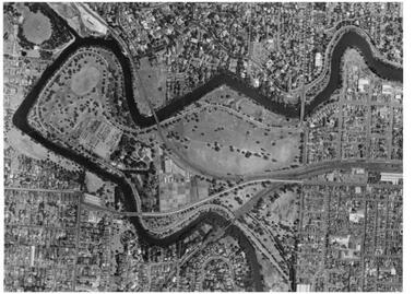
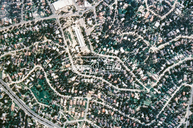
Photograph - Black and white prints, Aerial View of Burnley Campus, 1963-1970
... yarra boulevard... swan street yarra boulevard richmond golf course poultry sheds ...Freeway was not begun until 1968.Black and white photographs. Aerial View of Burnley Campus. (B) Original of (A). Enlargement (C) Laminated copy(A) Inscribed on reverse, "South Eastern Freeway 9.7.63 R22.024.439." (C) Paper attachment: The Burnley College Portion of Richmond Park in 1972. Swan Street Takes Its Familiar Route. The Boulevard Has Been Constructed. The Golf Course is in Place. The Series of Parallel Buildings Along the Railway Line at the Bottom of the Photo Are the Poultry Sheds Used For Egg-Laying Competitions. Burnley Sidings Were Still to be Built. In the Mid-1990's Much of the Western Portion of the College Grounds/Richmond Park Was Sold.burnley campus, aerial view, south eastern freeway, richmond park, swan street, yarra boulevard, richmond golf course, poultry sheds -
 University of Melbourne, Burnley Campus Archives
Album - 35mm Colour slides, BHC Historical, 1950-1972
... yarra boulevard... apiary students wattle garden views yarra boulevard Miscellaneous ...Miscellaneous slides labelled "BHC Historical". Some individually labelled. 1, 2 and 5. of a display "trees to serve the community". "VPRI" (Victorian Plant Research Institute). 10 and 11. of "Wilson's Prom" 1950's. 12. "Apiary" 13. "Students Planting Wattle" beside the Yarra Oct 72. 17. "Native Park Area" 1960's. 14. Garden view.burnley horticultural college, trees, community, vpri, victorian plant research institute, wilsons promontory, apiary, students, wattle, garden views, yarra boulevard -
 University of Melbourne, Burnley Campus Archives
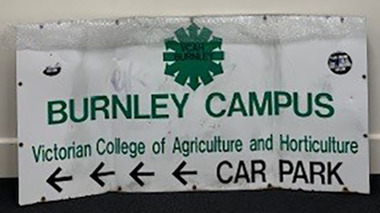
Sign - Campus Sign, Victorian College of Agriculture and Horticulture, Burnley Campus Victorian College of Agriculture and Horticulture Car Park, 1983-1996
... Formerly Attached to fence on Yarra Boulevard sometime 1983...Formerly Attached to fence on Yarra Boulevard sometime 1983 ...Formerly Attached to fence on Yarra Boulevard sometime 1983-1996Large painted metal sign with attachment screws on reverse. Arrows indicate where the Car Park is. VCAH Logo. Sticker attached: Victorian Aids Council Phone Aidsline Aids is Real Use Condoms 419-3166. Another similar sticker on other side partially torn off.BURNLEY CAMPUS VICTORIAN COLLEGE OF OF AGRICULTURE AND HORTICULTURE CARPARKcar park, vcah, aids, victorian aids council, campus signs -
 University of Melbourne, Burnley Campus Archives
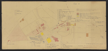
Plan - Coloured plan, Thomas H. Kneen, School of Horticulture - Burnley, 1948-1949
... structures at the College. Plan A: area bounded by Swan St., Yarra...., Yarra Boulevard, reserves for grazing, orchard and vegetable ...Colour-coded to show existing and proposed buildings, numbered and lettered to indicate use of buildings Related documents: B91.476, B91.484Plan with handwritten amendments by T.H. Kneen on 24.10.1949. Extensive explanation of existing and proposed structures at the College. Plan A: area bounded by Swan St., Yarra Boulevard, reserves for grazing, orchard and vegetable gardens along southern boundary. Amended 24/10/49 T.H. Kneent.h. kneen, burnley gardens, burnley school of horticulture, farm buildings -
 University of Melbourne, Burnley Campus Archives
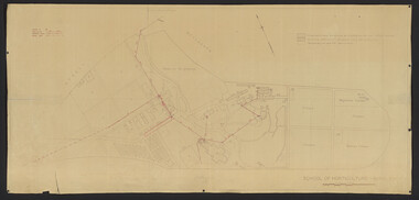
Plan, School of Horticulture -Burnley, 1950
... bounded by Swan St., Yarra Boulevard, orchard, vegetable garden.... Area bounded by Swan St., Yarra Boulevard, orchard, vegetable ...Same layout as plan at B91.0471, but showing PMG cables, and buildings existing, proposed and temporary or for demolitionPlan showing layout of PMG cables and PMG plant. Area bounded by Swan St., Yarra Boulevard, orchard, vegetable garden, market garden and S.W. Boundary to Stockman's Cottage. PMG layout handwritten. On same plan as B91.0484 (original) and B11.0383.burnley school of horticulture, orchard, gardens, vegetables, stockman's cottage -
 University of Melbourne, Burnley Campus Archives
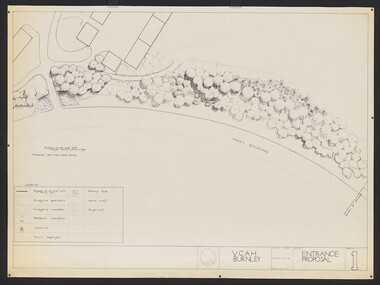
Plan, Entrance Proposal, 1987-1988
... Plans for Entrance from Yarra Boulevard. (1) Tracing paper... from Yarra Boulevard. (1) Tracing paper and paper copies ...Plans for Entrance from Yarra Boulevard. (1) Tracing paper and paper copies, Entrance Proposal Drawing No. 1. V.C.A.H. Burnley, Aug '87 by R.C., Planting Plan. (2) Tracing paper and paper copies V.C.A.H. Burnley 28.9.88 by JK.vcah, burnley, main entrance, jill kellow -
 Ballarat Heritage Services
Photograph, Studley Park Boat House
... Studley Park Boathouse Yarra River boulevard Studley Park ...studley park boathouse, yarra river, boulevard -
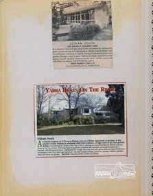 Eltham District Historical Society Inc
Newsclipping, 24 Antoinette Boulevard, Eltham South and Yarra Braes on the river
... 24 Antoinette Boulevard, Eltham South and Yarra Braes on... Boulevard Yarra Braes Newspaper clippings advertising house auctions ...Contained in Volume 1 of a set of two spiral magnetic photo albums, each containing 10 leaves, 20 pages; Vol. 1 labelled "Houses - Eltham South" and Vol. 2 labelled "Eltham Houses". Newspaper clippings advertising house auctionseltham, eltham south, real estate advertisement, houses, antoinette boulevard, yarra braes -
 Ballarat Heritage Services
Photograph, Kew Boulevard, 2025
... Kew Boulevard Yarra River Dight's Falls Photographs ...Photographs of and from Kew Boulevard.kew boulevard, yarra river, dight's falls -
University of Melbourne, Burnley Campus Archives
Plan, A. Lucy, Burnley Gardens Site Works, 1958
... and the Yarra Boulevard. Buildings shown include Fernery, Silo... and the Yarra Boulevard. Buildings shown include Fernery, Silo ...Plan showing layout of Gardens bound by Swan St and the Yarra Boulevard. Buildings shown include Fernery, Silo, Residence, Glasshouses, Manure Bins, Store, Milking Sheds, Admin. Building, Laying Sheds, Breeder Shed, Chicken Run, Potting Shed and Plant Research Lab. Also showing proposed paths and kerbing. Public Works Dept., Chief Engineer's Dept. drawn by A. Lucy. Scale 1 in:40 ftgardens, sheds, glasshouses, buildings, a. lucy -
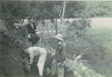 University of Melbourne, Burnley Campus Archives
Photograph - Black and white print, The Truth on How the Swan Street Rockery Was Built, 1947
... and the Yarra Boulevard - this is inside the Burnley property. The work... Swan Street and the Yarra Boulevard - this is inside ...Note by T.H. Kneen 17 June 1992, "The location of this project is the slope between the main entry from Swan Street and the Yarra Boulevard - this is inside the Burnley property. The work was conceived by Arnold Teese & carried out by C.R.T.S. students-visible are Shirley Pittard, Ted Hawkesworth (standing), Dave Hughan (white overalls),Arnold Teese (45-51) supervising."Black and white photograph. Laminated copy. Students and Staff member working on the rock terrace near the Swan Street entranceOn reverse, "The truth on how the Swan Street rockery was built. 1947 Arnold Teese, Dave Hughan, Arnold Teese was a student and then a staff member, 1945-57, David Hughan was a student."arnold teese, david hughan, j.w. newell, t.h. kneen, shirley pittard, ted hawkesworth, crts, rockery, group students and staff, commonwealth reconstruction training scheme, terrace -
 Kew Historical Society Inc
Map, MMBW, MMBW Plan No.39 Kew & Heidelberg, 1900-1910
... Asylum, in the west by the River Yarra [and the later added Yarra... [and the later added Yarra Boulevard] , by Princess Street in the East ...The Melbourne and Metropolitan Board of Works (MMBW) was established by an act of the Victorian Parliament in 1890 to prepare for and to implement a sewerage and water reticulation system across what was then inner Melbourne, its surrounding and middle distance suburbs, including Kew. The MMBW was disbanded in 1991.The map collection of the Kew Historical Society has at its core the historic maps assembled and originally stored in the City Engineer's Department of the City of Kew. These include maps in a number of scales. The vast majority of maps were produced by the MMBW in the first two decades of the twentieth century, and are solid working maps, backed by linen for durability. These maps are historically significant to Kew, the City of Boroondara and to the history of the development of state utilities in Victoria. A number of the Kew maps have additional details added by former municipal officers, including the levels reached by various floods. As these were working documents, information was added to them long after the period of their initial production and distribution.Early map of part of the Borough of Kew, created in the first decade of the twentieth century, at a scale 160 ft to 1 inch. The map covers what was then the north western section of Kew, bordered on its north by Wills Street and the Kew Lunatic Asylum, in the west by the River Yarra [and the later added Yarra Boulevard] , by Princess Street in the East and Holroyd Street in the south. The map shows the extent of urban development by that time, prominent institutions and the outlines of built structures in the municipality. Contour lines were added in ink to the map at a later stage.MELBOURNE AND METROPOLITAN BOARD OF WORKS / PLAN NO. 39 / KEW & HEIDELBERGmelbourne & metropolitan board of works, mmbw maps, mmbw plans, borough of kew, cartography -
 Kew Historical Society Inc
Photograph - Yarra Street, Kew, Ron Setford, 1960
... of the Yarra Boulevard Heritage Precinct.... of the Yarra Boulevard Heritage Precinct. Photograph Yarra Street, Kew ...Ron Setford and his wife Grace Setford lived in Tanner Avenue, East Kew, from c.1946 to c.1995. A keen photographer, he recorded the changing face of Kew over a 20 year period. Apart from 30 photographs of built structures and places in Kew dating from 1960 and 1961, 145 of his 35mm colour slides chronicle the development of the Eastern Freeway through the Yarra Valley over a five year period from c.1972 to c.1977. This important collection was donated to the Society by his granddaughter in 2025.This collection of 175 35mm slides is of local and statewide significance, owing to its subject matter, particularly the major development of road transport infrastructure during the 1970s with the construction of the Eastern Freeway. The photographer also took care to annotate and date most of his slides which enable the researcher to pinpoint temporal and spatial locations.Yarra Street was not made a trafficable thoroughfare until October 1956. Until then, the gully was used as a dump, a shortcut to the river, and for communal Guy Fawkes night bonfires. The open landscape in the photo reflects near-total clearing by the original estate owners for grazing livestock. Post-war homes fronting Stawell St dot the landscape. Of particular note are the Broons House (c.1952–54) by Anatol Kagan (top right), and the homes of two architects, Kurt Elsner (c.1950) (middle) and Geoffrey Danne (c.1954) (lower right). Dual carriageways made blocks accessible, but building was difficult due to steeply sloping land and complex drainage easements. Nevertheless, these challenges resulted in highly innovative designs, making Yarra Street the core of the Yarra Boulevard Heritage Precinct."Yarra St Kew"ron setford, photographs -- kew (vic.) -- 1960s, yarra street -- kew (vic.) -
 Kew Historical Society Inc
Plan - Subdivision Plan, Riversdale Estate, 1939
... College and the River Yarra and The Boulevard.... Station, Scotch College and the River Yarra and The Boulevard ...The Kew Historical Society collection includes almost 100 subdivision plans pertaining to suburbs of the City of Melbourne. Most of these are of Kew, Kew East or Studley Park, although a smaller number are plans of Camberwell, Deepdene, Balwyn and Hawthorn. It is believed that the majority of the plans were gifted to the Society by persons connected with the real estate firm - J. R. Mathers and McMillan, 136 Cotham Road, Kew. The Plans in the collection are rarely in pristine form, being working plans on which the agent would write notes and record lots sold and the prices of these. The subdivision plans are historically significant examples of the growth of urban Melbourne from the beginning of the 20th Century up until the 1980s. A number of the plans are double-sided and often include a photograph on the reverse. A number of the latter are by noted photographers such as J.E. Barnes.The Riversdale Estate in Hawthorn created a subdivision of 20 allotments bordering on Riversdale Road and Riversdale Court (which was created by the subdivision). The Locality Plan at right lists the major public buildings in the area: Burnely Horticultural Gardens, Hawthorn Tram Depot and Railway Station, Scotch College and the River Yarra and The Boulevard.subdivision plans - hawthorn, riversdale estate -
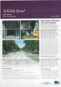 Melbourne Tram Museum
Pamphlet, Yarra Trams, "St Kilda Road - Arts Centre Tram Improvements", April 2008
... and Southbank Boulevard. Has Yarra Trams and State Government logos... a revised junction for South Melbourne Trams and Southbank Boulevard ...Pamphlet - 3 fold A4 pamphlet, full colour, titled "St Kilda Road - Arts Centre Tram Improvements" detailing the construction schedule and photos of the Superstops and additional tracks outside the Arts Centre in St Kilda Road. Shows a track layout including a revised junction for South Melbourne Trams and Southbank Boulevard. Has Yarra Trams and State Government logos. Dated 24/4/2008.trams, tramways, st kilda rd, arts centre, road works, superstops -
 University of Melbourne, Burnley Campus Archives
Album - Colour slides, Burnley Views, 1956-1969
... ." looking towards Dairy and Yarra Boulevard (37) "Pond No. 1717...." looking towards Dairy and Yarra Boulevard (37) "Pond No. 1717 ...Contributor: T.H. KneenBox of 47 slides, some labelled. (1) "Marjorie Hall 1st Year Student June '56 No. 1872." Working with fruit tree stock. (2) "Orchard June 1956 No. 1710." 2 men and a tractor.(3) "Camp 1957." Wilson's Promontory. (4) View of Drive No. 1677." C. 1958 (5) "GenView No. 1771." (6) "Burnley Gardens Entrance 4.4.58 N0. 1672." (7) "Wilson's Promontory Lilly Pilly Gully Nov 1960." (8) Dec '62." (9) "Dec '62." Kneen child. (10) Luffmann Ponds "Aut. 1962." (11) Grevillea Sep 1963. (12) Sep 1963.Reflection of Crack Willow in Luffmann Ponds. (13) Sep 1963. Orchard blossom. (14) View of Administration Building at sunset Aug 1964. (15) Rose 'Heat Wave.' May 1965. (16) Kneen child sitting under a tree May 1966. (17) 'Department of Agriculture Burnley Gardens' sign May 1966. (18) Administration Building May 1966. (19) Plant Science Block May 1966. ((20) Wintersweet August 1966.(Actually appears to be Witch Hazel Hamamelis mollis.) (21) Student on tractor in the Orchard October 1966. (22) Garden view, view of Principal's Residence through blossom trees October 1966. (23) Students walking through the Gardens October 1966. (24) "Leaf Cuttings Rex begonia 2 October 1966. (25) Emily Gibson beds October 1966. (26) Principal's Residence in a garden view October 1966. (27) Garden view looking towards the Principal's Residence and the Shady Garden October 1966. (28) Drive looking towards the Administration Building from the Plant Research Institute. (29) Kneen child (not Burnley?) (30) Unveiling of Burnley Horticultural College plaque commemorating 75 years, 1891-1966 - Eric Littlejohn, ?, T.H. Kneen. Includes key to Pavilion 1969. (31) "Rose Pruning Demo - Canteen." July 1969. (32, 33) "Rose Pruning Demo 1969." July 1969. (34) "Plant Science Block & College." July 1969. (35) Plant Science Block 6/69." July 1969. (36) "Burnley Gardens 6/69." looking towards Dairy and Yarra Boulevard (37) "Pond No. 1717." (38) "Pond 1748." Kneen children playing by the Luffmann Ponds, Oak tree behind.. (39) Ginkgo leaves June 1967. (42) ? (43) Erithyna caffra in flower (removed 2016) December 1966. ((44) Administration Building and Nursery from PRI." (45) Pelargoniums. (46) Azalea mollis (47) Pelargonium foreground, geranium background.marjorie hall, students, fruit trees, orchard, tractor, wilson's promontory, burnley gardens, entrance, drive, garden view, luffmann ponds, grevillea, rose, kneen family, sign, wintersweet, plant science block, administration building, students working outside, principals residence, plaque, rose pruning demonstrations, ginkgo, pelargoniums, erythryna -
 Eltham District Historical Society Inc
Photograph, Fay Bridge, Eastern boundary of former Warrandyte Aboriginal Reserve, North Warrandyte, 7 November 2016
... of the Yarra. This project was initiated by Nillumbik Reconciliation... of the Yarra. This project was initiated by Nillumbik Reconciliation ...Two bronze commemorative plaques on rocks, unveiled by Wurundjeri Tribe Council Elders, mark two eastern boundaries of the former Warrandyte Aboriginal Reserve on the north and south sides of the Yarra. This project was initiated by Nillumbik Reconciliation Group in close association with Reconciliation Manningham and the Wurundjeri Tribe Council, as a means of commemorating the last great corroboree of the Kulin Nation which was held at Pound Bend in March 1852. This plaque is on the Nillumbuk side of the Yarra, accessed via The Boulevard, North Warrandyte. The plaque is set on a rock approximately 50 metres before the turning circle at the end of The Boulevard. Plaque : Warrandyte Aboriginal Reserve This commemorative rock marks an eastern boundary of the former Warrandyte Aboriginal Reserve established in 1852. Centred on Pound Bend, it covered 1,908 acres on both sides of the Yarra River (Birrarung). That same year saw the last great gathering of the Kulin nation here in Wurundjeri country which was celebrated over two weeks with traditional performance and games. For a few years longer the reserve intermittently served as a ration station.With gold having been discovered at Warrandyte, the Wurundjeri were moved on again but ultimately secured a permanent home at Coranderrk, Healesville. A second commemorative plaque and rock is located on the opposite bank of the Yarra and its confluence with Stony Creek. Melway ref : 23 C 9 Unveiled by Wurundjeri Elder, Uncle Bill Nicholson on 23rd March 2013 Funded by the Robert Bridgford Indigenous Trust (Nillumbik Community Fund) with assistance from Manningham City Council Small Grants Program Ref: Monument Autralia https://monumentaustralia.org.au/themes/culture/indigenous/display/99680-warrandyte-aboriginal-reserve-fay bridge collection, 2016-11-07, aboriginal reserve, north warrandyte, plaques, warrandyte aboriginal reserve -
 Eltham District Historical Society Inc
Photograph, Fay Bridge, Yarra River near the eastern boundary of former Warrandyte Aboriginal Reserve, North Warrandyte, 11 August 2023
Accessed via The Boulevard, North Warrandytefay bridge collection, aboriginal reserve, north warrandyte, warrandyte aboriginal reserve, 2023-08-11 -
 Eltham District Historical Society Inc
Photograph, W 27, Mitchell Avenue (Reserve next to Montmorency South Primary), 1966c
Grand Boulevard on right. Looking at what is now Panorama Heights preschoolBlack and white photographic printOriginally located in a Filmpro King Size Prints processing envelope $3.01 Shire of Eltham 9/9/66 and noted as Calrossie Ave area and crossed out Eltham-Yarra Glen Road, Bridge Street to Elsa Court existing conditions mid 1967grand boulevard, mitchell avenue, montmorency, panorama heights pre-school -
 Eltham District Historical Society Inc
Slide - Photograph, Aerial Photo (c.1987): Montmorency South Primary School, Grand Boulevard and Main Road, c.Aug. 1990
Part of a presentation, "Roads and Byways of the Shire of Eltham", by Russell Yeoman to the 12 September 1990 Society meeting. Slides shown included copies of old photos and recent images ranging from the suburban streets of Eltham and Montmorency to the mountain roads of Kinglake. In the byways category are views of some iof the Shire's bicycle paths including then recently completed sections of the Main Yarra Trail at Lower Plenty.35mm colour positive transparency (1 of 37) Mount - Agfachrome Agfa CS System black 8 dotsinfrastructure, roads, aerial photographs, main road, montmorency, montmorency south primary school, grand boulevard -
 Eltham District Historical Society Inc
Slide - Photograph, Grand Boulevard, Montmorency, c.Aug. 1990
Part of a presentation, "Roads and Byways of the Shire of Eltham", by Russell Yeoman to the 12 September 1990 Society meeting. Slides shown included copies of old photos and recent images ranging from the suburban streets of Eltham and Montmorency to the mountain roads of Kinglake. In the byways category are views of some iof the Shire's bicycle paths including then recently completed sections of the Main Yarra Trail at Lower Plenty.35mm colour positive transparency (1 of 37) Mount - Agfachrome Agfa CS System black 8 dotsinfrastructure, roads, grand boulevard, montmorency -
 Eltham District Historical Society Inc
Photograph, Construction of the new concrete bridge over the Diamond Creek on Main Road, Eltham, c.May 1926
Construction of the new concrete bridge over the Diamond Creek on Main Road, Eltham, c.May 1926. Viewed from northern approach looking east, the access drive running off Antoinette Boulevard parallel to Main Road is visible as well as the power lines that used to run in front of Eltham Park (Eltham Lower Park). Also visible is a tree situated beside the roadway. It is believed this is the same tree that remains today as a dead tree trunk immediately adjacent to the road verge armco near the corner of Antoinette Boulevard. The original long suspension bridge over the Diamond Creek on Main Road at Eltham collapsed during flooding of the Diamond Creek on October 13 and 14, 1923. The original bridge was built around 1840 for the coach road when Cobb & Co.'s coach was the only conveyance between Eltham and Melbourne. Widespread damage was done in Melbourne and surrounding areas by floods resulting from the overflow of the Yarra at many points along its banks. A temporary bridge rigged up was severely damaged by the flooding of the creek and was closed to vehicular traffic in April 1924. A new concrete bridge was constructed to replace it and by May 1926 all the concrete piles and abutments had been completed. The bridge was finally completed and opened for traffic in September 1926, almost three years after it initially collapsed.This photo forms part of a collection of photographs gathered by the Shire of Eltham for their centenary project book,"Pioneers and Painters: 100 years of the Shire of Eltham" by Alan Marshall (1971). The collection of over 500 images is held in partnership between Eltham District Historical Society and Yarra Plenty Regional Library (Eltham Library) and is now formally known as the 'The Shire of Eltham Pioneers Photograph Collection.' It is significant in being the first community sourced collection representing the places and people of the Shire's first one hundred years.Photo print 9 x 12.5 cmshire of eltham pioneers photograph collection, eltham, bridge, diamond creek (creek), eltham south, main road bridge, wingrove park, antoinette boulevard, significant tree, cement mixer, bridge construction -
 Eltham District Historical Society Inc
Photograph, 1934 Floods at Eltham
Published in the Diamond Creek Basin Study, 1980 and identified at Diamond Creek, locality not identified, 1934. The location is actually looking south across the Diamond Creek towards Falkiner Street, beside the Main Road bridge at Eltham South from what is now part of Wingrove Park opposite Antoinette Boulevard. The bridge railing is just visible to the left of image. The large leaning Manna Gum beside the bridge still stands in 2021 alongside the Diamond Creek trail. In 1934 extensive flooding of the Yarra River and Diamond Creek set new records for flood plain level (Eltham Chronology, EDHS)Black and white photographCopied by Hugh Fisher, Photographer, 6 York Street Eltham A1678B Floods- Eltham - 1934floods, yarra river, eltham, flooding, diamond creek, flood -
 Eltham District Historical Society Inc
Negative - Photograph, Bridge on Main Road, Eltham, c.1890
Possibly produced as a postcard. Caption in lower right hand corner reads: Bridge (at) Main Road Eltham. The long wooden suspension bridge over the Diamond Creek on Main Road at Eltham collapsed during flooding of the Diamond Creek on October 13 and 14, 1923. The original bridge was built around 1840 for the coach road when Cobb & Co.'s coach was the only conveyance between Eltham and Melbourne. Widespread damage was done in Melbourne and surrounding areas by floods resulting from the overflow of the Yarra at many points along its banks. A temporary bridge rigged up was severely damaged by the flooding of the creek and was closed to vehicular traffic in April 1924. A new concrete bridge was constructed to replace it and by May 1926 all the concrete piles and abutments had been completed. The bridge was finally completed and opened for traffic in September 1926, almost three years after it initially collapsed. Viewed from Antoinette Boulevard looking northwest towards Falkiner Street. The building in the distance believed to be Souters Cottage. On the far right on the very edge of the road verge are two Eucalypt trees, one of which is believed to be the large dead trunk still standing in present day.This photo forms part of a collection of photographs gathered by the Shire of Eltham for their centenary project book,"Pioneers and Painters: 100 years of the Shire of Eltham" by Alan Marshall (1971). The collection of over 500 images is held in partnership between Eltham District Historical Society and Yarra Plenty Regional Library (Eltham Library) and is now formally known as the 'The Shire of Eltham Pioneers Photograph Collection.' It is significant in being the first community sourced collection representing the places and people of the Shire's first one hundred years.Digital image 4 x 5 inch B&W Neg Black and white print 35mm positive transparencyshire of eltham pioneers photograph collection, eltham, main road bridge, eltham south, bridge, diamond creek (creek), significant tree, souters cottage, eltham lower park, main road, sepp -
 Eltham District Historical Society Inc
Photograph - Photograph postcard, The Rose Stereograph Company, View at Eltham, Vic. Postcard sent from Ernest and family to Joe, 3 May 1936, c.1920
Postcard sent from Ernest and family to Joe, 3 May 1936. Original photo estimated to be circa 1920. Looking west across the original Main Road Bridge and the Diamond Creek from near the intersection of Antoinette Boulevard. To the right of the bridge appear to be orchard trees in flood waters. The long wooden suspension bridge over the Diamond Creek on Main Road at Eltham collapsed during flooding of the Diamond Creek on October 13 and 14, 1923. The original bridge was built around 1840 for the coach road when Cobb & Co.'s coach was the only conveyance between Eltham and Melbourne. Widespread damage was done in Melbourne and surrounding areas by floods resulting from the overflow of the Yarra at many points along its banks. A temporary bridge rigged up was severely damaged by the flooding of the creek and was closed to vehicular traffic in April 1924. A new concrete bridge was constructed to replace it and by May 1926 all the concrete piles and abutments had been completed. The bridge was finally completed and opened for traffic in September 1926, almost three years after it initially collapsed. The Rose Series P. 4346 Postcards scanned from the collection of Michael Aitken on loan to EDHS, 13 Feb 2018Digital file only Postcards scanned from the collection of Michael Aitken on loan to EDHS, 13 Feb 2018michael aitken collection, postcards, main road bridge, main road, eltham, antoinette boulevard, diamond creek (creek), eltham south -
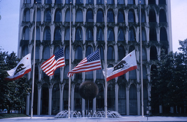 Robin Boyd Foundation
Slide, Robin Boyd, 1965
Robin Boyd was invited to be a judge on the AIA-Sunset Western Home Awards Program (see correspondence item D416). Robin and Patricia Boyd travelled to California in July 1965. They also visited Japan.Colour slide in a mount. Pacific Mercantile Bank Building (or the Perpetual Savings and Loan building), 9720 Wilshire Boulevard, Beverly Hills, Los Angeles, California, USA, 1961(Architect: Edward Durell Stone.)Made in Australia / 15 / Encircled 5 (Handwritten)slide, robin boyd -
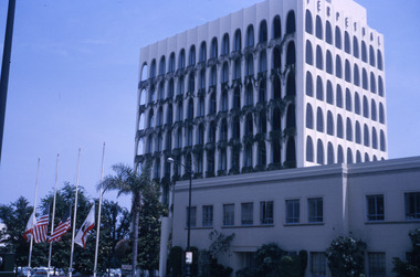 Robin Boyd Foundation
Slide, Robin Boyd, 1965
Robin Boyd was invited to be a judge on the AIA-Sunset Western Home Awards Program (see correspondence item D416). Robin and Patricia Boyd travelled to California in July 1965. They also visited Japan.Colour slide in a mount. Pacific Mercantile Bank Building (or the Perpetual Savings and Loan building), 9720 Wilshire Boulevard, Beverly Hills, Los Angeles, California, USA, 1961. (Architect: Edward Durell Stone.)Made in Australia / 14 / JUL 65M / Encircled 3 (Handwritten)california, slide, robin boyd -
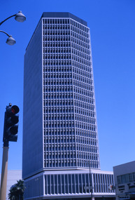 Robin Boyd Foundation
Slide, Robin Boyd, 1965
Robin Boyd was invited to be a judge on the AIA-Sunset Western Home Awards Program (see correspondence item D416). Robin and Patricia Boyd travelled to California in July 1965. They also visited Japan.Colour slide in a mount. California Federal Savings & Loan Building, 5670 Wilshire Boulevard, Los Angeles, California, USAMade in Australia / 26 / JUL 65Mcalifornia, slide, robin boyd