Showing 11585 items matching " maps"
-
 Melbourne Tram Museum
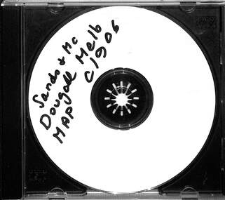
Map - CD - Sands McDougal Map Melbourne c1906, Sands McDougall
Detailed scan of the Sands McDougal Map in colour showing Melbourne's cable trams, railways, Essendon Tramways, NMETL and the Victorian Railways line to Brighton from St Kilda. Includes the MTOCo horse tram lines and the Caulfield horse tram lines. See Reg item 6572 for the actual map. Yields information about Melbourne and its tramways in 1906CD in a plastic case - black with clear cover.CD marked "Sands & McDougal Map c1906"cable trams, tramways, map, sands mcdougal, nmetl, vr trams, horse trams -
 Bendigo Military Museum
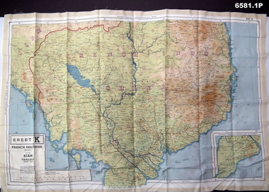
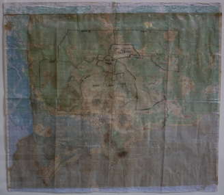
Photograph - Photograph of a silk map of Indo China, Circa 1939
Silk maps were produced as "Escape Maps" as they were easily folded and compressed to carry. They were often sewn into the jackets of aircraft pilots..1P Photograph of a Silk map of Indo China Map No 44K covering Siam (Thailand) and part of Vietnam and Cambodia at a scale of 1:1million. The map has contours (heights) and legend panel information. .2P Photograph of the reverse side of a Silk map of Indo China Map No 44J covering Siam (Thailand) at a scale of 1:1million. The map has contours (heights) and legend panel information. royal australian survey corps, rasvy, fortuna, army survey regiment, army svy regt -
 Creswick Campus Historical Collection - University of Melbourne
Map, 1980
Arboretum plant census locality mapsMap -
 National Vietnam Veterans Museum (NVVM)
Map, Long Tan Original Battle Map
Original topographical map of Long Tan area showing operational marking in black pen. Areas 1-4 marked 5RAR section.This map is the original map from 1 ATF HQ on the day of the Battle of Long Tan, 18th August, 1966.battle of long tan, map -
 Ballarat Tramway Museum
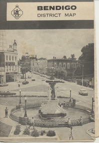
Map, Royal Automobile Club of Victoria, "Bendigo District Map - RACV", c1971
Printed street map titled "Bendigo District Map", published by the RACV, showing the central part of Bendigo, Bendigo Outlets, streets, principal attractions, Bendigo and district maps and information, and a list of sporting and entertainment facilities. Has the tram lines shown dotted, only shows the full extent of the Golden Square line. The main map has the number "0171" in the bottom left hand corner, indicating the publication date.in ink on the Bendigo Outlet map, "3/4" along bottom edge.trams, tramways, map, bendigo, racv, railways -
 Whitehorse Historical Society Inc.
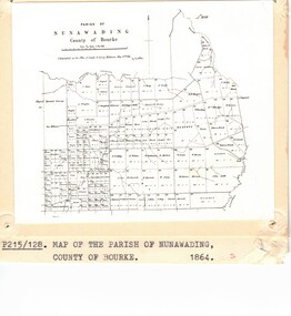
Photograph - Parish Map, Parish of Nunawading
... Maps ...Black and white photo of map of the Parish of Nunawading, County of Bourke, 1864. Copy also at ND880, Map Drawer.parish of nunawading, county of bourke, maps -
 Running Rabbits Military Museum operated by the Upwey Belgrave RSL Sub Branch
Map
... Maps ...Topographic map of Nui Datmaps, vietnam, army -
 Victorian Aboriginal Corporation for Languages
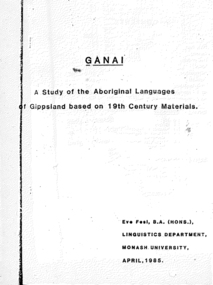
Thesis, Eve Fesl, Ganai : a study of the Aboriginal languages of Gippsland based on 19th century materials, 1985
Honours thesis in linguistics (unpublished) at Monash University. Detailed studies of Gippsland languages (Ganai) including maps, extensive discussion of historical sources, and a fairly detailed grammatical study of Ganai. Includes wordlists organised by areas of meaning.Maps, word listsganai, gippsland -
 Tatura Irrigation & Wartime Camps Museum
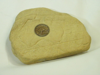
Carving, sandstone, 1940
Item carved by a German Internee who was held in Camp 1 in WW2. Came into the possession of one of the guards, whose nephew donated it to Tatura MuseumSandstone piece with carved map of Austraiia, Tatura 1939-1940, and a 1939 penny inserted in the stone."Tatura Vic.1939-40." Map of Australia/Bird.internment camp 1, tatura, german internee.. -
 Bendigo Military Museum
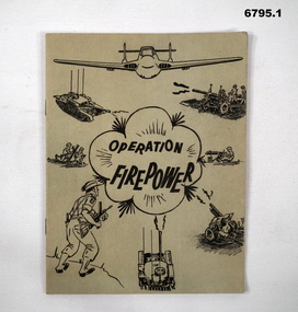
Manual - TRAINING MANUALS VARIOUS, 1937, 1959
1. An instruction manual outlining the structure of a military exercise to practice Battle activity at a Brigade level. 2. An instruction manual outlining the proper way to read a map and the logic of it's structure. 3. Illustrative guide on what leaders should expect in relation to their soldiers. Items in the collection re Col J Swatton, refer Cat No 6719.2P for his service details.1. Green cover, 16 page booklet titled " Operation Firepower" . Dated March 1959, which planned an army exercise at Brigade Level. Outlined aim, Tactical setting, maps and plans. 2. Loose stapled 28 page manual on reading maps. Yellow paper with three folder holes punched in left size. Contains instructions and pictures and examples. 3. Brown covered manual, yellow faded pages, 60 pages inside with pictorial content displaying the do's and don't's of the behaviour of a good soldier.1. Maps have some notations, images of vehicles/weapons on front. 2. Titled " Map Reading - Supplement A.T.M. (AUST) No 12". Written on top " Colonel J.W. Swatton". 3. Titled "Right or Wrong": Element of Training and Leadership illustrated 1937". Stamp on back saying "on loan" but now donated.passchendaele barracks trust, training manuals -
Glenelg Shire Council Cultural Collection
Souvenir - Cloth Badge - Nelson Endeavour River Cruise, n.d
Cloth badge, oval, Nelson Endeavour River Cruise; light blue map of Australia, red arrow identifying Nelson; red ship's wheel either side, dark blue lettering, white background; white embroidered border on badge; white backing.Front: 'Nelson Endeavour' - above map "River Cruise' - below mapsouvenir, nelson river cruise -
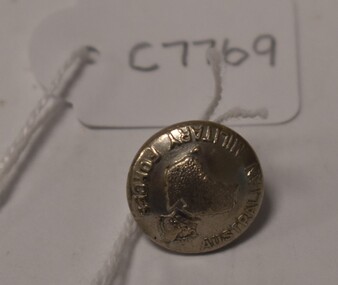
 Tatura Irrigation & Wartime Camps Museum
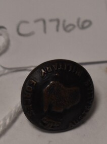
Button
Issued to Sister Kathleen Heaphy of Australian Army Nursing service. Sister Heaphy was attached, for part of her service, to 28 Camp Hospital Internment camp 1.round brass button with a metal shank. Crown and map of Australia and wording around the circumference. A split pin is through the shanks.Australian Military Forces A crown and map of Australia australian army nursing service, sister kathleen heaphy, 28 camp hospital internment camp 1 -
 Federation University Historical Collection
Map, Ballarat, Victoria, 1942, 1942
Two copies of a map of the district around Ballarat, including Creswick, Scarsdale, Smythesdale, Lake Bolac, Ararat, Talbot, Sebastopol, Maryborough, Cardigan, Skipton, Mount Emu Creek, Leigh River, Fiery Creek, Hopkins River. Street names are listed on the back of the map. It includes roads, timber, creeks, rivers, telephone lines, railwayPrinted in red at the base of the map "This map is an official document. If found, itmust be handed in to the nearest Military Headquarters or Police Station.ballarat, map, world war two, skipton, creswick, ararat, lake bolac -
 Marysville & District Historical Society
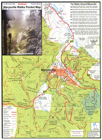
Map (Item) - Pocket map, Rooftop Mapping Services, Rooftop's Marysville Walks Pocket Map, 01-2009
A pocket map of ten walking tracks in an around Marysville. This map was published by Rooftop Mapping Services in January 2009.A pocket map of ten walking tracks in an around Marysville.marysville, victoria, australia, rooftop mapping services, steavenson falls, steavenson falls car park walk, beauty spot walk, marysville to el kanah guest house walk, gilberts gully walk, michaeldene track, man 'o' war walk, tree fern gully walk, marysville to woods lookout to mount gordon walk, keppels lookout walk -
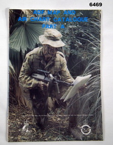 Bendigo Military Museum
Document - ADF Map and Air Chart Catalogue Part A, RASvy Corps, May 1991
This document contains the "map and Air Chart Demand and Issue Voucher" to enable the ordering of map products. The catalogue of available products is shown on the reverse side to assist in the ordering process.1. A Map sheet of Australia folded to A4 in size. 2. A selection of map examples and a catalogue of products, Tactical Line Maps (TLM) at 1:50,000 scale to Digital Chart of the World (DCW) at 1:1,000,000 scale maps. The names of all the 1:100,000 maps are listed in alphabetical order. 3. The Map and Air Chart Demand and Issue Voucher is printed on the back of the document. 4. Front section has a photo of a soldier with a Steyr rifle kneeling reading a map.royal australian survey corps, rasvy, fortuna, army survey regiment, army svy regt, asr -
 Flagstaff Hill Maritime Museum and Village
Parallel Rule, Early 20th Century
John Bliss (1795-1857) was born in Norwich Connecticut, trained as a silversmith and clockmaker in Vermont, and began in business as a jeweller in New York around 1830. In 1834, now trading as Bliss & Creighton, he made and marketed a range of nautical instruments. The business subsequently became John Bliss & Son in 1855 and John Bliss & Co. in 1857. It remained in business until 1957 when it was acquired by West Marine. The Bliss company used to make a range of instruments supplied to a variety of customers including the US Navy. An object made as an aid for marine navigation, to plot a course on a nautical map for a vessel to follow. The item was made by a well known American maker of nautical instruments and is significant in regards to it's provenience and history of the maker and his family who over the years had been innovators and makers of various types of nautical instruments since 1795. Parallel map ruler. Bliss of New York & Nautical instruments engraved on face of ruler, ruler divided into degrees for use on nautical mapsflagstaff hill, warrnambool, shipwrecked-coast, flagstaff-hill, flagstaff-hill-maritime-museum, maritime-museum, shipwreck-coast, flagstaff-hill-maritime-village, parallel rule, map reading, nautical object, navigation instrument -
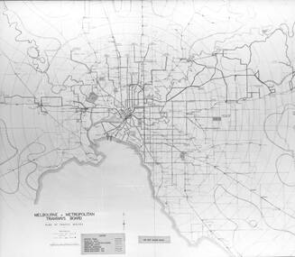 Melbourne Tram Museum
Photograph - Black & White Photograph/s of MMTB Map, Melbourne & Metropolitan Tramways Board (MMTB), 1975
... Maps ...Black and White Photograph of the MMTB tram and bus services c1975. The tram line to East Burwood is not shown. Possibly used in a report 1975 as it shows the urban development in 1945 and 1975.On the rear of the photograph has in pencil "Route Map - MMTB".trams, tramways, maps, buses, mmtb -
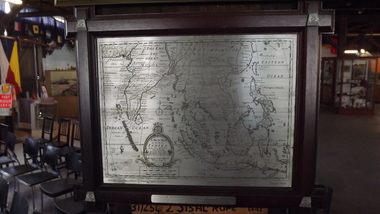 Seaworks Maritime Museum
Selangor Pewtor map of East Indies, Possibly Malaysia, 1993
Selangor Pewter Map of East Indies. Original map was created in 1700s and this reproduced pewter map was based upon originals in the Collection of Muzium Negara, Malaysia. The map is framed in a dark wood frame with pewter flowers decorating each corner. The incisions are far darker than other pewter map.On the verso: PMA0298 Royal Selangar (on frame) Text located on map: ‘A NEW MAP OF THE EAST INDIES…’ ‘Reproduced from the collection of Muzium Negara, Malaysia. Selangar Pewter.’ On plaque: ‘IN COMMEMORATION OF/ THE MAIDEN VOYAGE OF EUROPEAN EXPRESS TO MELBOURNE/16th Sep 1993’ Sticker at top of frame stating ‘MISC.’gifts -
Beechworth RSL Sub-Branch
Map confidential
Map covering the area south of Saigon shows the following AO's Duc Thanh, Debonah, Sadue, Xuyen Moc &Nui Nhon, Janette, Vung Tau special Zone and small arm ChristineExplanation of basic map reading south of saigon -
Whitehorse Historical Society Inc.
Map, Sands and McDougall's Map of Melbourne & Suburbs, 1950s
... Maps ...Wall map of Melbourne and suburbs 12-18 mile radius of CBD.Wall map of Melbourne and suburbs 12-18 mile radius of CBD.Wall map of Melbourne and suburbs 12-18 mile radius of CBD.melbourne, maps -
Creswick Campus Historical Collection - University of Melbourne
Document, Forests Commission Victoria, A list of rare, very localised and endangered indigenous plants of Victoria, c.1982
1 Booklet and 29 maps in boxed set.Maps and Booklet -
 Kiewa Valley Historical Society
Maps - Kiewa Valley Parish Maps x3 and Kiewa Area Planimetric Map x1
Planimetric maps are 2 dimensional representations of the Earth's surface, showing the location and spatial arrangement of features such as roads, buildings, and bodies of water. The parish maps show the occupiers with leases or licences of the land. These are updated by the Department of Lands regularly. The names of early settlers of the Kiewa Valley occupying land by lease or licence are shown. Many of these familie's descendants still live in the Kiewa Valley.1. Kiewa Area Planimetric Map (photo) 2. Wermatong, County of Bogong Parish Map 3. Mulllindolingong, County of Bogong Parish Map 4. Mullagong, County of Bogong Parish Map All black and white kiewa valley. parish maps. land owners -
 Otway Districts Historical Society
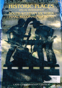
Book, Land Conservation Council, Historic places: special investigation: South-Western Victoria: Final recommendations, January 1997
The Land Conservation Council has carried out an investigation of historic places in public land in South-western Victoria. The report contains the Council's recommendations for the protection, management and future use of more than 700 historic places, out of 2200 places identified during the investigation. The places have been assigned to three categories, A, B and C, representing State, regional and local levels of significance. The report also contains recommendations relating to general historic places management, the processes available in Victoria for the protection of historic places on public land, and Aboriginal historic places.Historic places: Special investigation: South-Western Victoria: Final recommendations. Land Conservation Council. Land Conservation Council; Melbourne (Vic); January 1997. viii, 176 p.; illus.; maps. Soft cover. ISBN 0 7241 9290 5Maps in plastic sleeve.land conservation council; conservation; historic places; public land; aborigines; south west victoria; -
 Otway Districts Historical Society
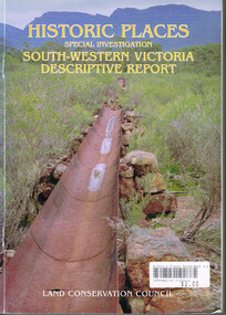
Book, Land Conservation Council, Historic places: Special investigation: South-Western Victoria: Descriptive report, January 1996
The south-west of Victoria, possessing a rich heritage of the signs of past human activity, is fertile ground for an investigation of historic places on public land. This report includes an initial inventory of almost 2000 places. The report outlines the history and the related heritage of the area, describes in some detail its biophysical attributes and introduces the natural resources and present land use. This information provides a context for understanding the origins of the historical features that are observes today.Historic places: Special investigation: South-Western Victoria: Descriptive report. Land Conservation Council. Land Conservation Council; Melbourne (Vic); January 1966. viii, 180 p.; illus.; maps. Soft cover. ISBN 0 7241 9288 3Maps in plastic sleeve.land conservation council; conservation; south-western victoria; historic places; -
 Federation University Historical Collection
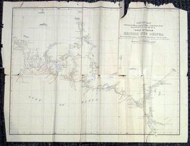
Map, British New Guinea, 1893, 1893
The map was surveyed by ship compass, distances by estimation or rate of launch by officers of the Government ; supervised and compiled by J.B. Cameron, G.S. March 1893. This map was in the possession of Charles Carty Salmon (1860-1917), politician, born on 27 July 1860 at Amherst, Victoria. (http://adb.anu.edu.au/biography/salmon-charles-carty-8328 ) Although living in Melbourne Charles Carty Salmon kept property at Talbot. The property was leased, then purchased by the donor's family. A copy of "The Goulburn Weir and its Dependent System of Works" and this map (in a government envelope addressed to Salmon) were left at the property. See http://nla.gov.au/nla.map-rm1894-1 .1) Sketch map showing the rivers and an outline of the coast from Long. 144?30'E. to Long. 146?30'E. Gulf of Papua British New Guinea Scale [ca. 1:316,800]. .2) Large envelope addressed to The Hon Charles Carty Salmon M.P., Talbot, Victoria. The map was folded and stored in this envelope. Map extending from Port Bevan to Kaikavau Pt, showing rivers and notes on soil and vegetation. Relief shown by hachures and spot heights. Also available in an electronic version via the Internet at: http://nla.gov.au/nla.map-rm1894-1 .1) "Enclosure in Despatch No. 32 of 3rd May 1893 - Appendix G.". "Map no. 4 British New Guinea report 1892-93". .2) "This envelope can only be lawfully used by Government Officials on public business. Any use by Officials on private business, or by others under any circumstances, is punishable." "Commonwealth Celebrations. General Secretary's Office, Melbourne."carty salmon, charles carty salmon, new guinea, j.b. cameron -
Beechworth Honey Archive
Map- Eldorado
Compiled from 1971 aerial photography. Printed in 1978.Map shows Eldorado town, Reedy Creek, abandoned gold dredge and Monument Hill. Scale 1:25,000. Printed colour on paper.Map labelled Eldorado. No. 8225-3-4map, eldorado, reedy creek, dredge, monument hill, aerial photography, paper, beechworth honey -
 Bendigo Military Museum
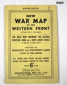
Map - WAR MAP WESTERN FRONT, Geographer's Map Co Ltd, c.WWII
Folded map fixed into yellow cardboard folder with black printing. Map covers battle areas late in WWII of Maginot Line & Siegfried Line from Metz, France to Karlsruhe, Germany.On cover in black print: “Second Edition. New War Map of the Western Front”map, seigfreid, maginot -
 Tatura Irrigation & Wartime Camps Museum
Button, Stokes and Son
Issued to Sister Kathleen Heaphy of Australian Army Nursing service. Sister Heaphy was attached, for part of her service, to 28 Camp Hospital Internment camp 1.round silver metal button with a metal shank. Crown and map of Australia and wording around the circumference. Australian Military Forces A crown and map of Australia Stokes and Sonsaustralian army nursing service, sister kathleen heaphy, 28 camp hospital internment camp 1, brass buttons -
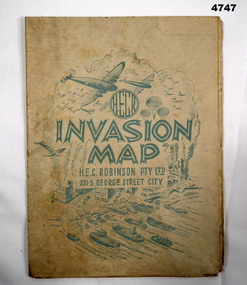 Bendigo Military Museum
Map - INVASION MAP, H.E.C Robinson PTY LTD, Post 1945
... Maps ...Map, Robinsons Invasion Map of part of Europe rectangular shape, countries in seperate colours and boundaries in red, when folded has a front piece in blue showing planes, parachutes, boats and Cities, rear of the fold has a list of maps by Robinsonsmaps, invasion europe, robinsons -
 Warrnambool and District Historical Society Inc.
Map, Department of Lands and Survey (Lithographers), Caramut township, 1938
This map of the township of Caramut was produced in 1938 but shows the original land owners of each town allotment and of the surrounding area. The size of all the allotments and the date of the original purchase are also shown. Caramut is a Victorian Western District town on Mustons Creek on the Hamilton Highway 48 kilometres from Warrnambool. This map was used by Rolf Crawley when he was the engineer for the Shire of Warrnambool from 1935 to 1968. The annotations on the map have probably been made by Rolf Crawley as they refer to the records and letter books of his father, John William Crawley, Junior (Shire of Warrnambool Engineer 1895 to 1935). Both Rolf Crawley and his father, John had private businesses as architects, surveyors and engineers and the map could have been used in connection with both their official Shire duties and their private businesses. The last owner of the map was the surveyor, Michael Hand who took over the business of Rolf Crawley in the late 1960s. This map is of great interest firstly because it has all the historical details of the land first purchased in the town of Caramut and area and secondly because it came from the office of Rolf Crawley, the engineer for the Shire of Warrnambool from 1935 to 1968. This is a buff-coloured paper map with a cloth backing. The map details are in black and white print. There are some handwritten red and black annotations on the map. “Town of Caramut Parish of Caramut County of Villiers’town of caramut, john william crawley junior, warrnambool, rolf crawley, warrnambool