Showing 1368 items matching " dandenong rd"
-
 Glen Eira Historical Society
Document - Hotels, Caulfield
This file contains one item: 1/Handwritten research notes recording details about various hotels in the Caulfield area and environs. Details include handwritten maps and lists of publicans/licensees/nominees. Notes by author unknown and undated. Some of the notes make reference to entries in Sands & McDougall directories.r. k. cole hotel collection, london tavern hotel, london tavern and store, glen huntly road, caulfield, sycamore street, hawthorn road, dandenong road, derby road, koornang road, caulfield club hotel, rosstown hotel, royal hotel, the vine beer house, the vine caulfield hotel, newton h., balaclava road, bambra road, mirrambeena road, murrumbeena road, poath road, the tam o’shanter hotel, wilston street, farmers’ arms home hotel, chestnut street, hooper street, thompson william, martin p. j., orme frederick, orme fred, nicholls william henry, mullins john, armstrong john, egan james, westwood james, westwood ellen, greenberg david, greenberg sydney, greenberg rose, spamm cath, pitter mabel, morrow andrew, morrow andy, feddan george curtis, guess john, evans rowland, evans roland, riordan john, smith george elms, bedwell c., griffen frederick, connelly p. h., uhrbrock f., swift charles, gregor f., hazlett david, moore l., harley susan, mott h., nichols william henry, ross peter mclean, elsternwick, mcnamara margaret, mcnamara v., stevens catherine, mcgregor f., clarice george -
Glen Eira Historical Society
Document - LAND SUBDIVISIONS 1880-1938
This file contains various subdivisions’ advertising flyers and cards. 1/Advertising announcement for auction sale of land (15 lots) at Glenhuntly Tram Terminus, to be held on 29/03/1924. Verso is map of the area (21.5cm x 29cm) 2/Advertising announcement for Trustees’ Auction sale of corner shop sites at Caulfield South near Glenhuntly Road and Hawthorn Roads, 15/11/1927 (21cm x 31cm) 3/Advertising pamphlet (A3) for auction of Cantala Estate, East St. Kilda (32 allotments), between Dandenong, Waiora, and Alma Roads, 21/05/1938 (15.5cm x 28.5cm) 4/Seven advertising postcards relating to auctions of land in Caulfield and Elsternwick. Only one (10 December 1881) with a year on it. (Each 13.5cm x 9cm) 5/Four more advertising postcards relating to auctions of land in Caulfield. One is dated 31/11/1880(?); another 09/02/1905. A third has no date. A fourth postcard is a map of allotments between Orrong, Kooyong, Seymour and Alison Roads, Caulfield, no date (each 13.5cm x 9cm) 6/Large advertising poster (41cm x 52.5cm) for ‘Carnegie Land Sale’ auction of the Egan Estate (near Carnegie Railway Station) on 12 April, no year given, but appears to be circa1900 7/‘Riddell Estate – Plan of Subdivision – Parish of Prahran’ mounted map, no date, probably c. 1900 (16cm x 21cm)auctions, house auctions, land subdivision, land development, subdivisions, caulfield, land subdivisions, east st. kilda, glenhuntly, carnegie, map, ‘new glenhuntly tram terminus estate’, ‘cantala estate’, ‘strathnaver estate’, ‘range estate’, ‘egan estate’, ‘riddell estate’ -
Glen Eira Historical Society
Article - Olympic Games 2000
This file contains one item relating to the torch relay of the 2000 Olympic Games: 1/A newspaper article from the Glen Eira News, Vol. 44, September 2000, describing the events of a leg of the Olympic torch relay that went down Hawthorn Road, between Dandenong Road and North Road. The article includes 6 colour photographs taken by Bernie Bickerton and an article written by primary school student Daniel Kontrobarsky describing the event. Author unknown.hawthorn road, north road, dandenong road, olympic games, olympic torch, children, councillors, athletes, aged people, bickerton bernie, gardenvale primary school, kontrobarsky daniel, police, caulfield, caulfield north, caulfield south, glen eira, irwin chris, brown damien, stacey jay, cordingley louise, bentleigh east, glen eira town hall, primary schools, camden community, rosstown community, torres ron, local officials and employees -
Glen Eira Historical Society
Ephemera - Restaurants-Glen Eira
This file contains one item: 1/A pamphlet for Mandarin Court Restaurant, 557 Centre Road Bentleigh, and its sister restaurant in Dandenong, both owned by Michael and David Chew. The pamphlet contains the history of Mandarin Court Restaurants, maps of its locations, opening hours, and its takeaway menu. A special offer is included stamped as valid until 15/08/1987.mandarin court restaurant, chew michael, chew david, bentleigh coppins reception, centre road, bentleigh, restaurants -
Glen Eira Historical Society
Article - St Pauls Anglican Church, 530 Dandenong Road, Caulfield North
Two Port Philip Leader articles on the Rev Howard Langmead. His talents as a comedien and acknowledgement of the church’s Billboard sign, which is causing a lot of interest, locally and interstate. Date unknown. Includes two colour photographs.caulfield, billboards, st pauls anglican church, comedians., langmead howard rev., st clements anglican church, dandenong road, brighton road, caulfield north, elsternwick -
Glen Eira Historical Society
Article - Toyne, Gilbert
This file contains two documents. Typewritten letter from Peter Cuffley providing background on Gilbert Toyne, manufacturer of the QUICK-DRY Rotary Clothes Hoist in Dandenong Road. Envelope attached. Computer print-out on HUNG OUT TO DRY the book, written by Peter Cuffley. Interview with him on ABC Ballarat Radio. Small black and white photo of hoist.toyne gilbert, quick dry rotary clothes hoist, toyne trading co., farrier, vernegie, ellimatta road, morton road, caulfield racecourse -
Glen Eira Historical Society
Pamphlet - Air raid precautions
This file contains two items about air raid instructions during World War 2. 1. Air Raid instructions booklet (15 pages), National Emergency Services of NSW’s official public handbook , produced by Consolidated Press Ltd. 2. City of Caulfield Air Raid Precautions (1 page), cardboard instructions approved by State Emergency Council for Civil Defence, Victoria.world war 1939-1945, emergency services, air raid precautions, air raid sirens, air raid shelters, air raid wardens, caulfield, hawthorn road, packer j. i., tyers s. w. cr., dandenong road, carnegie, briggs james. r. town clerk -
 Glen Eira Historical Society
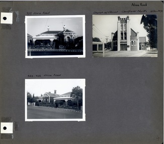
Album - Album page, Alma Road, circa 1972
... 198 pages. Church of Christ, 514 Dandenong Rd, Caulfield https ...This photograph is part of the Caulfield Historical Album 1972. This album was created in approximately 1972 as part of a project by the Caulfield Historical Society to assist in identifying buildings worthy of preservation. The album is related to a Survey the Caulfield Historical Society developed in collaboration with the National Trust of Australia (Victoria) and Caulfield City Council to identify historic buildings within the City of Caulfield that warranted the protection of a National Trust Classification. Principal photographer thought to be Trevor Hart, member of Caulfield Historical Society. Most photographs were taken between 1966-1972 with a small number of photographs being older and from unknown sources. All photographs are black and white except where stated, with 386 photographs over 198 pages. Church of Christ, 514 Dandenong Rd, Caulfield https://vhd.heritagecouncil.vic.gov.au/places/43594 The Dandenong Road Church of Christ has regional importance as a landmark building along the Dandenong Road. It successfully addresses its triangular site by placing the belltower at the apex, deploying Romanesque and Gothic elements freely and to dramatic effect, heightened by the symbolism of the Cross (compare Robert Haddon's St Stephens in Balaclava Road of 1926).Page 4 of Photograph Album including three black and white photographs of properties on Alma Road. Two photographs are in the top half of the page and the third is in the bottom left hand side.Handwritten in black pen: Alma Road [top right of page] / 325 Alma Road [above top left photograph] / Church of Christ Caulfield North 14 Dec 1972 [above top right photograph] / 323-325 Alma Road [above bottom left photograph] / 4 [bottom right]caulfield north, trevor hart, alma road, houses, churches, church of christ caulfield north, dandenong road, bell towers, romanesque architectural style, gothic architectural style, bi-chromatic brickwork, cast iron work, verandahs, victorian architectural style -
Glen Eira Historical Society
Document - St Giles Presbyterian Church, Murrumbeena
One item about the history of this Church for later period: Two copies of the booklet ST GILES 1890 TO 1990, ONE HUNDRED YEARS IN MURRUMBEENA, dated 15/07/1990 by St Giles Publicity Committee, includes photographs.st giles presbyterian church, murrumbeena presbyterian church, murrumbeena methodist church, ministers, sunday schools, uniting church, armstrong w. j., armstrong w. j. mrs., secomb w. e. rev., andrews mr., crabtree mr., hocking mr., hocking mrs., dandenong road, belgrave road, murrumbeena, harwood c., oakleigh carnegie circuit, sunday schools, murrumbeena methodist men’s movement, hartley f. rev., orton j. russell rev., manzoney w. s. rev., shotton h. t. rev., eldridge l. b. rev., wilcock s. c. rev., bye r. rev., slattery k. rev., archbold b. rev., sunderland h. rev., blanksby a., mcdonald n., porritt d., lukies j., reid g., orton a., reid g., orton a., reid pris, reid will, pollock lex rev., pollock mabel, evans derek rev., mclean colin rev., denholm robin rev., mcrae dick, elmore frank rev., tara grove, brown robert rev., murrumbeena, murrumbeena road, church groups -
Glen Eira Historical Society
Article - Caulfield Institute of Technology
Two items from newspaper cuttings relating to this Institute: 1/Article from Chadstone Progress 19/03/1980 on parking problems. The local council suggested public transport instead. Titled 'Parking Problem at CIT' in 2 columns. School of Community and Access Education at C.I.T. stated in an article from the Caulfield Contact 26/03/1981 that they were running classes for older adults on local history of Caulfield and seeking interested participants. Titled 'Reflections of Life in Caulfield' in one column.c.i.t., caulfield institute of technology, logan brian, benn anthony, booth laura, dandenong road, caulfield east, caulfield, students, education, parking, country roads board, education department, victorian amateur turf club, student union, school of community and access education, education program for older adults, history, technical colleges, caulfield council, tertiary education, road construction and maintenance, caulfield racetrack, caulfield racecourse -
Glen Eira Historical Society
Article - Ross, William Murray
This file contains one item: 1/The obituary of William Murray Ross from Brighton Southern Cross, dated 03/09/1904. Ross is commemorated as a pioneer of Caulfield, and the obituary includes a biography recording his life in the area.murray ross william, ross william murray, obituaries, caulfield, pioneers, ‘the grange’, jordan sergeant, sugar beet, sugar industry, rosstown refinery, rosstown railway, railway lines , elsternwick railway, dandenong road, hawthorn road, inkerman road, local government, caulfield road board, pennington harold councillor, kooyong road, glen eira road, watts thomas, v.a.t.c. racecourse, street names, aboriginal languages, caulfield council, lempriere councillor , death and dying, bayston councillor, mayors, brighton southern cross, rosstown, funerals -
 Cockatoo History & Heritage Group
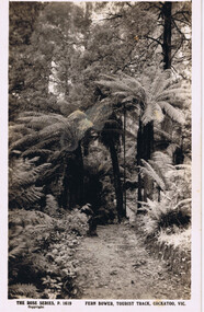
Postcard, Rose Stereograph Co, Fern Bower, Tourist Track, Cockatoo, VIC
Cockatoo's Tourist Track featured in many postcards that were produced. It was an important attraction for the many holiday makers that came to Cockatoo in the early part of last century.The Tourist Track extended along the Cockatoo Creek, crossing the creek in various parts. It seemingly followed the creek until it ended in the vicinity of Mountain Rd and started near the swimming pool.Original Postcard - The Rose Series P 1619 cockatoo creek, tourist track, rose series postcard, cockatoo victoria -
 Camp Eureka Working Collective
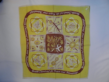
scarf
The scarf was worn by Eileen Capocchi, a member of the Eureka Youth League Choir who sang at the Youth Carnival for Peace and Friendship and donated the item. The planned event had been targeted by Prime Minister Menzies as a Communist Party activity. The Commonwealth Government pressured local Sydney Councils to deny the organisers a venue. These attempts failed. The event combined sporting, athletic and musical events at a football stadium. In later years it was the subject of two documentary films. The scarf is of historic and social significance because of its association with the Peace Carnival for Peace and Friendship of 1952 and the Eureka Youth League. The scarves were worn by all participants and by Eureka Youth League members in subsequent years. The scarf records some of the musical and sporting events organised by the Eureka Youth League in most major Australian cities.Brown and yellow square rayon machine edged scarf made for the 1952 Youth Carnival for Peace and Friendship in Sydney. Central portion shows a peace dove, pink heath, flannel flower and wattle. Perimeter shows a saxophonist, ballet dancer, high jumper, hurdler, cyclist and volleyball net. "Youth Carnival for Peace and Friendship" white script on 3cm brown banner repeated 4 times around perimeter.eileen capocchi, eureka youth league choir, youth carnival for peace and friendship, eureka youth league, 1952 -
 Yarra Ranges Regional Museum
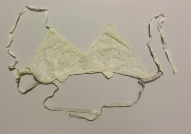
Brassiere
This Brassiere belong to Mrs Zilpah Winifred Carroll (nee Parker) (1914 - 2001) and formed part of her trousseau. Zilpah, known as Win, married Harold Stewart (Bill) Carroll on Dec 21, 1938 at St MAry's Anglican Church on Glen Eira Rd, Caulfield. The Carrolls moved to Belgrave with their children in 1954 and lived there for over 40 years. Zilpah was supposed to be names "Zilpha" after a fictional heroine, however her father misspelled the name on her birth certificate. Cream lace bra with elastic and ribbon shoulder straps, two buttons to stretch and fasten at front. -
 Puffing Billy Railway
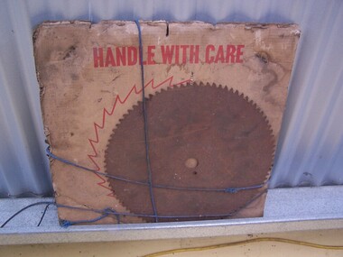
Timber Mill - Packet of Round Saw Blades
Historic - Industrial - Timber Mill Saw BladesHistoric - Industrial - Timber Mill Saw BladesTimber Mill - Packet of Round Saw Blades made of steelHandle with Care A MSS Product 551 771 MI Melbourne Saw Manufacturing Co. PTY 107 Northern Rd West Heidelberg Vic. Ph 45-4133 puffing billy, timber mill saw blades, melbourne saw manufacturing co. -
 Puffing Billy Railway
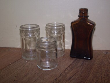
Bottle and Jars found at the Museum in the ground
Bottle and Jars found at the Museum in the ground Bottle with Pecks RD NO 30273 embossed on base - Peck's Fish Paste, circa: early to mid 20th century Historic - Bottle and Jars found at the Museum in the ground Bottle and Jars found at the Museum in the groundBottle and Jars found at the Museum in the ground Bottle with Pecks RD NO 30273 embossed on base - Peck's Fish Paste, circa: early to mid 20th century puffing billy, bottle and jars -
 Dandenong/Cranbourne RSL Sub Branch
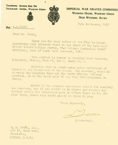
Letter, 24th September 1957
Letter from the Secretary of the Imperial War Graves Commission to Mr G. A. Brown c/o 21 Dora Rd, Wimbledon, London, regarding the location of grave for the late 4443 Driver Albert William Jordan, 21st Brigade Australian Field Artillery, date of death 14th November 1916Letter to Mr Brown from the Imperial War Graves Commission. Letter was typed on a typewriter on letterhead."IMPERIAL WAR GRAVES COMMISION / WOOBURN HOUSE, WOOBURN GREEN / WIGH WYCOMBE, BUCKS" (typed) imperial war graves commission, wwi, wooburn house -
 Mt Dandenong & District Historical Society Inc.
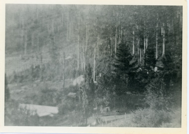
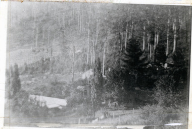
Photograph, View Over Roof of "Kalorama"
Taken in 1908, this photograph, though rather blurry, gives an indication of the location of the early settler properties in the valley in relation to one another. European trees have been planted at 'Kalorama' , the first home of Ellis Jeeves. John Lundy-Clarke grew up in the Kalorama/Mt Dandenong area and later in life (1972-74) began to write a comprehensive history of the area working from an original settlement map in an effort to cover all areas.Black and white photograph looking across hillside with large trees and rooftops visible. Handwritten description on reverse by John Lundy-Clarke.1908 View over roof of “Kalorama” towards the Falls. Paynter’s house on LOT 29 in low centre (now “Yosemite”). Pimms house on LOT 19 above Paynters and beyond scrub. Logan’s house faint above left of “Kalorama”. Dunbar’s LOT 20 beyond Pimm’s orchard. Gum trees on right were on Price’s LOT 19 now Tosari Rd area. It was one of these that figured in the episode of the runaway log in 1930. It leaped in one bound over Barbers Road at bottom of scrub in centre of picture then over Logan’s house.kalorama, ellis jeeves, jeeves -
 Mt Dandenong & District Historical Society Inc.
Photograph, Walker's LOT 2
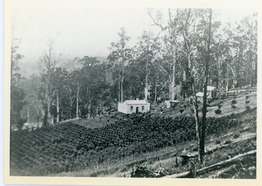
Lot 2 was bought by Harry Walker in the early 1900s. Harry was married to Eva Hand, one of the six daughters of Thomas and Eliza Hand. Harry cleared the land and planted half with raspberries that remained productive until c1928. Harry's son William took over the property. The land was cut in half when the new CRB road went through in the early 1920s. John Lundy-Clarke grew up in the Kalorama/Mt Dandenong area and later in life (1972-74) began to write a comprehensive history of the area working from an original settlement map in an effort to cover all areas.Black and white photograph showing a single storey white house in the centre surrounded by crops. Handwritten description on reverse by John Lundy-Clarke.VIEW 1908 OVER LOT 2 SECTION 1 VILLAGE SETTLEMENT. TAKEN FROM RIDGE ROAD THEN MAIN ROAD FROM HALFWAY BETWEEN MOUNTJOY AND FALLS RD. CRB MAIN RD RUNS BEHIND WALKER’S HOUSE. The house seen in the vista among the tall trees beyond the raspberry patch is “Forest Edge” which was George Barber’s home when the picture was taken. The tall trees to the right of the vista were on Price’s LOT 18 and it was while cutting up one of these for firewood that a length of log weighing about ½ a ton got away downhill and leaped in one bounce over Barbers Road and Logan’s house – 1931.harry walker, william walker, eva hand, crb road, raspberries, kalorama -
 Mt Dandenong & District Historical Society Inc.
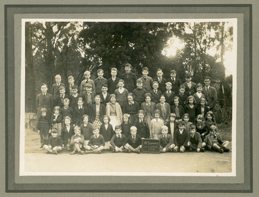
Photograph, Mt Dandenong School 3284 1942, 1942
Formal school photograph of the students at Mt Dandenong State School taken in 1942. Mounted on stiff cardboard.Handwritten on back of photograph: Betty Jeeves (Law Smith) 1st right middle row Stamp G. E. Hains Photographer 654 CANTERBURY Rd. SURREY HILLS, E10mt dandenong school, betty jeeves, elizabeth law smith -
 Mt Dandenong & District Historical Society Inc.
Photograph, Harmony Vale, c1913
View of Harmony Vale, the original Kalorama settlement taken from Barbers Road. Child's sawmill can be seen (centre) with the log yard to the right. Richardson's home "Harmony Vale' is in the orchard above the logs.Black and white photograph copied from a Rose Series postcard showing the area known as "Harmony Vale' - the original Kalorama settlement. Child's sawmill is in the centre.Rose Series Photo of Harmony Vale on the Olinda Creek taken from Logans Lot 28. Link Rd crossing centre Shiloah complex left centre. Richardsons (Jeannie’s) “Mt Calvin” between trees above tree fern. Isaac Jeeves house with the tree fern floor among trees against forest right centre. Mill yard with logs above cultivated flat. Mill to left. “Harmony Vale” homestead among orchard above logs. “Glenrivers” in gully at top of clearing. About 1913. Copied JLC 1973harmony vale, harmony vale, child's sawmill, sawmill, barbers road, richardson, shiloah -
 Mt Dandenong & District Historical Society Inc.
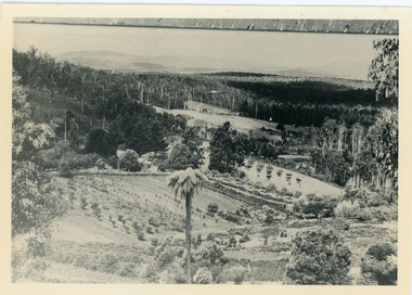
Photograph, View of valley looking south over 'Kalorama' towards falls, 1908
View taken 1908 looking south over 'Kalorama', home of Ellis and Eliza Jeeves, across the valley towards the falls.This photograph has a detailed inscription on the back handwritten by John Lundy-Clarke in 1974.View taken 1908 of valley looking south over “Kalorama” towards the falls. House right of “Kalorama” was Paynter’s “Iona” on Lot 29. Faintly below line of Barber’s Road above “Kalorama” is Logan’s house on Lot 28. House against orchard was Pimm’s later Prince’s Lot 19. Big trees on right were on Price’s Lot 18 and were between Tosari Rd and Rosemont Cres. It was FROM one of these being cut up in 1931 that the round length log weighing ½ a ton got away from the splitters and raced down the hill in bounces, one of which cleared Barber’s Rd and Logan’s house in leaping from the fence line above the road.kalorama, paynter, iona, barbers road, ellis jeeves -
 Mt Dandenong & District Historical Society Inc.
Photograph, Kalorama Gap in 1927, 1927
View of the Kalorama Gap (FiveWays) in 1927. Buildings shown are Jeeves' Garage, FiveWays Cafe, Nicholl's Store, Mountjoy. CRB Main Road, Ridge Road, Old Coach Road and barber's Road also visible. This photograph has a detailed inscription on the back handwritten by John Lundy-Clarke in 1974. The Kalorama Gap in 1927. Showing Jeeves Garage Fiveways Cafe Nicholls Store 'Mountjoy' C.R.B Main Rd Center Ridge Road Right of Center Old Coach Road lower right corner behind shed Barber's Road going left through clump of trees in center kalorama gap, kalorama, fiveways, fiveways cafe, jeeves, jeeves garage, garage, nicholls store, mountjoy, barbers road, old coach road, ridge road, main road, crb road -
 Mt Dandenong & District Historical Society Inc.
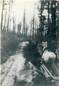
Photograph, View From Seat of Jeeves Coach, c1921
View the driver would have from horse drawn coach. CRB (Main) Road between Wombat Road and Falls Road. c1921. This photograph has a detailed inscription on the back handwritten by John Lundy-Clarke in 1974.View from seat of Jeeves Coach over horses while being driven along the new CRB road between Wombat Road and Falls Rd 1921.wombat road, falls road, crb road, jeeves coach, horse -
 Southern Sherbrooke Historical Society Inc.
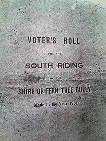
Voters Roll South Riding Shire of Fern Tree Gully 1951, Voter's Roll for the South Riding of the Shire of Fern Tree Gully, 23rd July 1951 (certified)
Voter's roll prepared for Local Government elections, August 1951. Photocopy of original document owned by Mr & Mrs Newstead, Temple Rd, Belgrave South.Photocopy of Voter's roll, South Riding, Shire of Fern Tree Gully 1951, comprising 30 typed pages and printed front cover.election 1951 -
Southern Sherbrooke Historical Society Inc.
Map - photocopy, Woodcock & McCormack, civil engineers & architects & surveyors, The Major Estate, Belgrave
A photocopy taken from the original land sale map provided to the society through Karel Coxell of Stockdale & Leggo. The original maps are stored in large bound account books and were originally the propert of McNally Real Estate. The books are held (in 22 A3 sheets. Shows The Serpentine between Government Rd (now Sandells Rd) and Government Rd(now Terrys Ave), Belgrave. Arrows to Belgrave, Sherbrooke Falls, Main Rd and store.land sales, advertisement, real estate subdivision, t. mahoney -
 Southern Sherbrooke Historical Society Inc.
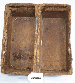
Sandwich Loaf Tin
Used at Eliot's Bakery in Ena Rd around the 1950's, where the Police Station is now located. Was found when Police Station was constructed. Later donated to Southern Sherbrooke Historical Society by Phil Garland.Two rectangular tins joined together, used to bake 2 sandwich loaves at once. Used at Elliot's bakery in Ena Rd, Belgrave.bakrery, belgrave -
 Southern Sherbrooke Historical Society Inc.
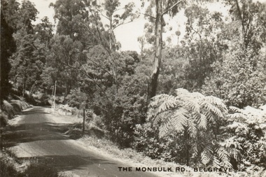
Postcard, The Monbulk Rd, Belgrave
Sepia-toned postcard showing Monbulk Rd, Belgrave, presumably heading towards Kallista. Road is unmade. Trees and ferns growing along side of the road. The ground slopes downhill from left to right. At a bend in the road a stretch of wooden barrier is visible near a gully. -
 Southern Sherbrooke Historical Society Inc.
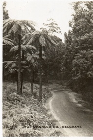
Postcard, The Monbulk Rd, Belgrave
Sepia-toned postcard featuring Monbulk Road, Belgrave, presumably heading towards Kallista. Very tall fern trees on left side of road. Road not made. -
 Southern Sherbrooke Historical Society Inc.
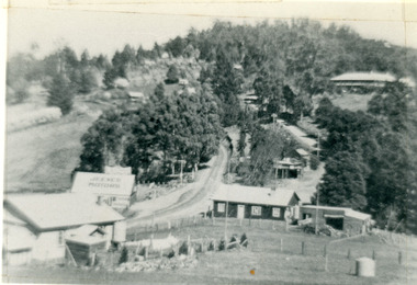
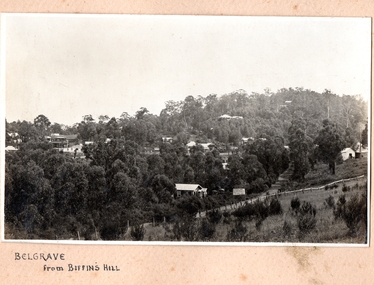
Photograph, Belgrave from Biffin's Hill
Photo of Belgrave township from Biffin's Hill (present-day site of Mater Christi School). Road running across front of photo is now Belgrave-Gembrook Rd. There is a sign on the side of the road advertising Biffin Hill Estate for sale. Belgrave main street is visible in background. c. 1920s