Showing 3432 items
matching distances
-
 Hume City Civic Collection
Photograph, c 1978
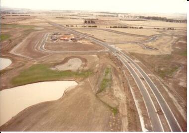
On 4th August 1978 the construction of the Goonawarra Estate commenced. The estate was formerly known as the Goonawarra Farm and overlooked the Sunbury Township and the Jacksons Creek Valley. Plans for the development included a golf course, houses and community and recreational facilities. The golf course opened in 1980 and the housing construction continued throughout the last two decades of the twentieth century and into the twenty first century.A coloured aerial photograph of a display village area under construction. Two lakes are on the LHS of the photograph and Francis Boulevard is in the foreground and the middle distance.goonawarra golf club, goonawarra farm, goonawarra housing estate, housing developments, sharkey, robert b., kilkenny homes, australian ideas homes pty.ltd., glamor homes, craftsmen homes., villa bella homes, george evans collection -
 Stawell Historical Society Inc
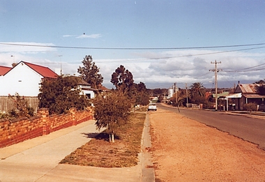
Photograph, Houston Street looking towards Grampians -- Coloured
Large Colour photo of Houston Street looking towards Grampians. Brick fence on left.Coloured Photograph of a street looking toward the grapians whih are covered in clouds. Brick fence ofn left and a white car in the mid distance.stawell houses -
 Mt Dandenong & District Historical Society Inc.
Photograph
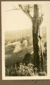
The photograph is from the album of Ivy May Child. It shows a view across the holding of Walter Jeeves. Walter was the second son of Ellis Jeeves and grandson of Isaac Jeeves, the pioneer. Walter was given the house 'Kalorama' and 20 acres of lnd - most of it sloping. He established a commercial garden, initially growing vegetables but later flowers and shrubs. This land now forms part of Kalorama Park. The building in the photograph is the Kalorama Homestead with shrubs and trees planted in rows on the sloping site. Ivy May Child (1910 – 1989) was the daughter of Arthur Edward (Ted) Child (1878 – 1964) and Ethel May Madden (1888 – 1970). Ted Child was the son of Matthew Francis Child (1839 – 1933) and Martha Jeeves (1857 – 1926). He was the grandson of one of the early pioneers Francis Child. Ivy grew up on the family property on Childs Road and took many photographs. Most of these are glued into her photo album. The album covered the years from c1927 – 1932. Ivy married Henry William Burgess (1906 – 1968) in 1944. The photographs remain in their original state in the album with individual copies made. Black and white photograph with a large gum tree in the foreground, a sloping area of cleared, cultivated land and homestead in the centre and a forested area in the distance.An inscription below the photograph in the album reads: W. JEEVESwalter jeeves, jeeves, kalorama homestead, kalorama park -
 Kew Historical Society Inc
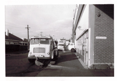
Photograph - The Model Dairy Pty Ltd, 1968
This well-known Kew business, which would become known as The Model Dairy, was founded in 1863 by James Venn Morgan. Morgan sold the company in the 1890s to John Simonton who renamed the business The Model Dairy Co. Simonton had experience in the local dairying industry having previously leased the Willsmere Park Dairy. He moved the business to Belmont Avenue in c.1899. In 1924, following his retirement, the company expanded to become The Model Dairy Pty Ltd with Arnold Thompson Simonton and John Tanner as its owner/directors. With new techniques and processes such a pasteurisation, the Belmont Avenue site no longer met required standards for processing and bottling, so its operations moved to 191 Cotham Road. The company celebrated its centenary in 1963. A new factory, built in 1959 to a design by Bates, Smart & McCutcheon, was purchased by Bib Stillwell Motors after the dairy closed. The entire site has since been redeveloped.Original black and white photographic positive of Model Dairy Trucks in Kent Street, Kew. Barenya Court and Cotham Shopping Centre in distancethe model dairy pty ltd, the model dairy co, john simonton, james venn morgan, john tanner, cotham road, kent street, ridgeway avenue, bates smart & mccutcheon, dairies -- kew (vic.) -
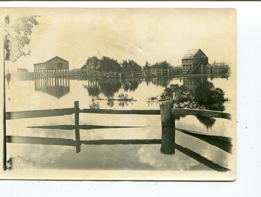
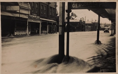 Kew Historical Society Inc
Postcard - Flood, Glenferrie Road, Hawthorn, 1921
An item from an outstanding and diverse photographic and postcard collection, assembled by members of the Christian and Washfold families of Kew.Flood waters in Glenferrie Road. Glenferrie Meat Supply – Boyd & Winnett opposite. Car in distance in flood waters. Real photo postcardglenferrie road -- hawthorn (vic.), floods -- hawthorn (vic.), christian-washfold collection -
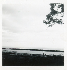
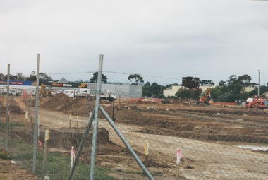 Sunbury Family History and Heritage Society Inc.
Photograph, 13 April 2000
In 2000 work commenced on the further development of railway land on the west side of Sunbury station for the construction of commercial and entertainment facilities. Prior to this time the land had been undeveloped and was often used to accommodate visiting circus troupes. Cereal storage silos also occupied this area for some time. The development of this area has been a reflection of the rapid expansion of settlement within Sunbury and surrounding areas that occurred during the early years of the twentieth century.A coloured photograph of a fenced off area undergoing development with earthmoving equipment and trucks in operation and some commercial buildings visible in the middle distance.sunbury railway station -
 University of Melbourne, Burnley Campus Archives
Photograph - Black and white print, Administration Building, 1949-1951
Black and white photograph. Taken from a long distance across the lawn looking towards the Eastern facade. Early days of garden planting. On reverse, 85 556 and a signature.administration building, garden planting, garden view, main building, emily gibson beds, lily ponds, luffmann ponds -
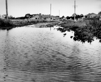 City of Kingston
Photograph - Black and white, c. 1958
This photograph depicts flooding of Ozone Avenue in Beaumaris, located off Balcombe Road. Roads in the Beaumaris area lacked sufficient drains to clear surface water. In many cases streets were unsealed and without footpaths and some were dirt tracks. Gutters and road surfaces were made of clay and in the wetter months of winter, unsealed roads and tracks became impossible quagmires that were unnavigable for vehicles and pedestrians. In the first decade after World War II there was rapid expansion in construction of new houses in the suburb of Beaumaris. Utilities and infrastructure to support the growth of housing was inadequate and not provided for prior to the development of the area. Without rudimentary drainage, flooding was frequent. Storm water runoff, domestic sullage and septic tank overflow would form large pools and families were sometimes marooned within their homes. The frequent flooding caused isolation and hardship and residents endured difficulties with accessibility to facilities. These disadvantages had the potential to cause social issues for the new residents.Black and white photograph of flooding in Ozone Avenue, Beaumaris. The image shows floodwaters with boggy and rough terrain on an unsealed road with housing in the distance.Handwritten in blue ink: 2124 circled Handwritten in red ink: 80% Handwritten in blue ink on yellow Post-It note: Chap 6. underlined, 2194 Ozone Ave Beaumaris 1958beaumaris, ozone avenue, balcombe road, flooding, roads, infrastructure -
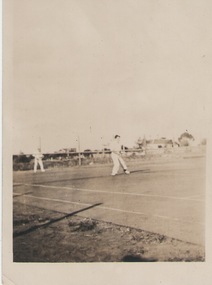 Sunbury Family History and Heritage Society Inc.
Photograph, C 1930s
The men were playing tennis on courts that were sited on railway land behind the post office between Evans Street and the railway line in Sunbury. The house in the background was in Evans Street near the post office.During the nineteenth century in Sunbury, various sporting groups such as tennis, cricket and football, were established in Sunbury.A non-digital sepia photograph with a white border of two men playing tennis. There is a house in the middle distance. The photograph is a Kodak print C592tennis, tennis courts, evans street -
 Lakes Entrance Historical Society
Photograph - Cunninghame Arm, Fraser, Nancy, 1970c
Black and white photograph of a distant view township and Cunninghame Arm and scrub covered hummocks of southern shore in distance. Lakes Entrance Victoria topography, waterways -
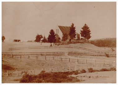 Linton and District Historical Society Inc
Photograph, St Paul's Church of England, Linton
Sepia photograph of a high roofed brick church building surrounded by fence and some trees, seen from a distance with empty paddocks around."Esther Cluff Linton".st paul's church of england -
 Canterbury History Group
Photograph - Street view of the laneway between shop nos 121 and 119 Maling Road, Jan Pigot, 27/03/1993 12:00:00 AM
Coloured photograph of a street view of the laneway between shop nos 121 and 119 Maling Road. The elevated railway can be seen in the distancecanterbury, maling road, shops, laneways, railway stations -
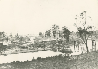 Lakes Entrance Historical Society
Photograph - Mitchell River Bairnsdale Victoria, F Cornell, 1870
Black and white photograph of the punt on the Mitchell River and the first bridge under construction. In distance can be seen the growing township of Bairnsdale Victoriaboats and boating, businesses, rivers -
 Eltham District Historical Society Inc
Photograph, Fred Mitchell, Heading north along Main Road approaching intersection with Mount Pleasant Road, Eltham, 1968, 1968
Wingrove Cottage visible in distance.Digital copy of colour photographfred mitchell collection, 1968, main road, wingrove cottage -
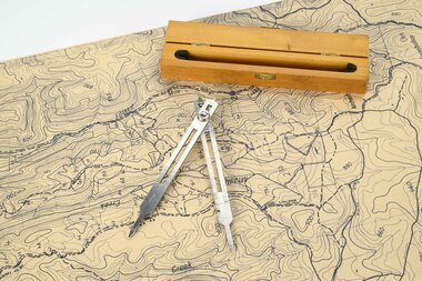 Department of Energy, Environment and Climate Action
Mapping dividers
used to measure distances on mapsAdjustable stainless steel mapping dividers with wooden boxforests commission victoria (fcv), forest measurement, surveying, mapping -
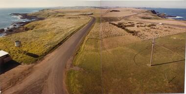 Phillip Island and District Historical Society Inc.
Photograph, John Cook, 1978-79
Photograph a part of the John Cook AlbumView looking east from the new Beacon Tower (1979) back along the Island. Cat Bay in the distance on the left and Bass Straight on the right.the nobbies phillip island, cat bay phillip island, john cook, coloured photograph -
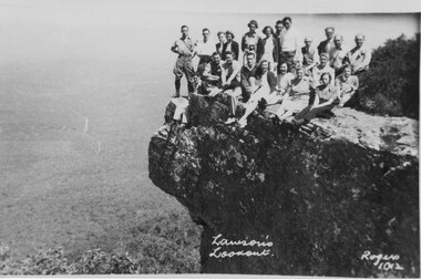 Halls Gap & Grampians Historical Society
Photograph, C 1930s/40s
C 1930's/40's. This is a photo of a group of tourists on Lawson's Lookout, taken by Gilbert Rogers, a well known Hall's Gap photographer.The photo shows a group of twenty-one men and women posed on a rocky outlook. A bushy valley can be seen below with a road winding into the distance."Lawson's Lookout Rogers 1012" inscribed into lower part of photo.scenery, lookouts, people, tourists -
 Orbost & District Historical Society
black and white photographs, 1890s
Peter Cameron, came to Orbost in 1885, at the age of 69, having sold his farm at Geelong. Peter bought the property ―Glen Avon from a Mr Street. The home was situated at the bottom of the paddock, near the corner of Morley and Livingstone streets. The farm stretched from Tennyson Street to the end of Snaggers Lane and along the river frontage to “Carinya” Cameron Home. In the Gippsland Times on Wednesday. 2 Jul 1890 on Page 3 is an article titled "THE SNOWY RIVER CALAMITY" which describes an ".unexpectedly sudden rush of water down the flats..... the terrified people commenced to remove their stock from the land and the work of saving property was continued all day ............ many head of cattle were washed away.......The river road, for its entire length, is obliterated, and the approaches to the bridge at Watt's Gulch are gone, with the enormous volume of flood water," These photographs are pictorial records of a significant event in the history of Orbost. There are few personal records of the very early floods.Three black / white photographs of wooden buildings with flood water in foreground. There are post and rail fences. 3193.2 has been taken from a distance.on back -" "Glenavon east of Lagoon 1897 Feb"floods-orbost-1890s glenavon-orbost -
 Federation University Historical Collection
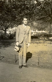
Photograph - Black and White, Frank Wright, circa 1930's
Frank Wright was a renown resident of Smeaton, where he was born. He lived at Laura Villa, and attended Smeaton State School. His father William was a gold miner and his mother's name was Sarah. Their family won many singing and instrumental awards. Frank was tutored by Percy Code and was awarded a gold medal for the highest marks in the ALCM examinations in the British Colonies at the age of seventeen years. He became the Australian Open Cornet Champion by the age of eighteen. A year later, Frank conducted the City of Ballarat Band, and later the Ballarat Soldiers’ Memorial Band. He formed the Frank Wright Frisco Band and Frank Wright and his Coliseum Orchestra. These bands won many South Street awards, and Frank as conductor won many awards in the Australian Band Championship contest. In 1933 Frank Wright sailed to England to conduct the famous St Hilda’s Band and was later appointed Musical Director of the London County Council, where he organized many amazing concerts in parks, in and around the London district. He was made Professor of Brass and Military Band Scoring and conducted at the Guildhall of Music and Drama. Frank was often invited to adjudicate Brass Band Championships around Europe, in Australia, including South Street and in New Zealand. The Frank Wright Medal at the Royal South Street competition is awarded to an individual recognized as making an outstanding contribution to brass music in Australia.Black and white photograph of a man in a light coloured suit, holding a hat and gloves. He is standing on a path within a park, with trees in the middle distance.Printed on back - Veloxfrank wright, cornet, conductor, ballarat, st hilda's band, parkland -
 Federation University Historical Collection
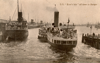
Postcard, S.S. "Erin's Isle" off down to Bangor, 1912
Erin's Isle was a paddle steamer built in 1912 by Messrs. A. & J. Inglis Pointhouse, Glasgow, for the Belfast and County Down Railway Company. It provided a regular service between Belfast Lough and Bangor, County Down in the summer season. In November 1915 it was requisitioned by the Admiralty, initially for transport purposes, and later as an auxiliary mine sweeper. Surviving World War One, this vessel as lost on 7 February 1919 after hitting a stray mine at the entrance of the Thames Estuary and immediately sank. There were 23 lives lost, and 28 survivors. Bangor is a city in Gwynedd Unitary Authority, north west Wales, and one of the smallest cities in Britain. This postcard was sent home to Australia by a six bob a day tourist, and member of the Australian AIF on active service. During leave soldiers often visited tourists sites, family, or towns important to their ancestral heritage.A view of paddle steamer with three moored mail steamers are visible to the left, and a pier and lamp on right. A ship can be seen iin distance on right. S.S Erin's Isle off down to Bangorchatham-holmes family collection, bangor, belfast, mail ships, steam ship, six bob a day tourist -
Bendigo Historical Society Inc.
Painting - EDITH LANSELL OIL PAINTING, 1900
Oil painting on canvas of 8 cattle drinking by the lake with man and dog. Boat on lake. White birds, mountains in distance. Gold embossed frame.E.Lansell ( local identity )artwork, oil painting, cattle by lake -
Port Melbourne Historical & Preservation Society
Photograph - Myk's Mixed Business, cnr Graham and Albert Streets, Port Melbourne, James Lauritz, 1980s
Obtained from the photographer by Pat Grainger during the Vintage Port Worth Preserving project in 1990.Colour laserprint of James Lauritz photograph of Myk's Mixed Business, milkbar at the corner of Graham and Albert Streets in the 1980s/90s; city of Melbourne in distancebusiness and traders - milkbars, james lauritz -
 Victorian Interpretive Projects Inc.
Photograph - Colour, Clare Gervasoni, Mount Franklin From Maldon, 2013, 09/01/2013
Mount Franklin was named after John Franklin.A digital colour photograph showing the extinct volcano known as Mount Franklin in the distance. The photo was taken from the site of the former Beehive Mine in Maldon.mount franklin, maldon, volcano, beehive, beehive mine -
 Buninyong & District Historical Society
Photograph - Original Photograph, Green Hill/Mt. Helen area, Mt. Helen Homestead in distance, 1967
historicColour photograph, Green Hill/Mt. Helen area, Mt. Helen Homestead in distance, in 1967, just prior to developement as tertiary education facility..buninyong, mt. helen, green hill, homestead -
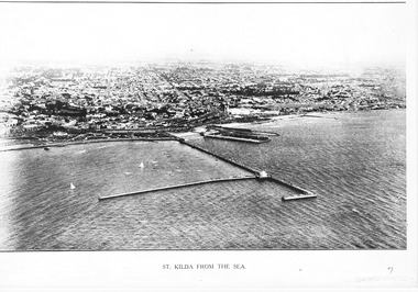 St Kilda Historical Society
Photograph - Photograph Arial
aerial photographPhotograph black and white arial Copy of original. View of water, yachts in foreground and pier with Catani gardenes midground and rest of St kilda in distance.St Kilda from the Sea -
Tatura Irrigation & Wartime Camps Museum
Photograph, Goulburn Waranga Main Channel Construction, 1957
Photo taken by the photographer for Victoria State Rivers and Water Supply Commission of the Goulburn Waranga main channel in 1957.Large black and white photograph - dry mounted to cream board. Channel excavation scene - with excavator operating in mid distance, tractor with rooter in foreground.Below photo: "Goulburn Waranga Main Channel Construction / Channel excavation in progress / 200 W. Bucyrus Dragline, D.8 Caterpillar Tractor with rooter with "Gradall"goulburn, waranga, irrigation, photo, victoria state rivers and water supply commission -
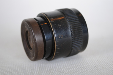 Anglesea and District Historical Society
Magnifyer
Black single magnifying glass (no handle) sometimes called a "loupe". Magnification can be adjusted by turning the small end. Mid distance manifying only.magnifer, loupe, monocular -
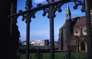 Robin Boyd Foundation
Slide, Robin Boyd
Colour slide in a mount. Melbourne Grammar School. New Science wing (in distance), South Yarra, circa 1964. (Architects: Mockridge Stahle and Mitchell.)Mount Made in England / Encircled 1 (Handwritten)slide, robin boyd -
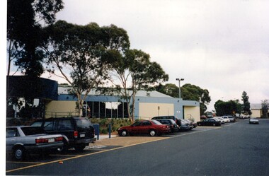 Whitehorse Historical Society Inc.
Photograph, Basketball Stadium, East Burwood
The East Burwood stadium was opened on the 24th July 1970 by Victorian Premier, Dick Hamer. It was the most famous basketball venue in the 70's and 80's costing $8 million. The stadium was financed by basketball patrons under administration of the Nunawading Basketball Association, a non-profit community advancement company. The stadium caters for 7000 players per week.Coloured photograph of the basketball stadium East Burwood. Cars parked at the front. The East Burwood hall in the distance. Located in Burwood Hwy East Burwood.basketball stadium, east burwood, sporting venue -
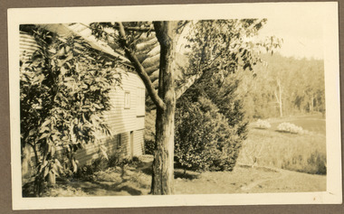 Mt Dandenong & District Historical Society Inc.
Photograph
The photograph is from the album of Ivy Child. The photograph is a side view of the homestead of Ted and Ethel Child. Ted is recorded as having a well established garden. Ivy May Child (1910 – 1989) was the daughter of Arthur Edward (Ted) Child (1878 – 1964) and Ethel May Madden (1888 – 1970). Ted Child was the son of Matthew Francis Child (1839 – 1933) and Martha Jeeves (1857 – 1926). He was the grandson of one of the early pioneers Francis Child. Ivy grew up on the family property on Childs Road and took many photographs. Most of these are glued into her photo album. The album covered the years from c1927 – 1932. Ivy married Henry William Burgess (1906 – 1968) in 1944. The photographs remain in their original state in the album with individual copies made. Sepia photograph with a tree in the centre and a wooden building to the left. Bushes are in front of the building. A cleared area with rows of planted trees is visible with bush in the distance.ivy child, ted child, ethel child, kalorama, homestead, garden