Showing 811 items
matching maps and sections
-
 Melbourne Tram Museum
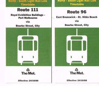
Ephemera - Timetable/s, The Met, "The Met Tram North-South Light Rail Line Timetable", Oct. 1988
Set of 2 The Met Tram timetables, folded sheets, 7 or 10 sections, providing timetables for specific routes, day of week giving information on tram times at specific time points, route map, sections and fares and phone contact numbers. Titled "The Met Tram North-South Light Rail Line Timetable" Issued at the time of the opening of the light rail services along the former St Kilda and Port Melbourne railway lines. .1 - Route 96 - East Brunswick - St Kilda Beach via Bourke St city - 24/10/1988 .2 - Route 111 - Royal Exhibition Buildings - Port Melbourne via Bourke St City - 24/10/1988trams, tramways, the met, timetables, melbourne, fares, light rail, route 96, route 111, conversion, port melbourne, st kilda, east brunswick -
 Melbourne Tram Museum
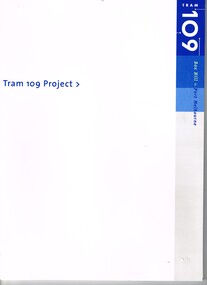
Document - Folder with papers, Yarra Trams, "Tram 109 Project", Apr. 2003
Set of six documents contained within a card board folder marked "Tram 109 Project" issued at the time of the opening of the tramway. .1 - folded cardboard folder, with 109, State Government, Yarra Trams and VicRoads logos. .2 - pamphlet - fold out - 5 x 2 sections with map of the extension, location of tram stop either kerb or Superstops, notes on the extension and method of track construction - two copies held. .3 - foldout - 4 section - pocket map of stops and service frequencies. .4 - media release for the opening of the line - dated 2/5/2003 - two pages stapled in top left hand corner - two copies held. .5 - folded A3 sheet - printed single side - colour competition for the opening of the tramway, closing 28/4/15 and welcoming people to the opening celebrations. .6 - Colour book - 12 pages + card covers titled "The adventures of Tram 109" with the Alstom and Yarra Tram logos, cartoons or illustrations by Warwick Hook.trams, tramways, yarra trams, route 109, box hill, mont albert, superstops, tram stops, opening, colouring book -
 Geoffrey Kaye Museum of Anaesthetic History
Book, Longman, Brown, Green and Longmans, Physical Description of New South Wales and Van Diemen's Land. Accompanied by a geological map, sections, and diagrams, and figures of the organic remains, 1845
... Land. Accompanied by a geological map, sections, and diagrams ...Dr. Gwen Wilson, Emeritus historian, gifted this book at ANZCA's first independent Annual Scientific Meeting held in Launceston in 1994. Dr Wilson presented this gift after her speech about the life of William Russ Pugh and his significant contribution to anaesthesia in Australia. It is unclear as to how the book came into Dr Wilson's possession. Published in London, 1845, for Longman, Brown, Green and Longmans, this book was formally owned by general practitioner Dr William Russ Pugh, being the first medical practitioner in Australia to administer ether anaesthetic on 7 June 1847, in Launceston. The author of the book, P E De Strzelecki acknowledges Pugh for his assistance during his stay in Launceston and for allowing him the use of his laboratory for the analysis of the soils and minerals that were subsequently reported in this book (Page 131). Tan coloured cloth book with an embossed circular motif on the centre of the front and back cover. The same embossed motif is repeated four times along the spine of the book. An embossed design of small, four petal flowers borders the edge of the front and back cover. The title of the book 'Strzelecki's New South Wales and Van Diemen's Land' is printed in gold on the spine. The cloth has come unstuck at various places around the spine and a small section is missing from the base of the spine. The cover is worn and has numerous dark stains possibly from mould. The book contains 19 engraved and lithographed plates. This includes a handcoloured octavo folding, geological map, bound as a frontispiece, depicting the NSW coast down to Gippsland and Tasmania, a fold out single colour geological cross section of the Newcastle Coal Basin, 14 plates illustrating shellfish and flora and three tinted lithographs. Single page maps at the back illustrate wind patterns around Australia. [front title page, two black ink stamps that have bled through to the next page] W R.PUGH [front title page, black ink, cursive writing] H Grant \ 5 May 1910 [front title page, pencil, cursive writing, written around Pugh's stamp] Purchased from \ (unrecognizable script) [front title page, previous owner's name was rubbed out and consequently tore the page making the entry unreadable] [Inner back cover, bottom LHS, blue stamp] BOUND BY \ WESTLEYS & \ CLARK \ LONDON [Inner front cover, bottom LHS, black and purple ink] P65 \ 76 \ 78 \ 98 \ 163 \ 164 \ 217strzelecki, van diemen's land, wilson, gwen, pugh, william, launceston, green and longmans -
 Glen Eira Historical Society
Article - Outer Circle Linear Park
OUTER CIRCLE LINEAR PARK, joint submission by cities of Kew, Camberwell, Malvern and Caulfield. A bound fifteen page submission, dated 08/07/1985, by four councils urging the creation of the Outer Circle Linear Park. Includes map and photographs. OUTER CIRCLE RAILWAY: A PLAN FOR A LINEAR PARK, report of the Outer Circle Study Group. Bound booklet of one hundred and thirty five typewritten and photocopied pages about the creation of this park. The Introduction was signed by Tom Roper, Minister for Planning and Environment, and by Joan Kirner, Minister for Conservation, Forests and Lands. Undated but the Introduction states that public submissions must be received by 31/05/1988. Includes maps, sketches of proposed facilities, a history of the former Outer Circle Railway Line, and a description of notable plants and trees. A double sided, one page leaflet, published by the Murrumbeena Outer Circle Parkland Retention Group, MOCPRG, with timeline of the park and map. Undated but the last date on the timeline is 1985. Includes small sheet headed WHAT CAN YOU DO? Cutting from the CAULFIELD CONTACT titled A NEW PARK IT’S OFFICIAL, dated 26/02/1988, on official announcement of the new park. Two copies of OUTER CIRCLE LINEAR PARK, a four paged pamphlet published by Outer Circle Linear Park Implementation Committee on the new park. Includes detailed map. Letter between Felicitie E. Campbell of the Caulfield Historical Society, dated 14/09/1988 supporting the naming of a section of the Linear Park as Boyd Park. Two pages typed and a hand written copy. Also a type written letter from Jim Badger, Manager, Cultural Services, City of Caulfield, supporting the naming as Boyd Park, dated 16/08/1988. An album of thirty five colour photographs by Peter Foeden and Associates, of the official opening of the Outer Circle Linear Park by Premier John Cain, 1988. Photographs are numbered and the album includes handwritten descriptions of each photograph. Two mounted photographs of the Caulfield section of Linear Park, undated. One black and white and one colour.outer circle linear park, outer circle railway, parks, saunders r. e., briggs a. g., quinn m., rudski b., outer circle study group, roper tom, kirner joan, dunstan david, railways, trees, murrumbeena, campbell felicitie e., badger jim, peter foeden and associates, campbell adack, lang robert, gallney cr., cain john, cain nancy, boyd john, boyd arthur, boyd merric, boyd penleigh, boyd robyn, boyd james, boyd guy, ballantyne mr. -
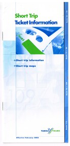 Melbourne Tram Museum
Pamphlet, Yarra Trams, "Short Trip Ticket Information", Feb. 2003
Booklet - 16 pages, center stapled with route tabs, printed in colour on gloss paper, titled "Short Trip Ticket Information", effective Feb. 2003. Outlines the use of Yarra Tram's short trip tickets on the tramway system, and gives details of 7 routes and section details with a map at the time. Second copy added 23-10-15 from Yarra Trams donation. .1 - 12 pages, centre stapled, printed on white paper, titled "Short Trip Tickets", giving information for routes 11, 12, 48, 70, 75, 86, 96, and 109. Has a map for each route and trip information, Metcards. C2001, prior the amalgamation of Yarra and M>Tram.trams, tramways, the met, short trip tickets, tickets, instructions, yarra trams, route 12, route 11, route 48, route 70, route 75, route 86, route 96, route 109 -
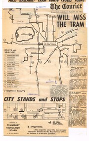 Ballarat Tramway Museum
Newspaper, The Courier Ballarat, "First Ballarat Tram Route closes Today", Aug. 1971
Yields information about the extent of the Ballarat bus services that replaced the tram services in 1971 and their extent.Newspaper cuttings, composite, glued to a ruled or line foolscap sheet with the heading ""First Ballarat Tram Route closes Today", the Courier banner Monday 23/8/1971 (the day after the actual first closure) and a map or advertisement authorised by the Transport Regulation Board of the Ballarat bus routes, details, section points and detailed description of six routes. Would appear to have been compiled from at least two issues of The Courier, possibly by Tom Murray.ballarat, buses, bus routes, map -
 Bendigo Historical Society Inc.
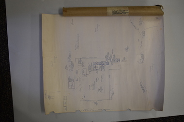
Map - HUSTLER'S REEF MINE - EAST & WEST CROSS-CUTS, NORTH & SOUTH OF SHAFT
East & West Crosscuts, North & South of Shaft, Hustler's Reef Mine Bulletin No 33, Plate No XIX. Map shows main shaft and smaller drawing of section with different stone encountered. Also gives location in relation to the shaft, e. g. 225'E & 150'S of Shaft. Reference diagram to show the different stone and features encountered. Geological Survey of Victoria emblem. Signed by H A Whitelaw, Underground Survey Office Bendigo, September 1913. mining, parish map, hustler's reef mine, east & west cross-cuts north & south of shaft, geological survey of victoria, h a whitelaw, underground survey office bendigo -
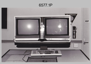 Bendigo Military Museum
Photograph - AITA Award - RA Svy’s AUTOMAP 2 Computer Based Map Production System, Army Survey Regiment, Fortuna, Bendigo, 1984
This collection of three photos of the Australian information Technology Award (AITA) won by the Royal Australian Survey Corps (RA Svy) AUTOMAP 2 computer-based map production system, was taken in 1984 at the Army Survey Regiment, Fortuna, Bendigo. The following article appeared in the ARMY Newspaper on Thursday 21st February 1985. ‘In computerised map production. Survey soldiers lead the world. BENDIGO: Army surveyors have been put on the map as world leaders in computerised map production following the Australian information Technology Awards. RA Svy won the Computer Assisted Draughting – Mapping section for its Automap II System which has created considerable interest among overseas defence experts. The award for the digital mapping system was accepted by OC Air Survey Sqn, MAJ Rob John, who said it was a great morale-booster for the soldiers of the Bonegilla (sic)* -based Army Survey Regiment. "Setting up a state-of-the-art system like Automap II. is an enormous task, " he said. "We started in August 1983 and it's only recently that we have achieved production results. "We were all very pleased to have our efforts recognised in this way. “Of course, credit must also go to the Intergraph Corporation for manufacturing the system and carrying out most of the development." RA Svy is responsible for producing all of Australia's maps used for defence purposes. Its topographical maps have a scale of 1:50,000 or 1:100,000 although Automap II has the capability of producing smaller scale maps - down to 1: 2,000,000. Automap II consists of three computers and three sub-systems: input, raster scanning, and graphic edit. The input sub-system has eight stereo plotters, two interactive graphic workstations and a system manager workstation. The stereo plotters use superimposition optics to digitise features from aerial photographs. It incorporates a voice recognition system so the operator can simply say "House", "Windmill", etc; and the relevant feature will be incorporated in the digital picture. Individual map separations are scanned and converted by the raster scanning sub-system to a digital raster image. This image is then converted to a graphics file in Intergraph format.’ *Note – the Army Survey Regiment was located in Bendigo, not Bonegilla as incorrectly stated in the article. The article appears on Page 137 of Valerie Lovejoy’s book 'Mapmakers of Fortuna – A history of the Army Survey Regiment’ ISBN: 0-646-42120-4. Additional history of the AUTOMAP 2 system with historic photographs is covered in pages 119, 137-143 and 157 of the 'Mapmakers of Fortuna’ book. See item 6223.23P for additional history and photographs of the AUTOMAP 2 system.This collection of three photos of the Australian information Technology Award (AITA) won by the Royal Australian Survey Corps (RA Svy)’s AUTOMAP 2 computer-based map production system, was taken in 1984 at the Army Survey Regiment, Fortuna, Bendigo. The photographs are printed on photographic paper and are part of the Army Survey Regiment’s Collection. The black and white photographs were scanned at 300 dpi. .1) - Photo, black & white, 1984, AITA Award sitting between the dual screens of an AUTOMAP 2 Graphic Edit Workstation. .2) - Photo, black & white, 1984, MAJ Job Johns (centre) and two of Intergraph Corporation IT engineers proudly hold the AITA Award next to an AUTOMAP 2 Graphic Edit Workstation. .3) - Photo, black & white, 1984, The AITA Award displayed on a pedestal in the Army Survey Regiment Officers Mess. .1P to .3P –No personnel are identified. ‘AITI Award to AUTOMAP II 1984’ annotated on cover sleeve. royal australian survey corps, rasvy, army survey regiment, army svy regt, fortuna -
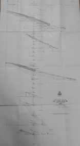 Bendigo Historical Society Inc.
Map - GREAT EXTENDED HUSTLER'S MINE - LONGITUDINAL SECTION OF THE GREAT EXTENDED HUSTLER'S MINE
Longitudinal Section of the Great Extended Hustler's Mine on the Hustler's Line of Reefs. Bulletin No 33, Plate No XIII. Map shows the Hustler's Tribute, 2 Old Shafts, Great Extended Hustler's Shaft, Latham & Watson's Shaft and Ironbark Gully. Datum Line 750 feet above Sea Level. Poppet Legs on the surface and Sill of Shaft 788.99 feet above Sea Level. Levels and their depths are shown and some geographical features. Some amounts of gold mined mentioned. Geological Survey of Victoria emblem and signed by H A Whitelaw, Underground Survey Office Bendigo, September 1913. Note - Plates 4, 8, 13,20, 26 & 31 form a Longitudinal Section from Fortuna Hustlers to Hustler's Consols Mine. mining, parish map, great extended hustler's mine, geological survey of victoria, underground survey office bendigo, h a whitelaw, hustler's tribute, old shaft, great extended hustler's shaft, latham & watson's shaft, ironbark gully -
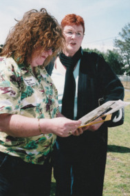
 Port Melbourne Historical & Preservation Society
Photograph - Launch of History of a Street Precinct, 25 Sep
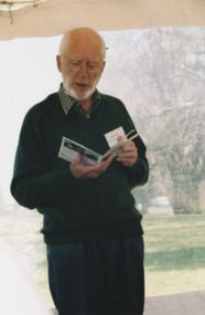
In 2005, members of the PMH&PS undertook a study of the residents of the houses in a Port Melbourne street precinct from the 1880s to 1960. The area is bounded by Evans Street, the E side of Bridge Street, S side of Williamstown Road, Farrell Street both the E & W sides plus the section of Ross Street between Farrell and Bridge and the part of Derham Street between Farrell and Bridge. The resulting map and an interactive CD won the Best Community Research, Registers & Records project at the 2007 Victorian Community History Awards. The project was launched on the railway reserve near the corner of Evans & Farrell streets. Co-author Graham BRIDE.Co-author, Graham Bride, at the launch of the History of a Street Precinct25/9/05 Graham Bridehistory of a street precinct, graham bride -
 Bendigo Historical Society Inc.
Document - BUILDING THE MELBOURNE TO BENDIGO RAILWAY
'BUILDING THE MELBOURNE-BENDIGO RAILWAY'' ( P J MILLAR). Copied from ??? With pages numbered from 19 to 42. Detailed coverage under sections: The builders and designers of the Railway; Some of the bridges along the line (viaducts and tunnels); Ordering of materials and plant; Transport of material; The strikes along the line; Riots on the line; Darbyshire's resignation; Conclusion. Includes 12 figures (poor quality reproduction photos and one map (Contracts for the Main Trunk Lines). One copy without stapling; oneP. J. Millarbendigo, history, bendigo railway, bendigo railway, j. p. millar, captain andrew clarke. -
 Bendigo Historical Society Inc.
Document - H. A. & S. R. WILKINSON COLLECTION: CONTRACT OF SALE
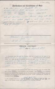
Conditions of sale of private contract dated 20th August, 1938 between G. Rasmussen (vendor) and E. Simmons (purchaser). Property: Freehold described in certificate of title volume 5514 folio 1102695, volume 1786 folio 357169, volume 5012 folio 1002400 transfer 1405137 and all buildings erected thereon. Being all that piece of land coloured purple on said map part of Crown allotment 392 and 393 section H City of Bendigo. Price; 680 pounds.organization, business, h.a. & s.r wilkinson real estate -
 Bendigo Historical Society Inc.
Document - H. A. & S. R. WILKINSON COLLECTION: CONTRACT OF SALE
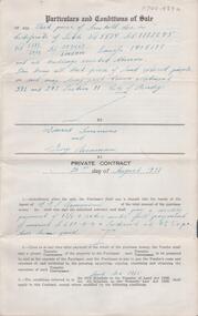
Conditions of sale of private contract dated 20th August, 1938 between G. Rasmussen (vendor) and E. Simmons (purchaser). Property: Freehold described in certificate of title volume 5514 folio 1102695, volume 1786 folio 357169, volume 5012 folio 1002400 transfer 1405137 and all buildings erected thereon. Being all that piece of land coloured purple on said map part of Crown allotment 392 and 393 section H City of Bendigo. Price; 680 pounds.organization, business, h.a. & s.r wilkinson real estate -
 Port Melbourne Historical & Preservation Society
Book - Flannery Family History, Pros & Cons and Cops & Robbers, 2003
Pros & Cons and Cops & Robbers. Book of the Flannery Family history. Sepia and gold cover which is a map of "New Holland". Gold section has the name above words "Common men and women for an uncommon country". "A study through my ancestry by Robin Flannery with Frank Alcorta" Book inscribed on inside first page with names of the three Flannery girls and signed by the author. Latter part of book talks of family in Port Melbourne, including waterside workers, SP bookmaking and police.law, families, police, robin flannery, noelle kinsella, denise o'connor, rita may -
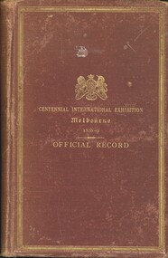 Bendigo Historical Society Inc.
Book - CENTENNIAL INTERNATIONAL EXHIBITION MELBOURNE 1888-9 OFFICIAL RECORD, 1890
Official record of the Centennial International Exhibition Melbourne 1888-1889 containing a sketch of the industrial and economic progress of the Australasian colonies during the first century of their existence and of the exhibition held in Melbourne, Victoria to commemorate the close of that period, also records of the manner in which the work of the different sections of the exhibition was carried out, the official awards of the executive commissioners, the catalogue of exhibits together with sundry illustrations. Published by authority of the executive commissioners, printed by Sands & Mcdougall Ltd 1138 pages with a pull out map.book, exhibitions, exhibitions, centennial international exhibition, awards -
 Melbourne Tram Museum
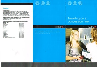
Pamphlet, Metlink, "Travelling on a concession fare" "Public Transport Fares Guide", Dec. 2009
Set of two DL pamphlets issued by Metlink. .1 - Three fold, titled "Travelling on a concession fare", issued Dec. 09, with images of allowable concession cards, notes travelling on both Metcards and Myki. Has contact details, languages and Metlink logos. .2 - Twelve page + cover with fold out maps of the CBD city save section, Metro trains and tram system titled "Public Transport Fares Guide". Centre stapled. Dated Sept. 2011, has Metlink logos.trams, tramways, fares, tickets, metlink, metcard, concession fares, public transport -
 Melbourne Tram Museum
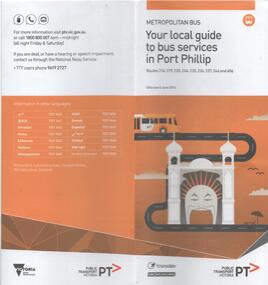
Document - Bus Route Guides, Public Transport Victoria (PTV), "Bus Route Guide - Your local guide to bus services in Port Phillip", 2016
... Maps ...Bus Route Guides, 12 section fold out guide, printed on recycled paper titled "Bus Route Guide - Your local guide to bus services in Port Phillip", detailing the bus services within the City of Port Phillip. Published by the PTV 2016. Has a detailed map of the various routes, and a list of the bus routes and their various stops. Collected as it relates today to the former MMTB Bus routes in the area. Has the logos of PTV, Transdev and CDC Melbourne on the front.trams, tramways, timetables, maps, port melbourne, city of port phillip, buses, south melbourne, st kilda -
 Melbourne Tram Museum
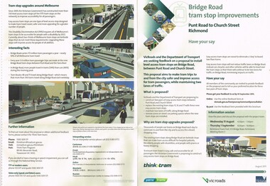
Pamphlet, VicRoads, "Bridge Road tram stop improvements", Sep. 2011
Pamphlet, printed on cream recycled paper, A3 + and A4 tear off titled "Bridge Road tram stop improvements". giving details of the Punt Road to Church St section of Bridge Road tram line. Installation of two level access tram stops to replace the existing three - Vienna style. Has details on the proposal, the background reasons, inviting people to have their say, information sessions, maps, diagrams and contact details and survey form. 2 copies held.trams, tramways, bridge rd, tram stops, vienna style stops, vicroads, disability services -
 Bendigo Historical Society Inc.
Map - HUSTLER'S REEF MINE - TRANSVERSE SECTION OF THE HUSTLER'S REEF MINE
Transverse Section of the Hustler's Reef Mine on the Hustler's Line of Reefs. Bulletin No 33, Plate No XVIII. Shows cross-cuts and their depth, different types of stone and geological features encountered. Drawing of poppet legs at the surface and Sill of Shaft 756.39 ft above Sea Level. Reference Table shows key to the different stone and geographical features encountered. Geographical Survey of Victoria. Signed by H A Whitelaw, Underground Survey Office, Bendigo, September 1913. Thompson's Reef is also mentioned on the map. mining, hustler's reef mine, transverse section of the hustler's reef mine, geological survey of victoria, h a whitelaw, underground survey office bendigo, thompson's reef. -
 Warrnambool and District Historical Society Inc.
Document (Sketch Plan of Dunmore), Stan Baulch, 1972
This card has a sketch map showing the properties surrounding Dunmore on one side and a detailed sketch plan of Dunmore homestead in the early 1970s on the other side. The plan of Dunmore homestead shows interesting features such as the brick oven for bread making, the croquet lawn, the site of the aboriginal mia mias, the Turkish baths and the fowl house used later as a poison house. Francis and Ann Baulch were pioneer settlers in the Kirkstall area and their son Samuel worked at Dunmore in the Macarthur area before purchasing in the early 1870s the property he named Rose Park. In the 1890s he acquired property in the Dunmore estate and his son Stan Baulch gained a section of the Dunmore property after his father’s death. Stan Baulch named this Dunmore section, Rose Park, a property to the west of his father’s original Rose Park property. Stan Baulch was a long time member of the Warrnambool & District Historical Society and he contributed many local history articles and donated many local artefacts to the Society.This sketch plan is of interest as it tells us what the historic homestead of Dunmore in Western Victoria was like in the early 1970s. It will be useful for research. This is a sheet of white lightweight cardboard with a pencilled sketch on one side and a blue ink sketch plan of a house on the other side. The edges of the card have some torn sections. The card is enclosed in an oval cardboard cylinder (recycled and torn at the ends). Both the card and the cover have handwritten titles in ink. Dunmore Homestead & History by S. Baulch Dunmore Homestead drawn by Stan Baulch c.1972 dunmore property, western victoria, baulch family -
 Federation University Historical Collection
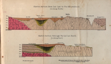
Booklet, Luplau, Hewood & Riderm Printers, The School of Mines Ballaarat Annual Report 1883, 1883
The School of Mines Ballaarat. Annual Report 1883. Statement of Receipts and expenditure, general balance sheet, and list of subscriptions donations 1882. Sketch of School of Mines. Sketch Section from Lal Lal to the Moorabool (looking north) Geological map of Lal Lal. In the County of Grant. Annual Report, Balance Sheet, Certificates granted by the Council, Examination Papers - Elementary Science Classes (Appendix), Extracts from Visitors' Book, Fees, Form of Bequest, Honorary Correspondents. Life Governors, Museum - open to visitors, Notes on the Geology of Lal Lal (with Geological Plan & Sections), Obituary, Office Bearers, Paper of Particulars, Rules of the Ballaarat Field Club and Science Society (Appendix), Report of the Curator of the Museum and Library, Report of the Superintendent of Laboratories, Report of the Lecturer in Mathematics, Report of the Lecturer in Mechanical Engineering, Report of the Lecturer in Telegraphy, Report of the Lecturer in Materia Medica, Statement of Receipts and Expenditure for the year 1882, Subjects and Lectures, Subjects and Examiners, Subscriptions and Donations, from 1st January to 31st December 1882.Ballaarat School of Mines annual Report. Hard cover red book of 101 pages. Includes plans on Lal Lal and surrounds. ballarat school of mines, annual report, balance sheet, certificates granted by the council, examination papers, extracts from the visitors' book, fees, form of bequest, honorary correspondents, life governors, museum, notes on the geology of lal lal, obituary: charles william thomas. one of the examiners in mining and surveying, office bearers, paper of particulars, rules of the ballaarat field club and science society, report of the curator of the museum and library, report of the superintendent of laboratories, report of the lecturer in mathematics, report of the lecturer in mechanical engineering, report of the lecturer in telegraphy, report of the lecturer in materia medica, statement of receipts and expenditure for the year 1882, subjects and lectures, subjects and examiners, subcriptions and donations, from 1st january to 31st december 1882, alf. mica smith, professor of chemistry, alf. mica smith, metallurgy, f. m. krause - professor of geology, mineralogy, scientific mining, t. h. thompson, practical mining, w. h. shaw mechanical engineering, h. reid, mechanical enginnering, phoenix foundry company (limited), a. a. buley, mathematics, f. m. krause, land, mining and engineering surveying, w. d. campbell, telegraphy, james oddie, vice-president, alf. mica smith, natural philosophy (elementary mechanics and hydrostatics, magnetism and electricty, sound, light and heat), j. f. usher, materia medica, pharmacy and physiology, examiner, professor h. m. andrew, m. a., examiner, h. d. de la poer wall, m. a, c. e., examiner, thomas mann, b. a., examiner, p. c. fitzpatrick, c. s., examiner, h. rosale, j.p., f.g.s, m.e. and m, examiner, john lewis, examiner, w. c. kernot, m.a., c.e., examiner, professor mccoy, examiner, j. cosmo newbery, c.m.g., b. sc., examiner, baron von mueller, k.c.m.g., m. et ph. d., f. r.s., examiner, sam. w. macgowan, examiner, w. p. bechervaise, examiner, r. l. j. ellery, f.r.s. govt. astronomer, examiner, f. m. krause, c.e., examiner, j. m. bickett, examiner, n. kent, examiner, a. martin, examiner, r. s. mitchell, examiner, w. h. keast, examiner, p. matthews, examiner, d. milliken, examiner, j. t. richards, examiner, jonathan robinson, examiner, t. h. thompson, examiner, h. brookes allen, m.d., examiner, joseph bosisto, examiner, c. r. blackett, m.l.a., examiner, wm. johnson, analyst to the government of victoria, ferdinand krause, ballarat field naturalists club, ferdinand von mueller, thomas mann, a.a. buley, ferrdinand krause, alfred mica smith, james oddie, william johnson, jonathan robinson, james bickett, r.l.j. ellery, cosmo newbery, ballarat field naturalists -
 Melbourne Tram Museum
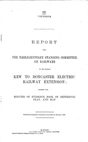
Document - Report, Victorian Parliament, "Report - The Parliamentary Standing Committee on the Proposed Kew to Doncaster Electric Railway Extension", Dec. 1930
Printed - 12 page foolscap, stapled on left hand side, 2 sections, Victorian State Parliamentary Report titled "Report - The Parliamentary Standing Committee on Railways on the Proposed Kew to Doncaster Electric Railway Extension", together with minutes of evidence, book of reference, plan and map, dated 4/12/1930. References a 1928 document, looks at construction costs, sites for railway stations, estimated revenue and expenditure, existing Kew line financials, town planning, bus services, MMTB input, tram services, alternatives, committee views, recommendations and a map of proposed routes, showing roads and tram services. Includes references to the Kodak estate and APM proposals at Fairfield. See Reg Item 2102.3 for the 1928 report.trams, tramways, doncaster, railways, public transport, kew -
Ballarat Tramway Museum
Document - Report, Connell Wagner, "Ballarat Heritage Tram Route Concept Engineering Assessment", 22/03/2002 12:00:00 AM
Forty Eight sheet A4 size document, unbound, printed mainly double sided "Ballarat Heritage Tram Route Concept Engineering Assessment". Produced by Connell Wagner for Booz Allen Hamilton as part of the project study for the return of trams to the central part of the City of Ballarat. Document, dated 1/3/2002. See Reg, Item 2273 for a bound draft version of this document. Has an introduction, looks at the concept for each section of the route with a photograph showing possible route, features, looks at passing loop locations, tram stop locations, substations, potential depot sites, concept construction costs and has maps of preferred route and alternative routes, depot options, concept construction costs, typical track cross sections and costing detail. Has an index.trams, tramways, ballarat city tramway, ballarat revival, civil engineering, depot -
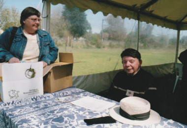
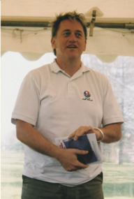
 Port Melbourne Historical & Preservation Society
Photograph - Launch of History of a Street Precinct, 25 Sep
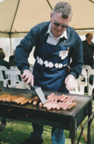
In 2005, members of the PMH&PS undertook a study of the residents of the houses in a Port Melbourne street precinct from the 1880s to 1960. The area is bounded by Evans Street, the E side of Bridge Street, S side of Williamstown Road, Farrell Street both the E & W sides plus the section of Ross Street between Farrell and Bridge and the part of Derham Street between Farrell and Bridge. The resulting map and an interactive CD won the Best Community Research, Registers & Records project at the 2007 Victorian Community History Awards. The project was launched on the railway reserve near the corner of Evans & Farrell streets. Jack BOLT is cooking with Ken TURNER in the background.Jack Bolt cooking sausages at the launch of the History of a Street Precinct25/9/05 Jack Bolt 11jack bolt, ken turner, history of a street precinct -
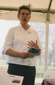
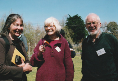 Port Melbourne Historical & Preservation Society
Photograph - Launch of History of a Street Precinct, 25 Sep
In 2005, members of the PMH&PS undertook a study of the residents of the houses in a Port Melbourne street precinct from the 1880s to 1960. The area is bounded by Evans Street, the E side of Bridge Street, S side of Williamstown Road, Farrell Street both the E & W sides plus the section of Ross Street between Farrell and Bridge and the part of Derham Street between Farrell and Bridge. The resulting map and an interactive CD won the Best Community Research, Registers & Records project at the 2007 Victorian Community History Awards. The project was launched on the railway reserve near the corner of Evans & Farrell streets. LL - R - unknown, Pat GRAINGER, Graham BRIDE.Pat GRAINGER, Graham BRIDE at the launch of the History of a Street Precinct project. 25/9/05 Not Known, Pat Grainger, Graham Bridepat grainger, graham bride, history of a street precinct -
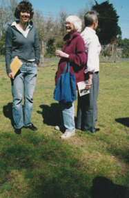 Port Melbourne Historical & Preservation Society
Photograph - Launch of History of a Street Precinct, 25 Sep
In 2005, members of the PMH&PS undertook a study of the residents of the houses in a Port Melbourne street precinct from the 1880s to 1960. The area is bounded by Evans Street, the E side of Bridge Street, S side of Williamstown Road, Farrell Street both the E & W sides plus the section of Ross Street between Farrell and Bridge and the part of Derham Street between Farrell and Bridge. The resulting map and an interactive CD won the Best Community Research, Registers & Records project at the 2007 Victorian Community History Awards. The project was launched on the railway reserve near the corner of Evans & Farrell streets. L- R - Natica SCHROEDER, Pat GRAINGER, Janet BOLITHO.Three members of the PMHPS the launch of the History of a Street Precinct25/9/05 Natica Schroeder, Pat Grainger, Janet Bolithohistory of a street precinct, pat grainger, natica schroeder, janet bolitho -
 Port Melbourne Historical & Preservation Society
Photograph - Launch of History of a Street Precinct, 25 Sep
In 2005, members of the PMH&PS undertook a study of the residents of the houses in a Port Melbourne street precinct from the 1880s to 1960. The area is bounded by Evans Street, the E side of Bridge Street, S side of Williamstown Road, Farrell Street both the E & W sides plus the section of Ross Street between Farrell and Bridge and the part of Derham Street between Farrell and Bridge. The resulting map and an interactive CD won the Best Community Research, Registers & Records project at the 2007 Victorian Community History Awards. The project was launched on the railway reserve near the corner of Evans & Farrell streets. L- R - Val POWER, Jim POWER.Two members of the PMHPS the launch of the History of a Street Precinct25/9/05 Val Power, Jim Powerhistory of a street precinct, val power, jim power -
 Port Melbourne Historical & Preservation Society
Photograph - Launch of History of a Street Precinct, 25 Sep
In 2005, members of the PMH&PS undertook a study of the residents of the houses in a Port Melbourne street precinct from the 1880s to 1960. The area is bounded by Evans Street, the E side of Bridge Street, S side of Williamstown Road, Farrell Street both the E & W sides plus the section of Ross Street between Farrell and Bridge and the part of Derham Street between Farrell and Bridge. The resulting map and an interactive CD won the Best Community Research, Registers & Records project at the 2007 Victorian Community History Awards. The project was launched on the railway reserve near the corner of Evans & Farrell streets. L- R - Robyn ?, Maralyn KOBELTMaralyn & Robin at the launch of the History of a Street Precinct25/9/05 Robyn ?, Maralyn Kobelthistory of a street precinct, maralyn kobelt -
 Port Melbourne Historical & Preservation Society
Photograph - Launch of History of a Street Precinct, 25 Sep
In 2005, members of the PMH&PS undertook a study of the residents of the houses in a Port Melbourne street precinct from the 1880s to 1960. The area is bounded by Evans Street, the E side of Bridge Street, S side of Williamstown Road, Farrell Street both the E & W sides plus the section of Ross Street between Farrell and Bridge and the part of Derham Street between Farrell and Bridge. The resulting map and an interactive CD won the Best Community Research, Registers & Records project at the 2007 Victorian Community History Awards. The project was launched on the railway reserve near the corner of Evans & Farrell streets. Darren Ray, Mayor of City of Port Phillip.City of Port Phillip mayor, Cr Darren Ray at the launch of the History of a Street Precinct25/9/05 Darren Ray Mayor CoPPhistory of a street precinct, darren ray -
 Port Melbourne Historical & Preservation Society
Photograph - Launch of History of a Street Precinct, 25 Sep
In 2005, members of the PMH&PS undertook a study of the residents of the houses in a Port Melbourne street precinct from the 1880s to 1960. The area is bounded by Evans Street, the E side of Bridge Street, S side of Williamstown Road, Farrell Street both the E & W sides plus the section of Ross Street between Farrell and Bridge and the part of Derham Street between Farrell and Bridge. The resulting map and an interactive CD won the Best Community Research, Registers & Records project at the 2007 Victorian Community History Awards. The project was launched on the railway reserve near the corner of Evans & Farrell streets. Janet BOLITHO, former mayor of City of Port Phillip.Former City of Port Phillip mayor, Janet Bolitho, at the launch of the History of a Street Precinct25/9/05 Janet Bolithohistory of a street precinct, janet bolitho