Showing 1059 items matching "boundaries"
-
 Bacchus Marsh & District Historical Society
Map, Parwan Parish Map, County of Grant, 1909
A single page paper map showing the map for the Parish of Parwan in the County of Grant. A cadastral map showing parish boundaries and land ownership. The map is pasted into a bound volume containing 76 maps or plans in total. High resolution digital image stored on BMDHS computer network. Photo-lithographed at the Department of Lands and Survey, Melbourne by T.F. McGauran, 7.7.09. bacchus marsh region parish plans, parwan parish maps, parwan parish plan -
 Bacchus Marsh & District Historical Society
Map, Gorrockburkchap Parish Map, County of Grant c.1906
The parish of Gorrockburkchap (sometimes spelled Gorrockburkghap) lies to the west and south west of the township of Bacchus Marsh. The locality of Rowsley is situated within this parish area.A single page paper map showing the parish plan for Gorrockburkchap in the County of Grant. A cadastral map showing parish boundaries and land ownership The map is pasted into a bound volume containing 76 maps or plans in total. High resolution digital image stored on BMDHS computer network. gorrockburkchap parish maps, rowsley victoria maps, bacchus marsh region parish plans -
 Bacchus Marsh & District Historical Society
Map, Blackwood Parish Map, County of Bourke, 1892
A single page paper map showing the map for the Parish of Blackwood in the County of Bourke. A cadastral map showing parish boundaries and land ownership. The map is pasted into a bound volume containing 76 maps or plans in total. High resolution digital image stored on BMDHS computer network. Photo-lithographed at the Department of Lands and Survey, Melbourne by T.F. McGauran 14.7.92bacchus marsh region parish plans, blackwood parish plan, blackwood parish maps -
 Bacchus Marsh & District Historical Society
Map, Blackwood Parish Map, County of Bourke, 1905
A single page paper map showing the map for the Parish of Blackwood in the County of Bourke. A cadastral map showing parish boundaries and land ownership. The map is pasted into a bound volume containing 76 maps or plans in total. High resolution digital image stored on BMDHS computer network. Photo-lithographed at the Department of Lands and Survey, Melbourne by T.F. McGauran 21.7.05bacchus marsh region parish plans, blackwood parish plan, blackwood parish maps -
 Bacchus Marsh & District Historical Society
Map, Myrniong Parish Map, County of Bourke, 1882
A single page paper map showing the map for the Parish of Myrniong in the County of Bourke. A cadastral map showing parish boundaries and land ownership. The map is pasted into a bound volume containing 76 maps or plans in total. High resolution digital image stored on BMDHS computer network. Photo-lithographed at the Department of Lands and Survey, Melbourne by J. Noone, 17.7.82myrniong parish plan, myrniong parish maps, bacchus marsh region parish plans -
 Lakes Entrance Historical Society
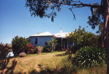
Photograph - Bunga Haven, 1999
Built on site of Northrope's original bark residence (1890c).Colour photograph of a property known as Bunga Haven at 127 Lake Bunga Road. A timber dwelling with corrugated iron roof overlooking Lake Bunga and Bass Strait. Set in rustic garden and native bushland. Dropped log boundary fence and brush gate. Lakes Entrance Victoriaaccommodation, tourism -
 Lakes Entrance Historical Society
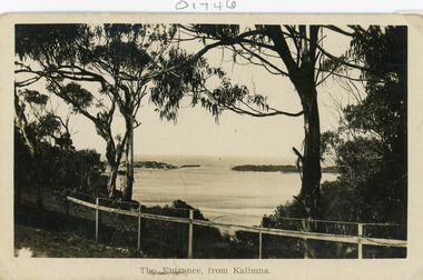
Postcard - The Entrance
Black and white postcard of the man made entrance through the sand hummocks, taken from Kalimna cliff top. In the foreground native vegetation on the cliff top behind simple timber and wire netting boundary fence topped with a single strand of barbed wire. Lakes Entrance VictoriaThe Entrance from Kalimnawaterways, topography, islands -
 Bendigo Historical Society Inc.
Map - MINING REPORTS - MAP OF COLLMANN AND TACCHI SHAFT
Collman and Tacchi shaft drawn on map corner of Dowding Street and Mt. Korong Road, California Gully, Bendigo. Mt Korong Road later became Eaglehawk Road. Hand drawn map showing the Collmann and Tacchi Shaft with No 17 Crosscut with the distances in feet and inches and the compass bearing of each leg. It is beside Mt Korong Road, near Dowding Street. Some boundary lines are drawn. Also on the map is Lansell's C and T across the road.map, bendigo, goldfields, mining reports, map of collmann and tachi shaft, collmann and tacchi shaft, lansell's c and t -
 Eltham District Historical Society Inc
Negative - Photograph, J.A. McDonald, Heidelberg-Kinglake Road, Sep. 1960
Looking north from south boundary of St Andrews Township (Cr. Brinkkotter in car) Noted on album page as September 1960 but photo dated October on reverseRecord of various Shire of Eltham infrastructure works undertaken during the period of 1952-1962 involving bridge and road reconstruction projects, sometimes with Eltham Shire Council Project Reference numbers quoted. It was during this period that a number of significant improvements were made to roads and new bridges constructed within the shire that remain in place as of present day (2022). In many situations, the photos provide a tangible visible record of infrastructure that existed throughout the early days of the Shire. The album was put together by or under the direction of the Shire Engineer, J.A. McDonald.infrastructure, shire of eltham, bridge construction, road construction, cr. a. brinkkotter, heidelberg-kinglake road, st andrews, 1960-09 -
 Ballarat Tramway Museum
Slide - 35mm slide/s - set of 6, Campbell Duncan, 19/09/1971 12:00:00 AM
Yields information about the operations of the Ballarat Tramway system on the last day of SEC tramway operations in Ballarat.Set of 6 Kodak - Kodachrome slides - cardboard mounts - all taken on 19/9/1971, last day of operations prior to closure of the SEC operated tramway. .1 - Tram 40, waits at the level crossing gates - the gates are being opened. In the background is the station building and the signal gantry. Tram has the destination of Sebastopol. .2 - No. 42, with destination of Lydiard St north, northbound in Lydiard St, with railway station buildings and VRI in the background. .3 - No. 35 on inbound, Lydiard St North. .4 - No. 35, on inbound service, leaving Skipton St loop with another bogie in the background. .5 - No. 39 on inbound service, Albert St Sebastopol with the Sebastopol boundary sign and Binks Ford in the background. Tram has an everything under control in my all electric kitchen roof advert. .6 - No. 42, with destination of Sebastopol, Albert St Sebastopol.In ink on slide: .1 - Sun 19 Sept 71 - up Lydiard St Nth waits for gates to be opened after fast goods. .2 - Sun 19 Sept 1971, down Lydiard St Nth near VRI. .3 - Sun 19 Sept 1971, Up Lydiard St Nth .4 - Sun 19 Sept 1971, Up Sebastopol (supplementary service) has just crossed down in Skipton St near Drummond St. .5 - Sun 19 Sept 1971, Up Sebas at Ballarat / Sebastopol boundary. .6 - Sun 19 Sept 1971, c5.30pm down Sebas in Sebas shire.tramways, trams, lydiard st nth, railway station, level crossings, skipton st, albert st, sebastopol, closure, last day, tram 40, tram 42, tram 35, tram 39 -
 Eltham District Historical Society Inc
Document - Folder, Eltham Shire: Guide to historical sources held in the LaTrobe and Reference Library Collections, State Library of Victoria, 1980
Two copies. Folders 68 and 74 from Harry Gilham Collection. "The following work was undertaken at the request of the Shire Planner of the Shire of Eltham to aid in the establishment of a total inforamtion system for the Shire. It is primarily a guide to sources of historical information on the area within the present shire boundaries and also the additional areas which were within the shire's former boundaries". Sources are arranged in the following sections: bibliographies, books and pamphlets, serials, electoral rolls, directories, statistical material, maps, pictorial material and manuscripts.12 pages in a manilla folderWithdrawn copy from Yarra Plenty Regional Librarybibliography, library -
 Heidelberg Golf Club
Book, Melbourne Parks and Waterways, Lower Plenty River concept plan: Maroondah Pipe Track to Yarra River, 1994
Lower Plenty River concept plan: Maroondah Pipe Track to Yarra River. Includes suggestion of Plenty River Trail along the west boundary of the Heidelberg Golf Club.66 p., illus., colour map. Also, Draft copy of document.plenty river trail, lower plenty river, heidelberg golf club, mmbw, melbourne parks and waterways -
 Bendigo Historical Society Inc.
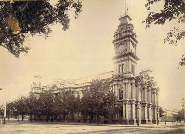
Photograph - BENDIGO TOWN HALL
Sepia image mounted on board. Image shows Bendigo Town Hall taken from north side, looking south down Hargreaves Street. Trees along north boundary of building. Gas lamps alongside kerb in Hargreaves Street. Market building visible alongside Town Hall.bendigo, buildings, bendigo town hall, bendigo, town hall, municipal buildings, hargreaves street -
 Bacchus Marsh & District Historical Society
Map, Trentham Parish Map 1905 Copy 1
A single page paper map showing the map for the Parish of Trentham in the Counties of Dalhousie and Bourke. A cadastral map showing parish boundaries and land ownership. The map is pasted into a bound volume containing 76 maps or plans in total. High resolution digital image stored on BMDHS computer network. Photo-lithographed at the Department of Lands and Survey, Melbourne by T.F. McGauran 22.3.05 trentham parish maps, trentham parish plan, bacchus marsh region parish plans -
 Clunes Museum
Map, 1962
.1 &.2 MAP OF BALLARAT SHIRE GROUP RURAL FIRE BRIGADES FIRE CONTROL MAP. COMPILED BY C. H. FENTON. (2 COPIES) DETAILING SEALED ROADS, STATE FORESTS, PINE PLANTATIONS, FOREST AREAS, RAILWAYS, BOUNDARIES, TOWNSHIP AREAS CEMETERIES, CREEKS, SWAMPS AND HOUSES.local history, document, maps, fire brigade -
 Greensborough Historical Society
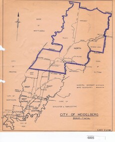
Map, City of Heidelberg, City of Heidelberg, 1962, 02/02/1962
Map of City of Heidelberg showing boundaries of its six wards; North Ward is highlighted, covering Watsonia, Greensborough, part Bundoora, St Helena, Plenty, Yarrambat and Diamond Creek.Blue print mapCity of Heidelberg Scale: 1" to 1 ml. G.M.H. 2.2.62city of heidelberg, heidelberg - maps -
 Friends of Ballarat Botanical Gardens History Group
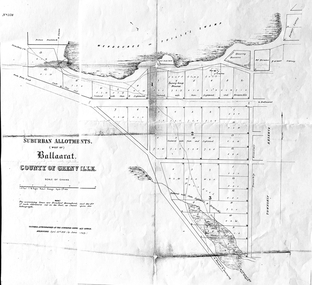
Work on paper - Suburban Allotments (west of) Ballaarat, Wendouree or Yuille's Swamp, County of Grenville 30/4/1856, 30/4/1856. No date given for photocopy
This map of the 1856 survey shows the numbered suburban allotments and the boundaries surrounding this area including Wendouree or Yuilles's Swamp close to where the Ballarat Botanical Gardens and the Lake exist today. This map gives a clear idea of an early survey of this western area and directions to areas of Ballarat surrounding these allotments.2 pages of the same map, except p.2 shows the Township Reserve on the lefthand side of the page. On the back of p.2, righthand corner is the Public Records Stamp.P2, righthand corner is the citation in pencil.john garner, doctor john garner, ballarat botanical gardens, friends of ballarat botanical gardens, map of western suburban allotments 1856, county of grenville, public record office of victoria, john garner collection, gardens, ballarat -
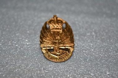 Wangaratta RSL Sub Branch
Badge - Gold Badge
WW2 War Service Badge issued to former soldiers who had served within the boundaries of Australia and who were, therefore, not eligible for the RAS badge. To be worn on civilian clothing.Gold badge with crown on top, rising sun in middle, an anchor at the bottom.On front: Service at bottom of crown. Australia is written at bottom, under anchor. On back: 1948, Issued by C'Wealth Govt, Amor Sydney. 49241australia, wwii, world war 2 -
 Bendigo Historical Society Inc.
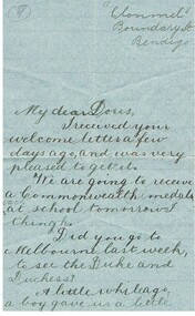
Document - MALONE COLLECTION: MACOBOY LETTERS, 1907
2 handwritten letters from Cecily Macoboy 'Clonmel' Boundary St Bendigo (now Valentine St) to her friend Doris. Also included is a piece of paper addressed to Doris from Kathleen. Part of this is written in French, and on the larger side what appears to be a song and the notes required to play this music.Cecily Macoboyperson, family, malone collection, malone collection, macoboy letters, cecily macoboy -
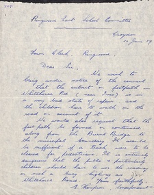 Ringwood and District Historical Society
Letter - clipping, Letter to Town Clerk Ringwood 1939 from Ringwood East Primary re Footpath culvert
A letter dated 30 June 1939 to the Town Clerk Ringwood from E Thompson Ringwood East School Committee advising the Council that the culvert on footpath in Whitehorse Road is in a very bad state of repair. Also requesting that the footpatch be formed or continued along from the Burnt Bridge to the municipal boundary. -
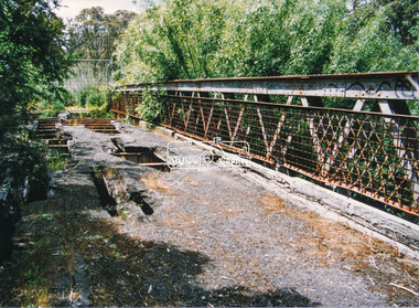 Eltham District Historical Society Inc
Photograph, Doug Orford, Lower Plenty Bridge, Old Eltham Road, Lower Plenty, 1998
Originally the boundary between the former Shire of Eltham and the City of Heidelberg, a toll gate existed on the Eltham side. The bridge has since been restored and is now part of the Plenty River Trail.Two colour photograph prints 10 x 15 cm (2 copies)bridges, lower plenty, main road, plenty river, old eltham road -
 Bayside Gallery - Bayside City Council Art & Heritage Collection
Map, Department of Crown Lands and Survey et al, Moorabbin, County of Bourke, Government Roads, 1920
The cadastral map of the Parish of Moorabbin in Victoria (L.6104) shows parish boundaries and land ownership 1920 when Sandringham was a Town. The government roads have been coloured in red pencil.moorabbin, county of bourke, map, plan, land subdivision, land titles, foreshores, hampton, beaumaris, highett, cheltenham, department of lands and survey, land owners, cartographic material, brighton, sandringham, town of sandringham, government roads -
Beechworth Honey Archive
Map- Albury
Map centred on Albury, showing Wodonga, Beechworth, Yackandandah and Chiltern. Topographic survey scale 1:100,000. Map is colour, printed on paper. Produced by Department of Minerals and EnergySheet 8225 (ed.1) series R. 652 Notes written on side regarding brigade boundaries, constructed access roads and fire trails, dams suitable for quick fill pump and areas 'fuel reduction burns Autumn 76'.map, albury, wodonga, beechworth, yackandandah, chiltern, paper, topographic, beechworth honey -
 Ringwood and District Historical Society
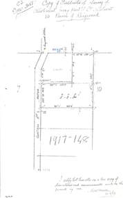
Document - Copy of Lands Department Field Notes - Parish of Ringwood, Victoria, Field Notes 1917/148 - Part of O.P. R72 - Crown Allotment 10, surveyed June 1917
5614b Foolscap size photocopy of survey map with handwritten notations. References include Wantirna Road, to Ringwood Station, Reilly Street, J. Marshall, fence to be erected on boundary, I certify that these notes are a true copy of observations and measurements made on the ground by me (signed) H.W. Moore 22/6/17. -
 Bendigo Historical Society Inc.
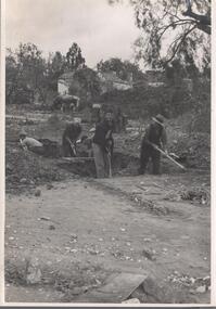
Photograph - Nell Gwynne Main Shaft, 1934
Significant to mining history of Bendigo.Black and white photograph of five men standing on surface starting to dig a mine shaft. One man is wearing a jumper with 'CFC" (Carlton Football Club ?) on front. String lines are set out to define the boundary of the shaft. In background, weatherboard house depicted in (11032.11 and 11032.12), and a cow standing alongside house. Written in pencil on back of photograph in black pen: 'Nell Gwynne main shaft starting 26/9/34'nell gwynne gold mine, shaft -
Glen Eira Historical Society
Document - Goldstein, Vida
One item on electoral division of Goldstein. Profile details of electoral division, updated 22/02/2012 plus map showing boundaries of Electoral Division of Goldstein gazette 24/12/2012.electoral boundaries, ‘goldstein’, vida goldstein, suffragist, feminist movement, maps -
 Bendigo Historical Society Inc.
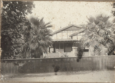
Photograph - T C WATTS & SON COLLECTION: BENDIGO HOUSE, 1927
Brydon Stewart Melrose (1895-1989) was a dentist. He married Florence Emily Reville in 1921. Their home in Myrtle Street was called Morayfield. In the mid to late 1930's they moved to Boundary Street.Black and white photograph mounted on rectangular grey board. House, weatherboard, cement sheet and timber under eaves. Double door entrance. Rough cast cement verandah with timber posts. Two palms in front. Timber top rail to closely slatted wooden fence, chimney pots visible. On back of photo:" Bryden Melrose, £850, Date stamp 9 December 1927. refer S & U, D.T. Coy first'Frank A. Jeffree Bendigoplace, building, residential, stamped on back in rectangle ''t.c. watts and son/auctioneer/estate agents/253 mitchell street/bendigo'' stamped on back in circle ''royal historical society of victoria, bendigo branch'' -
 Eltham District Historical Society Inc
Photograph - Black and White Print, Old settler's cottage, Floods Lane, North Warrandyte, c.1935
An early settler's cottage of 1920s vintage near Floods Rd taken in the 1930s. Was originally Floods Lane and became Floods Road off Kangaroo Ground-Warrandyte Rd near boundary of North WarrandyteInscribed in pencil on reverse "early 20's near Flood Rd taken 30's. 21/1.89" and in pen ".16/1.80"cottage, floods lane, floods road, houses, kangaroo ground-warrandyte road, north warrandyte, pioneers -
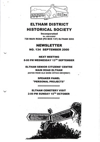 Eltham District Historical Society Inc
Newsletter, Newsletter, No. 134 September 2000
Contents: • Next meeting, Speaker Panel: Personal Projects • September Meeting • Eltham Cemetery Visit • Kangaroo Ground Boundaries • Chronology • ‘Not Just a Pretty Place’ • Family Histories of Eltham • Other News Items The Shire of Eltham Historical Society was formed in October 1967. The first newsletter of the Society was issued May 1978 and has been published continuously ever since on a bi-monthly basis. With the cessation of the Shire of Eltham in late 1994, the Society's name was revised to Eltham District Historical Society and this name first appeared with issue No. 103, July 1995. The collection of the Society's newsletters provides a valuable resource on the history of the Society's activities, office bearers and committee members, guest speakers and subjects of historical interest pertinent to the former Shire of Eltham and the Eltham District.A4 photocopied newsletter distributed to membersnewsletter, eltham district historical society, shire of eltham historical society -
 Ballarat Tramway Museum
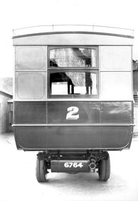
Photograph - Geelong Tramways MESCo bus No. 2
Rear of MESCo's bus No. 2, built for their East Geelong route between the East terminus at Boundary Road and the railway station or Moorabol St. wharf. Note the twin rear tyres. Looks new, 1912.Black and white print on paper.No. 1 inside a circle written on the reverse in pen. 14-2 and GRS710/14/1/2 written n the reverse in pencil.geelong tramways, mesco bus no. 2