Showing 968 items matching "dam"
-
 Whitehorse Historical Society Inc.
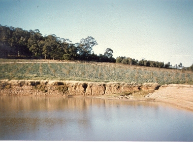
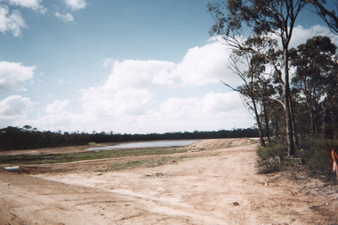
Photograph, Livermore's Orchard
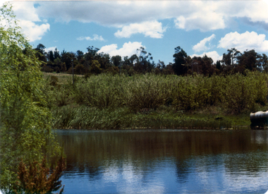
Coloured photo of dam on Livermore's Orchard, Morack Road, Vermontlivermore, clem, douglas, orchards -
 Ballarat Heritage Services
Photograph, Maryborough Water Supply
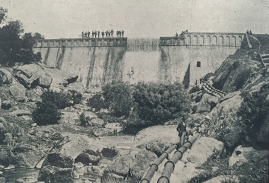
Photograph of men standing along a dam wall at Maryborough, Victoria.maryborough, maryborough water supply -
 Linton and District Historical Society Inc
Photograph, Dredge hut, Granny's Paddock
Black and white photograph of a hut located beside a dam of water.dams, mines, dredging, buildings, huts, granny's paddock -
 Kiewa Valley Historical Society
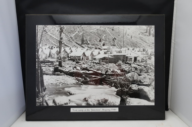
4 Photos framed - Kiewa Hydro Electric Scheme 1940s
These 4 black and white photos are very clear and are of Bogong in the 1940s when the Kiewa Hydro electric Scheme was being constructed. Bogong was the first construction site. Bogong was a township and construction site for the Kiewa Hydro Electric Scheme built by the State Electricity Commission of Victoria. These photos in the early 1940s (during WW2) tell the story of fire, flood and living conditions with the inference of transport being horses in 1940 compared with its development in 1944.1. Tent camp at the 'Junction', Bogong 1940 2. Junction Dam September 1940: floodwaters over coffer dam 3. 'Reservoir' Camp with Bogong Stables in foreground, 1940 4. Junction Dam and Bogong village in August 1944 Each photo has string attached on the back with tape - for hangingSticker on the back of each photo: 'Framing/ Colour Magic / Shop 7, Lismore Central / Carrington Street, Lismore / Phone (02) 6621 3289'bogong township 1940, junction dam 1944, reservoir camp 1940, bogong stables 1940, tent camp at bogong -
 Rutherglen Historical Society
Image, October 1929
Photocopies of Hume Weir photographs 1928-29One of two black and white photographs, photocopied onto a single sheet of A4 paper. This one is of construction work on a dam, showing lower part of dam wall, and featuring one of the valves.Written on paper next to photo: "Needle valve Hume Weir Albury Oct '29"hume weir, construction, dam construction -
 Southern Sherbrooke Historical Society Inc.
Photograph - Photo-colour- Bill Montague boat
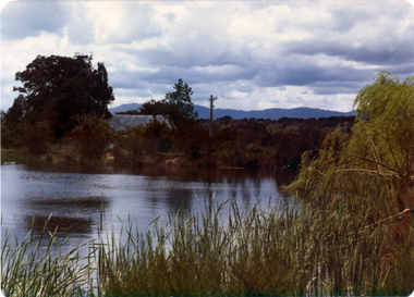
Colour photograph of Bill Montague on his boat, on the dam at the orchard at Narre Warren. Bill is the only person on his boat whichmoves alone in the water as the dam bank and trees surround him. -
 Wodonga & District Historical Society Inc
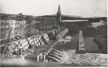
Album - Hume Reservoir Australia Album - Section of completed coffer dam, January 1927
This set of photos is from a leather bound album bearing the inscription "HUME RESERVOIR AUSTRALIA" plus 'The Rt. Hon. L. C. M. S. Amery, P. C., M .P.' all inscribed in gold. It was presented to The Rt. Hon. L. C. M. S. Amery, P. C., M. P, Secretary of State for Dominion Affairs on the occasion of his visit to the Hume Reservoir on 2nd November 1927. This album is of local and national significance as it documents the planning and development of the Hume Reservoir up to 1927. It was the largest water reservoir in the British Empire. The album records the pioneering engineering work that went into its construction.DEPARTMENT OF PUBLIC WORKS, N.S.W. RIVER MURRAY WATERS SCHEME. HUME RESERVOIR. 20. Section of completed coffer dam with river diverted over the concrete foundations of dam that were placed during the first stage of operations. New South Wales. January 1927. Cofferdams are temporary structures used where construction is being carried out in areas submerged in water. They are most commonly used to facilitate the construction or repair of dams, piers and bridges. To divert the river, a Coffer Dam was built across the old bed above and below the Dam site and tying into the end of the concrete wall built inside the levee bank. This completely surrounded the remainder of the site of the Dam and south wing wall, including an area of 12½ acres. hume reservoir australia, river murray waters scheme, hume reservoir construction -
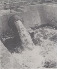
 Tatura Irrigation & Wartime Camps Museum
Photograph, 13/04/1918
Taken by photographer for State Rivers and Water Supply Commission.Medium sized black and white photograph. Eildon Reservoir overall picture / dam wall and construction huts left of middle / dam filled with water right of wall / tree covered hills beyond.goulburn weir, victorian state rivers and supply commission -
 Bendigo Historical Society Inc.
Slide - Peter Ellis Collection, Kaweka Wildflower Reserve, Castlemaine, Lightning Hill Lookout Bendigo, One Tree Hill Lookout Tower Bendigo, Kamarooka Forest Area, c1970-1972
Kaweka Reserve is a a small reserve of approximately 8ha. The land was donated to the Castlemaine City to be a wildflower Reserve. A management committee was formed in 1966. The committee is still managing the park. Vicroads Edition 6: Map 59E2, 628 H4 Location. Turner St, Castlemaine. From the Castlemaine Post Office, drive north (towards Bendigo) and turn right along Turner Street to the park entrance. What to do: walk along some of the tracks through the park follow the nature trail bird watch have a picnic at the picnic tables. RUSH Dam is a basic free camping area sits alongside Rush Dam in the Greater Bendigo National Park, featuring a single picnic table and wood fire barbecue.Peter Ellis Collection: Seventeen slides of Kaweka Wildflower Reserve, Castlemaine, Lightning Hill Lookout Bendigo, One Tree Hill Lookout Tower Bendigo. Also the Rush Dam free camping area at Kamarooka. Also a slide of an unknown group having a meal or day out; perhaps also a working bee. In addition there are two slides of a house - location not specified; and a working bee clearing along a pipeline at Big Hill. Peter was a chemistry lecturer at the Bendigo Institute of technology.history, bendigo, peter ellis collection, whipstick bendigo, bendigo state forests, kaweka wildflower reserve castlemaine, one tree hill lookout bendigo, lightning hill lookout bendigo, kamarooka, rush dam kamarooka, greater bendigo national park -
 Stawell Historical Society Inc
Slide, Ian McCann, Constucting Lake Bellfield
The Dam wall at lake Bellfield looking towards the halls Gap Roadlake bellfield -
 Whitehorse Historical Society Inc.
Photograph, Livermore's Orchard
Coloured photo of Livermore's Orchard, Morack Road, Vermont showing dam.livermore, douglas, clem, orchards -
 Rutherglen Historical Society
Image, c1935
Donated by Mrs A Terrill, member of Rutherglen Historical SocietyBlack and white reproduction of unmounted photograph of Hume Weir dam wallOn back of photo: "Construction of Hume Weir"hume weir, dam construction -
Tatura Irrigation & Wartime Camps Museum
Photograph, 24/3/1917
Taken by photographer for State Rivers and Water Supply Commission.Medium sized black and white photograph. Sugarloaf Reservoir construction of core wall and tower / Rail trucks on single line bottom centre / Traction engine and pump in timber shed lower right / Horses and carts on bank beside upper dams/ words printed:"Upper Dam Core Wall , Bed Rock, Lower Dam."victorian state rivers and supply commission, sugarloaf reservoir -
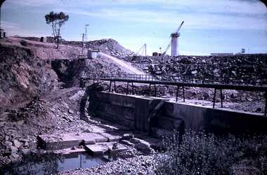
 Kew Historical Society Inc
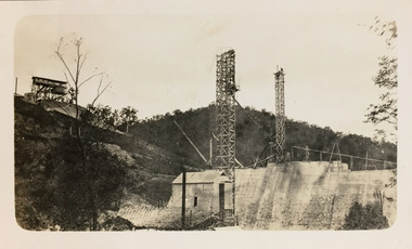
Photograph - Construction of Maroondah Dam, c.1926
Henry Beater Christian (1886-1962) , was a descendant of one of the earliest settler families in Kew. Employed at the Kew Asylum as a 'public servant', he was a skilled amateur photographer, photographing numerous scenes in Kew and on his travels around Victoria. The majority of his photographs date from 1916 to 1929. His finest photographs are housed in two photograph albums. Digital copy of a photograph from page 22 of the 47-page photograph album containing 261 gelatinous silver images, loaned by Diane Washfold with given to digitise and hold a copy in our collection. This photograph, dating from the 1920s, shows a dam wall being constructed. The dam is probably the Maroondah Dam which was built by the MMBW in the 1920s. henry beater christian (1886-1962), landscape photography, christian-washfold collection, photograph albums, water catchments -- melbourne (vic.), dam walls, maroondah dam -
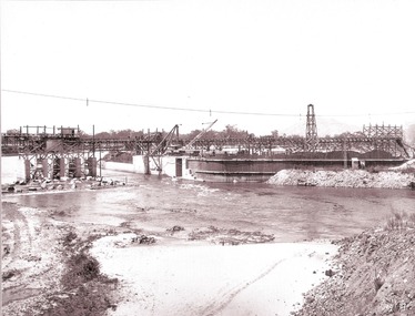
 Wodonga & District Historical Society Inc
Album - Hume Reservoir Australia Album - Excavations for foundations inside coffer dam, January 1927
This set of photos is from a leather bound album bearing the inscription "HUME RESERVOIR AUSTRALIA" plus 'The Rt. Hon. L. C. M. S. Amery, P. C., M .P.' all inscribed in gold. It was presented to The Rt. Hon. L. C. M. S. Amery, P. C., M. P, Secretary of State for Dominion Affairs on the occasion of his visit to the Hume Reservoir on 2nd November 1927. This album is of local and national significance as it documents the planning and development of the Hume Reservoir up to 1927. It was the largest water reservoir in the British Empire. The album records the pioneering engineering work that went into its construction.DEPARTMENT OF PUBLIC WORKS, N.S.W. RIVER MURRAY WATERS SCHEME. HUME RESERVOIR. 21. Excavations for foundations inside coffer dam. New South Wales. January 1927. Cofferdams are temporary structures used where construction is being carried out in areas submerged in water. They are most commonly used to facilitate the construction or repair of dams, piers and bridges. To divert the river, a Coffer Dam was built across the old bed above and below the Dam site and tying into the end of the concrete wall built inside the levee bank. This completely surrounded the remainder of the site of the Dam and south wing wall, including an area of 12½ acres. hume reservoir australia, river murray waters scheme, hume reservoir construction, coffer dam -
Tatura Irrigation & Wartime Camps Museum
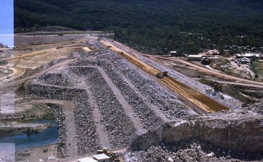
Photograph, Big Eildon Under Construction, 1954
Taken by photographer for State Rivers and Water Supply Commission. Taken at Mount SugarloafLarge sepia photograph. Rocks and uprooted trees in foreground, temporary wooden huts and truck, middle distance terraced earthen dam wall, left of wall water dammed back rounded hills beyond.Bottom edge of photo: "State Rivers and Water Supply Commission / BIG EILDON UNDER CONSTRUCTION."victoria state rivers and water supply commission, eildon, eildon dam -
Tatura Irrigation & Wartime Camps Museum
Photograph, Eildon Township, 1957
Taken by photographer for State Rivers and Water Supply Commission.Medium sized black and white photo. Aerial photograph - looking down on township in middle foreground - overflow dam to the right, middle distance - dam wall with reservoir beyond - mountain tops forming horizonOn frame below photo: "Eildon Township."victoria state rivers and water supply commission, eildon -
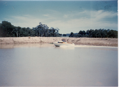
 Southern Sherbrooke Historical Society Inc.
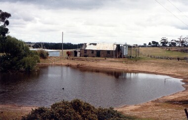
Photograph - The dam, Montague Orchards
Colour photo of the dam at Montague Orchards in Narre Warren North. Photo shows a partially filled dam with dug-out sides, a paddock with planted rows of glaucous green plants, and beyond that is bushland on a ridgeline. -
Glenelg Shire Council Cultural Collection
Photograph, n.d
Sourced from Casterton Town Hall (Former Shire of Glenelg)Coloured photograph. Same subject as 7293, different viewBack: 'FIRE PREVENTION DAM CHETWYND' hand printed in blue biro -
 Kew Historical Society Inc
Photograph - Construction of Maroondah Dam, c.1926
Henry Beater Christian (1886-1962) , was a descendant of one of the earliest settler families in Kew. Employed at the Kew Asylum as a 'public servant', he was a skilled amateur photographer, photographing numerous scenes in Kew and on his travels around Victoria. The majority of his photographs date from 1916 to 1929. His finest photographs are housed in two photograph albums. Digital copy of a photograph from page 22 of the 47-page photograph album containing 261 gelatinous silver images, loaned by Diane Washfold with permission given to digitise and hold a copy in our collection. This photograph, dating from the 1920s, shows a dam wall being constructed. The dam is probably the Maroondah Dam which was built by the MMBW in the 1920s. henry beater christian (1886-1962), landscape photography, christian-washfold collection, photograph albums, water catchments -- melbourne (vic.), dam walls, maroondah dam -
Glenelg Shire Council Cultural Collection
Photograph - Photograph - Earth Saving Dam, n.d
Sourced from Casterton Town Hall (Former Shire of Glenelg)Black and white photo. Large concrete pipe? Part of earth-saving dam -
 Bendigo Historical Society Inc.
Slide - VAL DENSWORTH COLLECTION: DRY LAKE EPPALOCK, May 2004
Slide. Dry Lake Eppalock. A body of water at the tower near the dam wall.slide, bendigo, dry lake eppalock., dry lake eppalock. -
 Tarnagulla History Archive
Photograph: Dam at Reef Mining, Tarnagulla, September 17, 1996
Donald Clark Collection. A colour photograph depicting the dam at Reef Mining Co., Tarnagulla Original photograph. -
 Tarnagulla History Archive
Photograph: Dam at Reef Mining, Tarnagulla, September 17, 1996
Donald Clark Collection. A colour photograph depicting the dam at Reef Mining Co., Tarnagulla Original photograph. -
 Linton and District Historical Society Inc
Photograph, Woolshed, 1982
Colour photograph of brick and tin farm buildings in rural setting, with dam in foreground.buildings, woolsheds, agricultural activity -
 Wodonga & District Historical Society Inc
Album - Hume Reservoir Australia Album - Driving first row of piles for coffer dam across the river, December 1925
This set of photos is from a leather bound album bearing the inscription "HUME RESERVOIR AUSTRALIA" plus 'The Rt. Hon. L. C. M. S. Amery, P. C., M .P.' all inscribed in gold. It was presented to The Rt. Hon. L. C. M. S. Amery, P. C., M. P, Secretary of State for Dominion Affairs on the occasion of his visit to the Hume Reservoir on 2nd November 1927. This album is of local and national significance as it documents the planning and development of the Hume Reservoir up to 1927. It was the largest water reservoir in the British Empire. The album records the pioneering engineering work that went into its construction.DEPARTMENT OF PUBLIC WORKS, N.S.W. RIVER MURRAY WATERS SCHEME. HUME RESERVOIR. 19. Driving first row of piles for coffer dam across the river. New South Wales. December 1925. Cofferdams are temporary structures used where construction is being carried out in areas submerged in water. They are most commonly used to facilitate the construction or repair of dams, piers and bridges. To divert the river, a Coffer Dam was built across the old bed above and below the Dam site and tying into the end of the concrete wall built inside the levee bank. This completely surrounded the remainder of the site of the Dam and south wing wall, including an area of 12½ acres. hume reservoir australia, river murray waters scheme, hume reservoir construction -
 Bendigo Historical Society Inc.
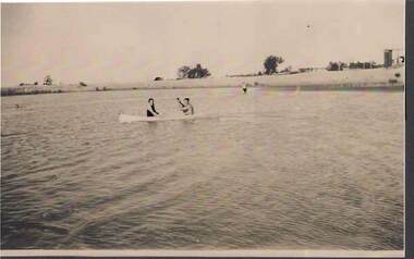
Photograph - QC BINKS COLLECTION: TWO PEOPLE IN CANOE
sepia copy of original. Image shows two people in canoe on dam. Notation : Cliff Binks and Inez Oliver canoeing on the Blue Mine Dam. Roughly at back of where Mitre 10 store is located today. 1938person, individual, blue mine dam, bendigo, binks, blue mine dam -
 Linton and District Historical Society Inc
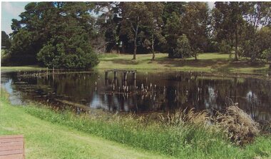
Photograph, Site of Former Linton Swimming Pool, Edinburgh Reserve, Linton, 2014
The photograph was taken by Gary Hunt in 2014.One of three colour photos printed on a single sheet of photographic paper. The photograph shows the section of the Edinburgh Dam which was at one time used as Linton's swimming pool. Remnants of a diving tower can be seen in the dam.edinburgh dam, swimming pool, edinburgh reserve linton -
 Bendigo Historical Society Inc.
Slide - DAVID MCDONALD COLLECTION: EPPALOCK. CONSTRUCTION, c1960
Eppalock. Construction. Construction of the water outlet under the wall of the dam, near the water tower.Agfacolorcivil engineering, water supply, eppalock -
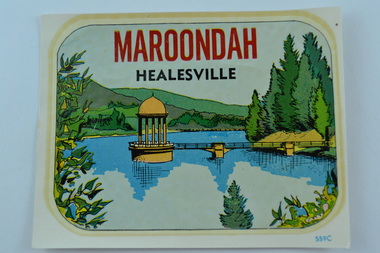 Melbourne Water
Maroondah, Healesville Souvenir Car Sticker
The Maroondah System was first and foremost developed as a functional component of Melbourne's Water Supply System. In addition to functionality, the Melbourne and Metropolitan Board of Works (MMBW) envisioned the Maroondah Reserve to be enjoyed aesthetically and recreationally by the public. This souvenir illustrates the realisation of the Maroondah System as a local recreational and tourist attraction in the early 20th century. The Maroondah Reserve gardens were landscaped with English-style ornamental stonework, exotic trees, flower beds and rose gardens. All features of the water supply system became widely celebrated as beauty spots that continue to be very popular to this day with tourists and locals alike. This souvenir is a product of that flourishing tourist trade. These water supply sites continue to enhance Melbourne’s charm and liveability and are now recognised as places of cultural and historic significance.This souvenir item has been curated by Melbourne Water as it represents an important historical aspect of the organisation by demonstrating the popularity of its water asset sites as recreational places and tourist attractions, and although these sites are functional parts of the water supply system, they were also designed to be enjoyed by the public both aesthetically and recreationally. Souvenir car sticker with a colourful design of Maroondah Dam in Healesville with car sticker instructions.melbourne metropolitan board of works, mmbw, maroondah, dam, healesville, melbourne water, scenic view, souvenir, sticker, car, instructions