Showing 444 items matching "diggings"
-
 Bendigo Historical Society Inc.
Document - The Red Ribbon Rebellion and the Bendigo Petition, 1967
Nine page photocopy of document titled: ' The Red Ribbon Rebellion & the Bendigo Petition. A proposal to commemorate a significant event in the history of Bendigo'. Contents includes a brief history of the Red Ribbon movement; description of the Digger's Banner; information on Governor LaTrobe; William Dixon Campbell Denovan and an outline of the proposed project to commemorate the event. The imposition of a license fee imposed upon the miners, by the Government of Victoria, cause a major agitation on the Bendigo diggings and the Anti-License League was born in Bendigo. Signatures were gathered for a petition: 'It is widely believed that more than 23,000 signatures had been gathered from diggers across all the nearby goldfields; most of those were said to have been lost in the McIvor Escort Robbery of 20 July 1853'. The proposal was prepared by Geoff Hocking in consultation with the Bendigo Historical Society and Jim Evans of the Red Ribbon Repertory Co.mining, sandhurst, red ribbon rebellion, agitation, denovan, latrobe, miners, license fee, diggers -
 Warrnambool and District Historical Society Inc.
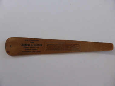
Artefact, Cardboard tie preserver. Cramond & Dickson, Circa 1930's
John Glass Cramond 1829 and James Dickson 1831-1910 were founders of a large drapery store. Both were Scots and both came separately to Australia in 1852. Cramond initially came for gold but soon opened a store in St Kilda with a post Office attached and he was the first post master there. Dickson was a farmer’s son but became a draper and while he was unsuccessful on the Bendigo diggings and then returned to Melbourne where he met Cramond and soon after they opened a store on Lonsdale Street. They opened their business in Warrnambool in 1855 as a general store with groceries, drapery and ironmongery. Both partners were involved with the community and James Dickson was an original director of the Warrnambool Woollen Mill 1909 and the Warrnambool Cheese and Butter Factory. He also served on the committee of management of Warrnambool Base Hospital. The business in the late 1970's. This shape preserver would have been an item given to customers to maintain their tie in good condition. The shape would indicate that it would have been used around mid 20th century.A common object from one of Warrnambool's longest established businesses.Brown cardboard in the shape of a gentleman's tie with a hanging hole on one end and black text with company details and instructions for use. front surface is smooth while the back is coarse.With Compliments from Cramond & Dickson Tailors, Mercers and general Drapers. Warrnambool and London. warrnambool, cramond & dickson -
 Eltham District Historical Society Inc
Photograph - Digital Photograph, Alan King, Queenstown Cemetery, Smiths Gully Road, St Andrews, 28 December 2007
The discovery of gold in Smyth's Creek in 1854 and subsequent gold rush to the Caledonia diggings led to the establishment of Queenstown (present day St Andrews). The first recorded burial was July 31st, 1861 and it was officially declared a Cemetery Reserve in 1866. Many graves are unmarked and unrecorded including many Chinese and other itinerant miners. The cemetery was closed for new burials in 1851. The last recorded burial was in 1981 in an existing family grave. In Loving memory of David Band Died 30th Decr. 1862, aged 51 years. John Cork Knell Died 11th April 1867, aged 42 years. Eliza Smith Died 20th Jany. 1874, aged 3 1/2 years. William Band Died 20th Feby. 1883, aged 51 years. Published: Nillumbik Now and Then / Marguerite Marshall 2008; photographs Alan King with Marguerite Marshall.; p73 The discovery of gold at Smyth’s Creek* in 1854 brought 3000 people to the area in search of their fortunes.1 However in the harsh conditions many miners and their families died young, and were buried in unmarked graves. Their stories died with them but by 1861, the first burial was recorded at the Queenstown Cemetery – that of William Dalrymple aged 65 – although the cemetery was only officially declared a reserve in 1866. Even before this in 1856, a double burial had been recorded for the twin baby daughters of George Harrison at Market Square, the miners’ settlement – presumably where the cemetery is today. In 1951 the Queenstown Cemetery at 70 Smiths Gully Road, Smiths Gully, closed for burials. However the last burial in a family plot, that of Grace Evelyn Smith, occurred in 1981. Today only 55 headstones remain, but more than 380 burials are recorded. Remnant bushland dominates the cemetery where many graves are merely mounds and others have been damaged by vandalism and the neglect of time. Bushfire in 1962 destroyed the picket fencing, grave markers and cypress boundary planted in the early 1900s. The box/stringybark woodland in the 1.7 hectare Cemetery Reserve is regrowth from then and the indigenous and heritage vegetation is protected. Thanks to the volunteer Cemetery Trust and Friends & Relations of Queenstown Cemetery, the cemetery is maintained, stories recorded and the burial index corrected and expanded.2 Close by the cemetery on the site of today’s Peter Franke Picnic and Nature Reserve stood Market Square, the Caledonia Diggings village of tents and stores, the forerunner of Queenstown, now St Andrews. Many of the Caledonia Diggings miners were Chinese, many of whom, with itinerant prospectors, were buried in unmarked graves. Histories are being recorded of other immigrants, mainly English and German, who settled after the gold rush, some of whose descendants fought and died in the two world wars. Names on many headstones are also recorded on the district’s roads, reserves and war memorials such as Motschall, Joyce, Howard and Coutie. The oldest surviving tombstone is that of Scot, David Band who died in 1862 at 51 years. His oldest daughter Elizabeth, with husband John Knell, owned the Queenstown Hotel and the post office. Child-rearing in a colonial gold town was often tragically difficult, as demonstrated in the first 20 years, when 41% of the 34 burials recorded were children. Settlers endured harsh conditions graphically illustrated with the deaths of Annie Joyce at 30 years and of her family. Annie was married to gold miner Walter Joyce. Their third child Walter, born in 1886, died in March 1887. Eight months later Annie died of breast cancer. Walter died in 1909, aged 53, of miner’s phthisic caused by stone dust destroying his lungs. It was so hard to make a living that burials were usually held from 2.30 pm to allow mourners to work a day before paying their last respects.3 Most burials before 1890 were recorded as Anglicans, as the only church on the Caledonia Diggings was the Church of St Andrew, until 1897, when the Primitive Methodist Church came to Panton Hill. Generally miners came to better themselves, but some, like Grace Hopkinson (nee Milward), born in England in 1828, came from a well-off and educated family. According to family legend Grace emigrated with husband William, to live in a tent, but had kept her personally embossed sterling silver cutlery service. Amid the tough environment were some successes like that reported in The Evelyn Observer April/May 1901 of miner William Hopkinson who was buried at the cemetery in 1912 aged 81. The Observer stated that Hopkinson ‘recently dropped across another find in his claim at One Tree Hill’. The lump of gold found this time weighed more than half a kilo. Mr Hopkinson referred to it as ‘another little speck’. *Today’s Smiths GullyThis collection of almost 130 photos about places and people within the Shire of Nillumbik, an urban and rural municipality in Melbourne's north, contributes to an understanding of the history of the Shire. Published in 2008 immediately prior to the Black Saturday bushfires of February 7, 2009, it documents sites that were impacted, and in some cases destroyed by the fires. It includes photographs taken especially for the publication, creating a unique time capsule representing the Shire in the early 21st century. It remains the most recent comprehenesive publication devoted to the Shire's history connecting local residents to the past. nillumbik now and then (marshall-king) collection, david band, eliza smith, gravestones, john cork knell, queenstown cemetery, smiths gully road, st andrews, william band -
 Eltham District Historical Society Inc
Photograph - Digital Photograph, Alan King, St Andrews Anglican Church, St Andrews, 30 January 2008
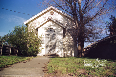
Built c.1868, St Andrew’s Anglican Church is Nillumbik Shire’s oldest timber church and is historically, socially, and spiritually significant to the Shire of Nillumbik. The church is historically significant because it may have given its name 'St Andrews' to the town (another suggestion is that the name came from the local hotel), it is also historically significant as one of only four buildings that remain from the Caledonian goldfields era of Queenstown (now St Andrews) and one of only a handful of buildings that survived the 1960s bushfires. The church is historically, socially, and spiritually significant because it has played an important part in community life for more than 150 years; a proposal to move the church in 1984 met with strenuous opposition. Much of the fires on Black Saturday 2009 were the north of the town. The town itself remained intact - as did this heritage building. Covered under Heritage Overlay, Nillumbik Planning Scheme. National Trust of Australia (Victoria) Local significance Published: Nillumbik Now and Then / Marguerite Marshall 2008; photographs Alan King with Marguerite Marshall.; p69 The St Andrews Anglican Church and former St Andrews Primary School, are two reminders of the district’s early days, when it was founded on gold. St Andrews, then called Queenstown, was the earliest goldfield in the Caledonia Diggings.1 It was the Upper Diamond Gold Mining and Administrative Centre, with 3000 miners. Queenstown was also the seat of the Court of Petty Sessions. The church and school then stood close to European and Chinese stores, three hotels, a brewery and a quartz mill.2 In 1861, Queenstown was officially proclaimed a township. From 1865, the name Queenstown was interchangeable with St Andrews, until 1952, when the town was officially named St Andrews. As gold declined from the early 1880s, Queenstown changed dramatically into a settlement of small farms. St Andrew’s Anglican Church, built in 1868, is the Shire’s oldest timber church and possibly gave its name to the township.3 The small timber church was opened on November 1, 1869, by the Dean of Melbourne. Anniversary tea meetings helped raise funds, and in 1889, a three-bedroom parsonage was built alongside. In 1910, the vicar, the Rev Selwyn Chase (and friend of the Scouting Movement’s founder, Baden Powell), established the 1st Queenstown Scout Troop, only two years after Scouting began in Australia. The church was important to the lives of many local residents who were baptised, married and had funeral services there. But by the 1950s the population had decreased and so did the weekly attendances. Around the mid-1960s the church closed, then fell into disrepair. So in the mid 1980s it was sold to the Education Department and was under threat of relocation or demolition. However this caused such opposition from locals,4 that instead, the Anglican church leased it as part of the Panton Hill parish5 and it was reconsecrated in 1987. Queenstown’s first school was held in a tent after transferring from Andersons Creek, Warrandyte.6 From 1858 a church school, Caledonia Diggings, stood west of the main road, a quarter of a mile (0.4km) before Buttermans Track. In 1882 the school was moved from a leased building, owned by headmaster Robert Harris, into a larger building on the corner of the School and the Heidelberg-Kinglake Roads. It had been moved from Smiths Gully and included a teacher’s three-roomed residence.7 In 1887 the school was replaced by the Queenstown State School No 128, although it was also called Caledonia Diggings until 1891. In 1956 it was renamed St Andrews. Still standing, this building is now used as the St Andrews Community Centre and the residence is leased for private use. The original timber-lined room remains alongside the extensions, and is distinctive with its high ceiling and tall small-paned windows. In 1984 a new school was built 500 metres west of the old school. Many residents have contributed much to St Andrews but one family that has done so for several generations is the Harris family. Robert Harris was an active member of the St Andrew’s Anglican Church, and worked hard at improving the town’s amenities until his death in 1887. He was a signatory to the successful 1863 petition to the Chief Commissioner of Police, against the proposed removal of the Court of Petty Sessions and police station at the Caledonia Diggings. The police station stayed in the town until 1917. Harris was Head Teacher of Queenstown State School from 1864 to 1874, then of the Smiths Gully school until it closed in 1882, and he continued teaching at Panton Hill until his death. His son, Robert Charles Harris, was editor and printer of the local newspaper, The Evelyn Observer, from 1873 until 1915. Robert’s son, William Shelley Harris, served in the Boer War and in World War One. In 1928 he became Kinglake National Park’s first park ranger. Robert’s daughter Elizabeth, taught needlework at Queenstown State School, and later ran the post office in Kinglake.This collection of almost 130 photos about places and people within the Shire of Nillumbik, an urban and rural municipality in Melbourne's north, contributes to an understanding of the history of the Shire. Published in 2008 immediately prior to the Black Saturday bushfires of February 7, 2009, it documents sites that were impacted, and in some cases destroyed by the fires. It includes photographs taken especially for the publication, creating a unique time capsule representing the Shire in the early 21st century. It remains the most recent comprehenesive publication devoted to the Shire's history connecting local residents to the past. nillumbik now and then (marshall-king) collection, st andrews, st andrews anglican church -
Mortlake and District Historical Society
Mt. Shadwell Bush Inn, photograph
This Mount Shadwell Bush Inn erected in 1854 was situated adjacent to one of the main routes to the diggings (Great Western Road), and was originally built from tufa stone obtained from a local quarry. It did a great trade after if first became licensed ub 1855, when it provided a valuable service to the travelling public and to the increasing agricultural population of the area. At that time it contained three sitting rooms, several large reception rooms, fourteen bedrooms, a bar and two taprooms and was the first known hostelry in Mortlake. In 1863 a bluestone addition (probably done by local architect Andrew Kerr) increased the size of the hotel to 23 rooms with a detached billiard room and ballroom, kitchen, servant's apartments, laundry, storeroom, 12 stalled stable, out office, and stock yards for travelling cattle. The present hotel with its 1928 rendered facade, has had an almost uninterrupted licence since 1855 -
 Bendigo Historical Society Inc.
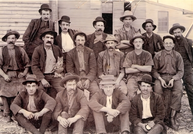
Slide - DIGGERS & MINING. THE DIGGING - THE DIGGERS, c1850s
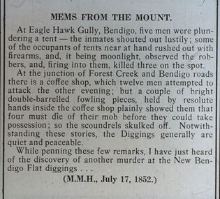
Diggers & Mining. The Digging - The Diggers. Slide; An article titled 'Mems From The Mount' At Eagle Hawk Gully, Bendigo, five men were plundering a tent - the inmates shouted out lustily; some of the occupants of tent near at hand rushed out with firearms, and it being moonlight, observed the robbers, and, firing into them, killed three on the spot. At the junction of Forest Creek and Bendigo roads there is a coffee shop, which twelve men attempted to attack the other evening; but a couple of bright double-barrelled fowling pieces, held by the resolute hands inside the coffee shop plainly showed them that possession; so the scoundrels skulled of. Not with-standing these stories, the Diggers generally are quiet and peaceable. While penning these few remarks, I have just heard of the discovery of another murder at the New Bendigo Flat Diggings. (M.M.H., July 17, 1852) Markings: -- 994.LIF:6. Used as a teaching aid.hanimounteducation, tertiary, goldfields -
 Bendigo Historical Society Inc.
Slide - DIGGERS & MINING. STORES AT THE DIGGINGS, c1850s
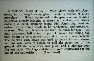
Diggers & Mining. Stores at the diggings. MONDAY, MARCH 29 - Went down with Mr. Armstrong into a neighbouring glen to make a seizure of a sly grog-shop . . . When we arrived at the grog shop we found a policeman already standing as sentry at the door and others, carbines in hand, standing round. Mr. Armstrong went in, ordered all he found inside to be handcuffed, and proceeded to search. The man, however had been too much for him - we only discovered half a keg of port. However the selling had been sworn to by a police spy, and so the tent was doomed. The culprit's own spade was used to knock his tent down, and his wife actually helped to pull the stakes out of the ground. All the woodwork was piled, and a glorious bonfire was made. The kegs and the tent were confiscated for the use of the authorities . . . (Continued) Markings: 33 994.LIF. 5. Used as a teaching aid.hanimounteducation, tertiary, goldfields -
 Eltham District Historical Society Inc
Negative - Photograph, Carl Walter 1831-1907, Coffer dam in the Yarra River at Anderson's Creek, 1864
1864 photograph of the Coffer Dam in the River Yarra situated (approximately) opposite Whipstick Gully. Remains of bridge built in 1860(?) wrecked by 1863 flood in background. Reproduced page 29 of ‘Pioneers & Painters’ Gold was first discovered in this area at Andersons Creek (Warrandyte) in June 1851 by Louis Michel. Discoveries north of the Yarra did not occur until about 1854. Although it took some months for a true rush to develop it was not long before alluvial workings were being carried on in most of the Shire of Eltham. The last area in which gold was discovered was Kinglake. As the gold became harder to find, deep mining took over from alluvial diggings in the gullies. Perhaps the most extensive of the deep workings was the Diamond Creek Mine just outside the boundary of the Shire. This form of mining was continued into the 1930s. There are believed to be some mines in the area still capable of producing gold but present prices make working these uneconomical. Some gold is still found by weekend prospectors. Photo: Carl Walter 1831-1907 – inscribed on tent “C. Walter Photo” The State Library of Victoria holds over 150 photos by Carl Walter, most of which are portraits of Aboriginal natives including William Barak.This photo forms part of a collection of photographs gathered by the Shire of Eltham for their centenary project book,"Pioneers and Painters: 100 years of the Shire of Eltham" by Alan Marshall (1971). The collection of over 500 images is held in partnership between Eltham District Historical Society and Yarra Plenty Regional Library (Eltham Library) and is now formally known as 'The Shire of Eltham Pioneers Photograph Collection.' It is significant in being the first community sourced collection representing the places and people of the Shire's first one hundred years.Digital image 4 x 5 inch B&W Neg (2) Print 20 x 25 cmshire of eltham pioneers photograph collection, anderson's creek, coffer dam, floods, gold mining, other areas, pioneers and painters, warrandyte, warrandyte bridge, yarra river -
 Ballarat Heritage Services
Photograph - Image, David Syme
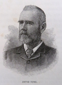
David Syme (1827-1908) was a newspaper proprietor who was born on 2 October 1827 at North Berwick, Scotland. Early in 1851, he went via Cape Horn to California seeking gold. By mid-1852 he was in Melbourne, and in the next three years prospected with some success on Ballarat, Bendigo, Castlemaine and Beechworth diggings. In 1855 he lost a possible fortune at Egerton near Ballarat when a promising claim was jumped. Ebenezer Syme bought the insolvent Melbourne Age for £2000, and invited David Syme to take up a share. In September 1856 Syme put up some cash and his contracting business to obtain a half-share. He helped to manage the paper but returned to contracting late in 1857. When Ebenezer retired in 1859 Syme reluctantly returned to the business, and on Ebenezer's death next year he began his fifty-year career as publisher and editor of the Age. (C. E. Sayers, 'Syme, David (1827–1908)', Australian Dictionary of Biography, National Centre of Biography, Australian National University, http://adb.anu.edu.au/biography/syme-david-4679/text7741, published first in hardcopy 1976, accessed online 25 August 2019._Reproducation of a image of David Syme.david syme, portrait, the age, journalist -
 Ballarat Heritage Services
Photograph - Image, David Syme, 1934
David Syme (1827-1908) was a newspaper proprietor who was born on 2 October 1827 at North Berwick, Scotland. Early in 1851, he went via Cape Horn to California seeking gold. By mid-1852 he was in Melbourne, and in the next three years prospected with some success on Ballarat, Bendigo, Castlemaine and Beechworth diggings. In 1855 he lost a possible fortune at Egerton near Ballarat when a promising claim was jumped. Ebenezer Syme bought the insolvent Melbourne Age for £2000, and invited David Syme to take up a share. In September 1856 Syme put up some cash and his contracting business to obtain a half-share. He helped to manage the paper but returned to contracting late in 1857. When Ebenezer retired in 1859 Syme reluctantly returned to the business, and on Ebenezer's death next year he began his fifty-year career as publisher and editor of the Age. (C. E. Sayers, 'Syme, David (1827–1908)', Australian Dictionary of Biography, National Centre of Biography, Australian National University, http://adb.anu.edu.au/biography/syme-david-4679/text7741, published first in hardcopy 1976, accessed online 25 August 2019._Reproducation of a image of David Syme.david syme, portrait, the age, journalist -
Federation University Historical Collection
Book, G. Quaife, Gold & Colonial Society: 1851-1870, 1975, 1975
Gold soft covered book gold, colonial, eureka stockade, diggings, earl grey, convicts, immigration, gold license, gold license fee, gold commission, police, law and order, james scobie, james bentley, catherine bentley, miners statistics, average earnings of miners, mining, quartz crushing, revenue, gold yields, state aid, irish, irish catholics -
 Bendigo Historical Society Inc.
Document - VICTORIA HILL - THE BENDIGO DIGGINGS, PRELIMINARY DRAFT FOR BROCHURE
BHS CollectionNine typed pages of notes on a preliminary draft for a brochure on the Bendigo Diggings. First part is the objective which is to preserve the mining history and to have exhibits in the places they were used, e.g. quartz mining machinery exhibited in a quartz mining area, not on an alluvial field. Part B is historical notes on the area. Part C is the Site - Victoria Hill area. Part D is Stage One which consists of carpark area, technological museum, restaurant, mineral haulage line, picnic ground, earthworks and planting over the area. Part E is Stage Two which will consist of the open-air exhibits, in the area surrounded by the mineral haulage line, and the Central Nell Gwynne mine on the west side of the site. Part F is Stage Three which will consist of the winery, the steam tram track, the lake, the wildlife sanctuary and various buildings associated with gold mining. Part G is Costing with the prices to be filled in. Parts H and I are the Appeal and the Committee. Details to be filled in. Notes prepared by Albert Richardson.mining, marketing, victoria hill, victoria hill, the bendigo diggings - preliminary draft for brochure, aust national travel association, tullamarine jetport, emu bottom homestead, kyneton historical museum, chinese joss house, eaglehawk museum, whipstick scrub, cairn curran reservoir, castelmaine historical museum and market hall, national trust, ballarat hiatorical park, echuca's hopwood gardens, swan hill folk museum, gibson's mount alexander no 2 squatting run, captain brown, chief commissioner wright, hustler's reef, thomas hustler, mining board, drainage of reefs act 1862, first world war, bendigo amalgamated goldfields, second world war, sandhurst, w c vahland, battery trams, horse trams, steam trams, electric trams, central nell gwynne mine, theodore ballerstadt, george lansell, new chum hill, ballerstadt's open cut, 180 mine, new chum syncline battery, william rae, victoria quartz, wittscheibe's 'jeweller's shop', luffsman and sterry, gold mines hotel, adventure, bendigo and district tourist association, bendigo city council, bendigo branch of the royal historical society of victoria, professor brian lewis, school of architecture and building at the university of melbourne, taylor horsfield, lord robert cecil, south australian gold commissioner -
 St Kilda Historical Society
Photograph, 22 November 1933
This school was one of the earliest in St Kilda. The 1842 plan of Crown Lands that were sold to establish what became the village of St Kilda reserved an area on Acland Street for the 'Church of England and School'. Christ Church was constructed on the site in 1854-57. A school had started before then but was closed for about a year after the Head Teacher abandoned his students in search of gold. A sign on the door read 'This school is closed in consequence of the master having gone to the diggings'. The school was re-opened in 1853, with only two pupils on the first day. The new Headmaster was John Hadfield, a teacher who had recently arrived in Melbourne from Wiltshire, England. He stayed on as Headmaster for the next 22 years. Free secular compulsory education was introduced in Victoria from 1873. Until a permanent State school could be built in the area, the Government used the St Kilda Town Hall for this purpose, and the students from Christ Church school were transferred there. The Brighton Road State School was opened in January 1875, with John Hadfield was its first Headmaster. The Government then leased the old Christ Church schoolroom and established a second school there. The Headmaster was James A Ure. The school continued until the 1940s. The building was burnt down in 1977.The building burnt down in 1977.black and white gloss photograph good condition unmountedFirst State School in St Kilda, Acland St, St Kilda 22 Nov 1933st kilda, christ church, acland street, st kilda schools, john hadfield, james a ure, christ church school, christ church college -
 St Kilda Historical Society
Photograph, c. 1865?
This school was one of the earliest in St Kilda. The 1842 plan of Crown Lands that were sold to establish what became the village of St Kilda reserved an area on Acland Street for the 'Church of England and School'. Christ Church was constructed on the site in 1854-57. A school had started before then but was closed for about a year after the Head Teacher abandoned his students in search of gold. A sign on the door read 'This school is closed in consequence of the master having gone to the diggings'. The school was re-opened in 1853, with only two pupils on the first day. The new Headmaster was John Hadfield, a teacher who had recently arrived in Melbourne from Wiltshire, England. He stayed on as Headmaster for the next 22 years. Free secular compulsory education was introduced in Victoria from 1873. Until a permanent State school could be built in the area, the Government used the St Kilda Town Hall for this purpose, and the students from Christ Church school were transferred there. The Brighton Road State School was opened in January 1875, with John Hadfield was its first Headmaster. The Government then leased the old Christ Church schoolroom and established a second school there. The Headmaster was James A Ure. The school continued until the 1940s. The building was burnt down in 1977.The building burnt down in 1977.Framed and mounted original photograph, black and white. First state school room in Victoria.st kilda, christ church, acland street, st kilda schools, john hadfield, james a ure, christ church school, christ church college -
Unions Ballarat
Journal of Australasian mining history 2007, Australian Mining History Association, 2007
Periodical/journal: "Embracing all aspects of mining history, mining archaeology and heritage." Articles by various contributors Copper Triangle’s Spanish Legacy: Leaching the Waste Dumps at Moonta Mines 1901-1944. Australian Geochemical Mineral Exploration: It all began at Moonta through V.P. Sokoloff. Hegemony, localism and ethnicity: The ‘Welsh’ mining communities of Currawang and Frogmore in southern New South Wales. A Thirsty and Confusing Diggings: The Albert Goldfield, Milparinka-Tibooburra, north-western NSW. ‘Another Broken Hill’: The Mount Deddick Silver-Lead Field. Michael Dineen O’Keeffe: Union Leader - a ‘colourful personality. Radium Hill: Bindi To Boom Town. Tragedy on the Strickland: Jack Hides and the Investors Ltd Expedition of 1937 COMMENTS Observations on the History of the Blackwater Gold Mine. Comment on Brian R. Hill, ‘A Reinterpretation of the History of the Acquisition of the Blackwater Gold Mine’, Journal of Australasian Mining History, vol. 4, September 2006, pp. 156-165. BOOK REVIEWS Bullfinch and the Yilgarn Goldfield, Hesperian Press, Victoria Park, Western Australia, 2007; xvi +265pp Reviewer: Lenore Layman, Murdoch University Fool’s Gold: Myths and Legends of Gold seeking in Australia, Lothian Books, Sydney, 2006. Reviewer: Philip Payton, Exeter University Relevant to Australian and New Zealand history, particularly around miners and mining.Paperback. Front cover: crème coloured background; black and white photo; red and black lettering; 180 pages.Front cover: title and publisher.btlc, ballarat trades and labour council, ballarat trades hall, history - mining, moonta mines, albert goldfield, milparinka-tibooburra, mount deddick, michael dineen o'keeffe, radium hill, strickland, investers ltd, blackwater gold mine, bullfinch, yilgam goldfield, gold -
 Eltham District Historical Society Inc
Photograph, Doug Orford, Eltham Courthouse, 730 Main Road, Eltham, 1985, 1985
This building is a fine example of a very early small brick country court house which retains its furnishings and has important associations with the early history of the Eltham township. It was used for Eltham Road Board meetings in the 1860s and later to provide additional school accommodation. It is the oldest public building remaining in Eltham and forms an important group in historic and streetscape terms with the adjoining former police residence. The survival of the furnishings (of unknown origins) is of particular significance given the building's age. This building, and the former police residence beside it, were constructed as a result of a petition by five Eltham residents in 1857. The nearest police were at Heidelberg eight miles away or at the Caledonia Diggings 21 miles away. After the construction of the Court of Petty Sessions at Eltham in 1859-60 (which was designed by the Public Works Department and built by a Mr Duncan for a cost of 536 pounds), it was used for a variety of purposes. Eltham Road Board meetings were held there until 1868 when the board was transferred to Kangaroo Ground and as the Road Board Secretary's office, until this was transferred to Wingrove Cottage in 1867. It was used as an overflow for the Dalton Street School in 1875. According to National Trust records, the Eltham Court House is a relatively rare building type. There are only six other known examples of similar small brick country court houses in the state which have small projecting entry porches and a gabled form. Roll of 35mm colour negative film, 7 stripsFuji 100Neltham, eltham courthouse, main road -
Eltham District Historical Society Inc
Folder, Ewen Cameron
Cameron, Ewen Hugh, M.L.A.., J.P. Kangaroo Ground, is a native of Inverness-shire, Scotland, and came out to Victoria in the ship Hurricane, 13th September, 1853. After he had been engaged for two years int eh building trade in Melbourne in company with is two brothers, since dead, he carried on storekeeping for several years at the Caledonia gold diggings. In 1860 he purchased 80 acres of land at Kangaroo Ground, where he now resides, and later 160 aces of lands at Yarra Flats; he has also 600 acres rented, and is occupied in grazing and agricultural pursuits generally. Mr Cameron holds the prize given by the agricultural society for the best-kept farm in the district. In 1863 he was elected a member of the shire council, and has held the position to represent the Castlemaine mining board, which office he still holds, and in 1874, he was elected to a seat in the Legislative Assembly for the County of Evelyn, which seat he still retains, having the contested the constituency five times, and been elected once without opposition. from "Victoria and its Metropolis: Past and Present" written in 1888 by Alexander Sutherland. Chapter 19, "The Upper Yarra District" pages [402] - 415. Includes descriptions of some townships and short biographies of local residents. Page 405 Folder of information on Ewen Hugh Cameron, MP, Kangaroo Groundewen cameron, pigeon bank -
Eltham District Historical Society Inc
Folder, J.D. and E. Cameron, 1850s
Cameron, Ewen Hugh, M.L.A.., J.P. Kangaroo Ground, is a native of Inverness-shire, Scotland, and came out to Victoria in the ship Hurricane, 13th September, 1853. After he had been engaged for two years int eh building trade in Melbourne in company with is two brothers, since dead, he carried on storekeeping for several years at the Caledonia gold diggings. In 1860 he purchased 80 acres of land at Kangaroo Ground, where he now resides, and later 160 aces of lands at Yarra Flats; he has also 600 acres rented, and is occupied in grazing and agricultural pursuits generally. Mr Cameron holds the prize given by the agricultural society for the best-kept farm in the district. In 1863 he was elected a member of the shire council, and has held the position to represent the Castlemaine mining board, which office he still holds, and in 1874, he was elected to a seat in the Legislative Assembly for the County of Evelyn, which seat he still retains, having the contested the constituency five times, and been elected once without opposition from "Victoria and its Metropolis: Past and Present" written in 1888 by Alexander Sutherland. Chapter 19, "The Upper Yarra District" pages [402] - 415. Includes descriptions of some townships and short biographies of local residents. Page 405 Folder of information on J D and E Cameron, land purchasers, Eltham, c.1850sj.d cameron -
 Orbost & District Historical Society
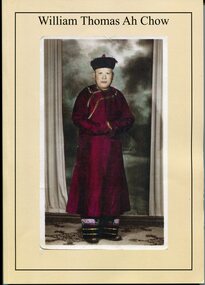
Booklet - Booklet, softcover, William Thomas Ah Chow, March 2019
This family history book was published as a family record of the Ah Chow family. A limited number of copies were printed. Thomas William (Bill) Ah Chow was a Chinese-Australian soldier, farmer, fire lookout and legendary bushman of East Gippsland in Victoria. Many Chinese came to the Victorian gold rush in the 1850s to seek their fortune at the Omeo and Cassilis diggings. Many of the immigrants later settled and integrated into their local communities working as farm labourers, tending market gardens, making furniture, running grocery stores and cafes or practising Chinese medicine. Thomas William "Bill" Ah Chow of Bruthen, Victoria attempted to enlist early in the War but was rejected for being "not substantially of European origin". Undeterred, he reapplied and was accepted in June 1917. During his service with the 5th Battalion, he was wounded at least three times. After the War, Bill returned to Bruthen where he drove sheep, worked cattle and eventually assisted in the building of roads through the area. He became a Forestry Commission fire-spotter and built a hut called 'Moscow Villa' in 1942. He lived in the hut during the summer months and in winter, returned to his family in Ensay. Whenever there was fire danger, he rode his horse up to the fire tower on Mt Nugong and acted as look-out. Bill worked for the Forestry Commission for more than twenty years and came out of retirement to continue his duties when no suitable replacement could be found. Bill died in 1967 and is buried in Omeo. Moscow Villa still stands and is a popular camping site This is a useful reference item. As a family history it is detailed and contains useful copies of personal documents. Bill Ah Chow, along with the Ah Chow family were well known in Orbost and East Gippsland. This booklet is a testament to his life. A soft covered 97pp book with a cream cover. On the front is a coloured photograph of a Chinese man in traditional robe and hat. On the back cover is Moscow Villa. It contains information, copies of 1949 photographs, documents, hand -written letters and a will. There is an envelope attached to the inside cover containing a CD, photos and family tree.ah-chow-william-thomas family-history-ah-chow -
 Bendigo Historical Society Inc.
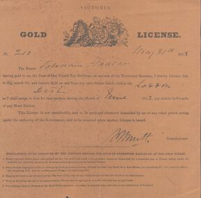
Document - MINER'S RIGHT - GOLD LICENSE NO 210 MINER'S RIGHT NO 20
Two licences, yellow-brown Victorian Gold License No 210, dated May 31, 1853 (a) and a Miner's Right No 20, dated 28 June 1861(b). The Gold License cost one pound ten shillings and for the month of June 1853. It was for Crown Lands within the Loddon District. At the bottom of the license are five Regulations to be observed by the person digging for gold or otherwise employed at the Gold Diggings. It has a crest at the top with a lion and a unicorn. Printed on a circular cnetre piece are the words: Honi so- -al y pense and below the lion, Dieu, in the centre is -t mon and under the unicorn is droit. The Miner's Right No 20, issued by the Colony of Victoria, for the District of Maldon, cost one pound. Across the top is a crest with a lion and a unicorn holding up an oval piece with a crown and a lion on top, In the oval is an illustration with two men and a woman and sailing ships in the background. Around the top of the oval is: Moni s- - qui mal y pense and at the bottom: Advance - Australia. Under the lion is: Dieu et mon and under the unicorn: Droit. Has been stamped in black, but is unreadable. Signatures and names on both documents are very hard to read. Printed by: John Ferres, Government Printer, Melbourne.document, gold, miner's right, miner's right, gold license no 210 & miner's right no20, john ferres -
 Puffing Billy Railway
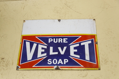
Sign - Advertising - Pure Velvet Soap - Enamel Sign, pre 1950s
Velvet Soap was a widely used laundry bar soap launched in 1906, produced by J. Kitchen & Sons, owned by John Ambrose Kitchen (1835 - 1922). Kitchen was born in Britain and emigrated to Victoria in 1854. After a less than successful period at the Caledonian and Blackwood diggings, Kitchen returned to Melbourne and joined his father and brothers in establishing a tallow candle making works. Through merger and expansion the company became the pre-eminent manufacturer of soap and candles in the eastern colonies in the mid to late 19th century. Kitchen also speculated in a number of enterprises but suffered financial setbacks as a result of the 1890s bank crashes. Despite this, the company continued to grow in the early twentieth century with the introduction of products such as Velvet Soap and Solvol. The company merged with the British company Lever Bros in 1914 who eventually took full control of the company in 1924, becoming Lever and Kitchen. Advertising for Velvet Soap in Australia was extensive and pervasive. All manner of surfaces were used to advertise the product such as building walls, roofs, and most commonly, enamelled sheet metal signs which were fastened to any available surface internally and externally. The most common form of sign that Velvet Soap used was the words 'PURE VELVET SOAP' in white lettering within a vivid dark blue, elongated Maltese cross. On the enamelled metal signs the Maltese cross sat on a red background with a yellow border. While this was the dominant form for Velvet Soap signs, there were variations from the standard. The Velvet Soap sign is of historical significance as a representative of painted signs that were once a common form of advertising during the nineteenth and early twentieth centuries. - : http://vhd.heritagecouncil.vic.gov.au/places/14447#sthash.Vb6KAUWl.dpufHistoric - Advertising Sign - Velvet SoapTin sign with white, yellow, red and blue enamel. Pure velvet soap.puffing billy, enamel sign, pure velvet soap -
 Bendigo Historical Society Inc.
Photograph - The Ruschmeyers - Publicans of the Town and Country Hotel, Diamond Hill Bendigo
John Christopher Ruschmeyer arrived in Melbourne aged 26 aboard the 'Essex' from Hanover, Germany via London in 1864. Shortly after his arrival in Australia he travelled to the Bendigo diggings. He became one of many thousands of German diggers on the Central Victorian Goldfields. He married Elizabeth Little Shepherd (Morrison) in 1874, a widow who had travelled down from Brisbane after the death of her first husband (John Shepherd). He became a naturalized citizen in 1893. Shortly after his marriage and having mined Golden Gully for some years he turned to hotel keeping and was the licensee of the Town and Country Hotel in Woodward Road, Golden Gully up until his death in 1911. The family of 4 daughters and 3 sons survived him. The family of Ernest, Maude, Christopher, Ethel and Edith (twins), Charles and Dolly Ruschmeyer all lived in the Bendigo area. His sons continued working in the mining tradition. He is buried with his wife in the Bendigo Cemetery. After his death Elizabeth moved to Thistle St until her death in 1922. Christopher Ruschmeyer and his family lived in a small house (now part of a poultry farm) in Woodwood road opposite the TOWN AND COUNTRY HOTEL. A brother Ernest Walter Ruschmeyer lived in a house next to the hotel. Ernest built the house. After Ernest's death in 1927 another brother Charles Hex Ruschmeyer married Ernest's wife Gertrude. The hotel was first licensed in 1898 and closed in 1916. John Ruschmeyer was the licensee until his death in 1911. Elizabeth took over the license until 1912 when it was sold to a Catherine E Hoffaer. This information is provided by Neil Graham of Strathfieldsaye whose Grandfather on his Mother's side was John Ruschmeyer and John Christopher Ruschmeyer was his Great Grandfather.Digital image: image shows Town and Country Hotel, Diamond Hill. Ruschmeyer's were the publicans. Standing outside hotel, were from left, Ethel, Dolly, Maude, Edith, Elizabeth.person, family, ruschmeyer, john christopher ruschmeyer, town and country hotel, ruschmeyer, diamond hill bendigo -
 Kew Historical Society Inc
Photograph, James Venn Morgan, c.1905
James Venn Morgan was known affectionately as ‘The Father of Kew’. Born in Somersetshire on February 21, 1823, he sailed to Australia in April, 1851. James V. Morgan, was a member of one of the first parties to leave for the diggings. At Chewton, near Castlemaine his party tried their luck in an abandoned shaft, and in two weeks returned to Melbourne after having won 35lb weight of gold. James Venn Morgan was content with his success, and induced his partners to invest their money with him in land. After obtaining the advice of a friend, the party negotiated with Mr Samuel Watts, of Collingwood, who had recently purchased land from the Crown, and from him they took over at £15 an acre about 32 acres of land in the district that is now known as Kew. This land extended from where the Kew Post-office now stands to the locality of the Boroondara Cemetery. Here it was that Mr Morgan decided to settle, and, after having had the land surveyed, the partners apportioned it by drawing straws for the four sections into which it had been divided. One of them sold his holding later in the year for £100 an acre, and was sorry for it afterwards. In 1853 Mr. Morgan built the first house in Kew, and this house is the one in which he still resides. Here with his wife, he settled down to market gardening and dairying. So successful was the new venture that he induced his father and other members of the family to come out to Australia to assist him. Gradually the district became settled, Mr. Morgan parted with a portion of his holding, and subdivided and built on the remainder, which he still retained. In 1884 he found himself in a position to retire from active business.He celebrated his 100th birthday in 1923. He was later to die in the same year. The Argus, 17 January 1923.Rare and historic hand-tinted framed portrait of one of the founding pioneers of the district.Hand tinted photograph in a gilt frame of the Kew pioneer James Venn Morgan (1823-1923).james venn morgan, kew - pioneer families, kew - landowners -
 Kew Historical Society Inc
Photograph, Anna Morgan, c. 1905
James Venn Morgan was known affectionately as ‘The Father of Kew’. Born in Somersetshire on February 21, 1823, he sailed to Australia in April, 1851. James V. Morgan, was a member of one of the first parties to leave for the diggings. At Chewton, near Castlemaine his party tried their luck in an abandoned shaft, and in two weeks returned to Melbourne after having won 35lb weight of gold. James Venn Morgan was content with his success, and induced his partners to invest their money with him in land. After obtaining the advice of a friend, the party negotiated with Mr Samuel Watts, of Collingwood, who had recently purchased land from the Crown, and from him they took over at £15 an acre about 32 acres of land in the district that is now known as Kew. This land extended from where the Kew Post-office now stands to the locality of the Boroondara Cemetery. Here it was that Mr Morgan decided to settle, and, after having had the land surveyed, the partners apportioned it by drawing straws for the four sections into which it had been divided. One of them sold his holding later in the year for £100 an acre, and was sorry for it afterwards. In 1853 Mr. Morgan built the first house in Kew, and this house is the one in which he still resides. Here with his wife, he settled down to market gardening and dairying. So successful was the new venture that he induced his father and other members of the family to come out to Australia to assist him. Gradually the district became settled, Mr. Morgan parted with a portion of his holding, and subdivided and built on the remainder, which he still retained. In 1884 he found himself in a position to retire from active business. He celebrated his 100th birthday in 1923. He was later to die in the same year. The Argus, 17 January 1923.Rare and-tinted framed photograph af Annie Morgan, the wife of one of the founding pioneers of the district.Hand tinted photograph in a gilt frame of Anna Morgan (nee Chidgey), the wife of James Venn Morgan. Anna Morgan was the wife of one of Kew's earliest pioneers and landowners. She died in 1915.anna morgan, kew - pioneers -
 Ballarat Heritage Services
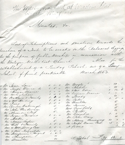
Document - Photocopy, First Names Wesleyan Ballarat 1853, 1853
A copy of a white piece of paper with creases photocopiedThis meeting was held at Winters' Flat below Magpie List of subscriptions and donations towards the purchase of a Tent to be erected on the Balaarat [sic] diggings, for the purposes of public worship in connexion with the Wesleyan Methodist Church. Also for the establishment of a Sunday School and of a Day School if found practicable. March 1853 Mr James Jones, Mr Joseph Wearne, Mr Thomas Wearne, Mr McCulchan, Mr Mathews and family, Mr & Mrs Harding, Mr Rees, Mr Charles Axborough, Mr John Henderson, Mr Alexander Ross, Mr Roger Parsons, Mr Baker, Mr Isaac Cooper, Mr Hill & family, Mr & Mrs Douglass, Mr & Mrs Reynolds, Mr Benjamin Sargent, Mr Thompson, Mr Dunstan, Mr Moyle, Mr Fletcher, Mr & Mrs Odie [sic], Mr William Wearne, Mr Brady, Mr Carter, Mr Moulton, Mr James, Mrs Crowfield, Mr Smith, Mr Crombie, Mr John Day, or Davy, Mr Adams, Buninyong, Mr Joseph Wearne, ?, A friendjames jones, mr joseph wearne, mr thomas wearne, mr mcculchan, mr mathews and family, mr & mrs harding, mr rees, mr charles axborough, mr john henderson, mr alexander ross, mr roger parsons, mr baker, mr isaac cooper, mr hill & family, mr & mrs douglass, mr & mrs reynolds, mr benjamin sargent, mr thompson, mr dunstan, mr moyle, mr fletcher, mr william wearne, mr brady, mr carter, mr moulton, mr james, mrs crowfield, mr smith, mr crombie, mr john day, or davy, mr adams, buninyong, oddie, mr and mrs oddie -
 Halls Gap & Grampians Historical Society
Map - Coloured
Background on Bridle Path up Stony Creek Gorge Pre 1840 C. B. Hall, squatter on Mokepilly Run 1841-1842, first European to discover the Fyans Creek valley, the entrance of which became known as Hall's Gap. He later recorded that he followed a number of tracks which he assumed had been made by the Aboriginies and described one as "leading up a wild romantic glen and over on to the source of the Glenelg River". This could well have been the route taken up Stony Creek gorge by the first timber-cutters in this part of the Grampians to the saddle between the Wonderland and Mt. Difficult ranges known as Valley Gap 1850s/60s Timber cutters and shingle splitters were reported to be moving into the eastern side of the Grampians and by the mid 1860s there were a number of families connected to the supplying of timber to Pleasant Creek living in the "Hall's Gap ranges". John Wakeham, the first store owner in Pleasant Creek in 1854, established a timer-mill in upper Stony Creek Gorge in the late 1850s. Wakeham is credited for the clearing and levelling of the first bridle-path up the gorge. 1870s By the mid 1870s the track had been extended over Valley Gap to the Victoria Forest (the upper region of the Victoria Valley). McKeon's bullock team was known to have hauled red gum from the Valley to Stawell in the late 1870s and the 1880s. 1880s In 1887 an article in the Pleasant Creek news describes the Stony Creek Gorge track as "being a ledge alongside the mountain range, formed in the early days with the aid of earth and timber, along which the bullock teams used to travel to Horsham and plains of the Wimmera beyond." 1890s Gold was discovered in the catchment area of Stony Creek and by the end of the 1890s a new track was built from "near the junction of Fyan's and Stony Creeks, up the gorge to the diggings settlement. The mining Department had paid L300 for its construction and, when completed, the track was "three miles and 30 chains in length, the side cuttings at the narrowest part being 10 feet between" and "the watercourses which cross the track at various points" having been "filled up with rocks rolled down the sides of the hills, and consequently there can be no damage caused by bushfires which destroyed the former wooden bridges erected on the old track to Wakeham's saw-mill, the remains of which are still to be seen at the side of the diggings" The article goes on to further describe the track as one which "can with ease travel with a two horse conveyance either up or down" and that the workmen engaged in the construction of the track would be attending "a ball that night at McKeon's farm near the mouth of the gap to celebrate the successful completion of the undertaking". 1900s At what time the bridle path was extended beyond Valley Gap to the Wartook basin on the Mt. Difficult Range has not yet been determined. However, it is known that, by the turn of the century, people were travelling between Halls Gap and the caretakers' residence at Wartook Reservoir along what was now known as the "Bluff Road. Wartook's embankment had been constructed in 1887 and at that time there was already a track from Rosebrook Station homestead (near the present day Wartook Pottery) to the reservoir. Philip Rose owned both Rosebrook and Wartook Stations from the mid 1840s to the late 1850s and had regularly leased the Wartook basin to Cobb & Co. to rest horses there. 1920s Following the war of 1914-1918, tourism really took off in the Grampians, and Halls Gap rapidly grew. People would travel as far as they could on the many tracks then hike to the many lookouts being discovered by local tour guides. This led to the need for access across the range so that horse riders and the increasing number of vehicles could travel between Horsham and Halls Gap. To this end, the Bluff Road was improved and extended on 1929 and at its opening in March, 1930, by Lady Somers it was renamed the Mt. Victory Road.Map of Mt Victory Road and othersaccess routes, mt victory rd, bridle path, roads -
 Eltham District Historical Society Inc
Photograph - Digital Photograph, Alan King, Kinglake National Park, 27 March 2008
Fern gullies around Jehosaphat Gully Covered under National Estate. Published: Nillumbik Now and Then / Marguerite Marshall 2008; photographs Alan King with Marguerite Marshall.; p125 The magnificent Kinglake National Park, fringing Nillumbik’s north, is the largest national park close to Melbourne. Thanks to the vision and hard work of a band of local people, the park was created from what was rapidly becoming degraded land. Seeing a threat to Kinglake’s indigenous flora and fauna, several prominent local people campaigned for a national park, which was established in 1928.1 Since then, the park has grown through donations and acquisitions of land, from around 13,800 acres of land (5585ha) to 22,360 hectares. The Sugarloaf and Everard Blocks – of almost 8000 hectares – stand in Nillumbik and the park extends into Mitchell and Murrundindi Shires and the City of Whittlesea. Mt Everard commemorates William Hugh Everard, State member for Evelyn when the park was established. Before 1928, European settlers had degraded the Kinglake area, which was named after the celebrated English author and lawyer, Alexander William Kinglake. Remains of gold shafts and diggings in the park are reminders of Kinglake’s first settlers, who hoped to strike it rich at the gold diggings. But like other gold fields in this shire, they proved not very lucrative and soon timber cutting replaced mining in importance. However, before long, the accessible timber supply ran out, so in the 1920s agriculture took over – particularly potatoes and berry fruits – which involved large-scale clearing.2 The park’s instigator was retired Melbourne University Professor of Music, William Laver.3 As chair of the Kinglake Progress Association he began negotiations to have crown lands on the southern scarp of the Great Dividing Range reserved as a national park. Even before the park was proclaimed, from 1927, KPA members cut tracks to the major scenic points. Professor Laver was one of several people who gave land for the park, donating around 50 acres (20ha), including the Jehosaphat Gully.4 Laver chaired the park’s first Committee of Management, which raised money to employ a ranger and provide facilities, including tracks and roads for fire protection vehicles, toilets and shelters. The committee charged fees for firewood collection, some grazing of livestock, and visitor entrance, and obtained small State Government and Eltham Shire grants. In 1957 the State Government provided revenue for national parks. Then, in 1975, the State Government took over the management and the Committee of Management became an advisory committee, which disbanded in 1978. Originally, the park covered crown land in the Shires of Eltham and Whittlesea; then Wombelano Falls in Yea and other areas were added. In 1970 the park extended into the Shires of Eltham, Healesville, Whittlesea and Yea.5 Bush fires have been an ongoing problem. In 1939 hundreds of eucalypts and acacias had to be sown around the Jehosaphat Gully to rejuvenate the forest. To manage bushfires, the Committee of Management, then the State Government, worked closely with the Forestry Commission, shire councils and local fire brigades. Early national parks focussed on recreation. But by the 1980s, conservation, education and scientific research became more important, playing a vital role in preserving representative samples of the natural environment. Each year many thousands of people use the park’s extensive network of walking tracks amongst the protected plant and animal life as well as camping, cycling and horse riding. The park, along the slopes of the Great Dividing Range, has lookouts revealing magnificent views of the Melbourne skyline, Port Phillip Bay, the Yarra Valley and the You Yangs. Vegetation in the Masons Falls area includes messmate forest, Austral grass-trees, ferns and Hazel Pomaderris. In spring, orchids, lilies, everlasting daisies, correas, grevillea and heath appear. Around Jehosaphat Gully are wet and dry forest, fern gullies and banksia. Animal life includes wallabies, kangaroos, koalas, echidnas, possums, gliders and bandicoots. Male lyrebirds can be heard mimicking in the Jehosaphat Gully, particularly in the Everard Block in winter.This collection of almost 130 photos about places and people within the Shire of Nillumbik, an urban and rural municipality in Melbourne's north, contributes to an understanding of the history of the Shire. Published in 2008 immediately prior to the Black Saturday bushfires of February 7, 2009, it documents sites that were impacted, and in some cases destroyed by the fires. It includes photographs taken especially for the publication, creating a unique time capsule representing the Shire in the early 21st century. It remains the most recent comprehenesive publication devoted to the Shire's history connecting local residents to the past. nillumbik now and then (marshall-king) collection, kinglake national park, jehosaphat gully -
Federation University Historical Collection
Pamphlet, Jeff Zilles, Old Curiosity Shop, c1980s
The Old Curiosity Shop was q house was built by bricklayer James Warwick, and his wife Caroline, with construction beginning around 1863. It was opened to the public in 1895. What is significant? Construction of the house later known as the Old Curiosity Shop commenced about 1863, the year bricklayer, James Warwick obtained a miner's right for a residential block on the edge of the exhausted Eureka diggings in the newly proclaimed municipality of Ballarat East. James built a modest 4-roomed timber and brick house for his expanding family and continued in the bricklaying trade until retiring around the early 1880s. By then he was pursuing his gardening interests in the local Horticultural Society and was supervising the gardens of many East Ballarat residents. It was during these years that his gardening and building interests converged to find expression in the marvellous permutations of decoration that extend over the house and garden. Using cast-off crockery, glass, ceramic figurine and mirror shards, shells, wallpaper samples, architectural ornament and slag, a place was found for all manner of things, large and small. Children would bring broken china dolls and bits of crockery, and the patient mosaic work preoccupied James and his wife Caroline for the rest of their lives. The work has its origins in the grottoes and shellhouses that ornamented the gardens of large English estates from the 1730s. In the few years before James' death in 1898, the house had become known as the 'Old Curiosity Shop', inspiring associations with the Charles Dickens novel of the same name. By then professional photographs had also been taken and thousands of tourists were visiting it yearly. Caroline obtained copyright for 2 of the photos and began issuing her own postcards before she died in 1903. The Shop passed to their son Charles and then to a succession of owners who added their own mythology to the story of the Warwicks and their work. After attracting tourists for more than 100 years, the Shop closed to the public in 1999. (Vitorian Heritage Database)Brochures on the Old Curiosity Shopold curiosity shop, warwick, ballarat east, james warwick, caroline warwick -
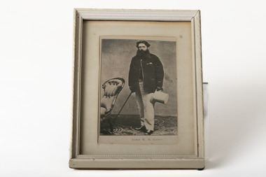 Chiltern Athenaeum Trust
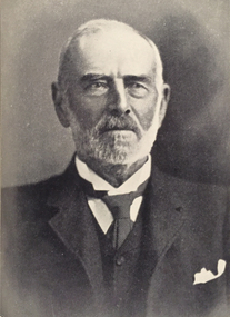
Photograph, JUDGE W. H. GAUNT
This photograph is a copy displayed in the Australian Dictionary of Biography. The original photograph is in the La Trobe Collection in the State Library of Victoria. William Henry Gaunt (1830-1905), judge, was born on 27 July 1830 at Leek, Staffordshire, England, son of John Gaunt, banker, and his wife Mary, née Bakewell. Educated at Leek Grammar School and Whitchurch, Salop, he migrated to Melbourne, and entered the Victorian public service and was rapidly promoted. By March 1854 he was chief clerk at Beechworth, the administrative centre of the Ovens goldfield. In July 1855 the resident warden commended Gaunt as 'a highly valuable public servant' with an intimate knowledge of the district and the 'temper and disposition of the miners'. Appointed sub-warden in the Beechworth district in January 1856 and a Chinese protector in August, he was given control of the extensive Woolshed district. When European miners attacked a party of Chinese at the Buckland River diggings in May 1857 Gaunt was sent to restore order. One of his proclamations, issued in Chinese characters, concluded 'W. H. Gaunt, your protector—tremble and obey!' In June he was appointed a police magistrate and next month was sent to take charge at the Buckland where the Chinese had been expelled from the diggings; the police force assisting him was led by Robert O'Hara Burke. In January 1858 Gaunt was appointed a warden, in November was transferred to Chiltern, north of Beechworth, and in August 1859 was made a commissioner of crown lands. In February 1860 Gaunt was appointed a coroner of Victoria, acting at Indigo, near Chiltern. In April 1865 he was transferred to Beechworth, became visiting justice of the gaol and later moved to Sandhurst. In January 1869 he was appointed returning officer for the mining district of Ballarat and visiting justice of the gaol. He was associated with this area for the rest of his life and won high repute for his integrity. In 1874 he chaired the inaugural meeting of the first Australian competitive swimming club. For years he studied law and was called to the Bar in December 1873. He was one of the many public servants dismissed by Graham Berry on 9 January 1878 (Black Wednesday). After petitioning the Queen in vain over his dismissal he began practice in Ballarat as a barrister. He soon became a leading authority on mining laws; one of the cases in which he was involved was the lengthy inquest on the bodies of the twenty-two miners drowned in the New Australasian mine disaster at Creswick in 1882. He was appointed a temporary judge of the Insolvency Court in 1889 and a County Court judge in 1891. In 1900 he was chairman of the royal commission which considered Metropolitan Board of Works matters, and in 1902 was president of the inquiry into the unification of municipalities in Victoria. In 1860 Gaunt married Elizabeth Mary, the youngest daughter of Frederick Palmer; they had nine children. Of the surviving five sons and two daughters, Ernest Frederick Augustus and Guy Reginald Archer both became admirals and were knighted; Cecil Robert became a lieutenant-colonel, Clive Herbert a government advocate in Rangoon and Mary (Mrs H. L. Miller) one of the first women students to enrol at the University of Melbourne (1881), although she did not complete her degree; she became a successful novelist. Gaunt died on 5 October 1905. An anonymous colleague said: 'I don't think he was ever excelled as a police magistrate, and during the many years he was on the County Court bench he earned the highest regard. His capacities were as unquestioned as his integrity, and more could not be said of any judge'. Select Bibliography Votes and Proceedings (Legislative Assembly, Victoria), 1878, 3, (58) Government Gazette (Victoria), 22 Feb, 15 Aug 1856, 30 June 1857, 5 Jan 1858, 16 Aug 1859, 3 Feb 1860, 7 Mar, 11 Oct 1862, 28 Mar, 4 Apr 1865, 17 May 1867, 9 June 1868, 22, 29 Jan 1869 Ovens and Murray Advertiser, 21 May 1857, 11 Mar 1865 Colonial Secretary's in-letters, goldfields, 25 Mar 1854, 21 July, 18 Nov 1855, 22 Aug 1857 (Public Record Office Victoria) scrapbook and newsclippings (privately held). Related Entries in NCB Sitesview family tree Gaunt, Mary Eliza (daughter)go to ADB entryPhotograph of Judge W. H. Gaunt standing beside chair holding top hat and cane, under glass, in cream frame with cream matte.Printed name underneath: JUDGE W. H. GAUNT -
Ringwood and District Historical Society
Biography, He heard Dickens, Disraeli, 21-Jul-44
Handwritten article about Captain Edward Thomas Miles 21-Jul-1944, copied from a newspaper.This is a handwritten copy from an unnamed newspaper. Refer also to the Australian Dictionary of Biography.; 21-Jul-1944 - Newspaper.; He heard Dickens, Disraeli; Captain Edward Thomas Miles who died recently at Ringwood where he had lived in retirement for many years, was born in Hobart 1849 and gained Master Mariners Certificate at 21 and his first command two years later. Served in the China, South African and Indian Wars. Was on the China - London tea run.; Pioneered the coastal trade of Tasmania.; was warden of Hobart marine Board, Member for Glamorgan in the Tasmanian House of Assembly for 12 years and also a minister before Federation.; In 1905 got Concession from Siam to form the Tongkah Harbour Tin Dredging Company, which later won 2,000,000 pounds worth of Tin. Sons and Grandsons managed the original company until present war, and one son and three grandsons remained to become prisioners of war.; Met Cecil Rhodes when he went to the Cape with his first sample of diamonds from the Kimberley.; With all other ship's officers was called out as special policeman to quell the Fenian riots in London.; Heard on several occasions Charles Dickens reading his own works. Listened to Disraeli and Gladstone speaking in the House of Commons.; With his partners built the Zeehan to Strahan railway, Tasmania, 29 miles. Was shipwrecked 3 times.; His first memory was that of travelling with his parents to the gold diggings in Victoria by bullock cart in 1852 at the age of three years. +Additional Keywords: Miles, Captain Edward Thomas / Dickens, Charles / Disraeli / Rhodes / Gladstone