Showing 54548 items
matching gold-mining-east-gippsland
-
 Lakes Entrance Regional Historical Society (operating as Lakes Entrance History Centre & Museum)
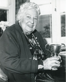
Photograph, East Gippsland Newspaper, 1989
Black and white photograph of Mrs Vi Symmons nee Coate taken during an interview with local newspaper reporter prior to her 88th birthday, Lakes Entrance Victoriacelebrations, genealogy -
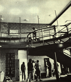
 Federation University Historical Collection
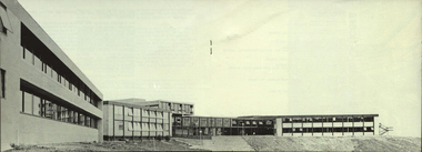
Photograph, Gippsland Institute of Advanced Education Ampitheatre, c1976
The Gippsland Institute of Advanced Education was established by an Order-in-Council in September 1968. The Council of the Institute included members of the Gippsland community who are prominent in local government, industry, commerce, education and the professions, the Director of the Institute, and representatives of the academic staff, students, and graduates. On its establishment, the institute assumed responsibility for the diploma courses previously offered by the Yallourn Technical College which had commenced diploma teaching in 1929. Initially, all the Institute's teaching was conducted in the diploma building of the Yallourn Technical College. In 1972 the Institute transferred part of its operations to the first of its permanent buildings on a large campus in rural surrounds near the township of Churchill, ten kilometres south of MOrwell and one hundred and sixty kilometres east of Melbourne. The Gippsland Institute of Advanced Education was opened on 20 November 1976 by the Honourable Lindsay Thompson, Deputy Premier of Victoria and Minister of Education; and Senator J.L. Carrick, Minister for Education in the Commonwealth Government. The Gippsland Institute of Advanced Education ampitheatregippsland institute of advanced education, gippsland campus collection, churchill, ampitheatre, buildings -
 Buninyong Visitor Information Centre
Ceremonial object - Sash, Buninyong Gold King Festival 1991
Purple sash with gold writing used in the 1991 Buninyong Gold King Festival. The festival was an annual celebration that included a procession through the centre of the town. Possibly used as a prize. Long strip of purple satin-like fabric with gold printing on it. Gold coloured fringes on each end. Buninyong Gold King Festival 1991festivals, celebrations, prizes -
 National Vietnam Veterans Museum (NVVM)
Journal, VVAA West Gippsland Sub-Branch
veterans – australia – periodicals -
National Vietnam Veterans Museum (NVVM)
Photograph, West Gippsland Vietnam Veterans ACCO Truck Restoration Project
Photo album of photos. Also contains 2 USB sticks of the photos in the album.west gippsland vietnam veterans, acco truck restoration project -
 Federation University Historical Collection
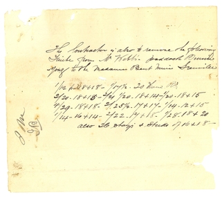
Document, Contract for the Madame Bent Gold Mining Company, 1886, 1886
Handwritten on foolscap paper, with red seal on last page.1) The Subcontractor is also to remove the following [ ? ] from Mr Webb's paddock ... to the Madame Bent Mine Grenville ... .2) Specification for the taking doan, removal and reerection 2 Engines 2 boilers pumping gear, Bob, Poppett heads and Capstone etc, for teh Mdame Bent G.M.Cy Grenville. The company will provide ... .3) Morey's Coys yard, together with holding down bolts, and the following ... .4) to the extent of Bed ... Carpentry Work - To carefully take down the poppet heads and co... and erect the same on the claim complete ... .5) Engine Framing as shown for the winding engines and pumping engines. Properly fitted to get ... .6) The boilers to be fed in front. The contractor to cut and drill all necessary holes in the boilers and pipes - to fire blow ... The contractor to make good any damage or breakage or loss to machinery or any part hereof that may occur to it during the removal of the reerection of same. The loss or damage, if any, not being made good by the contractor, or in the event of the works not being proceeded with to the satisfaction of the Company;s Engineer, The company's Engineer hereby ... .7) of the whole of the works, and in default thereof the COntractor shall forfeit the sum of two pounds ... Signed James Malcolm Witness L. Menz The Common seal of the company was affixed this thirteenth day of December:/86 by its manager James Burrell in the presence of [illegible] managers Seal - Madame Bent Gold Mining Company Durham Lead Buninyongmadame bent gold mining company, richard squire, james malcolm, james burrell -
Lakes Entrance Regional Historical Society (operating as Lakes Entrance History Centre & Museum)
Album - Photograph, LERHS members, 2010 c
Small album of colour photographs taken in areas of East Gippsland and of trips to Bruthen and Sale, East Gippsland Victoriaworld war 1914-1918, world war 1939 - 1945, military history -
 Orbost & District Historical Society
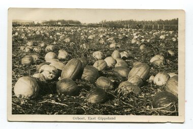
black and white photograph / postcard, first half 20th century
Pumpkins were grown widely on Orbost farms and used to feed pigsThis photograph is associated with pumpkin growing in Orbost.A black / white photograph / postcard of a paddock of pumpkins.on front- at bottom - "Orbost, East Gippsland"orbost-agriculture pumpkins-orbost -
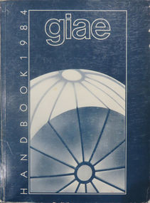 Federation University Historical Collection
Book, Gippsland Institute of Advanced Education Handbooks, 1970-1985
.1) 1977 Gippsland Institute of Advanced Education Handbook with white cover .2) 1978 Gippsland Institute of Advanced Education Handbook with blue/black cover .3) 1979 Gippsland Institute of Advanced Education Handbook with orange cover .4) 1980 Gippsland Institute of Advanced Education Handbook with yellow/brown cover .5) 1981 Gippsland Institute of Advanced Education Handbook with grey/black cover .6 1984 Gippsland Institute of Advanced Education Handbook with blue cover .7) 1985 Gippsland Institute of Advanced Education Handbook with purple cover .8) 1989 Gippsland Institute of Advanced Education Handbook with white/purple/grey/red/blue cover .7) 1985 Gippsland Institute of Advanced Education Handbook with pale green cover. .9) 1974 Gippsland Institute of Advanced Education Handbook with orangeand white cover .10) 1975 Gippsland Institute of Advanced Education Handbook with green and white cover .11) 1976 Gippsland Institute of Advanced Education Handbook with white cover .12) 1986 Gippsland Institute of Advanced Education Handbook with mid-blue cover .13) 1987 Gippsland Institute of Advanced Education Handbook with red cover .14) 1988 Gippsland Institute of Advanced Education Handbook with red cover .15) 1973 Gippsland Institute of Advanced Education Handbook with brown cover .16) 1972 Gippsland Institute of Advanced Education Handbook with pale green cover .17) 1971 Gippsland Institute of Advanced Education Handbook with mid-blue cover non-fictiongippsland institute of advanced education, giae, gippsland, churchill, morwell, electricty, handbook, gippsland campus -
Lakes Entrance Regional Historical Society (operating as Lakes Entrance History Centre & Museum)
Book, North East Regional Tourist Authority, North East Victoria, 1980
A brief record of the region from the Murray River in the north to the Dargo High Plains in the south, from Yarrawonga and Wangaratta in the west to the Indi River in the east. Illustrated with coloured photographs.tourism, mines and mining, settlers, water supply -
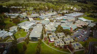 Federation University Historical Collection
Photograph, Aerial View of Gippsland Campus, 07/06/2017
In 1989 Monash University took over the Gippsland Institute of Advanced Education to create Monash Gippsland Campus. In 2014 the University of Ballarat and the Churchill Campus of Monash University merged to become Federation University Australia.Photograph of the Federation University Gippsland Campuschurchill, aerial, gipps, gippsland campus -
 Stawell Historical Society Inc
Photograph, Stawell Gold Mine
Gold MiningStawell Gold Mines at night -
Ringwood and District Historical Society
Report, Ringwood East Primary School, Ringwood East Primary School Parents Club: Documents re Toilet Facilities 1970's, 1970s
2 typed pages for Ringwood East Primary School No.4180 about toilet facilities; See also Box 01-03-02 Box 1 working committee papers. -
Lakes Entrance Regional Historical Society (operating as Lakes Entrance History Centre & Museum)
Book, Burt, Jocelyn, Discovering Gippsland, 1985
Photographs and text highlighting the natural beauty of Gippsland, Victoria.topography, township, parks -
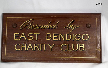 Bendigo Military Museum
Plaque - EAST BENDIGO PLAQUE
This belonged to East Bendigo Honour Board WW2 held at this museum. Not yet catalogued.A varnished wooden plaque. It has gold painted lettering with dark printed shadow effect. It has curved edging. It is rectangular shaped.“Presented by East Bendigo Charity Club”war, east bendigo, honour boards -
Ringwood and District Historical Society
Administrative record - Mining Reports, Government Printer, Melbourne, Colony of Victoria quarterly and annual mining reports - 1860s 1870s & 1880s, 1865 - 1883
Colony of Victoria mining reports show any Ringwood mine references under Castlemaine District, St. Andrews Subdivision. Noteworthy for Ringwood: - Death of Pierce Boardman, mining manager at New Ringwood Mining Co., accidentally killed when he lost his footing and fell to a depth of 40 feet on 1st January 1879. - William White injured in truck accident at New Ringwood Antimony Tribute Company, 31st March 1882.Boxed collection of soft and hard bound reports including: 1. Quarterly Colony of Victoria reports of the Mining Surveyors & Registrars, Victoria, 1865-1881 - Summary of gold mining statistics for the quarter - Tables showing the yield of gold from certain parcels of quartz raised during the quarter in some of the deepest mines in Victoria with depth of the deepest shafts, levels, cross-cuts, etc. - Estimated yield of gold and quantity of gold exported during the quarter - Gold received and issued from the Royal Mint during the quarter - Summary of yield of gold from quartz, tailings, etc., crushed during the quarter - Summary of yield of gold from washdirt and cement washed and crushed during quarter - Number and distribution of miners on the goldfields of the colony. 2. 1879-82 Hard bound volume - Chief Inspector of Mines Reports to the Honorable Minister of Mines, Victoria. (Includes fatal and non-fatal accident reports, mining operations, and employment statistcs.) Noteworthy for Ringwood: - Death of Pierce Boardman, mining manager at New Ringwood Mining Co., accidentally killed when he lost his footing and fell to a depth of 40 feet on 1st January 1879. - William White injured in truck accident at New Ringwood Antimony Tribute Company, 31st March 1882. 3. Mineral Statistics for Victoria - annual reports for years 1867, 1871, 1874, 1876, 1877, 1878, & 1879. 4. Handwritten study notes.antimony, boardman, william white -
Stawell Historical Society Inc
Photograph, Sister Rocks Looking East, 12011
Looking East Same view as eariler Photograph 0022-39 Colour Photgraph of Sister Rocks Looking EastLooking East 2011tourism -
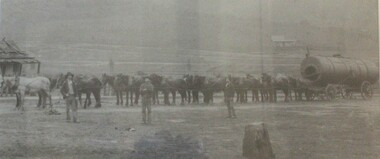 Wodonga & District Historical Society Inc
Photograph - North-Eastern Gold Days, 1900
Bethanga was established as a result of the discovery of gold. Gold was first reported in the Bethanga area in 1852. Before 1876 gold mining in the Bethanga district occurred to the north of the town and was known as the 'Talgarno diggings'. Reports of alluvial gold date back to 1852. Early gold fields were worked at Ruby Creek, Gold Creek and Jarvis Creek. The opening of the Bethanga goldfields began with the discovery of a gold-bearing quartz reef on New Year’s Day 1876. The 'Gift' mine site is located southeast of Kurrajong Gap lookout to the west of Bethanga township. The Great Eastern Copper Smelting Works was opened in 1878. Due to the nature of the gold-bearing quartz reef, the gold was difficult to extract, and the discovery of copper led to a change in focus. It was not until the early 1890s that an efficient technique for extracting the gold from the ore was discovered, and once again gold became the focus, with copper as a by-product. Bethanga was removed from the official list of goldfields in 1912, however some mining activity has taken place since.This image reflects an important time in the development of Bethanga and Northeast Victoria.A large mounted and framed image of horse teams and their owners hauling a large boiler to the gold mine near Bethanga, Victoria. On label beneath image: "North-eastern "Gold Days"/ Combined teams hauling a boiler to Bethanga Mines, 1900. Teamsters - Mr. G. Pearce, W. Chapple, G, Bannon." Donated by Ron Saunders and Barbara Cadman"bethanga, gold mining northeast victoria, gold mining bethanga, bethanga history -
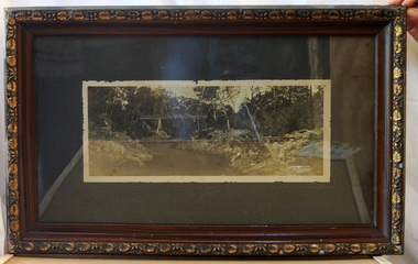 Orbost & District Historical Society
framed black and white photograph, C1920
Boggy Creek Bridge was built in 1916 as part of the Bairnsdale to Orbost extension to the main Gippsland Railway, and is situated in the middle of the township of Nowa Nowa, crossing a steep-sided and well-timbered creek-valley. This section of the line closed in 1987. This item is a pictorial record of the Boggy Creek railway bridge on the East Gippsland line. This bridge plays a major part in the identity and history of the town of Nowa Nowa, since Boggy Creek’s steep sided valley divides the township into two components.A black / white photograph of a bridge across a river in the bush. It is under glass in a brown wooden frame which has gold decorated edges. There appears to be a man sitting on rocks in the right front foreground.on front of photograph - "Nowa Nowa Creek, Gippsland, Victoria, Sears, Copyright"boggy-creek-nowa-nowa east-gippsland-railway bridge-rail -
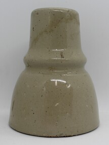 Ringwood and District Historical Society
Ceramic - Insulators, Insulator factory in East Ringwood, Three ceramic insulators made in East Ringwood from local clay - c.1900, c. 1900
The insulator factory and ovens were located on the SW corner of Velma Grove and Mount Dandenong Road approx. Quarrying for clay was done in the nearby area. Refer photographs of the factory.Two ceramic insulators made in East Ringwood from local clay. Colour grey. Conical with indentation in middle for wires. There is a second 'skirt' inside to enhance insulating performance. The inner hole is threaded. -
Ringwood and District Historical Society
Magazines, Ringwood East Primary School students, Ringwood East Primary School magazines. C1980-1990s, c.1980-1990s
7 school magazines hand written in many places with drawings by the pupils including stories and poems, made between 1980s and 1992.7 typed and handwritten copies of Ringwood East Primary School magazines between 1985-1992; loose pages held together by paper clips. 4 blue 2 yellow front pages. -
Lakes Entrance Regional Historical Society (operating as Lakes Entrance History Centre & Museum)
Book, Paul Kelly & Associates, East Gippsland Community Wellbeing Plan 2005-2008, 2003
Code of practice detailing minimum acceptable standards of work on land managed , works includes construction works regular maintenance contractors and provision of services East Gippland Victoriavegetation, fire brigade -
Lakes Entrance Regional Historical Society (operating as Lakes Entrance History Centre & Museum)
Album, 1990 c
A4 album of twelve black and white photographs taken during East Gippsland Bullock League activities in East Gippsland Victoriatownship, volunteering -
Stawell Historical Society Inc
Archive, Botanic Mining Co. No Liability Stawell. Share Register, 10/10/1896
Cover Heavy Card. Spine Leather. Inscriptions in GoldShare Register Botanic Mining Co. No Liability stawell -
 Federation University Historical Collection
Photograph, The Knuckle at Gippsland Institute of Advanced Education, c1976
The Gippsland Institute of Advanced Education was established by an Order-in-Council in September 1968. The Council of the Institute included members of the Gippsland community who are prominent in local government, industry, commerce, education and the professions, the Director of the Institute, and representatives of the academic staff, students, and graduates. On its establishment, the institute assumed responsibility for the diploma courses previously offered by the Yallourn Technical College which had commenced diploma teaching in 1929. Initially, all the Institute's teaching was conducted in the diploma building of the Yallourn Technical College. In 1972 the Institute transferred part of its operations to the first of its permanent buildings on a large campus in rural surrounds near the township of Churchill, ten kilometres south of MOrwell and one hundred and sixty kilometres east of Melbourne. The Gippsland Institute of Advanced Education was opened on 20 November 1976 by the Honourable Lindsay Thompson, Deputy Premier of Victoria and Minister of Education; and Senator J.L. Carrick, Minister for Education in the Commonwealth Government. Image of an area in the Gippsland Institute of Advanced Education known as The Knuckle.gippsland institute of advanced education, gippsland campus collection, the knuckle, churchill -
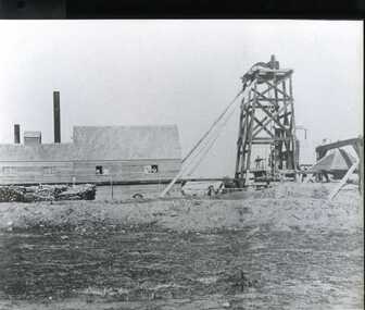 Clunes Museum
Photograph, C. NETTLETON, PHOTOGRAPHER, MELBOURNE, SOUTH CLUNES QUARTZ MINING, CIRCA 1865
.1 SEPIA PHOTOGRAPH OF SOUTH CLUNES QUARTZ MINING CO., CLUNES. 1865. .2 BLACK AND WHITE PHOTO PRINT .3 BLACK AND WHITE PHOTO PRINT OF POPPET HEADSOUTH CLUNES QUARTZ MINING COMPANY, REGISTERED, CLUNES.photographs, mining., south clunes quartz mining company -
 Federation University Historical Collection
Photograph, Gippsland Institute of Advanced Education Staff
Gippsland Institute of Advanced Education is a predecessor institution of Federation University Australia.Gippsland Institute of Advanced Education Staffgippsland institute of advanced education brown coal laboratory technology building, staff -
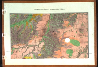 Federation University Historical Collection
Map, Clunes, Mt Greenock, and Talbot Gold Fields, 1883, 1883
A geological plan of the Clunes, Mt Greenock, and Talbot Gold Fields in two parts. .1) This section of the map includes Talbot, Talbot water supply race, Mt Glasgow, Little Green Hill, Middle Hill, Mt Cameron, Ballarat Hill, Bakery Hill, Goodwoman Hill, Scandanavian Lead, Eglinton Swamp, McCallum's Creek, Tullaroop Creek, Dunach, Maryborough Railway, Middle Creek and includes many mines such as Rip Van Winkel, Union Extended, South Greenock, Nicholl's Freehold. .2) This section of the map includes McCallums, Clunes, Green Hill, Mt Beckworth, Mt Gap, Maryborough Reservoir, and includes mines such as Lothair, Bute, Clyde, Clunes Consols, London and Australian, Oriental,clunes, talbot, water supply, railway, geology -
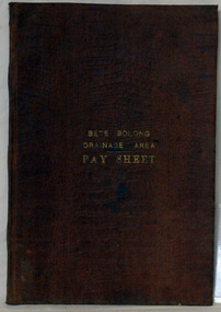 Orbost & District Historical Society
account book, BETE BOLONG DRAINAGE AREA PAY SHEET, 1910 - 1913
This account book was used by the Orbost Shire council to record payments made for work done on the Bete Bolong Drainage Area between 1910 and 1913. The item was donated to Orbost & District Historical society from P.R.O.V. as a Place of Deposit (POD) item for safe keeping by a local history group or museum. The shire covered an area of 9,347 square kilometres and existed from 1892 until 1994 when it became part of the East Gippsland Shire Council. Orbost was at first included in the Bairnsdale Shire from 1882 and was later part of the Tambo Shire. Because of travelling distances the Croajingalong Shire was created in 1892 (name changed to Orbost Shire 17.2.1893 with James Cameron as the first Shire President. In 1994 it amalgamated to become part of East Gippsland Shire Council. This item is a hand-written record of the accounts of the local government. The Orbost Shire Council no longer exists having been absorbed by the East Gippsland Shire Council.A brown leatherette, hard cover book. In gold lettering on the front is "BETE BOLONG DRAINAGE AREA PAY SHEET". It contains records of payments made for work done 1910-1913.In gold lettering on the front is "BETE BOLONG DRAINAGE AREA PAY SHEET".bete-bolong-drainage-area accounts orbost-shire -council -
Stawell Historical Society Inc
Archive, Prince Alfred Quartz Mining Company Minute Book Dec 1874 - May 1885, 1874 - 1885
Minute Book for company Meetings Dec 1874- May 1885.Cover in poor conditionstawell, mining, prince alfred