Showing 779 items
matching hand drawn
-
 Federation University Historical Collection
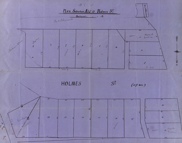
Map, Plan subdivision: Allotment 12 Holmes Street, Ballarat
... The Allotments drawn in Holmes Street appear to be hand... The Allotments drawn in Holmes Street appear to be hand drawn and showing ...The Allotments drawn in Holmes Street appear to be hand drawn and showing one of the first subdivisions in Ballarat. This was begun in the 1860s. Some names are marked on the blocks - Taylor (9), Holmes (6), Robert Watson (3), Watson (16), Walter (18),Wetherly (11), Vacant (7)Blue paper with black ink showing the land blocks either side of Holmes Street Each block is numbered - 20 in all Names on some blocksNorth indicated with arrow Sizes of blocks - depth and width holmes street, subdivision, allotment 12, holmes, taylor, robert watson, watson, wetherly, vacant -
 Melbourne Legacy
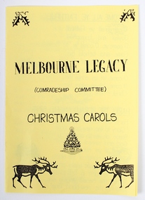
Programme, Melbourne Legacy (Comradeship Committee) Christmas Carols
... of the Comradeship Committee. The hand drawn images and handwritten song... Committee. The hand drawn images and handwritten song lyrics have ...A leaflet created for a Christmas gathering of the Comradeship Committee. The hand drawn images and handwritten song lyrics have been printed on yellow paper. The songs include; O Come All Ye Faithful, Silent Night, Hark the Herald Angels, White Christmas and Jingle Bells.Comradeship meetings were very important to the Legatees. Legatees supported each other by coming together for various events throughout the year. This carol booklet shows that Legatees enjoyed singing together.Yellow paper program containing lyrics of Christmas carols, single A4 page folded in half.comradeship, songs, legatee event -
 Kiewa Valley Historical Society
Photograph - Bogong Village (7 copies), Approx 1940
... . Kiewa House, General offices and test lab to the right. Hand... lab to the right. Hand drawn map on the back of one photo. Set ...In 1940 Field Headquarters for the Kiewa Scheme were established at Bogong with office, workshop facilities and accommodation for workmen, staff and some families constructed. (There had been a 'tent camp' on this site in 1939 but was destroyed by bushfires) Construction of accommodation continued until 1947. A total of 40 houses plus a hostel for single staff, post office, police station, medical centre and primary school all with water and sewerage and electricity supply. The staff hostel was known as Kiewa House and is now occupied by the Education Department. Lake Guy was named after Mr. L.T. Guy who was the Resident Engineer in charge of construction work and associated activities on the Kiewa area. He held this position from 1939 to November 1946 when he was transferred to Head Office. The Bogong Township was developed firstly as an accommodation centre (base camp) for construction workers employed under the Kiewa Hydroelectric Scheme. Due to the influx of European workers into the Township the beautification of the immediate surrounds (gardens etc.) had a distinct European flavour. This environment has been very beneficial for tourism in later years. At the completion of the scheme, in the 1960's, the village was opened to public/tourism use. Strict environmental control has not allowed for any extensive redevelopment in tourist accommodation and basically restricted it to the accommodation initially built for the construction workers. Activities such a bike riding, snow skiing, restricted horse riding and bush walking on the Alpine plains and mountains are now a viable part of the Kiewa Valley Tourist Industry. The lake is one of the many water storage reservoirs used to supply the power stations their main power to run the huge turbines generating the final product, electricity. Evidence can be seen of the 1939 bushfires.Set of 7 identical black and white photographs of Bogong Village after 1939 bush firesHandwritten on the back of one photo - Bogong Village approx. 1940, after 1939 bush fires. Staff residences to left. Kiewa House, General offices and test lab to the right. Hand drawn map on the back of one photo.bogong village, secv -
 Bendigo Military Museum
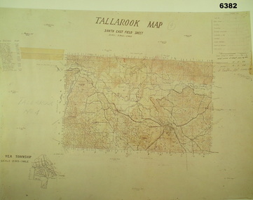
Map - Australian Topographical Survey TALLAROOK SE Sheet, 1 inch:1 Mile, NW portion Plane Table Field sheet 1923, Australian Survey Corps, 1923
... TALLAROOK SE field Sheet,1 inch:1 Mile, hand drawn contoured Plane... TALLAROOK SE field Sheet,1 inch:1 Mile, hand drawn contoured Plane ...This is a coloured reproduction print of an original Plane Table compilation map sheet of Tallarook area 1inch to 1 Mile scale compiled by Sgt Jack Cullen Australian Survey Corps 12 November 1923 and signed by Capt J Lynch. Capt Lynch and Sgt Cullen were both foundation members of the Australian Survey Corps. Of particular interest is the fact that this is a heighted compilation with contouring (required for Military use) as many early maps were purely planimetric. The reverse side of this print is a copy of the Nagambie plane table South West field sheet.Reprinted coloured Image of Australian Topographical Survey TALLAROOK SE field Sheet,1 inch:1 Mile, hand drawn contoured Plane Table Field sheet. Signed by Sgt J Cullen Australian Survey Corps November1923. An enlargement of YEA Township 2 Inches to 1 Mile Scale.royal australian survey corps, rasvy, fortuna, army survey regiment, army svy regt, asr -
 Bendigo Historical Society Inc.
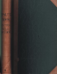
Document - MCCOLL, RANKIN AND STANISTREET COLLECTION: CENTRAL NELL GWYNNE GMC N L - MINUTE BOOK, 1946 - 1955
... written minute book. Dated 20/12/1946 - 24/6/1955. 2 hand drawn... written minute book. Dated 20/12/1946 - 24/6/1955. 2 hand drawn ...Document. Leather bound (tan) green cardboard cover. Hand written minute book. Dated 20/12/1946 - 24/6/1955. 2 hand drawn maps of mine on drafting paper. Letters re sale of buildings, battery & equipment for cost of 7500 pound. Complete description of battery.McColl, Rankin & Stanistreetorganization, business, central nell gwynne, mccoll, rankin & stanistreet, central nell gwynne gmc n l, gold mining, minute book -
 University of Melbourne, Burnley Campus Archives
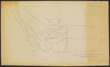
Plan - Sketch, School of Horticulture - Burnley, 1957
... A,B,C,E paper copies, D, tracing paper copy of plan. Hand... paper copy of plan. Hand drawn sketch of central area of grounds ...A,B,C,E paper copies, D, tracing paper copy of plan. Hand drawn sketch of central area of grounds. Figures given for acreage of ornamentals, crops and grazing although only 1 acreage is shown on plan. (E) has further annotation. Scale 1 inch:40 ft.burnley gardens, ornmental, crops, grazing, burnley school of horticulture -
 Bendigo Historical Society Inc.
Plan - Bendigo East State School Plans 1915
... A photocopy of a hand drawn coloured plan of Bendigo East... Fairbanks A photocopy of a hand drawn coloured plan of Bendigo East ...A photocopy of a hand drawn coloured plan of Bendigo East State School No. 3893 dated 24th April 1915 showing various elevations and sections. Written on the plan are the names Joseph William Fairbanks (building contactor) and J. Hudspeth. The sum of 1097 pounds is also written on the plans. Gemma Starr Collectionbendigo east state school, bendigo schools, gemma starr collection, 1915 bendigo east state school, school plan, joseph william fairbanks -
 Port Melbourne Historical & Preservation Society
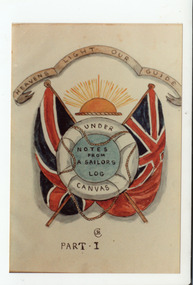
Drawing - Drawings by James Conder
... James Conder 1872-1954: .07 - Hand drawn pictures of "Cerberus... - Hand drawn pictures of "Cerberus" .08 - Drawing of sailing ...From a group of items re ártist, poet and four-navy veteran James Conder 1872-1954: .07 - Hand drawn pictures of "Cerberus" .08 - Drawing of sailing ship with annotations naming all sail types .09 - Hand illustrated sheet from "Under Canvas - Notes from a sailor's log"armed services - navy, transport - shipping, james bryance conder, royal australian navy, royal navy squadron, victorian navy, royal australian naval college, australian merchant navy -
 Ballarat Tramway Museum
Map, Ballarat and Bendigo tram systems, 1960's or 1970's
... Set of two hand drawn maps of the Ballarat and Bendigo tram... tramways Map Drawings Ballarat Bendigo Set of two hand drawn maps ...Yields information about the extent of the Ballarat and Bendigo tramway systems and possibly has a strong association with the work of Tom Murray.Set of two hand drawn maps of the Ballarat and Bendigo tram systems, showing loops, terminus, depots and rail lines, including out of use loops and reserved track. Possibly made during the 1960's or early 1970's. Drawn on lined foolscap paper - have been torn from a pad.trams, tramways, map, drawings, ballarat, bendigo -
 Kew Historical Society Inc
Plan - Subdivision : Cotham and Glenferrie Roads, J R Mathers & McMillan
... An undated and untitled hand-drawn and coloured subdivision... , stirling avenue street - kew An undated and untitled hand-drawn ...The Kew Historical Society's map collection includes a substantial number of real estate subdivision plans, mainly of Kew but also of surrounding suburbs in Melbourne. Most of the subdivision plans date from the 1920s and 1930s when the districts old homes and local farmland were being split up to accommodate residential growth in the postwar period. These early plans were assembled by a local firm, Jas R Mather & McMillan, which had an office in Cotham Road. Many of the plans, and sometimes photos, were annotated by the agents.Subdivision plans are historically important documents used as evidence for the growth of suburbs in Australia. They frequently provide information about when the land was sold as well as evidence relating to surveyors and real estate and financial agents. The numerous subdivision plans in the Kew Historical Society's collection represent working documents, ranging from the initial sketches made in planning a subdivision to printed plans on which auctioneers or agents listed the prices for which individual lots were sold. In a number of cases, the reverse of a subdivision plan in the collection includes a photograph of a house that was also for sale by the agent. These photographs provide significant heritage information relating house design and decoration, fencing and household gardens.The photograph may also be aesthetically significant depending on the importance of the photographic atelier.An undated and untitled hand-drawn and coloured subdivision plan detailing the boundaries of a number of irregular allotments bordering Cotham Road, Glenferrie Road and Stirling Avenue (now Stirling Street). The plan predates the actual subdivision that led to the creation of the eight commercial properties occupying 118-132 Cotham Road. The plan may represent an old subdivision that was further subdivided at a later date, or it may be a subdivision that never eventuated. On MMBW Detail Plan 1575 (1903), the area represented by the proposed subdivision was residential rather than commercial. The irregularity of lots is also apparent in the MMBW Plan. The largest of the unnumbered blocks on the hand-drawn subdivision plan may relate to the boundaries of the nineteenth century mansion identified as ‘Kelso’ on the MMBW Plan.subdivision plans - kew, cotham road - kew,, glenferrie road - kew , stirling avenue street - kew -
 Bendigo Historical Society Inc.
Photograph - GOLDEN SQUARE LAUREL STREET P.S. COLLECTION: PHOTOGRAPH ALBUM 1984
... enclosed. Hand printed 'Happy Days at Laurel Street' with hand... printed 'Happy Days at Laurel Street' with hand drawn depictions ...Laurel St primary school pupils Grade 5-6 1984 colour photographs mounted in red covered album. Christian names as captions. Mr Rodda captioned as cricket coach amongst sporting people enclosed. Hand printed 'Happy Days at Laurel Street' with hand drawn depictions of children playing games.bendigo, institutions, golden square primary school -
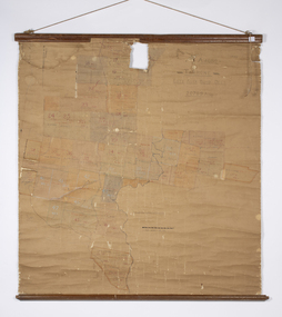
![Plan, Improvements on the Camp Reserve Ballarat, 1870, 26/4/1870 (exact); Traced by Henry [Mornes?], district surveyor, on the above date](/media/collectors/4f729f6797f83e0308601707/items/4f72a4fa97f83e0308602508/item-media/59b79d3921ea680200c6b8a7/item-fit-380x285.jpg) Federation University Historical Collection
Federation University Historical CollectionPlan, Improvements on the Camp Reserve Ballarat, 1870, 26/4/1870 (exact); Traced by Henry [Mornes?], district surveyor, on the above date
... Hand-drawn plan on white linen showing the camp reserve... buildings goldfields administration Eureka Stockade Hand-drawn plan ...The Ballarat Camp housed the Goldfields administrators. It was from this site that the troopers left on the morning of 3 December 1854 to attack the Eureka Stockade. Much of the area shown in on the west side of Camp Street is now used by the Federation University Arts Academy.Hand-drawn plan on white linen showing the camp reserve in what is now known Ballarat's Camp Street. The plan shows allotments in an area bounded by Mair, Sturt and Lydiard Streets. The plan has colours indicating wooden buildings, stone buildings, brick buildings, Wood & zinc buildings, and wood & brick buildings.ballarat, camp street, horace walker, henry mornes, goldfields architecture, reserve for public, buildings, goldfields administration, eureka stockade -
Clunes Museum
Textile - DOLLS CLOTHES, 1932
... .2 Hand-sewn Apron, white with mauve binding, hand drawn... with mauve binding, hand drawn design .3 Hand-sewn neck to knee ....1 Hand-sewn pale green hat, pink and grey flowers as trim .2 Hand-sewn Apron, white with mauve binding, hand drawn design .3 Hand-sewn neck to knee swimsuit, lisle material, pink and brown .4 Hand-sewn flannelette night dress, hand embroidered flower on frontNilbrusaschi, dolls clothes, 1932, hand-sewn -
 Melbourne Tram Museum
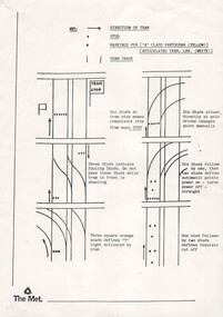
Document - Instruction, The Met, "Stud Markings for (A class tram pantograph (yellow)) and (Articulated Tram LRV White)", c1985
... , compulsory stops and insulator cut offs. Shows a hand drawn plan..., compulsory stops and insulator cut offs. Shows a hand drawn plan. Has ...Instruction - single A4 sheet - "Stud Markings for (A class tram pantograph (yellow)) and (Articulated Tram LRV White)" - not dated, setting out marks for tram stops, cross overs, junctions, compulsory stops and insulator cut offs. Shows a hand drawn plan. Has the early "The Met" logo in the bottom left hand corner.trams, tramways, stud marking, tram driving, crossover, tram stops -
 Bendigo Historical Society Inc.
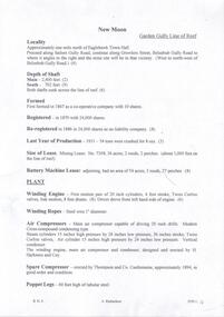
Document - NEW MOON MINE - NOTES ON THE NEW MOON MINE
... production and dividends. Hand drawn locality map included. Albert... production and dividends. Hand drawn locality map included. Albert ...Four typed copies of notes on the New Moon Mine on the Garden Gully Line of Reef. Notes include locality, depth of shaft, last year of production, size of lease, plant, Telephone and electric signalling, early history, gold obtained, prominence, gold production and dividends. Hand drawn locality map included. Albert Richardson Collection.cottage, miners, new moon mine, notes on the new moon mine, h harkness & coy, thompson & co, telephone & electric signalling, 'robin hood' ground, bendigo amalgamated goldfields co, special edition australian mining standard 1/6/1899, mines dept booklet 'bendigo goldfields' 1936, mines dept annual and quarterly reports, annals of bendigo mining section 1907 = 1931, a richardson, souvenir 'declaration of 200th dividend' issued by directors of new moon co 1/12/1906, mines dept bulletin 47 'structure of bendigo goldfields' h herman 1923 -
 Phillip Island and District Historical Society Inc.
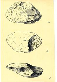
Drawing
... Aboriginal Hand Axe. Drawn by Dr L Adam, University of Melbourne.... of the same Aboriginal Hand Axe. Drawn by Dr L Adam, University ...One of several drawings included in a collection of over 400 photographs in an album commenced in 1960 and presented to the Phillip Island & Westernport Historical Society by the Shire of Phillip IslandBlack & White Pen drawing depicting three views of the same Aboriginal Hand Axe. Drawn by Dr L Adam, University of Melbourne.local history, illustrations, pen & ink, aboriginal hand axe, aboriginal tools, john jenner, bryant west, dr l adam -
Glen Eira Historical Society
Letter - Anselm, Glenferrie Street, 4, Caulfield North
... -drawn room plans (100mm x 82mm; 81mm x 75mm), detailed hand... a photocopy of two hand-drawn room plans (100mm x 82mm; 81mm x 75mm ...Various detailed descriptions of the architectural features of Anselm. Includes a photocopy of the Caulfield Conservation Study report on Anselm by Andrew Ward, dated 02/1994, with a photo (152mm x 97mm). Also includes 3 pages of unattributed, undated, typed and handwritten research notes with detailed descriptions of the architectural features of Anselm. Also includes a photocopy of two hand-drawn room plans (100mm x 82mm; 81mm x 75mm), detailed hand-written descriptions of the rooms (3 pages) and a hand-drawn crest (41mm x 29mm), compiled by Mrs J O’Donnell in 1972. The file also includes a copy of the tile and inscription located at the base of the tower (41 mm x 56 mm). Also included is a copy of the letter, dated 31/10/2011, from the National Trust of Australia, regarding the classification upgrading of Anselm. Includes references.cohen samuel, haddon robert joseph, graham c. g., o’donnell j., ward andrew, anselm, caulfield north, glenferrie street, balaclava road, st. stephen’s presbyterian church caulfield, architectural features, architectural styles, attics, towers -
 Orbost & District Historical Society
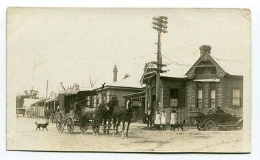
black and white photograph, C 1915 -1920
... street of Orbost. There is a hand-drawn cross on the roof.... There is a hand-drawn cross on the roof of the building adjacent the post ...This photograph shows the main street of Orbost and in particular, the Orbost Post Office. The wagon in the photograph is on its way to Cann River.This photograph is a pictorial record of the township of Orbost in the early 20th century,A black / white photograph with a cart drawn by three horses. Standing in the street are three young girls and a man. There is a motor car, roof down, on the right hand side. There are two dogs in the photograph whic has been taken outside the post office in the main street of Orbost. There is a hand-drawn cross on the roof of the building adjacent the post office. Buildings are wooden.on back - "X indicates bank, caravan and ? horses is coach bound for Cann River, meeting place"transport-orbost post-office-orbost -
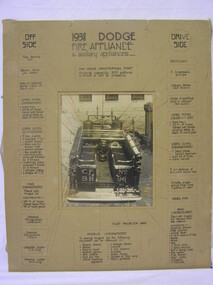 Ballarat Fire Brigade
poster
... to position on photograph appear to be hand drawn (possibly at later... list to position on photograph appear to be hand drawn ...Poster was probably made as a training aide for newer members or display purposes for public talks. Original vehicle still owned by brigadeB&W photograph of brigades 1938 Dodge pumper taken from rear of appliance. Photograph shows appliance fully stowed and has an inventory of stowed equipment listed down both sides of poster with photo located in centre. aroows from item list to position on photograph appear to be hand drawn (possibly at later date) in red pen. 1938 Dodge fire appliance & auxiliary appliances, (numerous further inscriptions as per photograph of poster) -
 Warrnambool and District Historical Society Inc.
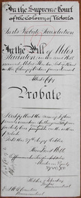
Document - Miles Staunton Probate 1895, 1898
... seal attached but there is a hand-drawn circular sketch... seal attached but there is a hand-drawn circular sketch ...Tait collection: item 46 of 62 This is a document giving details of the Will and Probate of Miles Staunton (called Miles Stanton in the Will and Myles Staunton in the official Victorian death records). He died at Tower Hill in 1898 at the age of 72. He was a farmer in the Koroit district and left real estate to the value of £2799 and personal estate to the value of £128. The chief beneficiaries were his wife and children. Miles Stanton was unable to write and signed his will with a cross. The lawyers involved, Fletcher and Mackay and Ernest Chambers, had legal offices in Warrnambool at the end of the 19th century. The document, with others, was passed down to successive lawyers occupying the legal premises in Kepler street (Fletcher and Mackay, later Mackay Taylor) and located in this building in 2014. This document is of some interest as it gives details of the Will and Probate of Miles Staunton who was a 19th century farmer in the Koroit district.This is a white piece of paper folded in two to make four pages. Three of the pages have ruled margins in red and there is handwritten material on four pages in black ink. There is no proper seal attached but there is a hand-drawn circular sketch representing the seal of the Supreme Court of Victoria. The document contains information on the Will and Probate of Miles Staunton of Koroit who died in 1898.In the Supreme Court of the Colony of Victoria In the Probate Jurisdiction In the Will of Miles Staunton in the Will named Miles Stanton late of Koroit in the Colony of Victoria farmer deceasedmiles staunton, ernest chambers, fletcher and mackay, warrnambool, tait collection -
Yarra Glen & District Historical Society
Maps, Steels Creek 1956
... Hand drawn map of Steels Creek on A4 paper. Red, blue... mud map sketch plan Hand drawn map of Steels Creek on A4 paper ...Ronald J Arney was a resident of Steels CreekHand drawn map of Steels Creek on A4 paper. Red, blue and black biro. Covers the area north of Willowbend Road to the end of Greenwood Lane. Shows location of homes of people residing in Steels Creek in 1956, landmarks such as ruins and huts, roads and creeks. Several other features have been added in black biro in another hand.steels creek, mud map, sketch plan -
Bendigo Historical Society Inc.
Map - DEVONSHIRE MINES - MAP WITH UNITED DEVONSHIRE & PRINCESS ALEXNDRA (ALEXANDRA)
... Hand drawn map taken from Caleb Thomas Plan, Sheet 774... Princess Alexndra Caleb Thomas Plan Hand drawn map taken from Caleb ...Hand drawn map taken from Caleb Thomas Plan, Sheet 774 (No ?1) 4/12/1885. Map shows shaft No 18 (Princess Alexndra [Alexandra], Lease No 4567) and shaft No 19 (United Devonshire) depths of some of the levels and geological information. Two mismatched pieces of drafting sheet stuck together with sticky tape and staples.mine, gold, devonshire mines, devonshire mines, united devonshire, princess alexndra, caleb thomas plan -
 Bendigo Historical Society Inc.
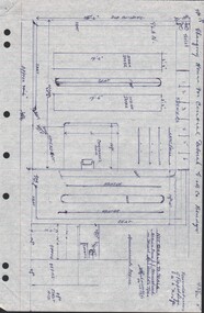
Document - CENTRAL DEBORAH GOLD MINE - PLAN OF CHANGING HOUSE
... Hand drawn plan for Changing House for Central Deborah G. M... of Changing House A Richardson Mines Dept. Surface Plan 15/1/1954 Hand ...Hand drawn plan for Changing House for Central Deborah G. M. Co. Bendigo. Drawn by A. Richardson 14/11/1971. Drawing has approx. measurements and is not drawn to scale. Also some Central Deborah Gold Mine Information . Ref. Mines Dept. Surface Plan 15/1/1954. Written by A Richardson 14/12/1971.mine, gold, central deborah gold mine, central deborah gold mine, plan of changing house, a richardson, mines dept. surface plan 15/1/1954 -
 Bendigo Historical Society Inc.
Document - MCCOLL, RANKIN AND STANISTREET COLLECTION: SOUTH DEBORAH GOLD MINES NL GOLD LEASE DOCUMENT, 14/1/1941
... ' application Atherton 14/4/46 - consent refused - hand drawn map... Atherton 14/4/46 - consent refused - hand drawn map with Honeybone ...Document: McColl, Rankin and Stanistreet - South Deborah Gold Mines NL. Gold mining lease document. No. 11141, Vol. 325, Fol. 35893. Lease adjoins Railway Reserve, Breen Street. Attached to plan with pin piece of paper, written in pencil ' application Atherton 14/4/46 - consent refused - hand drawn map with Honeybone Street.organization, mining, south deborah gold mines nl, mccoll, rankin and stanistreet, south deborah gold mines nl, gold mining lease documents -
Glen Eira Historical Society
Map - Caulfield Fire Station, No 26, Tree Reserve, Dandenong Road
... A one page photocopy of an undated, unattributed, hand..., unattributed, hand drawn map (200mm x 290mm) of the location on Tree ...A one page photocopy of an undated, unattributed, hand drawn map (200mm x 290mm) of the location on Tree Reserve, Dandenong Road, of the Caulfield Fire station, No 26. The map includes handwritten notes showing various nearby property owners. The file also includes a photocopy of a one page, undated and unattributed printout of the site address and site lease date.caulfield east, caulfield fire station, dandenong road, derby road, racecourse road, tree reserve, shire of caulfield, federal bank, st james building society, delves murchison, fire stations -
Glen Eira Historical Society
Document - Clarence Court Elsternwick
... for the year ending 31 December 1987, plus a hand-drawn map showing... report for the year ending 31 December 1987, plus a hand-drawn ...This file contains one item pertaining to Anglican Homes for Elderly People in Clarence Court, Elsternwick: 1/A bundle of documents, including a list of the names of office bearers, the annual report and financial statement, the balance sheet, the income and expenditure statement and the auditor’s report for the year ending 31 December 1987, plus a hand-drawn map showing the location of the Court.elsternwick, clarence court, st. catherine’s, trinity court, mcgregor j. mrs., arden d. mr, howlett g. mr., riley d. mr., hare j. mrs., curzon-siggers e. mrs., guy j. mr., hurst p. mr., lang d. dr., rowland a. mr., weickhardt g. mr., buegg m. mrs., henham f. miss, wright l. mrs., sister james walter, nellor w. reverend, davis r. reverend, hislop j. reverend, cleary r. reverend, yelland r. mr., danby bland proven + co. -
Bialik College
Work on paper (Item) - Bnei Mitzvah 2023 bunting
... in relation to their Bnei Mitzvah. Some pictures are hand drawn... in relation to their Bnei Mitzvah. Some pictures are hand drawn ...2023 Year 7 Students created family emblems and/or crests in relation to their Bnei Mitzvah. Some pictures are hand drawn and copied in colour, others are computer generated. Some are original images which others are a composite of online open access material. Four portions are missing, one removed due to mildew Please contact [email protected] to request access to this record. bnei mitzvah, hebrew, jewish school, art, display, exhibition -
 Warrnambool and District Historical Society Inc.
Map - Soldier Settlement Map, Soldier Settlement Commission, Tarrone Estate Alex Boyd, 1940s
... of allotments, hand drawn and with faded colours in red, blue... at the top. It is a map of allotments, hand drawn and with faded ...This is a map of the Tarrone Soldier Settlement land divisions probably produced by the Soldier Settlement Commission. The map is incomplete with lots 48,49 and 50 missing. The Soldier Settlement Commission purchased 23,373 acres of Tarrone Station from the Boyd brothers in 1947 and the sub divided lots were occupied by soldier settlers commencing in 1949. Tarrone Station was established in 1840 by Doctors Kilgour and Bernard and the Boyd brothers secured the free hold in the 1890s and retained it until 1947. The map hung for many years in the Warrong school near Hawkesdale.This map is of considerable interest as an original item from the establishment of the Tarrone Soldier Settlement..The map is made of brown cloth and creased. The edges are tattered and there is a piece missing at the top. It is a map of allotments, hand drawn and with faded colours in red, blue and yellow. The names of localities and land holders are hand written in ink and chalk. The map is contained within two pieces of wood at the bottom and the top. There are two screws and a cord to hang on a wall. A scale of measurement is shown under the map. tarrone soldiers settlement, boyd brothers tarrone -
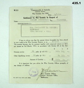 Bendigo Military Museum
Work on paper - DOCUMENT, ORDER OF SERVICE, POEMS, 1) 1939 -1945 .2) 1944 .3)1943
... single sheet, hand drawn cover in black. .3) Poems, "My Mothers...". Beige colour, folded single sheet, hand drawn cover in black. .3 ...The items belonged to Frederick Ernest ADDLEM VX142253. Refer Cat No 432.2 for his service history and 937P. .1) Document, "Entitlement to War Gratuity" of 152 Pounds 5 Shillings. Beige paper wth black print and typing. .2) "A Special Prayer Service for Allied Invasion Forces". Beige colour, folded single sheet, hand drawn cover in black. .3) Poems, "My Mothers Smile", I'll remember". On beige paper, hand written in ink on ruled lines..1) 1.7.46, ADDLEM Frederick E. VX142253. .2) 112 Aust Con Depot New Guinea Sun 11 June 44. .3) 1943. Dear Fred sent me these verses.documents - religon, ceremonies -
University of Melbourne, Burnley Campus Archives
Book - Register, The Orchard at Burnley Gardens, 22.05.1955
... Typed manuscript, which includes hand-drawn maps and typed... manuscript, which includes hand-drawn maps and typed tables ...No. 237 handwritten. No. 01310H Norman Bros. Pty. Ltd. 60-62 Elizabeth St., Melbourneorchard, field station, history, fruit tree blocks, planting plans, newspaper cutting, red delicious apple, preston prolific fig