Showing 5053 items
matching housing development
-
 The Beechworth Burke Museum
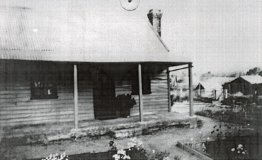
Photograph, c1900
This photograph shows a small timber house in Wooragee. In 1855, the Ovens district made a shift towards farming development that included the sales of land in the Wooragee Valley. This shift came because of miner's demands and concern about stabilising the area around the goldfield. Continual migration needed to be supported, unlucky diggers needed alternative employment, and there was a lack of affordable fresh produce available on the goldfields. Initially, the cost of land in areas like Wooragee was prohibitive, and miners chose to squat rather than overpay for poor land. Throughout the 1850s and 1860s, land reform was a key topic for miners and politicians, as they attempted to improve land access and protect financial interests. This photograph is an example of rural development in the Wooragee area, showing the cottage, tents, and garden beds. While the date is unknown, the image nevertheless links us to the 1850s-1860s story of rural development in Indigo Shire. Black and white rectangular photo, copy of original, printed on paper. wooragee, timber, timber cottage, corrugated iron, cottage, housing, tents, gardening, farming, farming and agriculture, construction, garden bed, flowers, verandah, squatting, tent, field -
 The Beechworth Burke Museum
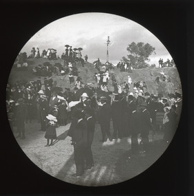
Photograph - Lantern Slide, 1901
This glass slide captures the unveiling of the two cannons at Queen Victoria Park which were secured by Sir Isaac Isaacs and presented to Beechworth in 1901. In the foreground, elegantly dressed ladies and dapper gentlemen can be seen gathering around the park's iconic rock, with excited children looking on from the sides. Atop of the rock stands an intricately designed gas lamp that has since been removed but evidence of its existence still remains. The unveiling of these two cannons would have been a celebratory affair for those in attendance, marking a momentous occasion for Beechworth residents that was captured in this lantern slide. Sir Isaac Isaacs was an influential figure in Beechworth, having grown up and studied there. He began his education at the Common school and eventually graduated as dux of the Beechworth Grammar School. His commitment to public service was evident early on and he was elected to the Legislative Assembly in 1892, representing Bogong, a district which included Yackandandah and Beechworth. During his time in office he pushed for better education, healthcare, employment opportunities and housing for the people of Beechworth. Lantern slides, sometimes called 'magic lantern' slides, are glass plates on which an image has been secured for the purpose of projection. Glass slides were etched or hand-painted for this purpose from the Eighteenth Century but the process became more popular and accessible to the public with the development of photographic-emulsion slides used with a 'Magic Lantern' device in the mid-Nineteenth Century. Photographic lantern slides comprise a double-negative emulsion layer (forming a positive image) between thin glass plates that are bound together. A number of processes existed to form and bind the emulsion layer to the base plate, including the albumen, wet plate collodion, gelatine dry plate and woodburytype techniques. Lantern slides and magic lantern technologies are seen as foundational precursors to the development of modern photography and film-making techniques.This glass slide captures social and historical significance as it represents a moment of celebration for Beechworth residents and symbolises an important milestone in the town's history. This lantern slide stands testament to a special moment in Beechworth’s history and its significance continues to be remembered today. It is also an example of an early photographic and film-making technology in use in regional Victoria in the time period.Thin translucent sheet of glass with a circular image printed on the front and framed in a black backing. It is held together by metals strips to secure the edges of the slide. burke museum, beechworth, lantern slide, slide, glass slide, plate, burke museum collection, photograph, monochrome, queen victoria park, rock, victoria, cannons, isaac isaacs, governor-general, politicians, judges, indigo shire, north-east victoria, 19th century, nineteenth century, parks -
 Flagstaff Hill Maritime Museum and Village
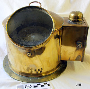
Instrument - Compass and Housing, 1880-1900
This compass was used to determine directions using a free-moving magnetised needle, indicating north and south. W Hartmann was a compass maker located in Hamburg Germany some of his compasses are marked “Gehna” and “Nautica”. There is no information available regards W Hartmann, his successor in the business was “Georg Hechelmann” a marine instrument maker of which Gehna is an acronym of his name. In 1874 he patented an improved version of “Lord Kelvin Thomson’s” compass design of a paper rose with magnets hung on silk threads. It appears he worked in his shop from around 1878 until probably 1905. The company he founded "Gehna" is today a substantial international marine corporation and is still based in Hamburg. A rare example of an early binnacle and compass probably used on a sailing vessel. It is a significant item not only for it’s rarity but also because it demonstrates the progress of marine navigational instrument development in the late 19th century. The item was made by an early pioneer and innovator of marine navigation and instrument making. Compass and Housing; the brass housing, with side light box, insides a fluid dampening gimble compass. The maker is W Hermann/Georg Hechelmann, of Hamburg, Germany. The inscription ioncludes the number of the compass.Made by W Hartmann/Georg Hechelmann of Hamburg, No 7208flagstaff hill, warrnambool, shipwrecked-coast, flagstaff-hill, flagstaff-hill-maritime-museum, maritime-museum, shipwreck-coast, flagstaff-hill-maritime-village, compass and housing, w hartmann, binnacle, georg hechelmann, navigational instrument, ship compass -
 Flagstaff Hill Maritime Museum and Village
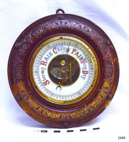
Instrument - Barometer, Early 20th century
A barometer is an instrument used for measuring atmosphere pressure thus determining weather changes.The first apparatus generally accepted as a barometer was that set up in Florence in 1644 by Evangelista Torricelli (1608–1647), a mathematician and physicist. Torricelli filled a glass tube with mercury, sealed it at one end, and inverted it with its open end in a dish of mercury. The level always fell a short way down the tube, then settled at a height of about thirty inches. He concluded correctly that the mercury column was sustained by the weight of the air pressing on the open surface of mercury, and further experiments convinced him that the space above the mercury in the tube was a vacuum. He noted that the level rose and fell with changing temperature, but he was unable to use his apparatus to measure variations in the weight of the atmosphere because he had not foreseen that temperature would affect the level of the mercury. News of this experiment circulated quickly among European scientists, who hastened to replicate the experiment. Torricelli's conclusions were not universally accepted because some disputed whether the air had weight, while both Aristotle and the Catholic Church denied the possibility of a vacuum. In France, the philosopher René Descartes (1596–1650) seems to have been the first person, probably in 1647, to attach a graduated scale to the tube so that he could record any changes attributable to the weather. At around this time Duke Ferdinand II of Tuscany organized the first short-lived meteorological network among scientists in other Italian cities, gathering observations of pressure, temperature, humidity, wind direction, and state of the sky.Theis barometer is an example of a household item from the early 20th century, used to determine the day's weather. The barometer is significant as an aid to human social, material and scientific development.Barometer, round, brass housing inset into carved wooden casing (lacquer mostly worn off). Decorative lettering for weather conditions "Stormy, Rain, Change, Fair, Very Dry". Workings are visible through opening in centre of dial. Indicator needle and another adjustable needle . Hook screwed into back of case.flagstaff hill, warrnambool, shipwrecked coast, flagstaff hill maritime museum, maritime museum, shipwreck coast, flagstaff hill maritime village, great ocean road, barometer, scientific instrument, weather forcasting instrument, weather gauge -
 Phillip Island and District Historical Society Inc.
Booklet, Phillip Island Holidays Development Pty Ltd, Ideal Summerland on the Nobbies, Phillip Island, Late 1920s
Subdivision of Summerlands commenced in the 1920s with 12 large allotments created, along with features such as a roundabout and cypress trees. Between 1927 and 1931, 227 new blocks were created, and from 1929 to 1940 there was a nine-hole golf course on what is now the Penguin Parade car park.Historical Large 8 page glossy booklet advertising Summerlands Estate, describing attractions of the area ,maps, houses , golf course. Basically black and white with some orange print and a coloured map.Ideal Summerland on the Nobbies Phillip Island. "The land of somewhere we long to go". Published by Phillip Island Holidays Development Pty Ltd. 6o Market Street, Melbourne.housing, tourism phillip island, summerland estate -
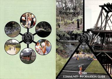 Ringwood and District Historical Society
Booklet, City of Ringwood 1989 Community Information Guide, 1989
Community information booklet issued by City of Ringwood for 1989 - covering the facilities and activities of the Ringwood Council and other local organisations and associations. Cover photographs: Front - Fern Gully at Ringwood Lake, Poppett Head at rear of Lake, Athletics Track. Back - Highland Carnival, Wombalano Park, Miners Cottage at Ringwood Lake, Bike Path, Water Cascade at rear of Lake.CONTENTS: (page no.) 1. COUNCIL SERVICES After School Activities Programme 29 Aged Services 31, 32 & 33 Aquatic Centre 20 & 21 Budget 14 Building Information 16 By-Laws 26 Chief Executive's Message 9 Children's Services 29 Civic Centre 4 Committees of Council 5 Common Questions 36 Community Plan 10 & 11 Council Meeting Dates 4 Council Representatives 8 Councillors 6 & 7 Dogs 26 Dual Occupancy 12 Emergency Telephone Numbers 63 Family Day Care 29 Fire Hazards 27 Garbage 34 & 35 Golf Course 24 Home Handyman Services 31 Home Help 31 Incinerators 26 Knaith Road Child Care Centre 29 Library 23 Maternal and Child Health 28 Mayoral Message – Cr. R. Gardini 3 Meals on Wheels 31 Members of Parliament 62 Parks and Gardens 18 Rates 25 Residential Development Provisions 12 & 13 Ringwood Bypass Road 13 Ringwood Convention Centre & Performing Arts Centre 22 Ringwood District Centre 14 Staff 10 Town Planning 17 Works Depot 30 Youth Outreach Worker 33 2. LOCAL COMMUNITY SERVICES Accommodation 37 Alcoholism 37 Birthright 38 Blind 38 Care Force 39 Catholic Family Welfare Bureau 39 Central Ringwood Community Centre 39 Childbirth and Parenting Association 39 & 40 Churches 40 & 41 Community Services Victoria 42 Day Centres and Drop In Centres 43 Do Care 43 Drugs 43 Elderly Day Care 44 Emergency Housing 45 Family Planning Services 45 Financial Counselling 46 Hearing Aid Service 47 Hospitals 47 Housing 48 Information 48 Legal 49 Literacy 50 Lone Parents 50 Marriage Celebrants 50 Maroondah Social Health Centre 51 Neighbourhood Mediation Centre - Outer East 51 North Ringwood Community House 52 Nursing 52 Optometric Services 52 Playgroups 53 Podiatry 53 Pre-Schools 54 Red Cross 55 Retirement 55 Ringwood Croydon Advisory Service 55 Schools 56 & 57 Senior Citizens' Centres 58 Transport 59 Twins 59 Unemployment 60 Volunteering 60 Youth Accommodation Project (Maroondah). 60 Youth Emergency Accommodation Services... 60 rinx -
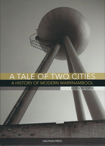 Warrnambool and District Historical Society Inc.
Book, A tale of two cities: a History of Modern Warrnambool, 2015
This book is the story of modern Warrnambool, describing aspects of the city from the 1980s to 2015. It looks at such topics as religion, law, population, housing, infrastructure, employment, industry, health, education and politics. The author, Gordon Forth, was formerly a lecturer in the Faculties of Education and Arts and the Director of the Centre for Regional Development at Deakin University in Warrnambool. He has written and edited a number of books dealing with Warrnambool and district history. Mark Rashleigh, responsible for the design and lay-out of the book and many of the photographs, was a lecturer in visual communication and graphic design in the Faculty of Arts at Deakin University and is now involved with the Warrnambool and District Historical Society in the preparation and cataloguing of historical photographs.The book is of some importance as it is the only comprehensive study of Warrnambool over the past 30 years and complements ‘By These We Flourish’, the story of Warrnambool’s people, places and events up to the 1980s. It is will be of great interest to readers in general and researchers in particularThis is a hardcover book of 320 pages. The dust cover is multi-coloured (black, white and gold) with an image of the water tower at the former Fletcher Jones Factory site on the front cover and an image of the Warrnambool Breakwater on the back cover. The hard cover book has the same colouring and images as the dust cover.Front covers – ‘A Tale of Two Cities – A History of Modern Warrnambool’, ‘Gordon Forth’, ‘Halstead Press’ Spines – ‘A Tale of Two Cities – A History of Modern Warrnambool’, ‘Forth’, ‘Halstead’ Back Covers – ISBN number and code warrnambool, gordon forth, a history of modern warrnambool, a tale of two cities -
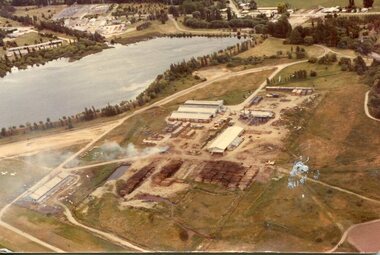 Kiewa Valley Historical Society
Photograph - Mt Beauty timber Industries, 1960's (estimate only)
Hume and Hovell discovered the area in 1824 and by the end of the 19th century the valley was transformed by logging, dairy and beef cattle properties and tobacco farms. Timber was required for construction of McKay Creek Power Station which began construction in 1951 and also the camps and houses for the workers and their families. There was a need for housing and infrastructure for an increasing population of workers for the hydro-electric scheme as there was a general shortage of this commodity. A timber mill was started in Tawonga by Mates, of Albury, in 1945, and electricity became available in 1946 the S.E.C. bought the mill, and enlarged it. In 1960 it was purchase by a local family. They also started a timber mill in Mt Beauty and worked both until 1980 when they closed the Tawonga mill and enlarged the mill called Mt. Beauty Timbers Pty Ltd which employed approximately 50 people. A pictorial record of the development of the Mt Beauty community and the local timber industry.Colour photograph of aerial view of Mt Beauty Timber Mills and surrounding area including pondage and part of airfield. Photo taken in 1960’s (estimate only)Handwritten in ink on back of photograph in very faint writing – Recent photo of Mt Beauty Timber Industries Mt Beauty Operationsmt beauty timber industry, timber industry, timber mill, secv -
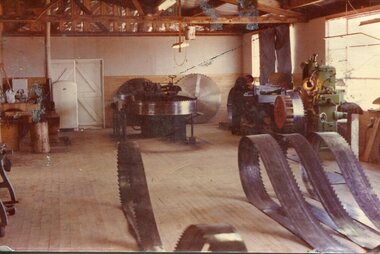 Kiewa Valley Historical Society
Photograph - Mount Beauty Timber Industries, 1960's (estimate only)
Hume and Hovell discovered the area in 1824 and by the end of the 19th century the valley was transformed by logging, dairy and beef cattle properties and tobacco farms. Timber was required for construction of McKay Creek Power Station which began construction in 1951 and also the camps and houses for the workers and their families. There was a need for housing and infrastructure for an increasing population of workers for the hydro-electric scheme as there was a general shortage of this commodity. A timber mill was started in Tawonga by Mates, of Albury, in 1945, and electricity became available in 1946 the S.E.C. bought the mill, and enlarged it. In 1960 it was purchase by a local family. They also started a timber mill in Mt Beauty and worked both until 1980 when they closed the Tawonga mill and enlarged the mill called Mt. Beauty Timbers Pty Ltd which employed approximately 50 people. A pictorial record of the development of the local timber industry in the Kiewa Valley showing equipment used in timber milling.Colour photograph of Mt Beauty Timber Industries Mill. Photo taken inside the workshop showing saw blades and equipmentmt beauty, mt beauty timber industry, timber mill -
 Kiewa Valley Historical Society
Set of 2 hand coloured photographs of early Mount Beauty, photographs of Mount Beauty, 1947/48
Construction of the town of Mount Beauty commenced in 1946 and continued until 1952. It was built to provide family accommodation for workers engaged in the construction of the hydro electric power scheme. As well as housing, there was an administration building, staff hostel, merchandising centre, workmen's camps, base stores and workshops and the Mount Beauty Terminal Station. The first house was occupied in November, 1946 by the then manager of the trading store, with a frontage onto Hollonds Street. The total number of houses erected was 488, 162 custom built and 326 prefabricated. The main workmen's camp can be seen just left of the centre of the photograph and accommodated 144 men at the time of the photograph. By 1950 it could accommodate 1200men. Photo No. 1 is taken in 1947/early 1948 as there is no evidence of the staff hostel under construction. This hostel was commenced in August/September 1948 and is clearly shown in photograph No. 2, dating this photo as 1948 as it is before the completion of the bypass road connecting to the main (high plains) road. This road was constructed in 1939 and in 1948 followed the route of Tawonga Crescent. This remained in use until the bypass construction was completed in early 1949 and does not appear to be finished in this photograph.. Both photographs are taken from the power line easement adjacent to the Bright road.Significant historical pictorial record of the development of a town from grazing land. The type of terrain that had to be surveyed and then to construct roads and other infrastructure, with very little machinery, is also of prime significance in the development of the Kiewa Hydro Electric Scheme.Two photographs, both hand painted to show colours, and both of Mount Beauty c 1947/48 not long after commencement of construction of homes and facilities for workers.Photo No.1 - on back of photo, left upper corner, faintly in pencil, SPIKE, underneath this is written T Pay,. Photo No. 2 - on back of photo, left upper corner, faintly in pencil, Jmount beauty, housing, accommodation -
 Kiewa Valley Historical Society
Folder - Early Photos of Mt Beauty
Mt Beauty township was built during the 1950's to house the employees of the State Electricity Commission working on the Kiewa Hydro Electric Scheme. After the completion of the Kiewa Hydro Electric Scheme many houses were sold and the public buildings handed over to the Alpine Shire. Mt Beauty has always been a tourist destination especially with its proximity to the ski fields at Falls Creek.This folder contains many early photos of Mt Beauty showing the construction town during its development during the Kiewa Hydro Electric Scheme and its early days of tourism. A3 size black plastic folder with clear plastic sleeves holding early black & white photos of Mt Beauty township. Also included are: 1. 3 foolscap pages -Nov., 1953 Kiewa Hydro-Electric Scheme Progress. 2. SECV Drawing Plan (No. K6242) of Mt Beauty House - 3 angles and floor plan, English Pre-cut Type 3B.ILA with note that all houses with prefix 3B are similar. 3. Orange, black and white pamphlet "Welcome to Kiewa" 4. Tourist postcard 'fold-up' of 11 postcards "Mt Beauty and the Kiewa Scheme, Victoria 5. Drawing Plan of 'Mt Beauty Housing. Use of Prefabricated Cubicles for Houses. Type C.1 6. Drawing Plan of 'Kiewa Scheme Mt Beauty Housing Type "G". 7. 5 pages on "Twelve Tips on Caring for Old Buildings 8. Booklet advertising Mt Beauty housing for sale including activities available in the area. (1960's) 9. List of Photos from SECV held by KVHS Some photos have handwritten labels mt beauty. secv. kiewa hydro electric scheme.tourism. housing. construction town. falls creek. -
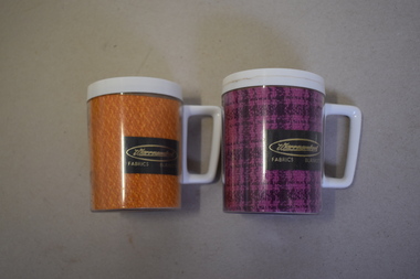 Warrnambool and District Historical Society Inc.
Mugs, Newlyne Mfg. Co Pty Ltd, Warrnambool Fabric Blankets, Mid 20th century
These mugs are souvenirs of the Warrnambool Woollen Mill. They were either sold as souvenirs or given to clients of the mill. The Warrnambool Woollen Mill in South Warrnambool was opened in 1910 with the first manager being John Bennett, an Englishman who recruited skilled weavers and bought mill equipment from his home country. At the height of production the mill was employing up to 700 people. In 1958 the mill became the first in Australia to manufacture electric blankets. In 1968 the mill was sold to the Dunlop company and in the ensuing years various companies owned the plant. In the year 2000 the mill was closed and the equipment was sold. The buildings were sold to a private developer and the first residents moved into the new housing estate in 2009. These mugs are of interest as mementoes of the Warrnambool Woollen Mill, a key industry in the development of Warrnambool and one that operated for 90 years. .1 This is an insulated plastic mug with a mottled orange-coloured body and a white rim on the top opening and a white handle. On the side of the mug is a printed name with gold lettering on a brown background. The maker’s name is etched into the base of the mug. .2 This is an insulated plastic mug with a purple and black mottled body and a white rim on the top opening and a white handle. On the side of the mug is a printed name on a brown background with gold lettering. The maker’s name is etched into the base of the mug. .1 & .2 Warrnambool Fabrics Blankets Steditemp Insulated Ware Made in Australia by Newlyne MFG Co Pty Ltd Division of J. Glaser & Co Melbourne warrnambool woollen mill -
 Eltham District Historical Society Inc
Photograph (Item) - Print, S. Durtodi, Untitled (Vacant Lot with For Sale sign), 1988
S. Durtodi 1988 Entrant No. 76 Ref: Series 34, Items 27, 97 SHIRE OF ELTHAM COMMUNITY PHOTOGRAPHIC SURVEY Photography is an artform which many of us practice, sometimes purely for artistic pursuit, sometimes to record the people and events in our lives. In 1988, as part of a local Bicentennial project, the Shire of Eltham conducted the Eltham Community Photographic Survey. Up to 100 entries were to be selected by a panel of photographers for entry into the Eltham Photographic Survey Exhibition. Entries had to be submitted by May 13, 1988. Entrants whose images were selected for the exhibition were contacted and requested to further submit an entry form providing entrant’s name, area of residence, age, and proposed captions. These details were then used to produce labels for the exhibition mounts. Where negatives had not been supplied, these were requested to support the display of printed enlargements mounted on 10” x 8” cardboard. The mounted prints were made available post exhibition for sale at $8.50 each for colour prints and $7.00 for B&W prints. Residents in the Shire were invited to collect a free roll of film and take a photograph of what they either liked or did not like about the area. A total of 160 entrants submitted multiple entries for the exhibition. Of those selected for exhibition, entrants ranged in age from 9 to 70 years. All custom colour and black and white printing for the exhibition was completed by Wattle Studios of Eltham. The Eltham Photographic Survey was jointly auspiced by the Shire of Eltham and Wattle Studios, of 953 Main Road, Eltham. The project was greatly assisted by: • David McRitchie, Media Studies Lecturer Victoria College, Rusden Campus. • Ian and Annette Toohill of Wattle Studios • Tracy Naughton, Eltham Community Arts Officer • Neville Emerson Pty. Ltd. • Superior Press, Eltham • Kodak Australasia Pty. Ltd. • Agfa Gevaert Ltd. • Townsend Colourtech Pty. Ltd. • The Australian Bicentennial Authority • Eleanor Bowers, Secretary, Eltham Arts Council The exhibition was placed on display in the Woolworths Arcade, Eltham between Monday June 6th and Saturday June 11, 1988. It was also intended to hold the exhibition at a venue in the Shire’s North Riding from Monday, June 20 to Friday June 24. It was then displayed at the Were Street Theatre, Montmorency from Friday, June 24 to Thursday, July 7. Series 34: Eltham Community Photographic Survey 1988 - Prints & Documentation Series consists of 117 photographs of Shire scenes taken by members of the community. Items I - 41 are larger photographs mounted on card, which were exhibited. Items 42 - 117 are unmounted copies, alternative takes and other entries. Corresponding negatives contained in Series 35: Eltham Community Photographic Survey 1988 – Negatives which consists of 267 colour and B&W negatives and one colour slide of Shire scenes taken by members of the community. The negatives are arranged by the entrant number of the photographer. The Eltham Community Photographic Survey collection is significant to the local community as it was curated by the local community - ordinary people of all ages - representing what they liked and did not like in the area where they lived. It represents an unfiltered representation of the Shire of Eltham as it was in 1988. It also represents one of many projects as part of the national programme of events and celebrations to commemorate the bicentenary. It is a time capsule of life in the 1980s of this urban and rural municipality in Melbourne's north. Front: Entrant No. and name on printed label Rear: Entrant No., name and address on printed label; also 'Series 34' and the 'Item No.' in pencilshire of eltham archives, bicentennial project, eltham, eltham community photographic survey, eltham photographic survey exhibition, series 34, series 35, film - ilford hp5, housing estate, real estate advertisement, real estate development, s. durtodi, scan - 35mm negative -
 Eltham District Historical Society Inc
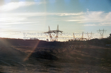
Photograph (Item) - Print, Angela Wall, New Subdivision - Reynolds Road, 1988
Angela Wall 1988 Entrant No. 129 Ref: Series 34, Items 30, 101, 102 SHIRE OF ELTHAM COMMUNITY PHOTOGRAPHIC SURVEY Photography is an artform which many of us practice, sometimes purely for artistic pursuit, sometimes to record the people and events in our lives. In 1988, as part of a local Bicentennial project, the Shire of Eltham conducted the Eltham Community Photographic Survey. Up to 100 entries were to be selected by a panel of photographers for entry into the Eltham Photographic Survey Exhibition. Entries had to be submitted by May 13, 1988. Entrants whose images were selected for the exhibition were contacted and requested to further submit an entry form providing entrant’s name, area of residence, age, and proposed captions. These details were then used to produce labels for the exhibition mounts. Where negatives had not been supplied, these were requested to support the display of printed enlargements mounted on 10” x 8” cardboard. The mounted prints were made available post exhibition for sale at $8.50 each for colour prints and $7.00 for B&W prints. Residents in the Shire were invited to collect a free roll of film and take a photograph of what they either liked or did not like about the area. A total of 160 entrants submitted multiple entries for the exhibition. Of those selected for exhibition, entrants ranged in age from 9 to 70 years. All custom colour and black and white printing for the exhibition was completed by Wattle Studios of Eltham. The Eltham Photographic Survey was jointly auspiced by the Shire of Eltham and Wattle Studios, of 953 Main Road, Eltham. The project was greatly assisted by: • David McRitchie, Media Studies Lecturer Victoria College, Rusden Campus. • Ian and Annette Toohill of Wattle Studios • Tracy Naughton, Eltham Community Arts Officer • Neville Emerson Pty. Ltd. • Superior Press, Eltham • Kodak Australasia Pty. Ltd. • Agfa Gevaert Ltd. • Townsend Colourtech Pty. Ltd. • The Australian Bicentennial Authority • Eleanor Bowers, Secretary, Eltham Arts Council The exhibition was placed on display in the Woolworths Arcade, Eltham between Monday June 6th and Saturday June 11, 1988. It was also intended to hold the exhibition at a venue in the Shire’s North Riding from Monday, June 20 to Friday June 24. It was then displayed at the Were Street Theatre, Montmorency from Friday, June 24 to Thursday, July 7. Series 34: Eltham Community Photographic Survey 1988 - Prints & Documentation Series consists of 117 photographs of Shire scenes taken by members of the community. Items I - 41 are larger photographs mounted on card, which were exhibited. Items 42 - 117 are unmounted copies, alternative takes and other entries. Corresponding negatives contained in Series 35: Eltham Community Photographic Survey 1988 – Negatives which consists of 267 colour and B&W negatives and one colour slide of Shire scenes taken by members of the community. The negatives are arranged by the entrant number of the photographer. The Eltham Community Photographic Survey collection is significant to the local community as it was curated by the local community - ordinary people of all ages - representing what they liked and did not like in the area where they lived. It represents an unfiltered representation of the Shire of Eltham as it was in 1988. It also represents one of many projects as part of the national programme of events and celebrations to commemorate the bicentenary. It is a time capsule of life in the 1980s of this urban and rural municipality in Melbourne's north. Front: Entrant No. and name on printed label Rear: Entrant No., name and address on printed label; also 'Series 34' and the 'Item No.' in pencilshire of eltham archives, bicentennial project, eltham, eltham community photographic survey, eltham photographic survey exhibition, series 34, series 35, angela wall, film - kodak ga 100 5095, housing estate, power transmission lines, real estate development, research (vic.), reynolds road, scan - 35mm negative, subdivison lots -
 Eltham District Historical Society Inc
Photograph (Item) - Print, Sean Brady, Untitled (New Subdivision), 1988
Sean Brady 1988 Entrant No. 145 Ref: Series 34, Items 33, 34, 105, 106 SHIRE OF ELTHAM COMMUNITY PHOTOGRAPHIC SURVEY Photography is an artform which many of us practice, sometimes purely for artistic pursuit, sometimes to record the people and events in our lives. In 1988, as part of a local Bicentennial project, the Shire of Eltham conducted the Eltham Community Photographic Survey. Up to 100 entries were to be selected by a panel of photographers for entry into the Eltham Photographic Survey Exhibition. Entries had to be submitted by May 13, 1988. Entrants whose images were selected for the exhibition were contacted and requested to further submit an entry form providing entrant’s name, area of residence, age, and proposed captions. These details were then used to produce labels for the exhibition mounts. Where negatives had not been supplied, these were requested to support the display of printed enlargements mounted on 10” x 8” cardboard. The mounted prints were made available post exhibition for sale at $8.50 each for colour prints and $7.00 for B&W prints. Residents in the Shire were invited to collect a free roll of film and take a photograph of what they either liked or did not like about the area. A total of 160 entrants submitted multiple entries for the exhibition. Of those selected for exhibition, entrants ranged in age from 9 to 70 years. All custom colour and black and white printing for the exhibition was completed by Wattle Studios of Eltham. The Eltham Photographic Survey was jointly auspiced by the Shire of Eltham and Wattle Studios, of 953 Main Road, Eltham. The project was greatly assisted by: • David McRitchie, Media Studies Lecturer Victoria College, Rusden Campus. • Ian and Annette Toohill of Wattle Studios • Tracy Naughton, Eltham Community Arts Officer • Neville Emerson Pty. Ltd. • Superior Press, Eltham • Kodak Australasia Pty. Ltd. • Agfa Gevaert Ltd. • Townsend Colourtech Pty. Ltd. • The Australian Bicentennial Authority • Eleanor Bowers, Secretary, Eltham Arts Council The exhibition was placed on display in the Woolworths Arcade, Eltham between Monday June 6th and Saturday June 11, 1988. It was also intended to hold the exhibition at a venue in the Shire’s North Riding from Monday, June 20 to Friday June 24. It was then displayed at the Were Street Theatre, Montmorency from Friday, June 24 to Thursday, July 7. Series 34: Eltham Community Photographic Survey 1988 - Prints & Documentation Series consists of 117 photographs of Shire scenes taken by members of the community. Items I - 41 are larger photographs mounted on card, which were exhibited. Items 42 - 117 are unmounted copies, alternative takes and other entries. Corresponding negatives contained in Series 35: Eltham Community Photographic Survey 1988 – Negatives which consists of 267 colour and B&W negatives and one colour slide of Shire scenes taken by members of the community. The negatives are arranged by the entrant number of the photographer. The Eltham Community Photographic Survey collection is significant to the local community as it was curated by the local community - ordinary people of all ages - representing what they liked and did not like in the area where they lived. It represents an unfiltered representation of the Shire of Eltham as it was in 1988. It also represents one of many projects as part of the national programme of events and celebrations to commemorate the bicentenary. It is a time capsule of life in the 1980s of this urban and rural municipality in Melbourne's north. Front: Entrant No. and name on printed label Rear: Entrant No., name and address on printed label; also 'Series 34' and the 'Item No.' in pencilshire of eltham archives, bicentennial project, eltham, eltham community photographic survey, eltham photographic survey exhibition, series 34, series 35, scan - 35mm negative, film - kodak ga 100 5095, housing estate, power transmission lines, real estate development, sean brady, subdivison lots -
 Eltham District Historical Society Inc
Photograph (Item) - Negative, Jocelyn Zepter-Trevor, Eltham Community Photographic Survey Entry, 1988
Jocelyn Zepter-Trevor 1988 Entrant No. 69 Ref: Series 34, Item 24 The images in this record were not selected for inclusion. SHIRE OF ELTHAM COMMUNITY PHOTOGRAPHIC SURVEY Photography is an artform which many of us practice, sometimes purely for artistic pursuit, sometimes to record the people and events in our lives. In 1988, as part of a local Bicentennial project, the Shire of Eltham conducted the Eltham Community Photographic Survey. Up to 100 entries were to be selected by a panel of photographers for entry into the Eltham Photographic Survey Exhibition. Entries had to be submitted by May 13, 1988. Entrants whose images were selected for the exhibition were contacted and requested to further submit an entry form providing entrant’s name, area of residence, age, and proposed captions. These details were then used to produce labels for the exhibition mounts. Where negatives had not been supplied, these were requested to support the display of printed enlargements mounted on 10” x 8” cardboard. The mounted prints were made available post exhibition for sale at $8.50 each for colour prints and $7.00 for B&W prints. Residents in the Shire were invited to collect a free roll of film and take a photograph of what they either liked or did not like about the area. A total of 160 entrants submitted multiple entries for the exhibition. Of those selected for exhibition, entrants ranged in age from 9 to 70 years. All custom colour and black and white printing for the exhibition was completed by Wattle Studios of Eltham. The Eltham Photographic Survey was jointly auspiced by the Shire of Eltham and Wattle Studios, of 953 Main Road, Eltham. The project was greatly assisted by: • David McRitchie, Media Studies Lecturer Victoria College, Rusden Campus. • Ian and Annette Toohill of Wattle Studios • Tracy Naughton, Eltham Community Arts Officer • Neville Emerson Pty. Ltd. • Superior Press, Eltham • Kodak Australasia Pty. Ltd. • Agfa Gevaert Ltd. • Townsend Colourtech Pty. Ltd. • The Australian Bicentennial Authority • Eleanor Bowers, Secretary, Eltham Arts Council The exhibition was placed on display in the Woolworths Arcade, Eltham between Monday June 6th and Saturday June 11, 1988. It was also intended to hold the exhibition at a venue in the Shire’s North Riding from Monday, June 20 to Friday June 24. It was then displayed at the Were Street Theatre, Montmorency from Friday, June 24 to Thursday, July 7. Series 34: Eltham Community Photographic Survey 1988 - Prints & Documentation Series consists of 117 photographs of Shire scenes taken by members of the community. Items I - 41 are larger photographs mounted on card, which were exhibited. Items 42 - 117 are unmounted copies, alternative takes and other entries. Corresponding negatives contained in Series 35: Eltham Community Photographic Survey 1988 – Negatives which consists of 267 colour and B&W negatives and one colour slide of Shire scenes taken by members of the community. The negatives are arranged by the entrant number of the photographer. The Eltham Community Photographic Survey collection is significant to the local community as it was curated by the local community - ordinary people of all ages - representing what they liked and did not like in the area where they lived. It represents an unfiltered representation of the Shire of Eltham as it was in 1988. It also represents one of many projects as part of the national programme of events and celebrations to commemorate the bicentenary. It is a time capsule of life in the 1980s of this urban and rural municipality in Melbourne's north. shire of eltham archives, bicentennial project, eltham, eltham community photographic survey, film - agfa xr 100 i, housing estate, jocelyn zepter-trevor, real estate development, scan - 35mm negative, series 35, road construction, house, magpies -
 Eltham District Historical Society Inc
Photograph (Item) - Negative, Angela Wall, Petrie Park, Montmorency, 1988
Angela Wall 1988 Entrant No. 129 Ref: Series 34, Items 30 The images in this record were not selected for inclusion. SHIRE OF ELTHAM COMMUNITY PHOTOGRAPHIC SURVEY Photography is an artform which many of us practice, sometimes purely for artistic pursuit, sometimes to record the people and events in our lives. In 1988, as part of a local Bicentennial project, the Shire of Eltham conducted the Eltham Community Photographic Survey. Up to 100 entries were to be selected by a panel of photographers for entry into the Eltham Photographic Survey Exhibition. Entries had to be submitted by May 13, 1988. Entrants whose images were selected for the exhibition were contacted and requested to further submit an entry form providing entrant’s name, area of residence, age, and proposed captions. These details were then used to produce labels for the exhibition mounts. Where negatives had not been supplied, these were requested to support the display of printed enlargements mounted on 10” x 8” cardboard. The mounted prints were made available post exhibition for sale at $8.50 each for colour prints and $7.00 for B&W prints. Residents in the Shire were invited to collect a free roll of film and take a photograph of what they either liked or did not like about the area. A total of 160 entrants submitted multiple entries for the exhibition. Of those selected for exhibition, entrants ranged in age from 9 to 70 years. All custom colour and black and white printing for the exhibition was completed by Wattle Studios of Eltham. The Eltham Photographic Survey was jointly auspiced by the Shire of Eltham and Wattle Studios, of 953 Main Road, Eltham. The project was greatly assisted by: • David McRitchie, Media Studies Lecturer Victoria College, Rusden Campus. • Ian and Annette Toohill of Wattle Studios • Tracy Naughton, Eltham Community Arts Officer • Neville Emerson Pty. Ltd. • Superior Press, Eltham • Kodak Australasia Pty. Ltd. • Agfa Gevaert Ltd. • Townsend Colourtech Pty. Ltd. • The Australian Bicentennial Authority • Eleanor Bowers, Secretary, Eltham Arts Council The exhibition was placed on display in the Woolworths Arcade, Eltham between Monday June 6th and Saturday June 11, 1988. It was also intended to hold the exhibition at a venue in the Shire’s North Riding from Monday, June 20 to Friday June 24. It was then displayed at the Were Street Theatre, Montmorency from Friday, June 24 to Thursday, July 7. Series 34: Eltham Community Photographic Survey 1988 - Prints & Documentation Series consists of 117 photographs of Shire scenes taken by members of the community. Items I - 41 are larger photographs mounted on card, which were exhibited. Items 42 - 117 are unmounted copies, alternative takes and other entries. Corresponding negatives contained in Series 35: Eltham Community Photographic Survey 1988 – Negatives which consists of 267 colour and B&W negatives and one colour slide of Shire scenes taken by members of the community. The negatives are arranged by the entrant number of the photographer. The Eltham Community Photographic Survey collection is significant to the local community as it was curated by the local community - ordinary people of all ages - representing what they liked and did not like in the area where they lived. It represents an unfiltered representation of the Shire of Eltham as it was in 1988. It also represents one of many projects as part of the national programme of events and celebrations to commemorate the bicentenary. It is a time capsule of life in the 1980s of this urban and rural municipality in Melbourne's north. shire of eltham archives, bicentennial project, eltham community photographic survey, angela wall, eltham, film - kodak ga 100 5095, housing estate, power transmission lines, real estate development, research (vic.), reynolds road, scan - 35mm negative, series 35, subdivison lots -
 Eltham District Historical Society Inc
Photograph (Item) - Negative, Sean Brady, Untitled (New Subdivision), 1988
Sean Brady 1988 Entrant No. 145 Ref: Series 34, Items 33, 34, 105, 106 The images in this record were not selected for inclusion. SHIRE OF ELTHAM COMMUNITY PHOTOGRAPHIC SURVEY Photography is an artform which many of us practice, sometimes purely for artistic pursuit, sometimes to record the people and events in our lives. In 1988, as part of a local Bicentennial project, the Shire of Eltham conducted the Eltham Community Photographic Survey. Up to 100 entries were to be selected by a panel of photographers for entry into the Eltham Photographic Survey Exhibition. Entries had to be submitted by May 13, 1988. Entrants whose images were selected for the exhibition were contacted and requested to further submit an entry form providing entrant’s name, area of residence, age, and proposed captions. These details were then used to produce labels for the exhibition mounts. Where negatives had not been supplied, these were requested to support the display of printed enlargements mounted on 10” x 8” cardboard. The mounted prints were made available post exhibition for sale at $8.50 each for colour prints and $7.00 for B&W prints. Residents in the Shire were invited to collect a free roll of film and take a photograph of what they either liked or did not like about the area. A total of 160 entrants submitted multiple entries for the exhibition. Of those selected for exhibition, entrants ranged in age from 9 to 70 years. All custom colour and black and white printing for the exhibition was completed by Wattle Studios of Eltham. The Eltham Photographic Survey was jointly auspiced by the Shire of Eltham and Wattle Studios, of 953 Main Road, Eltham. The project was greatly assisted by: • David McRitchie, Media Studies Lecturer Victoria College, Rusden Campus. • Ian and Annette Toohill of Wattle Studios • Tracy Naughton, Eltham Community Arts Officer • Neville Emerson Pty. Ltd. • Superior Press, Eltham • Kodak Australasia Pty. Ltd. • Agfa Gevaert Ltd. • Townsend Colourtech Pty. Ltd. • The Australian Bicentennial Authority • Eleanor Bowers, Secretary, Eltham Arts Council The exhibition was placed on display in the Woolworths Arcade, Eltham between Monday June 6th and Saturday June 11, 1988. It was also intended to hold the exhibition at a venue in the Shire’s North Riding from Monday, June 20 to Friday June 24. It was then displayed at the Were Street Theatre, Montmorency from Friday, June 24 to Thursday, July 7. Series 34: Eltham Community Photographic Survey 1988 - Prints & Documentation Series consists of 117 photographs of Shire scenes taken by members of the community. Items I - 41 are larger photographs mounted on card, which were exhibited. Items 42 - 117 are unmounted copies, alternative takes and other entries. Corresponding negatives contained in Series 35: Eltham Community Photographic Survey 1988 – Negatives which consists of 267 colour and B&W negatives and one colour slide of Shire scenes taken by members of the community. The negatives are arranged by the entrant number of the photographer. The Eltham Community Photographic Survey collection is significant to the local community as it was curated by the local community - ordinary people of all ages - representing what they liked and did not like in the area where they lived. It represents an unfiltered representation of the Shire of Eltham as it was in 1988. It also represents one of many projects as part of the national programme of events and celebrations to commemorate the bicentenary. It is a time capsule of life in the 1980s of this urban and rural municipality in Melbourne's north. shire of eltham archives, bicentennial project, eltham community photographic survey, booth court, eltham, film - kodak ga 100 5095, griffin court, housing estate, power transmission lines, real estate development, reynolds road, scan - 35mm negative, sean brady, series 35, subdivison lots, woodhaven estate -
 Glen Eira Historical Society
Newsletter - Curraweena Avenue Development, Caulfield South
Two copies of a two page Community Cabinet Newsletter, Glen Eira, Issue 8, 10/2002, announcing a joint project to house the elderly at Curraweena Avenue, Caulfield South. The newsletter also announces new funding for ethnic seniors’ groups including the Greek Senior Citizens’ Association of St Gregorios in Bentleigh. The newsletter includes two black and white photographs (54mm x 60mm; 54mm x 125mm).state government, city of glen eira, caulfield south, south caulfield, curraweena avenue, aged people, accommodation, public housing, home units, parliamentary representatives, residential development, pike bronwyn, briggs betty, bentleigh senior citizens’ centre, pandazopoulos john, bracks steve, grants, greek senior citizens’ association, st gregorios bentleigh -
Glen Eira Historical Society
Frogmore Estate
A black and white photograph (140mm x 90mm) of a real estate advertisement for the sale of housing blocks on the residential development Frogmore Estate, Murrumbeena. The advertisement includes a plan showing the location of the housing blocks and the surrounding roads.murrumbeena, carnegie, frogmore estate, neerim road, gnarwyn road, coorigil road, moonya road, woornack road, rosstown railway, carool road, warina road, murrumbeena road, frogmore road, wahgoo road, hethersett grove, hethersett, thomas, j g, plans, housing estates, rosstown, caulfield council, land subdivision -
Glen Eira Historical Society
Document - Beauville Estate
... Residential development Tennis courts Housing estates Builders ...Promotional material for the Beauville Estate Murrumbeena 65th Heritage Celebration held 10/03/2001. This comprises, a leaflet about the launch of the Glen Eira Heritage Draft Guidelines with features of the Estate and addresses listed, a special invitation to the unveiling of the heritage plaque by Glen Eira Mayor Veronika Martens, and a Leader newspaper advertisement dated 12/02/2001 for the event, giving brief history of shops and resident anecdotes by Bev Baxter of Murrumbeena Pharmacy.beauville estate, murrumbeena, lindsay avenue 40-44 (even), 229-233 murrumbeena road, beaville avenue, gloucester court, dalny road 5-25 (north side only), 232-242 murrumbeena road (even), glen eira heritage draft guidelines, murrumbeena pharmacy, a v jennings, 227-235 murrumbeena road, barker ann, martens veronica, baxter bev, heritage festivals, plaques, quinn miss, webb rosemary, webb roy, cleave edna may, quirk john, quirk eva, ritchie, kirkbride thomas, beauville, glen eira port phillip pulse small business awards 2000, architectural features, brick houses, shops, residential development, tennis courts, housing estates, builders, building regulations, local government, commercial development, children’s playgrounds, advertisements, invitations, pharmacies, grocers, dentists, greengrocers, butchery shops, sweet shops -
Glen Eira Historical Society
Document - Beauville Estate
... Residential development Tennis courts Housing estates Builders ...Beauville Estate Draft Heritage Guidelines, July 2000, produced by the Glen Eira City Council, author unknown, 25 pages. The Guidelines set out design parameters, principles and techniques for achieving appropriate heritage conservation objectives for the defined Beauville Estate Heritage Area, to be used by the Council, property owners, residents and designers. A number of photographs of houses and design features are included in the document as well as a brief history of the Estate and a Key Design Checklist.a v jennings construction co, gurney edward, jennings albert v sir, beauville estate, beauville estate heritage area, beauville avenue 1-39 (odd), beauville avenue 2-36 (even), dalny road 3-25 (odd), gloucester court 1-3 (odd), gloucester court 2-6 (even), lindsay avenue 40-44 (even), murrumbeena road 227-233 (odd), murrumbeena road 222-232 (even), murrumbeena, glen eira city council, architectural features, architectural styles, plans, brick houses, shops, residential development, tennis courts, housing estates, builders, building regulations, local government, commercial development, history, maps, photographs -
 Eltham District Historical Society Inc
Film - Video (VHS), Phil Burke et al, Shire of Eltham Grants Commsission Submission (Series 69, Item 7), 1993
Shire of Eltham Archives: Series 69, Item 7 Opens with aerial views of the Shire, 85% of the shire covered by the Green wedge principal. Discusses the obligations required of the Shire to maintain the Green Wedge. The Shire covers over 27,000 hectares with a population in excess of 45,000 residents, more than 70% living in the southern 10% of the Shire in suburbs of Eltham, Montmorency, Lower Plenty and Research. 85% of the Shire in the more sparsely populated northern area which is covered by the Green Wedge. Council is committed to providing a parity of services to all residents such as garbage collection and maintenance of roads. Views of rubbish collection trucks in Montmorency. It is emphasised that the cost of these services in highly populated areas is relatively low whereas in the sparsely populated Green Wedge areas, considerable. There are hundreds of kilometres of roads throughout the Shire, many unmade and maintenance is high to check overhanging trees and erosion especially on the steep hills is expensive and disproportionate to servicing the population in the dense urban areas. Shows views of hilly gravel roads and graders at work maintaining them. Shows scenes of assessing planning applications in these rural areas which takes significantly more time as well as other services provided such as Meals on Wheels, building permits, Ranger services. Provision of recreational facilities in hilly areas requires the acquisition of expensive river flats (views of cricket ground surrounded by hills) and where not possible, costly earthmoving required. Also, views highlighting extensive tracks of natural habitat home to significant bird, animal and plant life. Shire emphasises its commitment highlighted by the Eltham Copper Butterfly which the Shire maintains small pockets of bushland to ensure its survival at significant expense (views of Pauline Toner Copper Butterfly Reserve.) Short interview with Pat Vaughan, Environmental Officer for the Shire discussing the Eltham Copper Butterfly who also mentions many other species in the Shire of high significance from bats to mammals to plants as well as the importance of the Green Wedge to Melbourne – the lungs of Melbourne - and ensuring the protection of very important habitat which requires a great deal of planning and management to look after. Views of Wingrove Park to emphasise this maintenance by machinery in some areas is too damaging and introduced species, etc must be removed by hand. Balancing the services and facilities expected by the community with the needs of the environment requires careful planning demands requires careful planning and the principals of the Green Wedge require constant attention in the face of growing need for housing. Director of Planning & Environment, Richard Allen advises there are approximately 1,300 planning permits and development applications each year ranging from simple subdivision, boundary realignments to further complicated non-urban developments for agricultural pursuits and the level of expertise required from architectural and engineering to land degradation, flora and fauna. Video finishes with aerial views and parklands, streetscapes and rural areas. VHS Video cassette Converted to MP4 file format 00:07:39; 89MBshire of eltham, video recording, shire of eltham archives, eltham shire council, eltham, building permits, cricket ground, development applications, eltham copper butterfly, garbage collection, graders, green wedge, lower plenty, meals on wheels, montmorency, pat vaughan, pauline toner reserve, planning applications, planning permits, ranger services, recreational facilities, research, richard allen, roads, rural areas, wingrove park, victoria grants commission -
 Eltham District Historical Society Inc
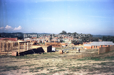
Slide - Photograph, Development either side of Railway Road viewed from across Railway Parade, Eltham, c.Nov. 2001
Part of a slide show presentation "A Trip Down the Diamond Creek" by Russell Yeoman to the Eltham District Historical Society meeting of 14 Nov. 200135mm colour positive transparency Mount - Black and Whiteeltham north, housing estate, railway parade, railway road, eltham -
 Eltham District Historical Society Inc
Document - Newspaper clipping, "The lap of luxury; Blending into Eltham environ", Property Age, The Age, Wednesday 24 June 1998, p5, June 1998
Both of the architects involved in the 2.4-hectare Kinloch Gardens parkland development in Arthur Street, Eltham, are now living on the estate. The project was conceived by Eltham architect Ian Jelbart, whose family has owned the land for more than 100 years, and fellow architect Graeme Gunn, who in the 1960s was one of the creators of the Merchants Builders concept that set new trends in Melbourne housing. The $5 million project is based around two of the original buildings, on what was once a 100-hectare farm owned by the Jelbart family. Ian Jelbart always intended to continue living in the original homestead building, and now Graeme Gunn has moved into the big residence that once was the barn. Kinloch Gardens is designed to combine the more manageable land sizes increasingly demanded by buyers with ample "internal space, flexible floorplans, privacy and individuality of designs. Individual houses are placed on small separate allotments around an area of private parkland. The aim is to ensure total privacy, offer virtually unlimited views and parkland vistas, and remain aesthetically compatible with the local environment. Homes in four basic designs over either two or three levels are being sold off the plan, with prices ranging from the high $200,000s to the high $300,000s. Two have already been sold. Indication of land-only values The prices being asked for some vacant blocks offered for private sale provides an enlightening comparison of the relative "land only" values for homes sites in various areas. A 751 sq metre block on a new residential estate in Bentleigh/Carnegie is offered at $235,000, equivalent to $312/square metre; while in Merrett Drive, Williamstown, a 561 sq metre allotment offered for $169,000 carries a rate of $301/sq metre. In Barnsbury Road, Balwyn, the $450,000 price tag on a 584 sq metre allotment equates to $770 sq metre; and in York Street, Richmond, a 198 sq metre postage stamp is priced at $230,000 or $1162/sq metre. - Rex BookerDigital file only; created from scan undertaken by EDHS of item on loanarthur street, eltham, graeme gunn, houses, ian jelbart, jelbart property, kinloch gardens, rob maclellan, robert marshall, woodridge estate -
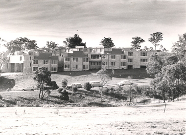
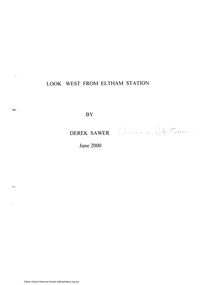 Eltham District Historical Society Inc
Document - Folder, Look West from Eltham Station by Derek Sawer, June 2000
Folder no 65 of the Harry Gilham collection. Reminscences writiten by Peter Sawer, also known as Peter Sawer about living in Eltham after the war from 1945 in the development west of the railway station known as Highbrow Hill. Preface written by Diana Bassett-Smith5 pagesharry gilham collection, reminiscences, derek sawer, peter sawer, diana bassett-smith, john harcourt, housing -
 Federation University Historical Collection
Photograph - Black and White Photographs, Views of Mount Helen Campus, c1973
Ongoing photgraphic record of Mount Helen Campus development. A contract for the construction of Student housing, Union building (later Albert Coates Complex), and a four storey library (later E.J.. Barker Library) on the Mt Helen campus was signed in November and December 1971. They were all completed and occupied in 1973. Views of Mount Helen Campus .1) Signposts of first turnoff campus road from Gear Avenue .2) Mount Helen Student Residences (stage 1) .3) Rear view of Mount Helen Student Residences (Stage 1)mount helen campus, buildings, student residences -
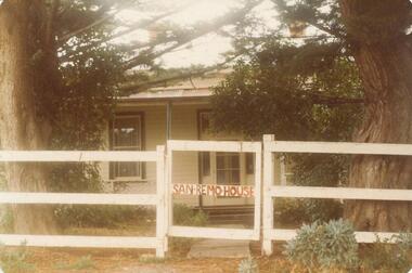 Phillip Island and District Historical Society Inc.
Photograph, 1880's
... housing coloured photograph commercial development san remo ...San Remo house built by Charles Grayden 1880? Possibly Miss Elms' home.Coloured photograph of front of house behind two Cypress Pines - post and rail fence across foreground.San Remo house in red on gatelocal history, photography, photographs, slides, film, san remo, local area development by europeans, housing, coloured photograph, commercial development san remo, dwellings -
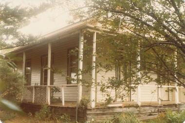 Phillip Island and District Historical Society Inc.
Photograph, 1880's
... remo local area development by europeans housing coloured ...San Remo house built by Charles Grayden 1880?? Possibly Miss Elms' house.coloured print - side view of weatherboard painted white/cream. Verandah with slender square posts - framed by Pine Tree on left and small leafed tree on right.local history, photography, san remo, local area development by europeans, housing, coloured photograph, commercial development san remo, domestic development -
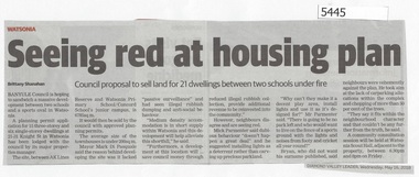 Greensborough Historical Society
Newspaper Clipping, Diamond Valley Leader, Seeing Red at Housing Plan, 16/05/2018
Banyule Council is hoping to sandwich a massive development between two schools and a sports oval in Watsonia.News article 1 page, black text.watsonia, knight street watsonia, concord school, watsonia primary school, residential development, banyule city council