Showing 327 items
matching location plan
-
 Bendigo Historical Society Inc.
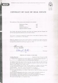
Document - PETER ELLIS COLLECTION: CONTRACT OF SALE
... , Planning Certificate Request for Building Approval Particulars... Information Certificate, Planning Certificate Request for Building ...Copy of Contract of Sale of Real Estate and associated papers for property located in Flora Lane, Flora Hill which was purchased by Peter Ellis on 26 May 1993. Contract is in booklet with other loose papers. Contract includes General Conditions, Particulars of Sale, Special Conditions, Guarantee, Vendors Statement to the Purchaser, Shire of Strathfieldsaye Land Information Certificate, Planning Certificate Request for Building Approval Particulars, Coliban Region Water Authority Information Statement, Property Inquiry Application Form, Request for Property Information from Vic roads, Advice on Mine Subsidence Hazard (Department of Energy & Minerals), Map, Copy of Certificate of Title and Folder Numbers. Loose pages include Building Control Act 1981 Inspection Notice, two plans of building, Three plans (Coliban Water Asset Location) of Flora Lane where property is situated, 2 dated 13/11/2007 (have New Carport drawn beside house) and 1 dated 22/11/2007. Last page has specifications for car port.bendigo, house, peter ellis oam, peter ellis collection, reiv, law institute of victoria, real estate institute of victoria ltd, e j gannaway, peter n ellis, ray white bendigo pty ltd, e m monotti & son, rogers and every, craig watts, shire of strathfieldsaye, coliban region water authority, sec, g & fc of vic, telecom, vicroads, bruce l phillips, k deps?, department of energy and minerals, robert james sanderson, t flanagan, land titles office victoria, harston partridge & co pty ltd -
 Bendigo Historical Society Inc.
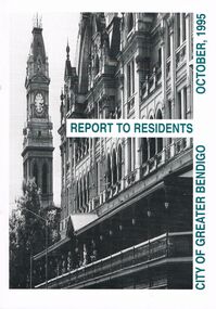
Book - BOOKLET: ''REPORT TO RESIDENTS CITY OF GREATER BENDIGO, OCTOBER 1995''
Front cover is a photo of The Shamrock Hotel. 52 paged booklet - ''Report to Residents - City of Greater Bendigo, October 1995''. Table of Contents; Commissioners; Chief Executive Officer; Council meetings; Office location and hours; ''One Telephone Number''; Committees; Ward boundaries; Elections; Customer services; Rural services; Economic development; Bendigo Tourism Board; Bendigo Trust; Events Bendigo; Capital works 1995/96; Major projects; Discovery; Bendigo Regional Arts Centre; local laws; Fire prevention; Aged and disability services; Children and family services; Environmental health; Recreation and leisure; Parks and gardens; Planning and building; Waste management; Library services; Bendigo Leisureland; Rates; Budget for 1995/96; Index. Contains some photographs and map of proposed 7 internal Wards for the City of Greater Bendigo.Richard Cambridge Printers Bendigo.bendigo, council, report, maxine crouch, maurie sharkey, perer ross-edwards, peter seamer, hadley sides, richard morriss, bernard smith, annie galvin child care centre, bendigo regional art centre, rosalind park, budget 1995/96. bendigo health care services. -
 Bendigo Historical Society Inc.
Plan - Great Extended Hustlers, April, 2014
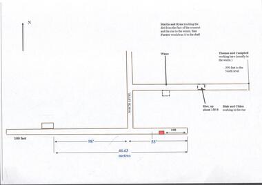
Seven men were killed at the Great Extended Hustler's mine disaster on 2nd May 1914 by an explosion of dynamite occurring as the men were waiting at the plat to ascend the mine at the end of their shift. No blame was attached to anyone in the findings of the inquisition. It was unknown what caused the dynamite to explode. This document formed part of the research done at the time by Bendigo Historical Society, of the 100 years commemoration of the mine disaster, held at Hustler's Hill in 2014. One page plan, computer generated, annotated to show the worksite of the miners prior to when the explosion occurred at the Great Extended Hustlers mine in May 1914. The location of Martin, Ryan, Thomas, Campbell, Blair and Chinn are described. great extended hustlers, goldmining, accident, 1914 -
 Bendigo Historical Society Inc.
Map - STRUGNELL COLLECTION: HUSTLER'S LINE OF REEFS, September 1913
Map, Hustler's Line of Reefs, Hustler's Reef & Hustler's Reef No.1 Mines Plan.Plate No. XV1.(16) Sheet 2 .Bulletin No 33 Signed H.A.Whitelaw.Underground Survey Office, Bendigo, September,1913. Included is the emblem of the Geological Survey of Victoria. Drawing shows a plan view of reefs and shaft locations .Underground Survey Office, Bendigomap, bendigo, hustler's reef & hustler's reef 1 -
 Bendigo Historical Society Inc.
Map - J W SWATTON COLLECTION: MAPS
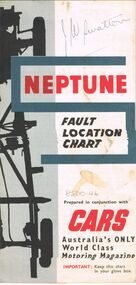
Seven maps of various sizes. Map of the City of Ballarat, Victoria, Road Condition Map of Victoria including Melbourne-Cairns & Melbourne-Adelaide, Neptune Fault Location Chart, Grampians District Map, Racv Tour Planning Map Showing Road Conditions for Victoria, NSW and Queensland and Mt Macedon & District. Two of the maps have J W swatton & J Swatton written on them.j w swatton collection, racv, mobil, neptune, a r blair, j ewins & sons pty ltd, berry anderson & co -
 Bendigo Historical Society Inc.
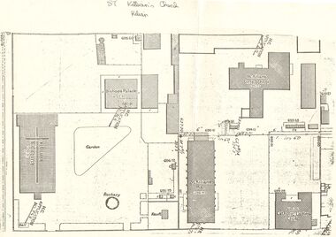
Document - PLAN OF THE AREA SURROUNDING: ST. KILIAN'S CHURCH
Plan of area surrounding St. Kilian's Church showing location of church, Bishop's Palace, and Vault, position of the Bell,. St. Kilians Girls School, St. Kilians Hall and the Catholic Ladies Club building. Plan is over stamped in a number of places with ''H.C. Application No 765'' and appears to have spot heights and indication of slope in two places (''I in 60''). No indication on plan of scale of plan. No date.church, history, st. kilian's catholic church, bendigo, bishops palace, ladies club building, st kilian's hall. -
 Bendigo Historical Society Inc.
Document - CENTRAL DEBORAH GOLD MINE: MINES ALONG THE DEBORAH ANTICLINE
Plan of reef line showing the location of the Deborah Gold Mines. Drawn by Philip Wilkin for the 60th anniversary of the closing of the Central Deborah Gold Mine.bendigo, mining, deborah gold mines, deborah gold mines -
 Bendigo Historical Society Inc.
Document - DEBORAH REEF PROJECT ENVIRONMENT EFFECTS STATEMENT
Two page document. On top, first page ' Bendigo Mining N.L., Deborah Reef Project, Environment Effects Statement, Summary Brochure'. Poppet head on top LH corner of document. A map of central Bendigo is drawn on page 1 and shows the location of the proposed processing plant near the Airport. Further maps on page 2 and 3 show the North Deborah Mine Site, the pipeline route and the airfield site. The summary brochure provides an outline of the material contained in the Environment Effects Statement and proposed planning scheme amendments upon which, the Deborah Reef Project will be assessed. Page four lists the issues that impact on this submission: planning and land use; socio economic environment; traffic; discharges to air; water management; explosives storage and handling; subsidence; heritage; flora and fauna and landscape and visual assessment. The 16th March, 1989, is the date given for submissions to be lodged in regard to this project.Bendigo Mining N.Lbendigo, mining, deborah reef project -
 Bendigo Historical Society Inc.
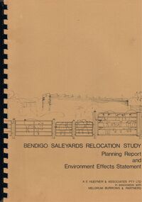
Book - BENDIGO SALEYARDS COLLECTION: BENDIGO SALEYARDS RELOCATION STUDY - PLANNING REPORT AND ENVIRONMENT
Bendigo Saleyards Relocation Study - Planning Report and Environment Effects Statement for the City of Bendigo by A E Huefner & Associates Pty Ltd in association with Meldrum Burrows & Partners. Book has a light brown cover with black plastic binder spine. Green and yellow pages separate some sections. The front cover has a sketch of a stock transport with a pig, sheep and cattle behind gates. Contents include: Introduction, Summary, Recapitulation on the Feasibility Report which includes The Need for Action, the Site and Existing Uses Adjacent to the Site, The Proposal which includes Concept, Project Description, Components, Siting of Facilities, Land Clearing, Earthworks, Darainage, Buildings and Structures, Roads and Pavements, Services, Landscaping, Soil Profile and Construction Programme. Invironmental Effects which include Visual Impact Dust, Odours, Effluent, Effluent Treatment System, Traffic, Artificial Lighting, Noise, Operational Failures and Nature Conservation Effects. Statutory Planning Considerations which includes Zoning Controls and Suggested Procedure for Initiating I.D.O. Amendment. Appendices are: A.- Copy of Tit;e, B - Soil Investigation, C - Acoustic Assessment and D - Suggested Draft Amendment to Shire of Marong I.D.O. Contains a photo of the area - View of the Site, looking South and a number of drawings. Copies of various Council Reports referring to the Saleyards Relocation Project. It has a bright yellow cover and a hard plastic type spine. Mentioned in the reports is the cost to bring the old saleyards up to standard and list of improvements. Reports are as at 16th July, 1984. Mustard coloured book with plastic spine titled Bendigo Saleyards Relocation Study Feasibility Report by Meldrum Burrows & Partners in association with A E Huefner & Associates Pty Ltd and Acil Australia Pty Ltd dated September, 1983. Items mentioned are: Introduction, Summary, Background, Role in Livestock Marketing for the Bendigo Saleyards (Acil Australia Pty. Ltd., Saleyard Relocation: Strategic Considerations, Financial Implications and Conclusion. Appendix 1: Estimation of Livestock Population in Catchment Area. Drawings in Fig 1 Existing Bendigo Saleyards and Surrounding Land Uses, Fig 2 Catchment Area for Bendigo Saleyards 1983, Fig 4.1 Estimated Sheep Populatiuon in Catchment Area 1976 - 77 to 1981 - 82, Fig 4.2 Estimated Cattle Population in Catchment area 1976 -77 to 1981 -82, Fig 3 Possible Saleyard Relocation Areas, Fig 4, Directions from which access to possible Saleyard Locations would be obtained - Estimated percentage of sheep to cattle stock, Fig 5 Possible Saleyard Locations - Northern Area, Fig 6 Possible Locations of Saleyards - Inner West, Fig 7 Possible Locations of Saleyards - Outer West. Considerations were made as to renovate the existing saleyards or to move them elsewhere. Effluent, transport and stock movement, and condition of the yards were a problem.bendigo, council, cattle markets, bendigo saleyards collection - bendigo saleyards relocation study - planning report and environment effects statement, a e huefner & associates pty ltd, meldrum burrows & partners, city of bendigo, state electricity commission, mal styles, bendigo college of advanced education, n j fieldew, pryce goodale & duncan pty ltd, p b swift, shire of marong -
 Bendigo Historical Society Inc.
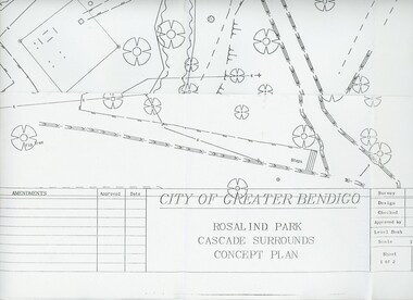
Plan - MERLE HALL COLLECTION: ROSALIND PARK CREATIVE VILLAGE BENDIGO PROJECT CONCEPT PLAN, 1993
MERLE HALL COLLECTION: ROSALIND PARK CREATIVE VILLAGE BENDIGO PROJECT Concept Plan City of Greater Bendigo Rosalind Park Cascade Surrounds Concept Plan number GB095 Sheet 1 of 2 Level Book 365, Backup No Tape 01, Computer File No. ROS QEO. Large Sheet which shows the location of utilities, vegetation, drains, embankments etc. June 1993 -
Bendigo Historical Society Inc.
Document - VICTORIA HILL - VICTORIA HILL AND NEW CHUM HILL
Typed notes on Victoria Hill and New Chum Hill. Notes give location, value of gold and plans for a mining museum.document, gold, victoria hill, victoria hill, victoria hill and new chum hill, john neil macartney, the age, the australasian, bendigo goldfields registry 1871, victoria reef quartz mine, north old chum, victoria consols, new chum and victoria, pioneer, lansell 222 mine, lazarus, barnet lazarus, mt. alvernia hospital, fortuna villa, george lansell, a. h. q. survey regiment, central red white and blue, hudsons, burrowes & sterry, b c v channel 8, bendigo and district tourist association, section 14 of the lands act 1958, mr a r richardson, cr t r flood, tourist association -
 Bendigo Historical Society Inc.
Document - PLAN SHOWING THE VARIOUS CLAIMS ON THE NEW CHUM VICTORIA , ST MUNGO & DEVONSHIRE REEFS BENDIGO
Map of mines - calico scroll showing locations of various claims .printed in black ink on off-white Calico with turned wooden ends on scroll -missing one wooden end , some stains and creasing / Plan showing the various Claims on the New Chum Victoria , St Mungo & Devonshire reefs BendigoW Holmes , printer & lithographer , Sandhurstorganization, mining, industrial, w holmes , printer & lithographer , sandhurst/new cum , victoria st mungo & devonshire reefs bendigo -
 Bendigo Historical Society Inc.
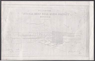
Document - VICTORIA REEF GOLD MINES COMPANY BENDIGO PLAN
Photocopy of a Plan of the Victoria Reef Gold Mines Company, Bendigo. Shaded area is the Victoria Reef Gold Mines Company Lease No. 2 and Lease No. 3. The gullies are named Happy Valley, Long, Derwent, Providence and Ironbark Gullies. The reefs are: Western Victoria, Victoria, Eastern Victoria and Prince Albert Reef. Between the Eastern Victoria Reef and the Prince Albert Reef is the White Lead. Mount Korong Road is at the bottom of the plan. Other Leaseholders are: Burrows, Wybrant, Ballerstedt, Jackson,Roberts & Co, Ashley, Grant, ?rpe, ?eau, Woodward, Coath, Taylor, Cranshaw, Roberts, Gould & Co, Midway, Witscheibe, Endeavour Co, Albert Co, Ballerstedt & Son, Late Iron Bark Quartz Mining Co, McDougall, Specimen Hill Co, Hygrect?, Wheadon, Evans and Bannerman. Signed by H. B. Nicholas. Location of Ballerstedt, Luffsman, Midway Co, Witscheibe and Rae & Co engine locations. Hills are shown as hatch shading. Written at the bottom left ocrner is: Accompanying prospectus issued in Nov. 1859. Signed H.B. Nicholas.plan, bendigo, victoria reef gold mines company, victoria reef gold mines company bendigo - plan, h b nicholas, burrows, wybrant, ballerstedt, jackson, roberts & co, ashley, grant, ?rpe, ?eau, woodward, coath, taylor, cra-shaw, roberts, gou-d & co, midway, witscheibe, endeavour co, albert co, ballerstedt & son, late iron bark quartz mining co, mcdougall, specimen hill co, hyo?, wheadon, evans, bannerman. -
 Bendigo Historical Society Inc.
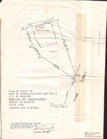
Document - CROWN ALLOTMENT 406A (PLAN) JOSS HOUSE
Plan of Survey of part of Crown Allotment 406A Sec E. City of Bendigo. Parish of Sandhurst. County of Bendigo. Scale 1:500. (Copy of Original). As at 21 February 1979. This survey shows the location of the Joss House and the portion of land where it is located.plan, bendigo, joss house, crown allotment 406a (plan), joss house -
Bendigo Historical Society Inc.
Document - VICTORIA HILL - PLAN OF THE VICTORIA REEF GOLD MINES COMPANY
Plan of the Victoria Reef Gold Mines Company, Bendigo showing the Eastern Victoria Reef, Victoria Reef and the Western Victoria Reef. Streets, gullies and leases drawn in. Some amounts of money and names have been written on the page. Signed by H. B. Nicholas. Locations of Ballerstedt's, Luffsman's, Wittscheibe's, Midway Co and Rae's engines are shown. Ironbark, Derwent, Providence and Long Gullies are shown. Also Mount Korong Road. Leases mentioned are: Jackson, Burrows, Wybarndt, Ballerstedt, Luffsman, Roberts, Ashley, Grant, Troy, Tezeau, Woodward, Croath, Taylor, Cranshaw, Gou?d & Co, Midway, Wittscheibe, Specimen Hill Co,Endeavour, Albert Co, Ballerstedt & Son, Hy? Co, and Wheadon.document, gold, victoria hill, victoria hill, plan of the victoria reef gold mines company, h b nicholas, spiers, jackson, burrows, wybarndt, ballerstedt, luffsman, roberts, ashley, grant, troy, tezeau, woodward, croath, taylor, cranshaw, gou?d & co, midway, wittscheibe, specimen hill co, endeavour, albert co, ballerstedt & son, hy? co, and wheadon -
 Bendigo Historical Society Inc.
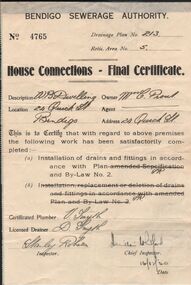
Document - L. PROUT COLLECTION: BENDIGO SEWERAGE AUTHORITY
Bendigo Sewerage Authority. Receipt No. 4765 - Drainage plan No. 213, retic. Area No. 5. house Connections Final Certificate. Location 24 Quick street, Bendigo - Owner Miss l. Prout. This is to certify that with regard to the above premises the following work has been satisfactorily completed: installation of drains and fittings in accordance with plan and by-law no.2organization, public utility, water -
 Bendigo Historical Society Inc.
Document - CONSERVATORY BUILDING
7 page document on the building and various relocations of the Conservatory building first erected in the Melbourne Botanic Gardens in 1880 and used as a Palm House. Other locations: Melbourne Zoo 1940 Werribee Zoo 1970 CoGb 2001 - gifted for White Hills Botanic ardens Included in the Bendigo Botanic Gardens Master plan as a long term action for reconstruction.bendigo, buildings, conservatory bendigo botanic gardens -
 Bendigo Historical Society Inc.
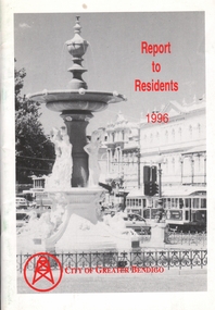
Book - BOOKLET: REPORT TO RESIDENTS CITY OF GREATER BENDIGO, 1996
Front cover is a photo of Alexandra Fountain. 52 paged booklet - ''Report to Residents - City of Greater Bendigo, 1995. Table of Contents; The Mayor; Chief Executive Officer; Council meetings; Office location and hours; ''One Telephone Number''; Locations of functions and business; Units; Organisation Structure; Advisory Committee; Municipal Boundaries; Customer services; Economic development; Bendigo Tourism; Bendigo Trust; Events Bendigo; Capital works 1996/97; Bendigo Regional Arts Centre; Local laws; Aged and disability services; Children and family services; Environmental health; Recreation and leisure; Parks and gardens; Planning and building; Waste management in Bendigo; Library services; Rates; Budget for 1996/97; The budget at a glance; Index.bendigo, council, report -
Bendigo Historical Society Inc.
Map - HUSTLER'S ROYAL RESERVE NO 2 MINE - PLAN OF THE HUSTLER'S ROYAL RESERVE NO 2 MINE
Plan of the Hustler's Royal Reserve No 2 Mine Bulletin No 33, Plate No V. Plan shows the Hustler's Royal Reserve No 2 (Main Shaft), Hustler's Royal Reserve No 2 (Park Shaft.), the Royal Hustler's, the Imperial Hustler's and the Extended Hustler's Freehold on the Hustler's Line of Reefs. Also mentioned is the Lightning Hill Line of Reefs. Map shows some of the levels, approximate boundary of lease and the boundary of Lease No 8892 and 8897. There are also street names and the locations of jail, lagoons, Post Office, Rosalind Park and the State School, High School and Continuation School. Geological Survey of Victoria emblem. H. Herman Director, W. Dickson, Secretary of Mines and The Hon. J. Drysdale Brown MLC, Minister of Mines. Signed by zh Whitdan, Underground Survey Office, Bendigo, September 1913.mining, parish map, hustler's royal reserve no 2 mine, plan of the hustler's royal reserve no 2 mine, hustler's royal reserve no 2 (main shaft), hustler's royal reserve no 2 (park shaft), royal hustler's, imperial hustler's, extended hustler's freehold, geological survey of victoria, h herman, w dickson, the hon j drysdale brown, h whitdan, hustler's line of reefs, lightning hill line of reefs -
Bendigo Historical Society Inc.
Document - HERCULES AND ENERGETIC MINES - NOTES ON THE HERCULES AND ENERGETIC MINES
Four typed copies of notes on the Hercules and Energetic Mines. Notes include Location, depth of shafts, plant and machinery, Early History and Prominence. Reference: Mines Dept Special Edition Australian Mining Standard 1.6.1899, Mines Dept Booklet Bendigo Goldfield 1936, Mines Dept Annual and Quarterly Reports, Annals of Bendigo Mining Sections 1876 - 1921, A Richardson, The Bendigo Goldfield Registry J N Macartney 1.3.1871, Mines Dept Bulletin No 30 h Herman 1914, Bendigo Amalgamated Goldfields Coy Financial Reports 1920.mine, gold, hercules and energetic mines, hercules and energetic mines, notes on the hercules and energetic mines, the hercules, the energetic, the north energetic, the victoria pilot, plan of leases of 1870, bendigo amalgamated goldfields company, sheepshead line, wheat owl, central blue, big blue, mines dept special edition australian mining standard 1.6.1899, mines dept booklet bendigo goldfield 1936, mines dept annual and quarterly reports, annals of bendigo mining sections 1876 - 1921, a richardson, the bendigo goldfield registry j n macartney 1.3.1871, mines dept bulletin no 30 h herman 1914, bendigo amalgamated goldfields coy financial reports 1920 -
Bendigo Historical Society Inc.
Document - LANSELL'S BIG 180 MINE - CONDENSED HISTORICAL RECORD OF LANSELL'S BIG 180 MINE
Two handwritten and three typed copies of a Condensed Historical Record of Lansell's Big 180 Mine on the New Chum Line of Reef. Notes include location, shaft, first worked, size of lease, plant, engine house, boiler rooms, mullock heap, early history, Prominent, best gold, underground connections, pressurised hot water, diamond drill bores and a table with depths and the increase in temperature with the depth (in Fahr).document, gold, lansell's big 180 mine, lansell's big 180 mine, condensed historical record of lansell's big 180 mine, wittscheibe, ballerstadt, ernst mueller, theodore ballerstadt, george lansell, north old chum, victoria quartz, mines dept special edition 'australian mining standard' 1/6/1899, mines dept booklet 'bendigo goldfield' 1936, quarterly reports, lansell's 180 mine 'transverse sections, annals of bendigo mining sections, a richardson's observations from old photographs and measurements of mining plans, measurements taked from caleb thomas' report mines dept 1875, 'report on observation of underground temperature at bendigo' james stirling government geologist 1899, a richardson -
Bendigo Historical Society Inc.
Map - LANSELL'S BIG 180 MINE - LOCALITY OF LANSELL'S NO 180 SHAFT
Buff coloured photocopy of the location of Lansell's No 180 Shaft and showing the positions of Underground Workings near the intersection of Lily St and Alley St. Also mentioned are the North Old Chum Shaft and the New Chum and Victoria Co Shaft. Luffman Brothers has been written in in pen and initialled A R. Printed at the bottom is: Surveyed by E. T. Brown, under the direction of A. W. Howitt, Secretary for Mines for the - (the rest is cut off).map, bendigo, mining plan, lansell's big 180 mine, locality of lansell's no 180 shaft, north old chum co shaft, new chum and victoria co shaft, luffman brothers, e t brown, a w howitt -
Bendigo Historical Society Inc.
Map - NEW CHUM & VICTORIA LINES OF REEF - PLAN OF NEW CHUM & VICTORIA LINES OF REEF
Two pages of a Plan of New Chum & Victoria Lines of Reef, compiled by G. W. Hart. Taken from J. N. Macartney's G'Fields Registry for 1871. Plan shows leases from High Street to California Gully. Location of the Manchester Arms, British & American Hotel and the Quartz Miners Arms are shown. Townships of Long Gully and Ironbark are shown.map, goldfields, new chum & victoria lines of reef, plan of new chum & victoria lines of reef, victoria catharine g m coy, thornton & co, extd victoria reef g m co, ural tribute compy, nil desperandum compy, koch, north victoria g m co, danger hill coy, north endeavour coy, wheadon & co, pilot co, north energetic co, energetic compy, endeavour company, hercules co, victoria gold mines compy, iron duke g m co, golden fleece united, ballerstedt, alfred co, confidence co, prince alfred co, canterbury co, advance co, wells, humboldt co, adventure co, try me well, sterry & co, gibbs & ballerstedt, handy andy, wells?, south adventure co, w rae, victoria reef quartz m co, myra co, jackson, wybrants, burrows & sterry, new chum & victoria tribute, old chum co, ballerstedt, lazarus, watson, koch & hildebrand, lansell & hunt, dennis, abe lincoln co, bonati & co, ellesmere co, moore late menzies, british co, british tribute co, garibaldi, c c co, new chum trib, dobson & co, young chum co, little chum co, old chum co, new chum trib, little chum trib, g w hart, j n macartney's g'fields registry for 1871, manchester arms, british & american, quartz miners arms -
Bendigo Historical Society Inc.
Document - RAE'S CRUSHING BATTERY - THE RICH VICTORIA HILL & ITS HISTORICAL ASSOCIATIONS
The first five pages are photocopies of photos:- 2 of Rae's Crushing Works; Victoria Quartz on Victoria Hill, Ironbark; Looking North from Old Chum Hill to the Victoria Hill; Victoria Hill - from Rae's Open Cut. Introduction covers location of buildings and mines. Mentioned are:- North Old Chum Mine, Ballerstedt's First Open-cut, Quartz Veins (Spurs), rock formations pitching North, Prospecting shafts 1929, Concrete dam, Engine beds of Lansells Big 180 Mine, Lansells Big 180 Shaft, twenty stampers crushing battery, Lansell's Cleopatra Needle type chimney, Victoria Quartz Mine, Victoria Quartz dams, Rae's Open-cut, Quartz once roasted here to an intense heat, Anticlinal Arch New Chum Line, small primitive tunnels, Prospecting tunnels, Floyd's small 5 head crushing battery, Great Central Victoria (Midway) Shaft, Great Central Victoria engine-bed, Ballerstedt's small 24 yard claim, The Humboldt, Adventure ground, The Advance, Luffsman & Sterry's Claim, A round shaft. Small piece of paper with 'Notes on Victoria Hill complete.document, gold, rae's crushing battery, rae's crushing battery, rae's crushing works, victoria quartz mine, from old chum hill, victoria hill from rae's open cut, ironbark, hercules & energetic, midway, wittscheibe, great central victoria, mr & mrs conroy, central nell gwynne, gold mines hotel, john brown knitwear factory, new chum & victoria, rotary club of bendigo south, north old chum, ballerstedt's first open-cut, lansell's big 180 shaft, cleopatra needle type chimney, a roberts & sons, mr e j dunn, h harkness & sons, eureka extd, new chum railway, pearl, inrush of water at victoria quartz, floyd's small 5 head crushing battery, great central victoria (midway), ballertedt's small 24 yard claim, humboldt, humboldt, great central victoria, victoria hill, bendigo & vicinity 1895 p51, j n macartney 1st edition 1871, bendigo goldfield registry 1871, plan of new chum line, mr rae anderson, annals of bendigo obituary 1904, bendigo advertiser, b m l records mines dept, patterson's goldfields of victoria, dickers mining record 23/11/1861, australian mining standard special edition 1/6/1899 p40, bendigo mines ltd, chinese joss house, fortuna, the victoria goldfield 1851 to 1954, the victoria hill 1854 to 1949 -
 Bendigo Historical Society Inc.
Document - MCCOLL, RANKIN AND STANISTREET COLLECTION: NAPOLEON REEF GOLD MINING CO. N.L, 1940
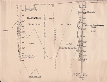
... Document: 4 copies of plan of Transverse Section... mining gold mining Napoleon Reef Document: 4 copies of plan ...Document: 4 copies of plan of Transverse Section of Napoleon Anticline Lease no 10970, plan shows proposed shaft location and depth (1000 ft), for Napoleon Reef Gold Mining Co, also location and depth of adjacent Central Nell Gwynne Shaft scale 100ft = 1 inch, Prepared by J.J. Caldwell Mines Dept Bendigo.organization, business, industrial - mining, mccoll rankin & stanistreet, mining, gold mining, napoleon reef -
Bendigo Historical Society Inc.
Map - BIG 180 SHAFT POSITION, No date visible
... Map: Plan showing the location of various shafts...: Plan showing the location of various shafts in the Victoria ...Map: Plan showing the location of various shafts in the Victoria Hill area, hand draughted in pencil. Scale 2 Chains to 1 inchmap, bendigo, mining plan, mining , gold mines. victoria hill, big 180 -
Bendigo Historical Society Inc.
Map - PLAN OF THE BENDIGO RAILWAY YARD, Circa 1960
Map: Plan of the Bendigo Railway Yards, Scale: 80 feet to 1 inch. 1960's. (number 319 in map cupboard 1) Location unknown. Image in Mosaic images overflow.map, bendigo, railway yard, railways, rail yards, station layout