Showing 599 items matching "lookouts"
-
 Kew Historical Society Inc
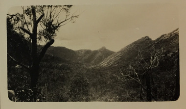
Photograph - Grampians, 1924
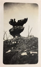
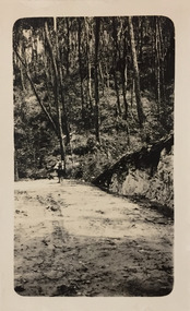
Henry Beater Christian (1886-1962) , was a descendant of one of the earliest settler families in Kew. Employed at the Kew Asylum as a 'public servant', he was a skilled amateur photographer, photographing numerous scenes in Kew and on his travels around Victoria. The majority of his photographs date from 1916 to 1929. His finest photographs are housed in two photograph albums. Digital copy of a photograph from page 12 of the 47-page photograph album containing 261 gelatinous silver images, loaned by Diane Washfold with permission given to digitise and hold a copy in our collection. The first and last pages in the album document the Yarra River at Studley Park and at Kew. The remainder of the album includes photographs of walking and car tours in rural Victoria including 'wilderness' areas in the Grampians, Gippsland and the High Country. Six album pages document a camping trip by Henry Christian to the Grampians in September 1924. The photos include pictures of lookouts, and natural features including rock faces and waterfalls, as well as his camp site. This photo is of a self-standing rock on what is probably the Mt Victory trail. "Mt Victory / Grampians / 9.24"henry beater christian (1886-1962), landscape photography, christian-washfold collection, photograph albums, grampians, mt victory, gariwerd -
 Kew Historical Society Inc
Photograph - Grampians, 1924
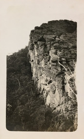
Henry Beater Christian (1886-1962) , was a descendant of one of the earliest settler families in Kew. Employed at the Kew Asylum as a 'public servant', he was a skilled amateur photographer, photographing numerous scenes in Kew and on his travels around Victoria. The majority of his photographs date from 1916 to 1929. His finest photographs are housed in two photograph albums. Digital copy of a photograph from page 13 of the 47-page photograph album containing 261 gelatinous silver images, loaned by Diane Washfold with permission given to digitise and hold a copy in our collection. The first and last pages in the album document the Yarra River at Studley Park and at Kew. The remainder of the album includes photographs of walking and car tours in rural Victoria including 'wilderness' areas in the Grampians, Gippsland and the High Country. Six album pages document a camping trip by Henry Christian to the Grampians in September 1924. The photos include pictures of lookouts, and natural features including rock faces and waterfalls, as well as his camp site. This photo is of one of a well-known cliff face on one of the walking trails. Unitled [Grampians]henry beater christian (1886-1962), landscape photography, christian-washfold collection, photograph albums, grampians, mt victory, gariwerd -
 Kew Historical Society Inc
Photograph - Grampians, 1924
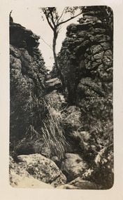
Henry Beater Christian (1886-1962) , was a descendant of one of the earliest settler families in Kew. Employed at the Kew Asylum as a 'public servant', he was a skilled amateur photographer, photographing numerous scenes in Kew and on his travels around Victoria. The majority of his photographs date from 1916 to 1929. His finest photographs are housed in two photograph albums. Digital copy of a photograph from page 13 of the 47-page photograph album containing 261 gelatinous silver images, loaned by Diane Washfold with permission given to digitise and hold a copy in our collection. The first and last pages in the album document the Yarra River at Studley Park and at Kew. The remainder of the album includes photographs of walking and car tours in rural Victoria including 'wilderness' areas in the Grampians, Gippsland and the High Country. Six album pages document a camping trip by Henry Christian to the Grampians in September 1924. The photos include pictures of lookouts, and natural features including rock faces and waterfalls, as well as his camp site. This photo is of one of opposing rock faces on one of the walking trails. Unitled [Grampians]henry beater christian (1886-1962), landscape photography, christian-washfold collection, photograph albums, grampians, gariwerd -
 Kew Historical Society Inc
Photograph - Grampians, 1924
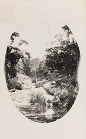
Henry Beater Christian (1886-1962) , was a descendant of one of the earliest settler families in Kew. Employed at the Kew Asylum as a 'public servant', he was a skilled amateur photographer, photographing numerous scenes in Kew and on his travels around Victoria. The majority of his photographs date from 1916 to 1929. His finest photographs are housed in two photograph albums. Digital copy of a photograph from page 14 of the 47-page photograph album containing 261 gelatinous silver images, loaned by Diane Washfold with permission given to digitise and hold a copy in our collection. The first and last pages in the album document the Yarra River at Studley Park and at Kew. The remainder of the album includes photographs of walking and car tours in rural Victoria including 'wilderness' areas in the Grampians, Gippsland and the High Country. Six album pages document a camping trip by Henry Christian to the Grampians in September 1924. The photos include pictures of lookouts, and natural features including rock faces and waterfalls, as well as his camp site. This photo is of a rock pool, developed within an oval framing device."Grampians"henry beater christian (1886-1962), landscape photography, christian-washfold collection, photograph albums, grampians, gariwerd -
 Kew Historical Society Inc
Photograph - Grampians, 1924
Henry Beater Christian (1886-1962) , was a descendant of one of the earliest settler families in Kew. Employed at the Kew Asylum as a 'public servant', he was a skilled amateur photographer, photographing numerous scenes in Kew and on his travels around Victoria. The majority of his photographs date from 1916 to 1929. His finest photographs are housed in two photograph albums. Digital copy of a photograph from page 15 of the 47-page photograph album containing 261 gelatinous silver images, loaned by Diane Washfold with permission given to digitise and hold a copy in our collection. The first and last pages in the album document the Yarra River at Studley Park and at Kew. The remainder of the album includes photographs of walking and car tours in rural Victoria including 'wilderness' areas in the Grampians, Gippsland and the High Country. Six album pages document a camping trip by Henry Christian to the Grampians in September 1924. The photos include pictures of lookouts, and natural features including rock faces and waterfalls, as well as his camp site. This is a photo of local flora on a bushland track in the Grampians, developed within an oval frame."Grampians"henry beater christian (1886-1962), landscape photography, christian-washfold collection, photograph albums, grampians, gariwerd -
 Kew Historical Society Inc
Photograph - Grampians, 1924
Henry Beater Christian (1886-1962) , was a descendant of one of the earliest settler families in Kew. Employed at the Kew Asylum as a 'public servant', he was a skilled amateur photographer, photographing numerous scenes in Kew and on his travels around Victoria. The majority of his photographs date from 1916 to 1929. His finest photographs are housed in two photograph albums. Digital copy of a photograph from page 15 of the 47-page photograph album containing 261 gelatinous silver images, loaned by Diane Washfold with permission given to digitise and hold a copy in our collection. The first and last pages in the album document the Yarra River at Studley Park and at Kew. The remainder of the album includes photographs of walking and car tours in rural Victoria including 'wilderness' areas in the Grampians, Gippsland and the High Country. Six album pages document a camping trip by Henry Christian to the Grampians in September 1924. The photos include pictures of lookouts, and natural features including rock faces and waterfalls, as well as his camp site. This photo is a long distance view of the mountains with trees framing the picture in the foreground. "Grampians"henry beater christian (1886-1962), landscape photography, christian-washfold collection, photograph albums, grampians, mt victory, gariwerd -
 Eltham District Historical Society Inc
Photograph, The Stokes family home and orchard blanketed with snow, corner Nyora and Eucalyptus roads, Eltham, Winter 1951, 1951
Taken from outside the family home on the southest corner of the intersection of Nyora Road and Pitt Street with Eucalyptus Road. Frank Stokes first traveled to the district by train in 1944 to find land with the intention to establish an orchard. By chance he met Arthur Bird of Bird Orchard (bounded by Pitt Street, Eucalyptus Road and Wattle Grove) and they got talking over their common interest. Arthur put Frank up for the night and pointed out the land, part of Crown Allotment 15, Section 5, Parish of Nillumbik (CA15) somewhat diagonally opposite Bird Orchard. Frank bought the land and for the next two years would travel by train from Melbourne to Eltham every weekend establishing Stokes Orchard and building a home for his family, which they eventually moved into in 1946. Marjorie North remembered well the winter of 1951, when she took children, including son John together with the Shallard and Squire children “in the Austin A40 up the Main Rd., Eltham to farmer Bell’s property alongside the Eltham College. They were able to make a snow man and throw snowballs. (Diamond Valley News, August 5, 1986.p.42) In the mid 1970s the Shire of Eltham divided the orchard up into numerous rate-able parcel lots, which became affordable for Frank. As a consequence Stokes Orchard was turned into a housing development by Macquarie Builders and marketed as the Stokes Orchard Estate in two stages; Stage 1 encompassing Scarlet Ash Court, Ironbark Close and Peppermint Grove bounded by Nyora and Eucalyptus roads c.1976 and Stage 2 encompassing Stokes Place, Orchard Way, The Crest and The Lookout bound by Nyora and Diosma roads c.1979. The development of Orchard Way, The Crest and The Lookout did not proceed as planned due to the lack of the sewer along Diosma Road and so many of the proposed lots were incorporated into five-acre parcels instead.Representative of the orchard growing areas of Eltham. One of the rare times it has snowed in Eltham.Digital file only - Digitised by EDHS from a scrapbook (containing commercially printed photos of digital scans) on loan from Beryl Bradbury (nee Stokes), daughter of Frank Stokes.1951, beryl bradbury (nee stokes) collection, eltham, nyora road, eucalyptus road, snow, stokes family home -
 Mt Dandenong & District Historical Society Inc.
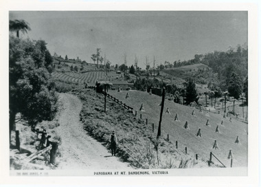
Photograph, View From Corner of Doughty's Road and Barbers Road 1913
John Lundy-Clarke grew up in the Kalorama/Mt Dandenong area and later in life (1972-74) began to write a comprehensive history of the area working from an original settlement map in an effort to cover all areas. Taken c1913, this photograph gives a clear indication of where significant buildings were located in relation to one another. Barbers Road is running through the picture with the guest house 'Kia-Ora' , built by George Barber in the centre. High on the skyline on the left is the 'Mountjoy' guesthouse, indicating the location of The Gap, or FiveWays. The small 'boxy' house above 'Kia-Ora' is 'Iona' built by the Paynter family who also built 'Mountjoy'. The Jeeves property 'Kalorama' is to the right of 'Iona' and this is the area you now look to from the FiveWays Lookout. The man in the photo is wearing a trilby hat so is probably a Rose Series employee - a feature in many Rose Series postcards.Black and white photograph that is a copy of Rose Series Postcard # 156. A man can be seen walking down an unmade road with haystacks to his right. Buildings and crops can be seen on the hillsides. Handwritten inscription on reverse by John Lundy-ClarkeView from corner of Doughty’s and Barbers Road 1913. “Kia Ora” in centre Paynter’s “Iona” near center skyline above “Kia Ora” with “Kalorama” on its right and Peter’s hut of the time below it among orchard trees. “Mountjoy” is on left skyline. W. Haye’s home is centre left. Hay paddock is Barbers Lot 25 Village Settlement.kia-ora, iona, kalorama, mountjoy, guesthouse, guest house, barbers road, doughty's road, paynter, jeeves, george barber -
 Bendigo Historical Society Inc.
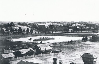
Photograph - LANDSCAPE VIEW OF BENDIGO
Black and white photograph. In foreground, roof and chimneys. Row of 3 small weatherboard houses with verandah, picket fences. 1 small and 1 larger building behind. Lake or dam with small island centre, stone brick wall with lookout tower at corner ( Bendigo gaol ) at right centre distanc,e large building. Benevolent Asylum. Many other buildings in distance. James Lerk 11.2.2000 ' view from the Corporate High School, Benevolent Asylum in centre' Unknown BHS member 5.11.1999 ' lower dam ( site of present tennis courts, Park Road, pumped out C 1926' Written on back of photo 'Bendigo Victoria 1860's, Sandhurst North view 100 miles north from Melbourne. C. Nettleton, Victorian Views'C. Nettleton ?place, landscape view, bendigo -
 Bendigo Historical Society Inc.
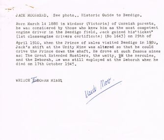
Document - VARIOUS ARTICLES FOR NEWSLETTER ('MARUNARI?) FOR NOVEMBER
Various articles for Newsletter ('Marunari??) for November???? 1. Re Jack Moorhead (''the most competent engine driver in the Bendigo field'') with handwritten copy of same; 2. 3 pages of handwritten notes for inclusion in the newsletter - various topics; 3. ''The Canons (sic) on Camp Hill'' - history of the Lookout Tower site and flag post, cannons and statue - semi-nude lady - which was damaged in storm and later removed. Source of information for this item attributed to Misses D and D Davenpor, London and the Bendigo Advertiser; handwritten notes re this same article. 4. ''Boys will be boys'' by Mr A Richardson - article based on Annual Report of the Secretary for Mines and Water Supply, 1885 re 11 year old lad who fell down mine; handwritten notes on same article.document, names of bendigo pioneers, jack moorhead. -
 Bendigo Historical Society Inc.
Newspaper - THREE UNRELATED ADVERTISER ARTICLES: SIMES (SYMES?) FAMILY: GOLDEN SQUARE RAILWAY STATION: ONE TREE HILL, 01/09/1984
Three unrelated Advertiser articles all dated 1/9/1984 stapled together- Simes (Symes?)family; Golden Square railway station; One Tree Hill. Simes family: Letter asking for help in assistance with information about the Simes family (1905-1924); Golden Square (railway) station buildings - some history of the building but article is about dilemma of old and 'not needed' buildings ''I wonder whether anybody want Golden Square/'' author - Andrew Ward, Bendigo Advertiser; article by John Hattam re the origin of the name ''One Tree Hill'' and history of the cutting down of The Tree (1879 - prosecution of a Jerry Ryan for vandalism); the road to the top being constructed (1892); lookout-tower constructions - the first being in 1894.document, newspaper, old rail stations, golden square rail station -
 Kew Historical Society Inc
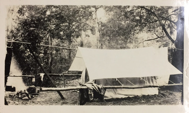
Photograph - Campsite in the Grampians, 1924
Henry Beater Christian (1886-1962) , was a descendant of one of the earliest settler families in Kew. Employed at the Kew Asylum as a 'public servant', he was a skilled amateur photographer, photographing numerous scenes in Kew and on his travels around Victoria. The majority of his photographs date from 1916 to 1929. His finest photographs are housed in two photograph albums. Digital copy of a photograph from page 12 of the 47-page photograph album containing 261 gelatinous silver images, loaned by Diane Washfold with permission given to digitise and hold a copy in our collection. The first and last pages in the album document the Yarra River at Studley Park and at Kew. The remainder of the album includes photographs of walking and car tours in rural Victoria including 'wilderness' areas in the Grampians, Gippsland and the High Country. Six album pages document a camping trip by Henry Christian to the Grampians in September 1924. The photos include pictures of lookouts, and natural features including rock faces and waterfalls, as well as his camp site. This photo is of one of his campsites. The tent, beside which a man is standing, is a simple canvas sheet is supported by saplings and ropes. "Mt Victory / Grampians / 9.24"henry beater christian (1886-1962), landscape photography, christian-washfold collection, photograph albums, grampians, mt victory, gariwerd -
 Kew Historical Society Inc
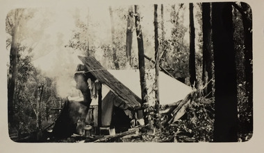
Photograph - Campsite in the Grampians, 1924
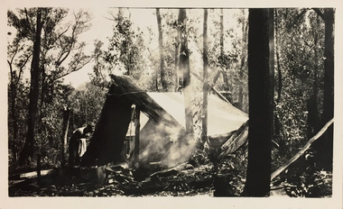
Henry Beater Christian (1886-1962) , was a descendant of one of the earliest settler families in Kew. Employed at the Kew Asylum as a 'public servant', he was a skilled amateur photographer, photographing numerous scenes in Kew and on his travels around Victoria. The majority of his photographs date from 1916 to 1929. His finest photographs are housed in two photograph albums. Digital copy of a photograph from page 15 of the 47-page photograph album containing 261 gelatinous silver images, loaned by Diane Washfold with permission given to digitise and hold a copy in our collection. The first and last pages in the album document the Yarra River at Studley Park and at Kew. The remainder of the album includes photographs of walking and car tours in rural Victoria including 'wilderness' areas in the Grampians, Gippsland and the High Country. Six album pages document a camping trip by Henry Christian to the Grampians in September 1924. The photos include pictures of lookouts, and natural features including rock faces and waterfalls, as well as his camp site. This photo is of a campsite with a pitched tent supported by slabs of bark and ropes. A man is standing in front of the tent partly obscured by the smoke."Grampians"henry beater christian (1886-1962), landscape photography, christian-washfold collection, photograph albums, grampians, mt victory, gariwerd -
 Bendigo Historical Society Inc.
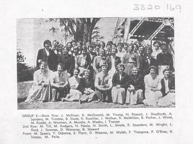
Photograph - LA TROBE UNIVERSITY BENDIGO COLLECTION: BENDIGO TEACHERS' COLLEGE STUDENTS
A black and white photograph of 1955 Bendigo Teachers' College Group E students in front of the Lookout Tower in Rosalind Park. . They are - J. McKean, Ruth McDonald, Maureen Young, Nancy Pascall, Jean Shadforth, Ann? Sanders, Maureen Trimble, Beverley Slade, R. Rawiller, J. Walker, Roma McMillan, Beverley Parker, Jan Wood, Margaret Rodda, Ann Warman, Anne Moodie, Aileen Weeks, Brenda Tranter, Margaret Till, Margaret Rodgers, N. Neale, Nancy Smith, Lorraine Smale, Ruth? Saunders, M. Wright, L. Reid, Jessica Scoones, Dianne? Warsnop, Beverley Stewart, Margaret Speers, Yvonne Osborne, Elaine Plant, D. Wearne, M. Walsh, Fay Trengove, Pat O'Bree, Ruth Stacey, M. Peile. See 3320.100bendigo, education, bendigo teachers' college students, la trobe university bendigo collection, collection, bendigo, education, bendigo teachers' college, students, teacher training, tertiary education, photo, photos, photograph, photographs, history -
 Wodonga & District Historical Society Inc
Photograph - North-Eastern Gold Days, 1900
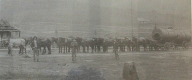
Bethanga was established as a result of the discovery of gold. Gold was first reported in the Bethanga area in 1852. Before 1876 gold mining in the Bethanga district occurred to the north of the town and was known as the 'Talgarno diggings'. Reports of alluvial gold date back to 1852. Early gold fields were worked at Ruby Creek, Gold Creek and Jarvis Creek. The opening of the Bethanga goldfields began with the discovery of a gold-bearing quartz reef on New Year’s Day 1876. The 'Gift' mine site is located southeast of Kurrajong Gap lookout to the west of Bethanga township. The Great Eastern Copper Smelting Works was opened in 1878. Due to the nature of the gold-bearing quartz reef, the gold was difficult to extract, and the discovery of copper led to a change in focus. It was not until the early 1890s that an efficient technique for extracting the gold from the ore was discovered, and once again gold became the focus, with copper as a by-product. Bethanga was removed from the official list of goldfields in 1912, however some mining activity has taken place since.This image reflects an important time in the development of Bethanga and Northeast Victoria.A large mounted and framed image of horse teams and their owners hauling a large boiler to the gold mine near Bethanga, Victoria. On label beneath image: "North-eastern "Gold Days"/ Combined teams hauling a boiler to Bethanga Mines, 1900. Teamsters - Mr. G. Pearce, W. Chapple, G, Bannon." Donated by Ron Saunders and Barbara Cadman"bethanga, gold mining northeast victoria, gold mining bethanga, bethanga history -
 Bendigo Military Museum
Postcard - POSTCARDS, PHOTOGRAPHIC WW1, Daily Mail, c.1914 - 1918
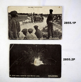
Daily Mail Battle Pictures, Series VII.Seven black & white postcards of aspects of the Great War..1) The glorious first of July 1916 - Our first prisoners, SVII No 49. .2) Star shell bursting near British lines, SVII No 51. .3) Army Chaplain tending British graves, SVII No 52. .4) The Fighting Fifth (Northumberland Fusiliers) after the Battle of St Eloi, SVII No 52. .5) Tommy's lookout in a captured trench at Orvillers, SVII No 52. .6) London Scottish going into their trenches,m SVII No 55. .7) Sir D Haig introducing Sir Pertab Singh to Generall Joffre, SV11 No 49.photography-photographs, military history, passchendaele barracks trust -
 Ballarat Tramway Museum
Postcard - Folder set, Valentine & Sons Publishing Co, "Bendigo Photographic Booklet", 1940's
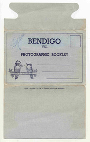
Set of 9 black and white views of Bendigo printed on a folded strip, glued within a light grey colour light weight cardboard folder, titled "Bendigo Photographic Booklet". Booklet printed with an address area with title and kookaburras. Produced by The Valentine Publishing Co. Pty Ltd Melbourne & Sydney The rear has a slit on the rear cover that allowed the folder to be secured. Pictures are: 1. Mitchell St 2. The Lookout Tower 3. Conservatory Gardens 4. Shamrock Hotel 5. The Lake, Upper Reserve 6. The Pall Mall 7. Civic Buildings 8. Soldiers Memorial Hall and Post Office 9. Alexandria Fountain, Bendigo with a single trucker, M class type tram, prior to alterations, but in SEC colour scheme of the mid 1930's Made during 1940, with photographs of the 1930's as well given motor cars in the photo. Has "D. Gilbert" in ink on cover.trams, tramways, bendigo, pall mall, charing cross, mitchell st -
 Kew Historical Society Inc
Photograph - Campsite in the Grampians, 1924
Henry Beater Christian (1886-1962) , was a descendant of one of the earliest settler families in Kew. Employed at the Kew Asylum as a 'public servant', he was a skilled amateur photographer, photographing numerous scenes in Kew and on his travels around Victoria. The majority of his photographs date from 1916 to 1929. His finest photographs are housed in two photograph albums. Digital copy of a photograph from page 12 of the 47-page photograph album containing 261 gelatinous silver images, loaned by Diane Washfold with permission given to digitise and hold a copy in our collection. The first and last pages in the album document the Yarra River at Studley Park and at Kew. The remainder of the album includes photographs of walking and car tours in rural Victoria including 'wilderness' areas in the Grampians, Gippsland and the High Country. Six album pages document a camping trip by Henry Christian to the Grampians in September 1924. The photos include pictures of lookouts, and natural features including rock faces and waterfalls, as well as his camp site. This photo is of one of his campsites. The tent, beside which a man is standing, is a simple canvas sheet held up by ropes and supported at one end by large slabs of bark. "Mt Victory / Grampians / 9.24"henry beater christian (1886-1962), landscape photography, christian-washfold collection, photograph albums, grampians, mt victory, gariwerd -
 Kew Historical Society Inc
Photograph - Grampians, 1924
Henry Beater Christian (1886-1962) , was a descendant of one of the earliest settler families in Kew. Employed at the Kew Asylum as a 'public servant', he was a skilled amateur photographer, photographing numerous scenes in Kew and on his travels around Victoria. The majority of his photographs date from 1916 to 1929. His finest photographs are housed in two photograph albums. Digital copy of a photograph from page 15 of the 47-page photograph album containing 261 gelatinous silver images, loaned by Diane Washfold with permission given to digitise and hold a copy in our collection. The first and last pages in the album document the Yarra River at Studley Park and at Kew. The remainder of the album includes photographs of walking and car tours in rural Victoria including 'wilderness' areas in the Grampians, Gippsland and the High Country. Six album pages document a camping trip by Henry Christian to the Grampians in September 1924. The photos include pictures of lookouts, and natural features including rock faces and waterfalls, as well as his camp site. This is a photo of a man in the distance on a bush track who is looking over his shoulder at the camera. He carries a sack and has a swag on his back. This may be Henry Christian or a companion."Grampians"henry beater christian (1886-1962), landscape photography, christian-washfold collection, photograph albums, grampians, gariwerd -
 Bendigo Historical Society Inc.
Photograph - LA TROBE UNIVERSITY BENDIGO COLLECTION: BENDIGO TEACHERS' COLLEGE STUDENTS
BHS CollectionAn envelope which contained multiple copies of photos of students at Bendigo Teachers' College in 1947, the 1950's and the 1960's. on rear of photo is stamped: Geoff & Pam Pryor, "Langley" 50 Miller Street Bendigo 3550, Tel: (054) 424471. One black and white photograph of Bendigo Teachers' College students in 1947 taken at the base of the Lookout Tower in Rosalind Park Bendigo. One black and white photo of Bendigo Teachers' College students in the 1950's. Man in second row extreme right named as George Vincent. One black and white photograph of Bendigo Teachers' College students in the 1960's. 15 copies of a black and white photo of Bendigo Teachers' College students in the 1960's. Two black and white photos of Bendigo Teachers' College students in the 1960's. 2 copies.bendigo, education, bendigo teachers' college students, la trobe university bendigo collection, collection, photography, photo, photographs, photograph, bendigo teachers' college, male, female, students, education, envelope, bendigo teachers' college students, bendigo, teacher training, tertiary education, history, bendigo teaches' college history -
 Ballarat Heritage Services
Photograph - Photograph - Colour, Kathleen Gervasoni, Red Rock, Alvie, 1989, 02/09/1989
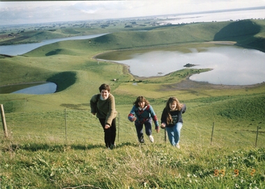
Red Rock, Alvie, near Colac, is a complex of approximately 30 volcanic eruption points and is the Southern most of a chain of three volcanoes, the others being Warrion Hill and Alvie Hill. It is arguably the youngest eruption point in Victoria at around 8000 years, especially since the age of Mt Napier has been progressively pushed back. The highest point (on the Northern side) has many interesting features, including some awesome spatter ramparts. Driving around the rim to the south, you can also see layered tuff. There are some good views out to Lake Corangamite and the lava flows (probably from Warrion Hill) can be seen where they have entered the lake. Most of Red Rock is in private land, with two lookout points with some interpretive information. The water depicted in this photograph is not evident in 2019. Type: Volcanic Complex Location: South of Alvie, Victoria Last Eruption: 8000 years ago Access: Mostly private land, but there is an access road and some interpretive signage Visited: Visited Colour photograph of sisters Clare Gervasoni (left), Ann Gervasoni (centre) and Lisa Gervasoni and Red Rock, Alvie clare gervasoni, lisa gervasoni, ann gervasoni, red rock alvie -
 National Wool Museum
Photograph - Portrait of Joan Lindros, Nicole Marie, 2021
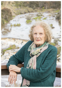
Thousands of volunteers work tirelessly to conserve and protect the environment of Geelong and the Bellarine. Their work often goes unnoticed. In 'The Work of Nature' the National Wool Museum and the Environment Department at the City of Greater Geelong worked with photographer Nicole Marie to showcase the significant contribution of environment volunteers in our region. Each of the eight people showcased in these portraits were nominated by their peers and members of the community for their significant contribution to conserving and protecting the environment. Joan Lindros - Geelong Environment Council Joan Lindros has been a mentor to community environmentalists across the Geelong region and beyond for many years. In 1972 she was a foundation member of the Geelong Environment Council. She was also instrumental in the Save the Otways campaign that resulted in the Great Otway National Park. Joan is an inspirational leader, tenacious advocate and a gentle person. In 2001 she was inducted into the Victorian Honour Role of Women. She continues to be involved in the Friends of Buckley Falls who have been working and advocating for the protection and restoration of the Barwon and Moorabool River Reserves for nearly forty years. Photo at Buckley Falls lookout by Nicole Marie.Image showing an environmental portrait of a woman leaning against wooden railing with trees, a river and a waterfall in the background.environment, conservation, portraits, geelong, nature, exhibition, work of nature, geelong nature forum, volunteers, buckley falls -
 Eltham District Historical Society Inc
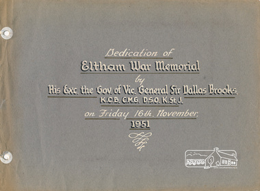
Photo album, Dedication of Eltham War Memorial by His Exc. the Governor of Vic., General Sir Dallas Brooks, K.C.B., C.M.G., D.S.O., K.StJ., on Friday 16th November, 1951, 1952c
On November 11th 1929 the Shire of Eltham War Memorial Tower at Kangaroo Ground was opened. It is regarded as one of Melbourne’s most outstanding lookout towers. It commands a magnificent 360 degree panorama from Kinglake across the Diamond Valley to Macedon and the You Yangs. It is built on a peak which was once a volcano, 237 metres above sea level. After World War one a memorial cairn was erected on the site, and in 1925 a committee of public-minded citizens began to plan for a tower. Many generous donations of material and money were forthcoming so that in 1926 the Governor General Lord Stonehaven was able to unveil the plaque before a crowd of 500 people. There was some concern in the 1960s when the Forests Commission wanted to build a firespotters cabin on the top. At first R.S.L. branches opposed the idea, but it was realised that this use could combine with its use as a tourist attraction, and would ensure its maintenance for the future, Today the Kangaroo Ground tower provides one of the best views around Melbourne and is a fitting memorial to those who died in two world wars. From: Historic items for Diamond Valley Community Radio September 1990 (EDHS collection) Red hard bound binder, 2-ring holder; 18 grey coloured page inserts (3 blank) with 7 photos. Two pages of text in white paint. Also includes inserted leaves of manila card with photocopies of relevant news clippings pasted to card. An additional photo mounted on card dated 1952 has also been inserted into album.eltham, dedication, opening day, sir dallas brooks, kangaroo ground, war memorial, kangaroo ground tower -
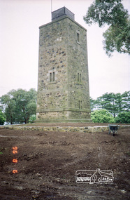 Eltham District Historical Society Inc
Photograph, Shire of Eltham War Memorial Tower, Memorial Park, Garden Hill, Kangaroo Ground Tower, 6 Aug 1996, 1996
On November 11th 1926 the Shire of Eltham War Memorial Tower at Kangaroo Ground was opened. It is regarded as one of Melbourne’s most outstanding lookout towers. It commands a magnificent 360 degree panorama from Kinglake across the Diamond Valley to Macedon and the You Yangs. It is built on a peak which was once a volcano, 237 metres above sea level. After World War one a memorial cairn was erected on the site, and in 1925 a committee of public-minded citizens began to plan for a tower. Many generous donations of material and money were forthcoming so that in 1926 the Governor General Lord Stonehaven was able to unveil the plaque before a crowd of 500 people. There was some concern in the 1960s when the Forests Commission wanted to build a firespotters cabin on the top. At first R.S.L. branches opposed the idea, but it was realised that this use could combine with its use as a tourist attraction, and would ensure its maintenance for the future, Today the Kangaroo Ground tower provides one of the best views around Melbourne and is a fitting memorial to those who died in two world wars. From: Historic items for Diamond Valley Community Radio September 1990 (EDHS collection) Roll of 35mm colour negative film, 7 stripsKodak Gold 100-5garden hill, kangaroo ground memorial, memorial park, shire of eltham war memorial tower, war memorial tower, war memorials -
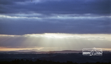 Eltham District Historical Society Inc
Photograph, View of Mount Macedon from the Shire of Eltham War Memorial Tower, Garden Hill, Kangaroo Ground, 1983, 1983
On November 11th 1926 the Shire of Eltham War Memorial Tower at Kangaroo Ground was opened. It is regarded as one of Melbourne’s most outstanding lookout towers. It commands a magnificent 360 degree panorama from Kinglake across the Diamond Valley to Macedon and the You Yangs. It is built on a peak which was once a volcano, 237 metres above sea level. After World War one a memorial cairn was erected on the site, and in 1925 a committee of public-minded citizens began to plan for a tower. Many generous donations of material and money were forthcoming so that in 1926 the Governor General Lord Stonehaven was able to unveil the plaque before a crowd of 500 people. There was some concern in the 1960s when the Forests Commission wanted to build a firespotters cabin on the top. At first R.S.L. branches opposed the idea, but it was realised that this use could combine with its use as a tourist attraction, and would ensure its maintenance for the future, Today the Kangaroo Ground tower provides one of the best views around Melbourne and is a fitting memorial to those who died in two world wars. From: Historic items for Diamond Valley Community Radio September 1990 (EDHS collection) Digital copy of colour photographfred mitchell collection, 1983, kangaroo ground, mount macedon, war memorial tower, shire of eltham war memorial tower -
 Parks Victoria - Gabo Island Lightstation
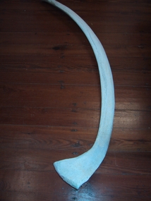
Whale bones
Whale bones found in harbour area. Dr Imlay operated a whaling outpost in Santa Barbara Bay in the early 1800's. John Morris ventured into whaling in 1848. The success of these ventures is not known. Retrieved from the Gabo Island Harbour in 1999, the collection’s two venerable whalebones are reminders of the whaling industry that was associated with Gabo Island prior to construction of the lightstation. Evocative relics of this long ceased activity, they are now also symbolic of today’s concern for protecting and saving whales. The whalebones are the only known artefacts in the collection that illustrate the period when European sealers and whalers intermittently used the island for their activities. The Imlay brothers, who operated from Twofold Bay, Eden NSW, used the island as a base and lookout up until about 1846, and several huts were erected.Whaling was last associated with the island in 1848, when John Morris surreptitiously ventured into this activity while being paid to erect lightstation buildings for the NSW government. Gabo’s historic jetty store, which stands as the oldest structure on the island, was thought to be built by Morris and is possibly associated with the activities that led to his dismissal. The whalebones were recovered from the harbour, close to the location of the store and the site of the former whaling outpost. The bones have first level contributory significance as evidence of the island’s whaling activities, which pre-date the history of the lightstation.1. Whale vertebrae, bleached white. 2. Whale bone, (rib) bleached white. -
 Bendigo Historical Society Inc.
Document - PRESENTATION TO BHS 7TH JULY 2000: ''CAMP RESERVE'', 7th July 2000
Presentation by James Lerk to BHS 7th July 2000: ''Camp Reserve -Rosalind Park, used and abused''. First line: ''This short paper has no pretension in giving a complete synopsis regarding a slice of land which cradles a great deal of the history of Bendigo''. References to Commissioner Gilbert; Bank of Victoria; Bendigo Bank; powder magazine; post office; Survey Office; Court of Petty Sessions; Police Barracks; Supreme Court; Gaol; Temperance Society; Robert Strickland residence; tenements on Reserve; Mac's Track; Orderly Room; Cascades; Corporate High School; Temperance Fire Brigade; Masonic Hall; Central School Camp Hill; Fernery; ''The Willows''; Conservatory; Parade Ground; Sandhurst Club; Police Station; Grandstand in Upper Reserve; High School; Soldiers Memorial Insitutute; Lookout (poppet head - Garden Gully United); Advance Bendigo and North League crèche; Sound Shell; Olympic Swimming Pool. Two printed copies.James Lerk.bendigo, streetscape, camp reserve, rosalind park, bendigo creek -
 Ballarat Tramway Museum
Photograph - Leaf from a photo album, 1920s
Leaf from a photo album containing 4 black and white photographs pasted onto sheet of brown/grey cardboard with two punch holes at one end. Photos taken early 1920's or just after construction of the Memorial Arch. Photo 1 - "Ballarat" handwritten in pencil at top - Town Hall from the North West taken from a building near Doveton St. Has a Sebastopol tram west bound in Sturt St. passing Town Hall. Photo 2 - "Sturt Street Ballarat" handwritten in pencil at base - Sturt St. Ballarat looking east from most likely the Ballarat City fire station lookout tower. Has a Sebastopol tram travelling eastbound in the photograph. Town Hall in background. No motor vehicles in photograph. Photo 3 - "Memorial Arch, Ballarat" handwritten in pencil at top - photo of the new Memorial Arch at the start of the Avenue of Honour. Photo 4 - "Eureka Stockade, Ballarat" - photo of the Eureka Stockade monument the park.trams, tramways, ballarat, sturt st, memorial arch - avenue of honour, eureka -
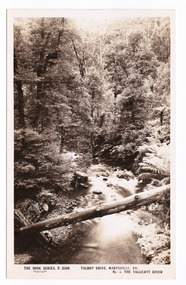 Marysville & District Historical Society
Postcard (item) - Black and white postcard, Rose Stereograph Company, Talbot Drive, Marysville, Vic. No. 3, The Taggerty River, 1913-1967
A postcard in a series produced by the Rose Stereograph Company in Victoria, Australia as a souvenir of Marysville.A black and white photograph taken along Lady Talbot Drive, Marysville, in Victoria, of the Taggerty River. Lady Talbot Drive is a 24 kilometer scenic rainforest car journey which passes a number of walks and waterfalls in the Yarra Ranges National Park. Lady Talbot Drive is named after Lady Sarah Elizabeth, the wife of Sir Reginald Talbot, who was the Governor of Victoria from 25th April, 1904 to 6th July 1908. This postcard was produced by the Rose Stereograph Company as a souvenir of Marysville.POST CARD The "Rose " Series/ De Luxe A Real Photograph/ Produced in Australia Published by the Rose Stereograph Co./ Armadale, Victoria. Dear John,/ I am writing this note in my room/ at Mt. Kitchener House before sallying forth for/ dinner. Unfortunately space does not permit/ me to tell you much, but I must let you know/ that yesterday morning (Monday), a blanket of/ snow covered the township of Marysville to a/ depth of three or four inches. Further up, near/ Keppel's Lookout, which we visited yesterday, it/ was nearly a foot deep everywhere, and it snowed/ the whole time we were walking./ Will tell you all later, your friend, Billtalbot drive, marysville, victoria, taggerty river, p. 2308, rose series postcard, postcard, souvenir, sir reginald talbot, lady sarah elizabeth talbot -
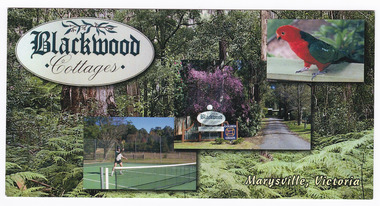 Marysville & District Historical Society
Postcard (Item) - Colour postcard, Blackwood Cottages, Pre 2009
A colour postcard from Blackwood Cottages in Marysville.A colour postcard from Blackwood Cottages in Marysville.12.5.2007 Dear Lorna, Each day is perfect after near/ frost overnight. The colours/ are beautiful - the little/ town seems to glow./ Walked to the Falls on Tuesday/ + saw 3 Lyrebirds - one male/ going through his repetiore of/ local birds./ Yesterday Rod drove me up to/ Lake Mountain where we did/ Look Walk taking in 3 lookouts/ with lovely views./ The cottage is very/ comfortable + well/ appointed. Cockatoos,/ parrots, magpies, kook-/ aburras + magpies all come to my feet! Do hope all goes well with you - love - Jan. MRS N MACDONALD/ 24 PRINCETOWN ROAD/ MOUNT WAVERLEY./ VIC 3149marysville, victoria, australia, blackwood cottages, postcard, souvenir, accommodation