Showing 735 items matching "quartz"
-
 Bendigo Historical Society Inc.
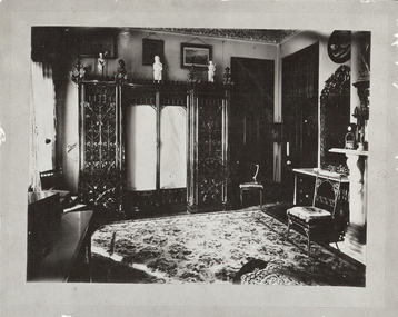
Photograph - FORTUNA COLLECTION: GEORGE LANSELL'S BEDROOM, FORTUNA VILLA, c1900
Black and white photograph of George Lansell's bedroom at Fortuna villa. History of object: George Lansell 'The Quartz King', Fortuna Villa, Chum Street, Bendigo. Ornate furnishings of a bedroom of period showing half of room. Ornate wardrobe and mirror on marble topped table next to marble fireplace. W Ninnisplace, residential -
 Bendigo Historical Society Inc.
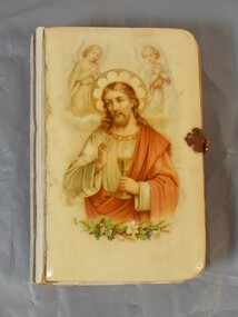
Book - German Bible
There was a large influx of German miners to the Bendigo gold fields and they mainly focussed on deep quartz mining. German enclaves existed at Diamond Hill, New Chum Gully, Victoria Hill, Ironbark and in the Whipstick area. The first Lutheran Church was built in 1865 and there were also two German schools. Small bible with hard cover, possibly bakelite/plastic. The cover has an image of Jesus with and angel above each of his shoulders and plants at the bottom of the image. Pages of bible have gold edging. There is a metal clasp to lock. The back is plain and a creamy color.german, bible, religion -
 Bendigo Historical Society Inc.
Document - THE RICH VICTORIA HILL AND ITS HISTORICAL ASSOCIATIONS, c1969
Document. 2 copies plus 4 loose sheets. 14 page typed document on the buildings and mines of Victoria Hill in the Gold Era. (10 pages document and 4 pages pictures). Document mentions 'Quartz Miners Arms' Hotel, Conrad Heinz - Bendigo Mayor 1894 and owned a butcher shop in Victoria Hill, British and American Hotel, Manchester Arms Hotel, Victoria Reef Gold Mining Company, Ironbark Mining Company, Hercules and Energetic Mining Company, William Rae, Gold Mines Hotel, David Chaplin Sterry, North Old Chum Mine, Ballerstedt's First Open-cut (J. C. T. Christopher Ballerstedt and Theodore Ballerstedt), Lansell's Big 180 Shaft (George Lansell), Victoria Quartz Mine, Mr E. J. Dunn (Chief Government Geologist). Pictures are- Victoria Hill from Rae's Open Cut, Looking North from Old Chum Hill to the Victoria Hill, Victoria Quartz on Victoria Hill, W. M. Rae's Crushing Works.cottage, miners, the rich victoria hill and its historical associations -
 Bendigo Historical Society Inc.
Document - DRAINAGE PROBLEMS - NEW CHUM MINES DRAINAGE PROBLEMS 1910
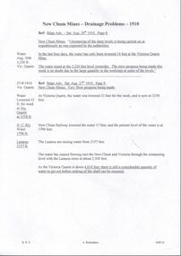
Handwritten extract from the Bendigo Advertiser 20/8/1910 Page 8. ''New Chum Mines. Unwatering of the deep levels is being carried on as expeditionsly as was expected by the authorities. In the last four days, the water has only been lowered 14 feet at the Victoria Quartz Mine. The water stood at the 3,226 feet level yesterday. The slow progress being made this week is no doubt due to the large quantity in the workings at some of the levels.'' From the Bendigo Advertiser 27/8/1910 Page 9. ''New Chum Mines. Very slow progress being made. At Victoria Quartz, the water was lowered 32 feet for the week, and is now at 3258 feet. New Chum Railway lowered the water 17 feet and the present level of the water is at 1796 feet. The Lazarus are raising water from 2157 feet. The water has ceased flowing into the New Chum and Victoria through the connecting level with the Lazarus Mine at about 2,500 feet. As the Victoria Quartz is down 4,614 feet, there is still a considerable quantity of water to get out before sinking of the shaft can be resumed.''document, gold, drainage problems, drainage problems, new chum mines drainage problems 1910, bendigo advertiser 20/8/1910 page 8 & 27/8/1910 page 9, new chum mines, victoria quartz, new chum railway, lazarus, new chum and victoria -
 Bendigo Historical Society Inc.
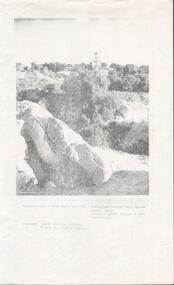
Photograph - VICTORIA HILL - VICTORIA HILL FROM RAE'S OPEN CUT
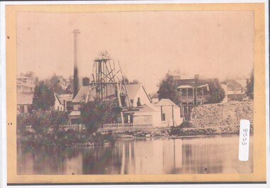
Photocopied photo of Victoria Hill from Rae's Open Cut. In the background are the Poppet legs of the Central Nell Gwynne Mine. On the left background is the Victoria Quartz Mullock. In the foreground are rocks and trees. Photo courtesy of Robert Wallace Studios, 6 Ruth St, Golden Square. Albert Richardson collection.photo, victoria hill, victoria hill from rae's open cut, central nell gwynne, victoria quartz, robert wallace studios -
 The Beechworth Burke Museum
Geological specimen - Actionlite and Pyrite
Actinolite is usually found in metamorphic rocks, such as contact aureoles surrounding cooled intrusive igneous rocks. It also occurs as a product of the metamorphism of magnesium-rich limestones. Pyrite is usually found with other sulfides or oxides in quartz veins, sedimentary rock, and metamorphic rock, as well coal beds, and as a replacement mineral in fossils. Actinolite is an amphibole silicate mineral. It is named after the Greek word "aktinos" meaning “ray” in allusion to the mineral's fibrous nature. Fibrous actinolite is a type of asbestos and was once mined along Jones Creek at Gundagai, New South Wales. Pyrite or "Fool's Gold" is the most common sulfide mineral. It is named after the Greek "pyr" meaning "fire" because it can be used to create sparks needed for a fire if struck against metal or a hard surface. Due to its gold colour, pyrite can be mistaken for gold and often forms alongside it, causing small amounts of gold to be present in rocks containing pyrite. Most importantly, pyrite is an ore of gold. Pyrite is sometimes used as a gemstone but is not great for jewellery as it easily tarnishes. In some fossils of ammonites – shelled cephalopods that died ~66 million years ago – pyrite also replaces the shell. This specimen is part of a larger collection of geological and mineral specimens collected from around Australia (and some parts of the world) and donated to the Burke Museum between 1868-1880. A large percentage of these specimens were collected in Victoria as part of the Geological Survey of Victoria that begun in 1852 (in response to the Gold Rush) to study and map the geology of Victoria. Collecting geological specimens was an important part of mapping and understanding the scientific makeup of the earth. Many of these specimens were sent to research and collecting organisations across Australia, including the Burke Museum, to educate and encourage further study. A small-medium-sized solid specimen with the minerals actinolite (dark green fibrous) and pyrite (brassy) with shades of brown, black/grey, and white. Actinolite is an amphibole mineral in the tremolite-actinolite series of calcium, magnesium, and iron silicates. Pyrite is an iron disulfide mineral.geological specimen, geology, geology collection, burke museum, beechworth, indigo shire, geological, mineralogy, pyrite, actinolite, victoria, sewyln, alfred selwyn -
 Federation University Historical Collection
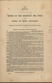
Booklet - Report, John Ferres, Government Printer, Report of The Secretary for Mines on the School of Mines, Ballarat, 1873, 1873
The following are listed as having pyrites treated at the Ballarat School of Mines: Louis Ballhausen, Alexander Millan, Tuckey Quartz Mining Co (New Zealand), Egerton Mining Company, Park Gold Mining Company, S. Livingston Learmonth, New North Clunes Mining Company, Malcolm Morris, Mr Seal.Five printed foolscap pages presented to both houses of Parliament in 1873. The report details budget, student numbers, examiners, candidate for examination, museum and rooms.ballarat school of mines, serjeant, r.m. serjeant, flude, joseph flude, richard gibbs, stawell, lynch, john lynch, r.s. mitchell, mitchell, bull, e. bull, bickett, j.m. bickett, parliament, louis ballhausen, alexander millan, tuckey quartz mining co (new zealand), egerton mining company, park gold mining company, s. livingston learmonth, new north clunes mining company, malcolm morris, seal, f. ive, rev. g.j. russell, p.c. fitzpatrick, j. m. bickett, b. bryant, n. kent, a. martin, p. matthews, j. robinson, j.m. troup -
 Stawell Historical Society Inc
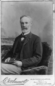
Photograph, Mr Edmund Craigie Grant
Edmund Craigie Grant died 1894 63 years. Married 1862. The firm Grant, Lamont & Coy were the first to erect Quartz Crushing machinery at Concongella Creek and later in Stawell at what became North Park. They built a house called "ALVIE" 39 Darlington Road (still standing 2005).Black & white photograph of Edmond Craigie Grant sitting in a chair holding a manuscript or magazine. Creelwaut Co (?) Burlington Galleries, corner of King & George Sts. Sydney Arcadestawell portrait -
 Bendigo Historical Society Inc.
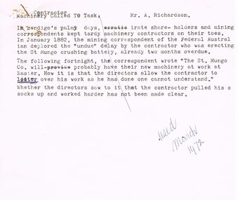
Document - ARTICLES FOR RHSV BENDIGO BRANCH NEWSLETTER MARCH 1972
Articles for RHSV Bendigo Branch Newsletter March 1972; 1. Article in ''Federal Australian'' (Jan 1882) re undue delays erecting the St Mungo crushing battery; 2. ''Moans and Groans'' re wages for miners and meeting at Royal Hotel of May 31st, 1873; reference to a Regulation of Mines law of Jan 1st 1874 (Angus McKay), margin note on handwritten copy states that ''Further information on (the) Act and the lot of the miners and engine drivers will be given in future issues of the Newsletter''; 3. Article with return and costs information about working on a claim - details of shaft and sinking - (Grant and??Co), adjacent to private Victoria Reef Quartz Co., later the Victoria Quartz.document, gold, mining in bendigo -
 Bendigo Historical Society Inc.
Document - Return of Gold Mines 1859, 1876
Four page photocopy document 'Legislative Assembly 1859, Return of gold mine leases'. Information detailed includes: lessee; name of company; gold field; mining district; description of lease (alluvial/quartz) area; term; annual rent; capital, machinery value; minimum number of men to be employed. Example: Union Co., Sheepshead Gully, quartz mine, area 3 roods, and 22 perches, term 10 years, amount of rent 4 pounds 8 shillings and ninepence, capital 4,000 pounds, machinery 3,000 pounds, minimum amount of men to be employed - 2. Names of mine lessees: W. Tongue, R. Lysle, G. Nevison, T. Porter, J. Griston. mining, sandhurst, mining leases, labour convenant, union co., sheepshead gully, quartz mine, legislative assembly, return of gold mines, -
 Bendigo Historical Society Inc.
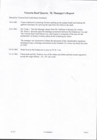
Document - VICTORIA QUARTZ - VICTORIA REEF QUARTZ MINE MANAGER'S REPORT
Two copies of the Victoria Reef Quartz Mine Managers report. The report mentions putting up the poppet heads, drainage assessment, water level and two men offered 50/- per week. Dates 14/6/1861, 22/6/1861, 18/10/1861 and 13/12/1861.document, gold, victoria quartz, victoria quartz, victoria reef quartz mine manager's report, victoria reef gold mines, gerraws, mr cook, mr sterry, mr mollison, endeavour coy, the victoria reef gold mines coy, ironbark co, endeavour, chenoweth, mr hoskins -
 Bendigo Historical Society Inc.
Photograph - View of Hustler's mine
Named after Thomas Hustler who purchased the lease in 1854. It was an opencut mine at this stage and Hustler patented a quartz crushing machine. HE later sold the mine to the Hustlers Reef Mining and drainage Co. and by 1865 the Great Extended Hustler's was operating 31 levels at a depth of 1053meters. The mine ceased operation in 1921.A4 copy of an original photograph, sepia toned print. View of hustler's Mine facing Barnard Street, Bendigohustler's, barnard street, james brierley -
 Bendigo Historical Society Inc.
Photograph - FORTUNA COLLECTION: FORTUNA VILLA
Originally built by Christopher Ballestedt (1796-1869) and his son Theodore. The Ballestedt's pioneered open cut and quartz mining on the Bendigo gold field. They were very successful. After Christopher's death, Theodore continued until 1871 when he sold Fortuna, their mines and equipment to George Lansell for 30,000 pounds.Two Large black and white photographs of Fortuna Villa in the early days. Also 2 portrait photos of Edith and George Lansell. bendigo, house, fortuna villa -
 Bendigo Historical Society Inc.
Plan - FORTUNA COLLECTION: FORTUNA VILLA
Originally built by Christopher Ballestedt (1796-1869) and his son Theodore. The Ballestedt's pioneered open cut and quartz mining on the Bendigo gold field. They were very successful. After Christopher's death, Theodore continued until 1871 when he sold Fortuna, their mines and equipment to George Lansell for 30,000 pounds.Four large plans of Fortuna villa. Scale 1:50 Australian survey office - Victoria Department of Administrative services. Fortuna Bendigo - Army Survey Regiment. Dept. of Defence - Army. Terrestrial Photogrammetric Survey. Project number: 8001/2. Reg. File: 64/531. Survey File:631. Draftsman: M.A. Osciak. Surveyed by G. Tucker. Date of Survey: 14/05/79. There are 4 large such plans in a plastic bag the measurement of the plans is approx. 115cm X 80 cm.plan, bendigo, fortuna villa -
 Bendigo Historical Society Inc.
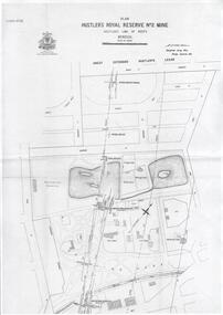
Plan - Hustler's Royal Reserve No. 2 Mine, April, 2014
One page plan (photocopy) of Hustler's Royal Reserve No. 2 Mine (Park Shaft) showing mine location, dams, tennis courts, bowling green, Jail (sic) Barnard Street, View Street and Park Road. Whitelaw plan, 1913.goldmining, accident, quartz, mining, hustler's royal reserve no. 2 mine, park shaft, hustler's line of reef, gaol, -
Bendigo Historical Society Inc.
Document - MINER'S RIGHT - SHOW YOUR LICENCE
Handwritten notes Titled 'Show Your License'. License introduced in 1851 at 30 shillings a month. All had to pay gold license. In 1855, the fee was abolished and was replaced by the Miner's Right. Also some newspaper reports: Duke of Edinburgh's visit, Engineers & Drivers Meeting, accidents, inrush of water at the Victoria Quartz.document, gold, miner's right, miner's right, show your license, royal hotel, young chum, comet, robin hood, extended hustlers, lazarus, sth belle vue, true blue, unity, garden gully united, victoria queen, david clapperton, thomas clapperton, new chum consolidated, gt ext'd hustlers, victoria quartz, new chum railway, new chum united, lansell's 222, lazarus, old chum, new chum & victoria, devonshire mines, belmont & saxby -
 Bendigo Historical Society Inc.
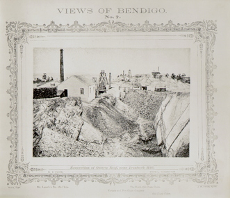
Photograph - VIEWS OF BENDIGO - QUARTZ REEF
Black and white 'Views of Bendigo' No. 7. Excavation of Quartz Reef, near Ironbark Hill. Panorama of Mullock heaps and four mine sites. Copy of frames photo?. Inscriptions: Mine sites named - 'Lansell's 180 claim', 'Victoria and New Chum Company', 'North Old Chum Claim', 'Old Chum Mine'.NJ Caire, Sandhursttopic, mining -
 Bendigo Historical Society Inc.
Memorabilia - GOLD NUGGET COLLECTION: THE POSEIDON
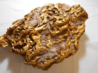
A replica of the gold nugget 'Poseidon' that was discovered on the 18th of December 1906 at Tarnagulla. It was found 10 inches below the surface, 2 inches above bedrock with much quartz. It was found by Woodall and Party and named after a famous racehorse of the time. Gross weight 953 ozs. Net 703 ozs. (See additional research).mining, models, plaster model of victorian gold nugget, https://www.australiangeographic.com.au/topics/history-culture/2016/11/australias-biggest-gold-nuggets/ -
 Clunes Museum
Photograph, 30.7.2001
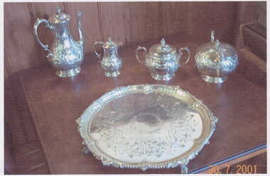
A COLOUR COPY OF A PHOTOGRAPH OF A SILVER TEA SERVICE PRESENTED TO JOHN LEWIS ESQ. BY A FEW OF THE SHAREHOLDERS OF THE NEW NORTH CLUNES QUARTZ MINING CO. IN RECOGNITION OF HIS SKILFUL, ECONOMICAL AND HONORABLE MANAGEMENT OF THE COMPANY'S MINE FOR NINE YEARS, DURING WHICH PERIOD THE SHAREHOLDERS RECEIVED IN DIVIDENDS Pounds 460.000 BALLARAT 1876.Image auto date; 30.7.2001local history, photography, photographs, mining -
 Bendigo Historical Society Inc.
Document - ALBERT RICHARDSON COLLECTION: VICTORIA HILL
Sixteen-page document with details about Victoria Hill, Victoria Spurs, East Victoria Reef, Try Me Well Reef and Hercules Reef. (ref: Dicker's Mining Record 23rd November 1861) Wittschiebe & Co's Claim Victoria Hill, Victoria Reef Gold Mining Company and Victoria Quartz are mentioned.bendigo, mining, victoria hill -
 Bendigo Historical Society Inc.
Document - MINING REPORTS - LIST OF GOLD MINES OR MINING COMPANIES
Handwritten list, (typed copy) by Albert Richardson, of Gold Mines or Mining Companies. Listed are: Australian United Quartz Co Sandhurst, Advance Co, Big Hill Tribute Co, Birds Reef Railway Reserve Mine Co, British Banner Gold M Co, Brookfield Gold M Co, Carlisle North Garden Gully, Caroline Gold M Co, Central Garden Gully, Charles Gavin Duff Gold M Co, Charleston Quartz, Cinderella Co, Collman Tacchi & Nelson, Confidnece Gold M Co, Cornish United Gold M Co, Derby Gold Mine Co, Dixon's Tribute Co, Ellesmere black Lead Tribute Co 1871, Empire Amalgamated, Extended Gold M Co (Majorca), Extended Co Victoria Reef, First Chance Tribute, Fortuna, Golden Fleece & Heales United, Garden Gully United, Garden Gully, Golden Fleece, Golden Point, Golden Lion Tribute Garden Gully Reef, Great Golden Fleece Co, Great Wonder Co, Gilmons Golden Palm Trib Co, Golden Garden Gully Co 1873, Golden Sovereign Extended Trib Co 1872, Great Extended Garden Gully Co 1874, Great Extended South Hustlers Co 1872, Great Republic Corp, Ironbark Co, Kangaroo Flat Steam Puddling & Qaurtz M Co, Riverpool Gold M Co, Iron Duke Co 1871, Henry Van Der Hugen Pioneer G M Co, Kent M Co, Kentish Co, Mariners Reef Co, Mary Hill Trib Co, Morning Star Gold Mine Co, Mount Korong Lane's Reef M Co, New Chum & Victoria Trib Co, New Hopeful Gold M C, New Homeward Bound, New Lord Warden Trib Co, North Lord Warden Trib Co, North Nelson, North Golden Pyke Co, North Old Chum, North Shamrock, North Birds Reef Co, North Birds Tribute Co, New Chum Freehold, New Era, No 3 Wilson's G M C, Odin Reef Co, Oriental Perserverance G M C, Paddy's Reef Trib Co, Palm Gold M Co, Palm Tribute Co, Pearl Tribute Co, Pegleg Gully Quartz G M C, Pegleg Quartz M C, Princess Dagmar G M C, Prince of Wales Amalgamated (Tarnagulla), Pyrances Gold M C, Passby United G M C, Quartz Hill Quartz M C, Pevieres Victory Trib Co, Royal Oak Quartz, Royal Standard Trib Co, Royal George Quartz G M C, Royal Golden Fleece, Sable Chief G M C, Sainia Reef Quartz M Co, South Fraser Reef G M C, Southern New Chum Gold M C, Shanandoor Tribute, Sebastian Gold M Co, Sophia & Redan G M Co, Youth Bell Vue Co, Shannon Company, South Extended Wallaby Co, South Ramrod Co, South Royal Hustlers Co, South Wallaby Trib Co, United Hustlers, United Hustlers & Redan Co, United Bros Tribute Co (Myrtle Creek), United Gold Mine Co, Victoria Reef Gold M Co, Victorian Consolidated M Co, Victoria Reef Quartz, Virginia Gold M Co, Victory and Pandora, Young Chum, South Homeward Bound Co, South Shilling Co, South Nuggetty Co, South Devonshire Co,South Keep it Dark, Try Again Tribute Co Victoria Hill.document, gold, mining reports, mining reports, list of gold mines or mining companies, australian united quartz co sandhurst, advance co, big hill tribute co, birds reef railway reserve mine co, british banner gold m co, brookfield gold m co, carlisle north garden gully, caroline gold m co, central garden gully, charles gavin duff gold m co, charleston quartz, cinderella co, collman tacchi & nelson, confidnece gold m co, cornish united gold m co, derby gold mine co, dixon's tribute co, ellesmere black lead tribute co1871, empire amated, extended gold m co (majorca), extended co victoria reef, first chance tribute, fortuna, golden fleece & heales united, garden gully united, garden gully, golden fleece, golden point, golden lion tribute garden gully reef, great golden fleece co, great wonder co, gilmons golden palm trib co, golden garden gully co 1873, golden sovereign extended trib co 1872, great extended garden gully co 1874, great extended garden gully co 1874, great extended south hustlers co 1872, great republic corp, ironbark co, kangaroo flat steam puddling & qaurtz m co, riverpool gold m co, iron duke co 1871, henry van der hugen pioneer g m co, kent m co, kentish co, mariners reef co, mary hill trib co, morning star gold mine co, mount korong lane's reef m co, new chum & victoria trib co, new hopeful gold m c, new homeward bound, new lord warden trib co, north lord warden trib co, north nelson, north golden pyke co, north old chum, north shamrock, north birds reef co, north birds tribute co, new chum freehold, new era, no 3 wilson's g m c, odin reef co, oriental perserverance g m c, paddy's reef trib co, palm gold m co, palm tribute co, pearl tribute co, pegleg gully quartz g m c, pegleg quartz m c, princess dagmar g m c, prince of wales amalgamated (tarnagulla), pyrances gold m c, passby united g m c, quartz hill quartz m c, pevieres victory trib co, royal oak quartz, royal standard trib co, royal george quartz g m c, royal golden fleece, sable chief g m c, sainia reef quartz m co, south fraser reef g m c, southern new chum gold m c, shanandoor tribute, sebastian gold m co, sophia & redan g m co, youth bell vue co, shannon company, south extended wallaby co, south ramrod co, south royal hustlers co, south wallaby trib co, united hustlers, united hustlers & redan co, united bros tribute co (myrtle creek), united gold mine co, victoria reef gold m co, victorian consolidated m co, victoria reef quartz, virginia gold m co, victory and pandora, young chum, south homeward bound co, south shilling co, south nuggetty co, south devonshire co, south keep it dark, try again tribute co victoria hill. -
 Bendigo Historical Society Inc.
Document - ALBERT RICHARDSON COLLECTION: EARLY HISTORY OF THE BENDIGO GOLDFIELD
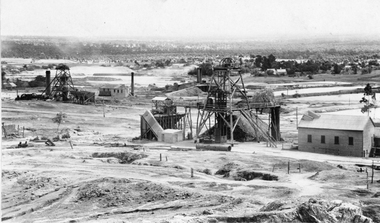
Typed foolscap two sided document with information about the early history of the Bendigo Goldfield. Topics include the first gold discovery, how gullies were worked, quartz reefing, gold cakes, hand dollies and Chilian mills. Some brief statistics of the Bendigo goldfield include the total gold yield of 17,370,561 ounces plus 5,000,000 oz sold outside Bendigo. The greatest depth reached by any mine in the State, 4,593 feet below surface, or 3,700 feet below sea-level, was attained by the Victoria Quartz Company. About 100 shafts exceed a depth of 1,000 feet, of which 40 are between 2,000 and 3,000 feet deep, fifteen are between 3,000 and 4,000 feet and two are over 4,000 feet.bendigo, mining, mines department -
 Bendigo Historical Society Inc.
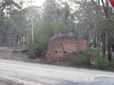
Document - LONG GULLY HISTORY GROUP COLLECTION: TALES OF VICTORIA HILL
Two printed pages titled Tales of Victoria Hill. Mentioned is the gold yield on the New Chum Line of Reef, early gold discovery, Christopher Ballerstedt and his son Theodore, Theodore building Fortuna as well as a crusher or battery in its grounds. He believed he had exhausted the riches from his claims and sold the claim on the hill to George Lansell, deepest gold mine, interconnecting to neighbouring mines to obtain the required up and down drafts for ventilation, rising of the water levels resulting the closure of the Victorian Quartz Mine when a rope broke and the equipment that is still there. An accompanying photo of the Victoria Quartz Mine shows the buildings, chimney and poppet legs and a man standing in front of a building. There is also an accompanying floppy disc.bendigo, history, long gully history group, the long gully history group - tales of victoria hill, j n macarthy, christopher ballerstedt, theodore ballerstedt, fortuna, george lansell, lansell's 180, victoria quartz co, victorian consols, bendigo's deepest known gold bearing reef -
 Ballarat Heritage Services
Photograph - Photograph - Colour, Clare Gervasoni, Tarilta, 2017, 16/07/2017
Tarilta is a rural locality and former gold-mining town 12 km south of Castlemaine, 4 km north-west of Guildford and 3 km north-east of Vaughan. The last gold mining activity took place around the 1880s. It was originally Kangaroo Flat, being located where the Kangaroo Creek enters the Loddon River. It was surveyed and named in 1864. Gold was discovered at Tarilta in 1853. The Tarilta School was opened in 1860 in a Wesleyan chapel, and closed i n1925. In 1864 a township was surveyed and named Tarilta, the word being derived from an Aboriginal expression thought to mean kangaroo. In 1865 Bailliere’s Victorian gazetteer described Tarilta as being an alluvial and quartz gold-mining town with three quartz-crushing mills, three horse-puddling machines and two hotels. The elevated nature of the land around Tarilta made it accessible only by horse and dray, or on horseback. Colour photograph of Tarilta in Central Victoria. tarilta, central victoria, landcape -
 Ballarat Heritage Services
Photograph - Photograph - Colour, Steele's Pioneer Mine Ruins, Yandoit, 2016, 18/01/2016
Steele's Reef was opened in 1859 along with a number of other reefs in the Yandoit area. The reef was worked by small mining parties until the late 1880s. In 1887, the Steele's Reef Quartz Mining Company fixed steam pumping machinery and commenced sinking a shaft. The company were unable to find a profitable ore body and after two years work closed down. By this time their shaft had reached a depth of 150 feet. The mine was then taken over by the Pioneer Quartz Mining Company who appear not to have worked the mine. In 1906, the Steele's Pioneer Company commenced work, erecting a winding winch at the old shaft sunk by the Steele's Company. The next year the company erected a 10-head battery, set of poppet legs, a pumping engine. Sinking the shaft a further 100 feet, the company struggled to find payable ore and soon closed down.Colour photographs of the remnants of Steele's mine at Yandoit, Victoria. steele's mine, yandoit, mining, ruins -
 Kew Historical Society Inc
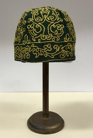
Headwear - Green Cotton & Yellow Silk Ribbon Smoker's or Lounge Cap, 1860s
The context in which the hat was made and worn assists in establishing its potential historic significance. 'Bailliere's Victorian Gazetteer and Road Guide containing the most recent and accurate information as to every place in the Colony' (1870), describes the village of Vaughan as being located on the road from Daylesford to Castlemaine. In 1870 the Vaughan was deemed to be entirely a gold mining area, gold having been discovered in the district in 1853. Intriguingly the entry in the Gazetteer claims that the electoral division of Vaughan began at the junction of the Middleton Creek and the Loddon River, so perhaps the cap might have belonged to a member of a significant local family. In 1870, Vaughan had a population of about 1000 persons and included almost 300 dwellings. Articles from newspapers, published on Trove refer frequently to a Mr Middleton as a litigant in court cases before the Vaughan Court in the 1860s. By the 1870s, the Mt Alexander Mail, in an article on ‘Mining: The Pioneer Wheel’ describes the success of Mr Middleton and his Middleton’s Reef Gold Quartz Mining Company, which had built the largest water wheel in the Colony. The wheel was 20’ in diameter and 2’ wide. Quartz mining as practiced by companies such as Middleton’s had become necessary after the exhaustion of alluvial quartz mining deposits in the 1860s. So we can probably establish a link between the cap and a significant mining identity in the period in which the article was made. The historical significance of the cap is only one part of the story. Caps such as the Middleton example can also be items of aesthetic significance as they were typically, examples of women’s work, using published patterns in magazines such as the Ladies Home Magazine. While women might follow or adapt a published pattern, their choice of materials reflected what was available locally. The fine hand stitching on this example is evidence of high quality domestic needlework. The maker crafted the cap from five triangular pieces of cotton cloth, each piece lined with a faded yellow net. The net provides some stiffening for the cap and has a functional purpose in that it anchors the hand-stitched, looped design of yellow silk ribbon that decorates the surface of the cap. Gentleman’s smoking (lounging) cap believed to have been made in c.1860-69. The conical hat is made of a dark green cotton fabric embroidered with narrow ribbon of a paler green silk. The unlined rimless hat is made of four pieces of fabric. There is no evidence of the hat at one stage featuring a tassle. The original donation record noted that the cap had been made for, and was worn by, a Mr Middleton, of Vaughan in Central Victoria. Nilhats, smokers hats, men's clothing -
 Bendigo Historical Society Inc.
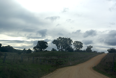
Photograph - Victoria Hill, Bendigo, 1973
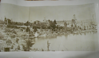
Gold was discovered on Victoria Hill in 1854 and by 1861, 1,200,000 ounces of gold had been extracted from the site. The first claim was bought for 80 pounds by Prussian immigrant Christopher Ballerstedt and his son Theodore. Christopher Ballerstedt was nicknamed the "Father of the Hill" and was the first to prove that gold reefs extended below the surface. His 200-foot plus mine shafts yielded quartz rich with gold, inspired other miners, and were instrumental in Bendigo becoming the world's deepest and richest goldfield. The site still features relics of nineteenth century mining including quartz crushing machinery and the foundations of George Lansell’s 180 mine. These features are characteristic of Bendigo’s mining history and represent two prominent nineteenth century miners, Christopher Ballerstedt and George Lansell, who held important roles in the development of Bendigo. Victoria Hill Quartz Gold Mines are registered as a site of significance. The site is of historical, archaeological and scientific importance to Victoria. The mines represent the symbolic heart of Bendigo’s gold mining history and the importance that mining played in wealth creation and the development of Victoria. The diggings reserve is accessed from the rear of Albert Richardson Reserve located at 40-56 Marong Road, Ironbark. The site has steep and unformed paths and is closed to the public at dusk. It is important to stay to the paths to avoid the diggings. Interpretive signs help visitors to appreciate the importance of the site and the remaining relics of Bendigo’s mining history.Victoria Hill Ironbark, Bendigo. Photos of the poppet head, sand heap, tailings, shafts and tunnels. Before development into a tourist attraction.history, bendigo, victoria hill, ironbark, diggings -
Clunes Museum
Map, DEPARTMENT OF MINES, Untitled, c1859
All maps show names and locations of mines operating in the district (see reference section link to article).1 Map of Creswick Clunes - lists 45 mines in the Clunes enlargement and 100 mines in the Creswick enlargement .2 Department of Mines map of Clunes Creswick and shows the McDonald & Co. Pre-emptive area. Indexes for quartz and alluvial mine locations .3 Topographical map Ref GF23 Clunes Mt. Greenock Talbot.1 360 Scale 1:2500 .2 303/59 33 hand written in ink "received 15 October 1859" signed by R Broughton, James Stevenson - District Mining Surveyor .3 40 chains to an Inchgold mining, dept of mines -
 Stawell Historical Society Inc
Photograph, Sloane's & Scotchman United Mining Co in Stawell looking North West with Poppet Heads & Sheds 1914 -- Photo & Colured Painting
Poppet Heads, Ore bin Winding Engine Shed Sloane's & Scotchmans United Quartz Mining Co looking North West Moonlight dams in background. Mine on left is the old Extended mine where the winding engine shed has been destroyed by fire. Just behind that is the Winding Engine Shed of the Oriental Mine without the poppet head.View of two mine sites with poppet heads and engine sheds. Settling dams in background.mining, panorama -
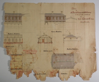 Bendigo Historical Society Inc.
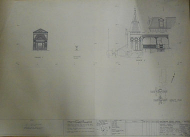
Plan - MARKS COLLECTION: PLAN OF ALTERATIONS AND ADDITIONS TO THE PRIVATE RESIDENCE OF GEO. LANSELL ESQR
Fortuna Villa was owned from 1855 to 1871 by Christopher and Theodore Ballerstedt, Australia’s first mining magnates. In 1871 it was purchased by George Lansell (The Quartz King) being one of Australia’s most successful and adventurous nineteenth century gold mine owners and speculators. Lansell made numerous alterations and extensions to the building. It remained in the Lansell family until 1935Plan for the alteration and additions to Fortuna Villaa, the private residence of George Lansell Plan shows southern, eastern & western elevations, floor and roof plan for the additions to the residence Coloured hand drawn construction plan Plan is undated plan has severe damage on LHS and bottom of the sheetfortuna villa, george lansell, building plans, c & t ballerstedt