Showing 6755 items
matching rivers
-
 Orbost & District Historical Society
seed bag, mid 20th century
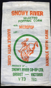
The bag is unused. These bags would have been used by the Snowy River Co-Op in Orbost in the late 1960's-1980's. It would have been used for packing popping corn for sale. Snowy River Seeds started life as a farmers' co-operative (Snowy River Co-op) in 1967.This item is significant because it was specially made for the seed bean industry which has been a major industry in the Orbost district for over a century.A white woven synthetic fibre bag used to store popping corn prior to selling.On front of bag - Inside green circle is "Man From Snowy River" in orange and green writing. 25kg net Variety is Micropop Produce of..... Snowy River Co-Op Ltd Orbost - Victoriacorn seed-bag snowy-river-co-op -
 Marysville & District Historical Society
Photograph (Item) - Black and white photograph, Unknown
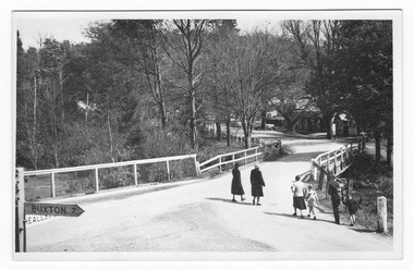
A black and white photograph of a bridge over the Steavenson River in Marysville in Victoria.A black and white photograph of a bridge over the Steavenson River in Marysville in Victoria. The Steavenson River is named after the Victorian Assistant Commissioner of Roads and Bridges, John Steavenson who arrived in Victoria in the early 1860s.marysville, victoria, steavenson river, photograph, john steavenson -
 Marysville & District Historical Society
Photograph (Item) - Black and white photograph, 1953
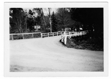
A black and white photograph of a bridge over the Steavenson River in Marysville in Victoria.A black and white photograph of a bridge over the Steavenson River in Marysville in Victoria. The Steavenson River is named after the Victorian Assistant Commissioner of Roads and Bridges, John Steavenson who arrived in Victoria in the early 1860s.THE BRIDGE/ MARYSVILLE '53 7340marysville, victoria, steavenson river, photograph, john steavenson -
 Marysville & District Historical Society
Photograph (Item) - Black and white photograph, 1954
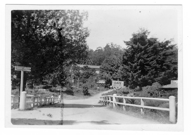
A black and white photograph of a bridge over the Steavenson River in Marysville in Victoria.A black and white photograph of a bridge over the Steavenson River in Marysville in Victoria. The Steavenson River is named after the Victorian Assistant Commissioner of Roads and Bridges, John Steavenson who arrived in Victoria in the early 1860s.Marysville 1954marysville, victoria, steavenson river, photograph, john steavenson -
 Marysville & District Historical Society
Photograph (Item) - Black and white photograph, Fred Kruger, Scene on the Watts River near Fernshaw, Unknown
A copy of a black and white photograph on the Watts River near Fernshaw in Victoria.A copy of a black and white photograph on the Watts River near Fernshaw in Victoria taken by Fred Kruger. Fred Kruger (born Johan Friedrich Carl Kruger, 18 April 1831 – 15 February 1888) was a German-born photographer noted for his early photography of landscape and indigenous peoples in Victoria, Australia. Fernshaw was a rural township 63 km northeast of Melbourne and 10 km northeast of Healesville. Situated on the Watts River, near where a log had fallen making a convenient crossing, Fernshaw was settled in the 1860s. It provided good country for orchards and berry growing. The location was at the foot of Blacks Spur, with Mounts Juliet and Mondah rising on either side, providing spectacular scenery. There were nearby fern gullies giving rise to the name – ‘shaw’ is old English for thicket or wood. By 1875 Fernshaw had a post office (1865), two hotels, a school (1871), and stores. It was famed for its beauty, attracting tourists. In 1886 the Melbourne and Metropolitan Board of Works began work on the Watts River water catchment scheme – later to become Maroondah – and the Board obtained approval for the catchment country to be reserved and kept free of settlement. This required the removal of the Fernshaw township, which was completed by about 1890.fernshaw, watts river, victoria, fred kruger, photograph -
 Tatura Irrigation & Wartime Camps Museum
Book, Investigating the Mighty Murray, 1993
The River Murray - history at a glance. Murray Darling Basin Map 1902Front and back covers of Murray river scenes. Teachers' Guide Bookletsirrigation, books, school, educational -
 Orbost & District Historical Society
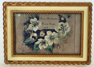
illustration, Cameron, Ina, 1910
Ina Cameron was the daughter of Alex Cameron and Helen nee Stirling. They lived for a time at Metung and then at Cann River. She was the grand-daughter of the Hon. James Cameron. She married Jack Campbell.Small ink illustration of flowers (blossoms) with foliage on pink background. There is a box showing name and date. The picture is in a plastic gold and cream frame with scalloped edges and has a stand on the back.Front - Ina Cameron, Cann River, 1910illustration cameron, ina cann-river -
 Ballarat Heritage Services
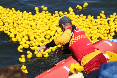
Digital photographs, L.J. Gervasoni, Moyneyana Ducks, c2013
Each new year's day there is a duck race at Port Fairy on the Moyne River. Colour photograph of rubber ducks in the Moyne River on new year's day. landscape, river, moyneyana, duck race, fundraiser, slsc, surf life saving club, port fairy, rubber ducks, moyne river -
 Orbost & District Historical Society
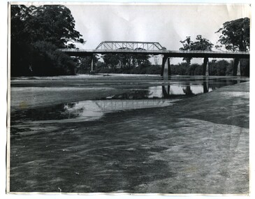
black and white photographs, 1937
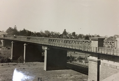
These photographs are of the bridge across the Snowy River at Orbost which was replaced in 1976. This bridge over the Snowy River was opened on July 4 1922. It was constructed in 1922 alongside the previous suspension bridge. Its building was a combined effort of the Victorian Railways and the Country Roads Board at a cost of 35,000 pounds. It was replaced in 1976 by the present bridge after several major floods.This bridge was replaced in 1976 after several major floods. This is a pictorial record of that bridge.Three black / white photographs of a truss bridge across a river.bridge-snowy-river orbost-bridge-1937 -
 Warrnambool and District Historical Society Inc.
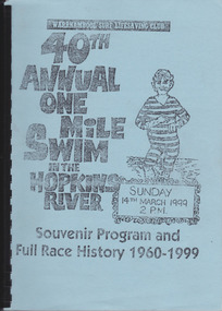
Work on paper - Report, Warrnambool Surf Lifesaving Club, 40th Annual One Mile Swim of the Hopkins River, 1999
The Hopkins River One Mile Swim started in 1960 as part of an Aquatic Day to raise funds for the Warrnambool Olympic Pool. Since 1961 a measured One Mile Course (1600 metres) was used, the course being up river for approx. 286 metres, then to the bridge and back to the jetty to the finishing line. It was a handicap race. The race was abandoned after 46 years (2005). The booklet is of some importance as it gives the details of the Hopkins River One Mile Race, an event that was a prominent one in Warrnambool for 46 years. The booklet records the achievements of the competitors and the work of the committees involved and will be useful for researchers. This is a booklet containing a souvenir program for the 40th Annual One Mile Swim in the Hopkins River in 1999 and a Full Race History from 1960 to 1999. It has been produced in-house by the Warrnambool Surf Lifesaving Club and has a blue cardboard front cover and a grey back cover. The photocopied and typed pages have been bound with black plastic. The contents include newspaper cuttings, photocopies of photographs, lists of winners and a list of the race’s sponsors. There are three loose sheets.Front Cover: Warrnambool Surf Lifesaving Club, 40th Annual One Mile Swim in the Hopkins River, Sunday 14th March 1999, 2 p.m., Souvenir Program and Full Race History 1960-1999warrnambool surf lifesaving club, hopkins river mile swim, hopkins river -
 Stawell Historical Society Inc
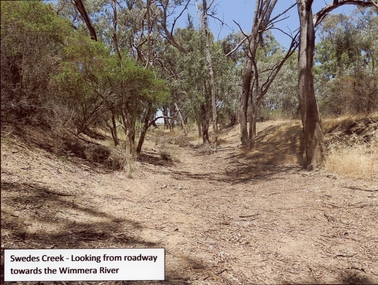
Photograph, Swedes Creek Looking looking towards the Wimmera River 2017 -- Coloured
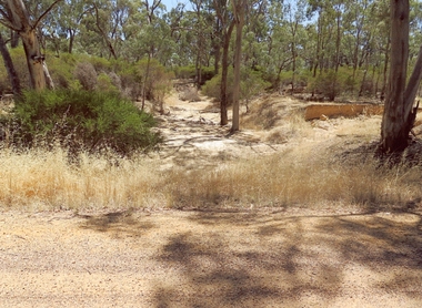
Colour Photo of Swedes Creek looking from roadway towards the Wimmera River 2017. (Jan)Colour photograph of a dry creek bed. Trees along and around the dry creek.Swedes Creek - Looking from roadway towards the Wimmera River.water -
Port Fairy Historical Society Museum and Archives
Photograph
Aerial view across the Moyne river Black and white photograph of Martins Point, river moyne and the pudney grounds from the air aerial, moyne, river, martin's point, port fairy, barge, dredge, pudney ground, griffith island -
 Bendigo Historical Society Inc.
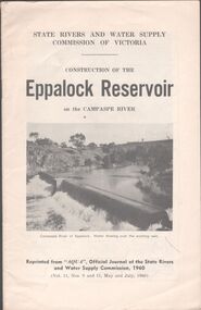
Booklet - Aileen and John Ellison collection: Eppalock Reservoir
Eppalock Reservoir was built between 1960 and 1964 and is the only reservoir on the Campaspe River. The main embankment is 700 meters long and 47 meters high. It has a total capacity of 304,651 ML.Booklet by the State Rivers and Water Supply Commission of Victoria - Construction of the Eppalock Reservoir on the Campaspe River. Reprinted from "Aqua", official journal of the State rivers and water supply commission, 1960 (Vol.11, Nos. 9 and 11, May and July, 1960)lake eppalock, reservoir -
 Orbost & District Historical Society
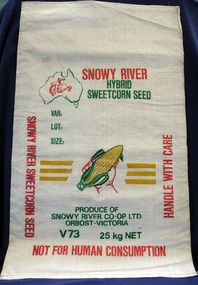
seed bag
This unused bag would have been used by Snowy River Co-Op Ltd to pack sweet corn in the late 1960's -1980's Snowy River Seeds started life as a farmers' co-operative (Snowy River Co-op) in 1967 specialising in horticulture. Snowy River Co-op were the original creators of Snowy Seeds.This item is significant because it was specially made for the seed bean industry which is a major industry in the Orbost district.A white synthetic woven fibre bag used to pack sweet corn prior to sale. It has red, green, yellow print.On front of bag - Logo of Man From Snowy River in outline map of Australia with a hand holding corn cob in the centre, Produce of Snowy River Co-Op Ltd Orbost- Victoria V73 25kg NETsweet-corn seed-bags snowy-river-co-op -
 Orbost & District Historical Society
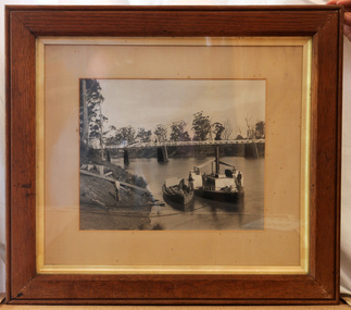
framed black and white photograph, C1900
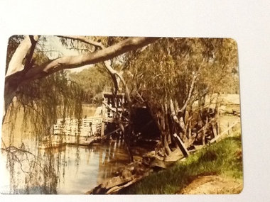
The P.S. Curlip was built by Samuel Richardson & Sons at a Tabbara sawmill in 1889. Alan Richardson, shown in the photograph, was the captain. It was operated along the Snowy River in Australia's Gippsland region between 1890 and 1919, before being washed out to sea, and broken on Marlo beach, by a flash flood in 1919. James Winchester was born in Geelong in 1856. He first sailed into Marlo, aged 15 and returned in the 1870's. he worked on the snagging punt on the Snowy River and also on the Paddle Steamer Curlip which towed the barges to collect the maize grown along the Snowy River. Wooden chutes were constructed along the river banks to load bagged maize onto the barges. The bags of maize were sent down the chutes into the waiting barges. This is a pictorial record of the iconic Paddle Steamer Curlip which has a significant association with Orbost. It records the method of loading maize onto barges through a wooden cchute.A large framed black / white photograph of the Paddle Steamer Curlip and a barge on a river. The barge is being loaded with maize through a large chute. In the background is the Snowy River bridge. the frame is wood. There is also a copy.on back of copy - " Jim Winchester, Alan & Frank Richardson, Curlip - barge & chute for loading maize"p.s.-curlip transport-shipping richardson winchester-james snowy-river maize-loading -
 Port of Echuca
Colour photograph, Approx.1979
This photograph shows a punt (with a dingy tied to it ) moored to the wharf structure on the Murray river at Echuca. Punts were used to transport people and goods from one side of the river to the other.Punts were used to cross the Murray river at many spots before bridges were built. Henry Hopwood set up his initial business with punts across the Murray and Campaspe rivers, charging people, animals and vehicles to cross the rivers.Colour photograph of a punt tied to the port structure, seen through the foliage of gums on the river bank.On reverse:" This paper manufactured by Kodak"port of echuca, hopwood's punt, echuca, port of -
 Port Fairy Historical Society Museum and Archives
Photograph, 1906
Iron Steamship Casino in the Moyne River 1906B&W photograph of the SS Casino moored in the Moyne River opposite the lifeboat shedship, boat, sea, river, casino -
 Stawell Historical Society Inc
Photograph, Dunmunkle Creek looking towards Wimmera River 2017 -- Coloured
Colour Photo of Dunmunkle Creek looking towards Wimmera River 2017.Colour photograph of dry creek bed surrounded by vegetation. Dunmunkle Cree looking towards Wimmera River from roadway - 2017.water -
 Kew Historical Society Inc
Photograph, Outer Circle Railway Viaduct, 1919
Railway Viaduct constructed for the Outer Circle Railway. Bridge designed by John Monash, engineer. Converted into a state highway, 1930s.Dateable photo of an important piece of Victorian railway infrastructure.Photograph of Outer Circle Railway Bridge over River Yarra, Fairfield. Looking toward Lugton Street, showing fence underneath taken from the Chandler Highway. Reverse: "Outer Circle Railway Bridge over River Yarra Fairfield, H0276, Property of Miss Foley"railway viaduct, chandler highway -
 Queenscliffe Maritime Museum
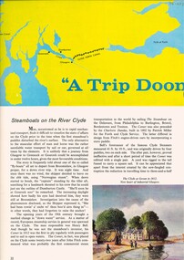
Pamphlet - Clyde River Scotland, Pamphlets, brochures and news article re travelling on the Clyde River Scotland
Clyde River boats ScotlandClyde River boatsColourt & B&W brochures, pamphlets & news article re boats on the Clyde River Scotland.Reverse " NIL "historical references -
 Orbost & District Historical Society
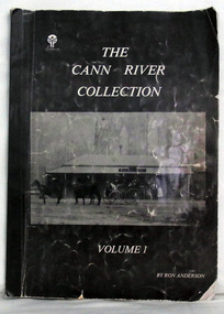
book, Snowy River Mail as "Mail" Print, The Cann River Collection, March 1985
This book was produced by Ron Anderson, a resident of Cann River in 1985 - 159 years following the establishment of Victoria. It contains a collection of photographs as well as a brief history of the Cann River District. This book is a pictorial record of Cann River and as such is a useful research tool.A large format black covered book, titled, "The Cann River Collection Volume 1". On the front cover is a black and white photograph of a four-wheeled buggy pulled by four horses standing outside a hotel. It contains a collection of photographs of the Cann River district. -
 Orbost & District Historical Society
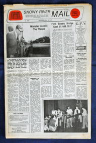
newspaper, Snowy River Mail, 1.12.1976
In early 1974, as an Engineer with the Country Roads Board, David came to Orbost as the Supervising Engineer for the construction of the new bridges which were part of an 8.4km Orbost bypass road design. This was a major project involving not only a new bridge over the Snowy River (including Lochiel Lagoon), but other bridges over Ashby’s Gulch and Watt’s Gulch. These new bridges were opened in November 1976 with the unveiling of a plaque on the eastern end of the $2.4M Snowy River Bridge. The new bridge, built by the CRB at a cost of $2.4 million, is 1.6 metres above the record flood levels of 1971. (ref. May Leatch) This newspaper contains contemporary reports of a significant event in Orbost.A Snowy River Mail newspaper, dated 1.12.1976. It contains news articles, photographs and advertisements. The main article relates to the official opening of the Snowy River Bridge and the unveiling of a plaque on the eastern approach. It also contains a history of the first Snowy River Bridge.snowy-river-bridge orbost-bridges snowy-river-mail -
Glenelg Shire Council Cultural Collection
Souvenir - Cloth Badge - Nelson Endeavour River Cruise, n.d
Cloth badge, oval, Nelson Endeavour River Cruise; light blue map of Australia, red arrow identifying Nelson; red ship's wheel either side, dark blue lettering, white background; white embroidered border on badge; white backing.Front: 'Nelson Endeavour' - above map "River Cruise' - below mapsouvenir, nelson river cruise -
 Lorne Historical Society
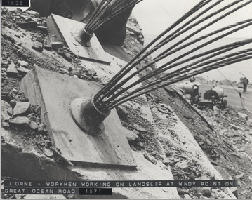
Photograph, Great Ocean Road. Windy point land slip
1971. This was some of the machinery used in stabilsing the Great Ocean Road between the St George's River and the Sheok River. Holes were drilled in the rock and large cables inserted and concrete forced in around themGreat Ocean Road. This was some of the machinery used in stabilizing the G.O.R. at Windy Point, between the St George River and the Sheoak River. Holes were drilled in the rock and large cables inserted and concrete fixed around them. This took place in late 1971great ocean road. g.o.r. landslip. windy point. 1971 -
 Orbost & District Historical Society
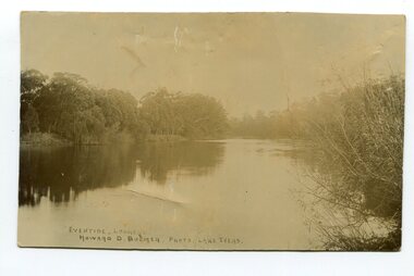
black and white photograph, Howard D. Bulmer, first half 20th century
This photograph was taken at sunset. It is of the Snowy River at Lochend.A black / white photograph of a river at sunset with thick trees and bushes on both banks. There are reflections in the water.on front - Eventide Lochend Howard D. Bulmer Photo. Lake Tyerssnowy-river lochend-orbost -
 Lakes Entrance Historical Society
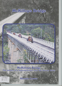
Book, Anne Bell, McKillops Bridge by Rhonda Coates
history of McKillops Bridge over the Snowy River Soft cover book by Rhonda Coates detailing the history McKillops Bridge over the Snowy River bridges, civil engineering, road construction and maintenance, topography -
 Rutherglen Historical Society
Book, Kath Bentley et al, River of Islands: Charts of the River Murray Yarrawonga Weir to Hume Dam, November 1983
Book contains information and sketch maps to aid in the navigation of the Murray River, with advice on hazards to look for as these will change over time.74 page A4 book with a drawing of a boat on the Murray River on the coverAutographed on the title page by the authors: "9-1-84 Leon Bentley | Kath Bentley"murray river, boating, river navigation, boating safety -
 Lakes Entrance Historical Society
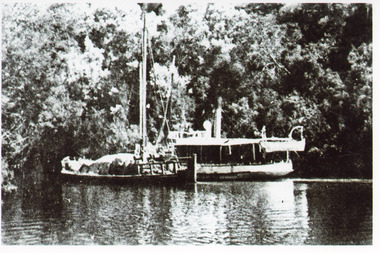
Photograph - S. S. Lady Harriet, 1908
1 x Black and white photograph copied from a book 9.5 x 14.5.Black and white photograph showing S S Lady Harriet at the cliffs on the Tambo river. The Lady Harriet barge on left of S S Harriet, well vegetated cliff behind the vessels. Swan Reach Victoria1908 S S Lady Harriet at cliffs in Tambo River and her barge (on back)jetties, ships and shipping, waterways, topography -
 Sunbury Family History and Heritage Society Inc.
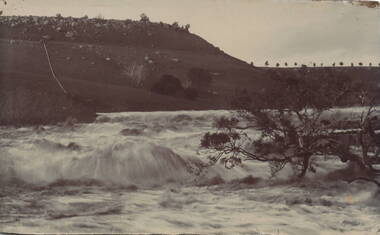
Photograph, Jacksons Creek
... Rivers ...The photograph of the waterfall tumbling over rocks in the Jacksons Creek are a feature downstream from the Macedon Street bridge and Craiglee when the there has been high rainfall. The steep escarpment on the LHS leads to Jacksons Hill and the line of trees in the distance are growing along Macedon Street (Sunbury Road).After heavy rainfall, Jacksons Creek rises suddenly and small trickles over the rocky outcrops become fast flowing waterfalls.A non-digital sepia photograph backed onto thick cardboard of a waterfall tumbling over rocks in a river with a high escarpment rising up from the watercourse. There are rocky outcrops across the hillside with a pipe down the hillside. jacksons creek, jackson hill, waterfalls, rivers -
 Port Fairy Historical Society Museum and Archives
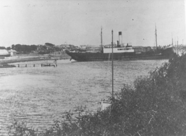
Photograph
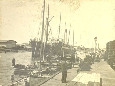
This shows the S.S.Wannon turning in the specially widened part of the river called the "turning basin" before slipping into her berth at the Belfast and Koroit Steam Navigation Company wharfBlack and white photograph of SS Wannon turning in the Moyne Rivership, boat, sea, moyne river, belfast and koroit steam navigation company, turning basin