Showing 509 items matching "soil"
-
 Orbost & District Historical Society
black / white photograph, 1897
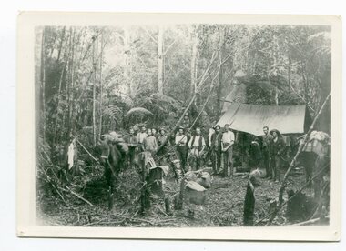
Link with item 1178. This is a surveyors' camp in the McCulloch Ranges, Murrangowar, April, 1897. Included in the photograph are: L. Thorn; Pearson; L. Coburn, Clem Bates; Sam Blacklock with a packhorse. They were surveying for a road or railway. Surveyors were among the first European settlers to arrive in Australia. A Surveyor-General was present on the First Fleet, as well as the first two ships which landed in South Australia. These men were issued with instructions to record observations in a journal that included the country’s general appearance, its soil, flora and fauna and the customs and language of local inhabitants. The conditions they worked in were harsh and they embarked on journeys with drays carrying cumbersome surveying and camping equipment, spending months camping out in the bush and mapping the land. It was not until well into the second half of the nineteenth century that the professional training of surveyors became mandatory in Australia.This is a pictorial record of a surveyors' camp in the late 19th century.A black / white photograph of a group of men standing in front of a tent / camp in a dense bush setting.surveyor's-camp-mccullochs-ranges-murrangowar land-settlement -
 Marysville & District Historical Society
Flyer (Item) - Information Flyer, Forests Commission, Victoria, FOREST WALKS - MARYSVILLE, 1918-1983
An information flyer that was produced as a guide to the forest walks in and near Marysville by the Forests Commission of Victoria. The Forests Commission Victoria (FCV) was the main government authority responsible for management and protection of State forests in Victoria, Australia between 1918 and 1983. The Commission was responsible for ″forest policy, prevention and suppression of bushfires, issuing leases and licences, planting and thinning of forests, the development of plantations, reforestation, nurseries, forestry education, the development of commercial timber harvesting and marketing of produce, building and maintaining forest roads, provision of recreation facilities, protection of water, soils and wildlife, forest research and making recommendations on the acquisition or alienation of land for forest purposes″. An extensive network of walking tracks surrounds Marysville and they offer a variety of walks ranging in various levels of difficulty. This information flyer provides information such as the level of difficulty for six suggested walks around Marysville.An information flyer that was produced as a guide to the forest walks in and near Marysville by the Forests Commission of Victoria.marysville, victoria, australia, forest walks, forests commission victoria, beauty spot walk, tree fern gully walk, michaeldene track, keppel track, woods lookout track -
 National Wool Museum
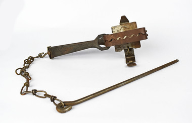
Trap, Rabbit, Henry Lane (Australia) Ltd
Steel-jawed rabbit traps were widely used in urban and rural Australia from 1880 to 1980. This trap is symbolic of the battle that Australians have waged against burgeoning rabbit populations for over a century. Despite the fact that most children first learn about rabbits as cute and cuddly animals, rabbits cause enormous damage to Australian soils and biodiversity. The introduction of rabbits to this country was an environmental disaster. Lane's Ace rabbit trap was the most commonly used trap in Australia. Hundreds of thousands of the traps were made and used in this country. As such, this item is representative of every day life in Australia during the period from 1880 to 1980. During the Great Depression from 1929 to 1932, rabbit trapping was a means of survival for many people. Rabbits provided meat and pelts which were sold for making felt hats such as the Akubra.On base of trap - "LANE'S" ACErabbit -
 Harcourt Valley Heritage & Tourist Centre
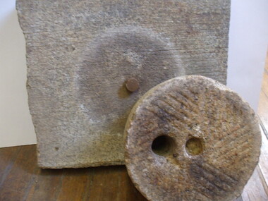
Quern, Between 1880-1920
This quern was made from Harcourt granite. Querns were used for grinding wheat into flour. (Wooden handles missing from this catalogued object).It was most likely made on Mount Alexander, in spare time, by a quarry worker using his employer’s gang saw and other tools. Wheat is not now grown in Harcourt district . Early settlers engaged in cropping until they exhausted the fertility of the soil. This quern was utilized by a local pioneer who intended to be self-sufficient to the extent of grinding his own grain into flour.. Many local farmers sowed wheat immediately after clearing the land: raising of a wheat crop was evidence of use and improvement which, along with fencing and erecting other structures, was part of the mandatory steps to prove occupancy as a prelude to obtaining a Crown Grant for what had previously been deemed ‘crown land'The quern is of interest as a symbol of the desire for self-sufficiency and as a demonstration of the extent to which granite could be worked and shaped by masonry tools. Quern, granite, square slab with raised metal centre shaft and one rounded piece of granite with off-centre hole and side ridges. -
 Geoffrey Kaye Museum of Anaesthetic History
Book, Longman, Brown, Green and Longmans, Physical Description of New South Wales and Van Diemen's Land. Accompanied by a geological map, sections, and diagrams, and figures of the organic remains, 1845
Dr. Gwen Wilson, Emeritus historian, gifted this book at ANZCA's first independent Annual Scientific Meeting held in Launceston in 1994. Dr Wilson presented this gift after her speech about the life of William Russ Pugh and his significant contribution to anaesthesia in Australia. It is unclear as to how the book came into Dr Wilson's possession. Published in London, 1845, for Longman, Brown, Green and Longmans, this book was formally owned by general practitioner Dr William Russ Pugh, being the first medical practitioner in Australia to administer ether anaesthetic on 7 June 1847, in Launceston. The author of the book, P E De Strzelecki acknowledges Pugh for his assistance during his stay in Launceston and for allowing him the use of his laboratory for the analysis of the soils and minerals that were subsequently reported in this book (Page 131). Tan coloured cloth book with an embossed circular motif on the centre of the front and back cover. The same embossed motif is repeated four times along the spine of the book. An embossed design of small, four petal flowers borders the edge of the front and back cover. The title of the book 'Strzelecki's New South Wales and Van Diemen's Land' is printed in gold on the spine. The cloth has come unstuck at various places around the spine and a small section is missing from the base of the spine. The cover is worn and has numerous dark stains possibly from mould. The book contains 19 engraved and lithographed plates. This includes a handcoloured octavo folding, geological map, bound as a frontispiece, depicting the NSW coast down to Gippsland and Tasmania, a fold out single colour geological cross section of the Newcastle Coal Basin, 14 plates illustrating shellfish and flora and three tinted lithographs. Single page maps at the back illustrate wind patterns around Australia. [front title page, two black ink stamps that have bled through to the next page] W R.PUGH [front title page, black ink, cursive writing] H Grant \ 5 May 1910 [front title page, pencil, cursive writing, written around Pugh's stamp] Purchased from \ (unrecognizable script) [front title page, previous owner's name was rubbed out and consequently tore the page making the entry unreadable] [Inner back cover, bottom LHS, blue stamp] BOUND BY \ WESTLEYS & \ CLARK \ LONDON [Inner front cover, bottom LHS, black and purple ink] P65 \ 76 \ 78 \ 98 \ 163 \ 164 \ 217strzelecki, van diemen's land, wilson, gwen, pugh, william, launceston, green and longmans -
 Wooragee Landcare Group
Photograph, 27 August 2004
This photograph was taken on Friday the 27th of August 2004 as part of an event called 'Direct Seeding Expo'. This event was one of many held by the Wooragee Landcare Group in the early 2000s which aimed to educate the local community on certain agricultural and biodiversity conservative techniques. This particular event took place across three different locations - Wooragee Hall, and direct seeded sites at the properties of Marcus and Lisa O'Connor, and Neil and Anne Nankervis - and, therefore, the exact location where this photograph was taken is unknown. Three different direct seeding techniques were demonstrated during the day by several experts in the field. Direct seeding involves the sowing of seeds directly into the soil to achieve germination and establishment. It is an alternative to planting seedlings in a contained nursery plot. This direct method is intended to mimic a more natural process of growth, revegetating larger areas in a more efficient manner. This photograph is significant as it provides evidence of a project undertaken by the Wooragee Landcare Group in the early 2000s to educate members of the public on alternative and potentially more efficient methods of planting seedlings. The Wooragee Landcare Group has been instrumental in the co-ordination of programs relating to biodiversity protection in the local area, providing great assistance to landholders.Landscape coloured photograph printed on gloss paperReverse: WAN NA EOWA2N2 ANN- 1 4240 / neil and anne nankervis, marcus and lisa o'connor, wooragee hall, wooragee landcare, wooragee landcare group, direct seeding expo, direct seeding, seeds, revegetation, alternative planting -
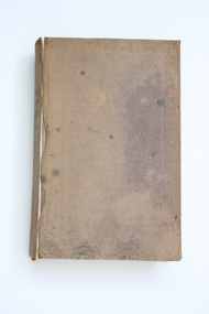
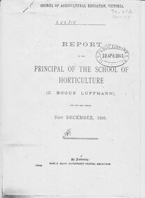 University of Melbourne, Burnley Campus Archives
Document - Report, photocopy, Charles Bogue Luffman, Report by The Principal of School of Horticulture 1899, 1899
This is a photocopy of the original report. The report is headed "Council of Agricultural Education, Victoria". At this time the Burnley School of Horticulture was under the aegis of the Council of Agricultural Education. Photocopy of Annual Report by C. Bogue Luffmann, 2 copies Annual Report, an examination paper and essays on horticultural subjects by C. Bogue Luffmann and several students. It is 39 pages, contains an annual report, an examination paper and essays on horticultural subjects, by C Bogue Luffmann and also by several students. These essays include: The prospectus of commercial fruit growing in Victoria - C Bogue Luffmann - principal The economy of design in fruit trees - C Bogue Luffmann How to choose, prepare and maintain fertility in orchard and garden soil - Tessa Smith - 1st year student Villa Gardening - Marian W Thompson - 1st year student Lemon culture - Florence Jacomb - 1st year student - and MW Thompson An examination paper - FJ Wilmoth - 1st year student Appendix: Select list of 12 leading fruits suitable for local and export marketscharles bogue luffman, principal, students, horticulture, horticulture school report, villa gardening, lemon culture, fruit trees, horticulture writing 19th century, turn of the century, 1899 horticulture school, luffmann -
 Keilor East RSL Sub Branch
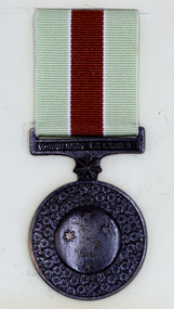
Medal - Civilian Service Medal 1939-45
Replica medal with pale lime green with red centre ribbon, mounted on promotion card with notes.Promotional card reads: The Governor-General awards the Civilian Service Medal 1939-1945 on the recommendation of the Prime Minister or delegate. / The Civilian Service Medal 1939-1945 is bronze and portrays the Southern Cross surrounded by golden wattle , Australia's floral emblem. / The Southern Cross represents Australia and the golden wattle represents the civilian population joining in defence of the country. / The medal ribbon has three vertical bands. The central band is ochre to represent the soil of Australia. / The two outer bands are green for the land and food production. The two white stripes on the ribbon represent communication and construction. civilian, 1939-45, australian -
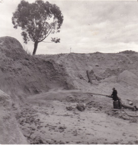 The Beechworth Burke Museum
Photograph
This photograph depicts a man in dark clothing, standing in front of a cut away section of earth. He is undertaking hydraulic sluicing, which involves the use of high powered hoses, in order to cut away the earth which can then be sifted for gold. There is a single tree in the background and the earth contains numerous signs of damage because of the mining. Beechworth become a mining settlement after the discovery of gold in 1852. Gold fever had already spread across Australia's colonies and the American states. Sluicing the landscape for gold, as shown in this photograph, was done by diverting water and washing away the lighter dirt, allowing the gold particles to sift down in to catchments for collection. In Beechworth, there was considerable discontent caused by attempts to restrict water use for sluicing to those with certain 'water rights'. The extensive use of hydraulic sluicing, and the washing away of top soils has continued to impact the surrounds of Beechworth in to the present day. Sluicing as a method for gold mining which was widespread across Victoria during the 1870s. The erosion of the top soil in search of gold has a continuing environmental impact on the landscape and this photograph depicts but one example of this occurring and can provide much information to a researcher interested in understanding the history of gold mining in Victoria. This image of the miner and hose is historically important because it demonstrates the methods of goldmining employed in the later years of the goldrush at Beechworth. It shows how much land is washed away by the use of this technology. The image has good interpretive capacity because it allows researchers to see a different mining technique to what is usually presented. Black and white square photograph on card.reverse: 84-50-3 / 1997 3141 / smdsluicing, goldmining, beechworth, burke museum, miners, gold miners, gold sluicing, environmental impact -
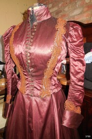 Flagstaff Hill Maritime Museum and Village
Clothing - Jacket, before April 1874
THE JACKET This jacket has been tailored to flatter the wearer’s figure. It also has elements that keep it in good shape and condition, preserve it from soiling and give it a longer life: - the hooks and eyes that join the jacket to the skirt allow the outfit to be made in two pieces but fit close to the body without exposing undergarments - the seams for the metal stays have been cut and stitched to allow maximum movement of the wearer and still keep a trim figure - the discreet breast pocket allows the wearer to keep a handkerchief, coins or other small items close at hand - the lining includes removable padded shields to absorb underarm perspiration - the lining has two cotton loops attached for hanging up to air and freshen it - new cuffs have been attached over the original sleeves that have buttonholes but no buttons. The buttons may have been used to replace missing buttons on the front of the jacket or perhaps to repair worn cuffs The amber coloured satin jacket is fully lined, has turned-back cuffs, a band collar, and looped, coffee-coloured braid trim. A row of closely spaced, round bronze buttons with a floral motif form a decorative closure most of the way down the front of the jacket, below which are metal hooks and eyes that finish at the waist. Underneath the cuffs there is a closely fitted cuff with a row of three button holes but no buttons. The jacket lining has vertical metal stays spaced around the midriff, sides and back. There is an absorbent, removable pad hand-stitched to the underarm section of each sleeve opening. A small satin pocket is stitched discreetly onto the lining above the chest on the right-hand side. There are also two cotton loops sewn onto the lining. Several small metal rings are sewn at intervals around the inside of the waist A satin bow from the same fabric is attached at the centre back of the jacket at waist level. antique satin jacket, colonial evening jacket, ladies evening jacket, 19th century ladies satin jacket, evening outfit -
 Marysville & District Historical Society
Flyer (item) - Information Flyer, Forests Commission, Victoria, Cumberland Scenic Reserve, 1918-1983
An information flyer that was produced as a guide to the Cumberland Scenic Reserve by the Forests Commission of Victoria. The Forests Commission Victoria (FCV) was the main government authority responsible for management and protection of State forests in Victoria, Australia between 1918 and 1983. The Commission was responsible for ″forest policy, prevention and suppression of bushfires, issuing leases and licences, planting and thinning of forests, the development of plantations, reforestation, nurseries, forestry education, the development of commercial timber harvesting and marketing of produce, building and maintaining forest roads, provision of recreation facilities, protection of water, soils and wildlife, forest research and making recommendations on the acquisition or alienation of land for forest purposes″. The Cumberland Scenic Reserve is set in the heart of the mountain forests of Victoria and is 16km east of Marysville on the Cumberland Road. This reserve forms part of the catchment of Armstrong Creek, a tributary of the Yarra River which provides water for the Melbourne area. The reserve is a prime mountain ash area in which is set the old Cambarville sawmill and village site.An information flyer that was produced as a guide to the Cumberland Scenic Reserve by the Forests Commission of Victoria. 423Aforests commission victoria, cumberland scenic reserve, marysville, victoria, cambarville, the big tree, cora-lyn falls, barton's lookout, cumberland falls, sovereign view, armstrong creek, yarra river, mountain ash -
 Ballarat Heritage Services
digital copy, Ballarat East High School Magazine 1960, 1960
School History: In February, 1955, Ballarat East High School opened in Hopetoun Street, in the vacated weatherboard buildings of the Girls’ Secondary School. In 1956, however, the School moved to its present site in Fussell Street, but because of the lack of space, Woodwork and Cookery classes were still held at Hopetoun Street. Since then there has been steady progress. The original building was extended, more classrooms and a library being built. A Domestic Science block was completed in 1957. Later, as mentioned elsewhere, sheltersheds, basketball courts, a bidycle shed and a canteen were provided for the pupils from funds raised by the Parents’ Association. Where there were previously bare areas of clayey soil we now have asphalt paths and neat gardens. Shrubs were planted, and seats, painted in the School colours, were places around the asphalted areas. (Page 5, 1959 BEHS School Magazine) 3 pdf files containing multiple pages of the BEHS 1960 School Magazinebehs, ballarat east high school, ballarat east, magazine, 1960 -
Ballarat Heritage Services
digital copy, Ballarat East High School Magazine 1961, 1961
School History: In February, 1955, Ballarat East High School opened in Hopetoun Street, in the vacated weatherboard buildings of the Girls’ Secondary School. In 1956, however, the School moved to its present site in Fussell Street, but because of the lack of space, Woodwork and Cookery classes were still held at Hopetoun Street. Since then there has been steady progress. The original building was extended, more classrooms and a library being built. A Domestic Science block was completed in 1957. Later, as mentioned elsewhere, sheltersheds, basketball courts, a bidycle shed and a canteen were provided for the pupils from funds raised by the Parents’ Association. Where there were previously bare areas of clayey soil we now have asphalt paths and neat gardens. Shrubs were planted, and seats, painted in the School colours, were places around the asphalted areas. (Page 5, 1959 BEHS School Magazine) 3 pdf files of multiple pages of BEHS School magazine=1961 behs, ballarat east high school, ballarat east, magazine, 1961 -
Ballarat Heritage Services
digital copy, Ballarat East High School Magazine 1962
School History: In February, 1955, Ballarat East High School opened in Hopetoun Street, in the vacated weatherboard buildings of the Girls’ Secondary School. In 1956, however, the School moved to its present site in Fussell Street, but because of the lack of space, Woodwork and Cookery classes were still held at Hopetoun Street. Since then there has been steady progress. The original building was extended, more classrooms and a library being built. A Domestic Science block was completed in 1957. Later, as mentioned elsewhere, sheltersheds, basketball courts, a bidycle shed and a canteen were provided for the pupils from funds raised by the Parents’ Association. Where there were previously bare areas of clayey soil we now have asphalt paths and neat gardens. Shrubs were planted, and seats, painted in the School colours, were places around the asphalted areas. (Page 5, 1959 BEHS School Magazine)4 pdf files holding multiple pages of BEHS 1962 School Magazines. These are large pdf files being each around 20MB or largerbehs, ballarat east high school, ballarat east, magazine, 1962 -
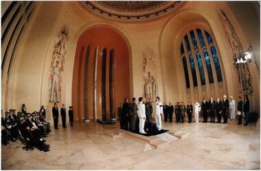 Melbourne Legacy
Photograph - Australian War Memorial, The Unknown Soldier, 1993
A photo of the internment of the coffin of the Unknown Australian Solider in the Hall of Memory at the Australian War Memorial in Canberra. The coffin is flanked by pall bearers from each of the defence forces. The official Party, including the Prime Minister, Hon Paul Keating MP, looks on and veterans are seated. There are two Junior Legatees present, they were Rebecca and John Healey of Canberra. There was in article in The Answer newsletter in June 1994. The Unknown Australian Soldier was interred in the Hall of Memory on 11 November 1993. He was buried in a Tasmanian blackwood coffin, on which were placed a bayonet and a sprig of wattle. Soil from the Pozières battlefield in France was scattered in his tomb. The tombstone later placed on top of the tomb has the inscription: “An unknown Australian soldier killed in the war of 1914–1918”. At the head of the tomb is inscribed “Known unto God” and at the foot, “He is all of them and he is one of us.” (details taken from awm.gov.au)A record of Junior Legatees being present at the interring of the Unknown Soldier at the Australian War Memorial in Canberra. It shows how respected Legacy's work is by the wider community that the Junior Legatees are included in such a distinguished group at such an important event.Colour photo inside the Hall of Memory at the Australian War Memorial.australian war memorial, answer -
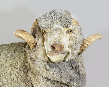 National Wool Museum
Taxidermy Sheep, Booka, c1980
The ‘Wanganella’ merino sheep stud was established by the Peppin brothers in the Riverina in 1861. The introduction of a single French ‘Rambouillet’ Merino ram, called Emperor, is now widely acknowledged as one of the most important events in the development of the Peppin stud. As many as 70% of today’s Australian Merinos are said to be directly descended from the Peppin-developed sheep. Its heavy fleece falls in the mid-range of Merino wool qualities (20 to 23 microns) and is protected from the excesses of the environment by a comparatively high content of natural wool grease, which can be seen in the creamy colour of Booka’s wool. Fred Peppin said [of the sheep breed] "We were satisfied with the type of wool that the country would grow, instead of endeavouring to produce what the climate and soil continually fight against. Thus we developed all its good natural tendencies and after that the flock had a character of its own.”Peppin merino stud. Has a large body and long legs. Two horns protruding from its skull.sheep, wanganella -
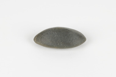 The Beechworth Burke Museum
Geological specimen - Ventifact (wind- or ice-shaped) pebble
Ventifacts are sand-blasted rocks that are typically faceted and often display parallel grooves carved by wind-blown sand. They are useful indicators of wind direction and strength in environments such as deserts, mountains, and coastal areas because they are usually not hidden by later sediment, soil or vegetation cover. In Antarctica ventifaction is strongly related to the composition or type of rock. Ventifacts are important because they provide evidence for abraders such as sand, dust or snow and ice crystals, and offer a unique understanding of past wind processes that are effective in the reconstruction of past wind flow conditions and can provides clues to weather and climate changes in the past. Interestingly ventifacts have also been found on the surface of Mars. They were a threat to the NASA rover due to the sharp angles of the facets, created by the Martian wind over the course of millions of years. These Martian ventifacts act like weathervanes for past wind and weather patterns on the red planet in a similar manner to those found on earth.The Geological Survey of Victoria was instigated in response to the Victorian Gold Rush which began around 1851 in the Beechworth, Castlemaine, Daylesford, Bendigo and Ballarat areas. The survey was conducted by Alfred Richard Cecil Selwyn from his arrival in December 1852 until his resignation in 1869and during this time he trained many notable geologists, e.g. Aplin, Wilkinson, Daintree, who went on to other State survey senior positions. This specimen was among those donated to the Burke Museum in 1868.A hand-sized solid mineral specimen in shades of dark and light browns with light lines visible in all configurations and a groove on configuration 2.light lines visible in all configurations and a groove on configuration 2burke museum, beechworth, geological, geological specimen, ventifact, antarctic region, antarctic, alfred richard cecil selwyn, alfred selwyn, wind direction, wind strength, abraders, wind flow, climate change, reconstruction of wind flow conditions, weather change, mars -
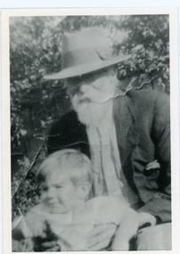 Mt Dandenong & District Historical Society Inc.
Photograph, Edward Joseph Price and Grandson
John Lundy-Clarke grew up in the Kalorama/Mt Dandenong area and later in life (1972-74) began to write a comprehensive history of the district working from an original settlement map in an effort to cover all areas. Edward Joseph Price took out Lot 1, Section 1 of the Village Settlement and became the first settler, moving his family up into a slab hut on his selection in 1896. Edward Joseph had two sons (Charles Joseph and Edward John) and a daughter (Kathleen Nathalie Caroline). Edward Joseph Price is holding his grandson Teddie, son of Edward John Price. Photo taken 1936.Black and white photograph in close up showing an old man with a white beard wearing a brimmed hat holding a male toddler under the arms. Reverse of photograph has handwritten description by John Lundy-Clarke.Edward Joseph Price and his grandson Teddie son of Edward John. E. Joseph was the first settler in the Village Settlement choosing LOT 1, part of which is still family property (1974). He worked for the surveyors who were marking out the blocks, and disregarded their advice as to which had the best soil, and so doing he obtained the best commercially. He died in 1943 leaving two sons & daughter. Edward John born 1899 died 1974. Charles born 1892 died 1958. Kathleen born 1895 died 1954. Wife Annie nee Ross died 1932.edward joseph price, edward john price, teddie price -
 The Beechworth Burke Museum
Animal specimen - Spotted Pardalote, Trustees of the Australian Museum, 1860-1880
The spotted pardalote is the smallest of all Australian birds. It has a tendency to nest in a long horizontal tunnel, often dug into the soil of creek banks, the embankments of railway cuttings, and quarries. Its call is characterised by a very clear and repetitive double "ding". The spotted pardalote is common in woodlands and eucalypt forest areas in Australia. This specimen is part of a collection of almost 200 animal specimens that were originally acquired as skins from various institutions across Australia, including the Australian Museum in Sydney and the National Museum of Victoria (known as Museums Victoria since 1983), as well as individuals such as amateur anthropologist Reynell Eveleigh Johns between 1860-1880. These skins were then mounted by members of the Burke Museum Committee and put-on display in the formal space of the Museum’s original exhibition hall where they continue to be on display. This display of taxidermy mounts initially served to instruct visitors to the Burke Museum of the natural world around them, today it serves as an insight into the collecting habits of the 19th century.This specimen is part of a significant and rare taxidermy mount collection in the Burke Museum. This collection is scientifically and culturally important for reminding us of how science continues to shape our understanding of the modern world. They demonstrate a capacity to hold evidence of how Australia’s fauna history existed in the past and are potentially important for future environmental research. This collection continues to be on display in the Museum and has become a key part to interpreting the collecting habits of the 19th century. One of Australia's smallest native birds, the male spotted pardalotte is covered with small, distinct white spots. Males have a pale eyebrow, a yellow throat and a red rump. Females are similar but have less-distinct markings. 10060 comprises of one male and one female. This specimen stands upon a wooden platform and has an identification tag tied around its legLabel: 14a. / Spotted Diamond Bird / See Catalogue, page 9. /taxidermy mount, cancel, taxidermy, burke museum, beechworth, australian museum, bird, spotted pardalote -
 The Beechworth Burke Museum
Photograph, est. 1860-1875
In 1875, the Rocky Mountain Extended Gold Sluicing Company Ltd was created, utilising the previous Rocky Mountain claim for the area near Lake Sambell. The company employed A.L Martin to survey an area for a tunnel underneath Beechworth and Johnson Stephens to dig it. The tunnel was built at a rate of 40 feet a month and eventually measured 800 metres. The tunnel was a true accomplishment both in the present and during the 19th century. It was considered to be a marvelous engineering feat. Beechworth is renowned for its hydraulic sluice method of mining. This involved soil being exposed to torrents of water from high-pressure hoses. From 1876 until its closure in 1921, the mine produced an astounding 47,926 ozs of gold. Companies like this were the source of income for many Chinese gold-diggers who sought to make their fortune on the goldfields of Beechworth. During the height of the rush, the town had around 7,000 Chinese inhabitants living on the outskirts of town as they were not permitted to live within Beechworth itself.The search for gold is ingrained into the history of Victoria and therefore, images like this one which portrays an open-cut sluicing site can reveal important information for society and technology for the date when the photograph was taken. This image is of important historical significance for its ability to convey information about sluicing and the methods used to find gold in 1910. It also shows a location where sluicing was undertaken which provides insight into the impact of sluicing on the environment at a time when it was done. This image of the Rocky Mountain mine is historically significant as the mining complex is now non-existent, with the only remains being the tunnel built in 1880 by the company, which was considered one of the greatest engineering feats of the time. The image also provides a first-hand look into the social and cultural networks at play during the 19th century with racial segregation of the Chinese at the 'Chinese Camp', as well as an insight into Beechworth's origins during the Gold Rush.A sepia rectangular photograph printed on matte photographic paper as a postcardReverse: Historic Beechworth / 7792.1 / ROCKY MOUNTAIN MINE / Viewed from the “Chinese Camp”, shown partly in the foreground, we see the central plant of the famous Rocky Mountain Mining Company. This extensive complex, of which nothing remains, was situated between Silver Creek and the present Lake Sambell area. The company was responsible for a tunnel cut through solid bedrock underneath the town of Beechworth and surfacing near the keystone bridge on the Wangaratta side. Completed in 1880 it was declared to be one of the greatest engineering feats in Australia. The tunnel is still basically intact today. / Series by Wooragee Graphics: Historic Beechworth. / COPYRIGHT BURKE MUSEUM / No.72 beechworth, rocky mountain mine, sluicing, gold rush, mining, gold -
 City of Moorabbin Historical Society (Operating the Box Cottage Museum)
Document,photocopy plan 'Two Acre Village 'c1852, c1960
In the 1852 Josiah Holloway, a developer, purchased 625 acres from the squatters Richard and John King and sectioned '2 acre allotments' south of Henry Dendy's Brighton Survey along the Arthur's Seat Road ( later Nepean Highway) for sale @ £10 It became known as The Two Acre Village as settlers took up the allotments and established market gardens, general stores, butchers, blacksmiths, post office and 2 hotels. Charles Whorral opened The Cheltenham Inn and it became so popular as a meeting place that the area was called Cheltenham. The early settlers, who were predominantly English and Scottish immigrants initially leased their allotments and, because the sandy soil was so fertile, they were soon able to purchase the land and increase their acreage. Cheltenham became a very important part of the large Moorabbin Shire1871 and City of Moorabbin 1934 In the 1994 Amalgamation of Councils, when the large City of Moorabbin was divided between the newly formed Glen Eira, Kingston and Bayside Councils, the Cheltenham area was assigned to the City of Kingston A photocopy of the Plan for the 2 Acre Village in Moorabbin Parish c1852. A3 laminatedmoorabbin, brighton, cheltenham, market gardeners, pioneers, early settlers, , king. john, holloway josiah, whorral charles, arthur’s seat road, nepean highway , cheltenham inn hotel, henry dendy special survey 1841 -
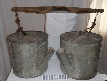 City of Moorabbin Historical Society (Operating the Box Cottage Museum)
Tool - Chinese Market-Gardener's Watering-Cans
Chinese market-gardener’s watering-cans on a wooden yoke. This item was authenticated by the Bendigo Historical Society, and is said to be quite rare. It consists of two large galvanized watering-cans each with a pouring spout, suspended by chains from a well-used wooden yoke. The cans would each have been filled with water, then carried a distance into the market garden and used to water crops. The cans and yoke alone are very heavy, one can only imagine how heavy they were when filled with water.As profits from the gold-fields petered out the Chinese immigrants, (nearly all single men), were forced to seek other occupations. Many moved into furniture building in the East Melbourne area, whilst others went into market gardening . A significant number of Chinese men, realising the potential of the sandy, fertile soil, with a good supply of water, in the Shire of Moorabbin, leased tracts of land in that area to establish a market garden and grow produce for the increasing population of MelbourneAfter the Dendy Special Survey in1841in Brighton, Victoria, the first sale of Crown Land, taking in the whole Shire of Moorabbin, occurred in 1852. These allotments of land were eagerly bought up - some by speculators - although many were either worked by the owner, or leased out as market gardens and "fruit gardens", (orchards). Chinese market-gardener’s watering-cans suspended by chains on a wooden yoke. This item was authenticated by the Bendigo Historical Society, and is said to be quite rare. It consists of two large galvanized watering-cans each with a pouring spout, suspended by chains from a well-used wooden yokebrighton, gardeners, bentleigh, orchards, vegetables, dendy henry, market gardens, chinese settlers, pioneers moorabbin, water wells, creeks -
 Wodonga & District Historical Society Inc
Photograph - Codling Collection 01 - Wodonga's Second Police Station
Miss Olive Codling was a Foundation Member and a Life Member of the Wodonga Historical Society. Many of her prize-winning photos are held in the Society Collection. She also held a range of roles and committee positions in a wide range of Wodonga community organisations. WODONGA'S SECOND POLICE STATION - This building was located on the west side of High Street near the railway line at the corner of High Street and Bond Street. The building in the background was the Bond Store which was later repurposed to become the Court House. This Police Station, which began operation on this site c1905, had originally been the house of the customs officer. It had a front office and a Sergeant's and an Inspector's office as well as 2 barrack rooms and a laundry at the rear. In the backyard was a blue stone cell block and a night soil toilet, as well as a stable used previously for horse and carriage. Opposite the police station was a boarding house which supplied meals to prisoners. This police station was in use until its move to Elgin Street, Wodonga in December 1967.This photo collection is significant as it documents how the businesses and buildings in Wodonga have evolved and contributed to community throughout the 20th century.Two black and white photos of the 2nd Police Station built in Wodonga with the former Bond Store in the background.high st wodonga, police stations wodonga -
Ballarat Heritage Services
Magazine - digital copy, Ballarat East high School Magazine 1959, 1959
Ballarat East High School was established in the early 1950s. This is one of the earliest magazines produced. School History: In February, 1955, Ballarat East High School opened in Hopetoun Street, in the vacated weatherboard buildings of the Girls’ Secondary School. In 1956, however, the School moved to its present site in Fussell Street, but because of the lack of space, Woodwork and Cookery classes were still held at Hopetoun Street. Since then there has been steady progress. The original building was extended, more classrooms and a library being built. A Domestic Science block was completed in 1957. Later, as mentioned elsewhere, sheltersheds, basketball courts, a bidycle shed and a canteen were provided for the pupils from funds raised by the Parents’ Association. Where there were previously bare areas of clayey soil we now have asphalt paths and neat gardens. Shrubs were planted, and seats, painted in the School colours, were places around the asphalted areas. (Page 5, 1959 BEHS School Magazine) 3 pdf files holding multiple pages of 1959 School Magazinebehs, ballarat east high school, ballarat east, magazine, 1959 -
 Federation University Historical Collection
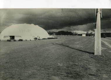
Photograph, Binishell, c1980
Binishells are reinforced concrete thin-shell structures that are lifted and shaped by air pressure. They were invented in the 1960s by Dante Bini, who built 1,600 of them in 23 countries.Colour photograph of a distinctive architectural feature known as a Binishell on the Gippsland campus. The large reinforced concrete dome is shaped and lifted by air pressure. Its inventor, architect Dr. Dante Bini, directed the construction of the Binishell in December 1979. The eleven metre high binishell, used 300 tons of concrete and reinforcing steel, was inflated by a large membrane in around one hour, using Dr. Dante Bini's ferrocement method. The Binishell was used as a place for exams and graduations. Reactive clay in the soil caused the footings of the binishell to twist, subsequently causing the shell to crack. The resulting damage diminished structural integrity, resulting in the Binishell not being used in 2004 and early 2005 while a new structure support was installed. Normal use of the building was resumed in Semester 1 2005. Eventually the external thermal membrane started to fail, and on 14 February 2009, the Binishell was demolished, with new auditorium built at the campus for classes, graduation ceremonies, exams and conferences.gippsland campus collection, binishell -
Kew Historical Society Inc
Archive (Sub-series) - Subject File, Kew, City of - Management, 1958
City of KewReference, Research, InformationKHS Imposed OrderKew in Victoria was declared a City in 1921, and remained so until it was amalgamated into the City of Boroondara in 1994. This is a single large archive file, primarily comprised of Kew Council documents, a number of which date from an earlier period. Interesting early primary sources include: 1914 Amendments to the Local Government Act of 1903 [copy owned by Mr W.J. Muntz C.E.]; a Cleansing Contract [for the removal of night-soil] (1913); an Annual Statement of Accounts (1923); and By-Law No.66 (1939) [relating to the “Erection Construction and Removal of Buildings, Advertising Signs, Etc.”; and the Councillor’s Handbook (1939). In addition to these, later publications relate to Financial Statements (1986, 1987, 1988); Model Local Laws (1989); a Municipal Emergency Management Plan (1990); Mobile Bin Recycling Trial (1991); a School Project Kit (1991-2); and Committee Minutes (1992). There are also a number of newspaper articles/clippings on Council management issueslocal government - kew (vic) - publications, city of kew - management, city of kew - amendments to the local government act 1903, city of kew - by-laws, city of kew - financial statements, city of kew - councillor's handbook, city of kew - municipal emergency management plan 1990, city of kew - mobile bin recycling trial (1991)local government - kew (vic) - publications, city of kew - management, city of kew - amendments to the local government act 1903, city of kew - by-laws, city of kew - financial statements, city of kew - councillor's handbook, city of kew - municipal emergency management plan 1990, city of kew - mobile bin recycling trial (1991) -
 Kew Historical Society Inc
Plan - Subdivision Plan, Normanby Heights Estate, Kew, 1919
Prue Sanderson, in her groundbreaking ‘City of Kew Urban Conservation Study : Volume 2 - Development History’ (1988), summarised the periods of urban development and subdivisions of land in Kew. The periods that she identified included 1845-1880, 1880-1893, 1893-1921, 1921-1933, 1933-1943, and Post-War Development. These periods were selected as they represented periods of rapid growth or decline in urban development. An obvious starting point for Sanderson’s groupings involved population growth and the associated economic cycles. These cycles also highlighted urban expansion onto land that was predominantly rural, although in other cases it represented the decline and breakup of large estates. A number of the plans in the Kew Historical Society’s collection can also be found in other collections, such as those of the State Library of Victoria and the Boroondara Library Service. A number are however unique to the collection.The Kew Historical Society collection includes almost 100 subdivision plans pertaining to suburbs of the City of Melbourne. Most of these are of Kew, Kew East or Studley Park, although a smaller number are plans of Camberwell, Deepdene, Balwyn and Hawthorn. It is believed that the majority of the plans were gifted to the Society by persons connected with the real estate firm - J. R. Mathers and McMillan, 136 Cotham Road, Kew. The Plans in the collection are rarely in pristine form, being working plans on which the agent would write notes and record lots sold and the prices of these. The subdivision plans are historically significant examples of the growth of urban Melbourne from the beginning of the 20th Century up until the 1980s. A number of the plans are double-sided and often include a photograph on the reverse. A number of the latter are by noted photographers such as J.E. Barnes.The Normanby Heights Estate not unusually used hyperbole to attract purchasers to the auction of 17 lots facing Argyle Street (sic), Pleasant Avenue and Normanby Road. Predictably factors appealed to included the proximity to schools etc, the availability of public utilities, friable soil, picturesque views and ‘advancing settlement’. If that were not enough, the sales pitch exhorted prospective purchasers to consider their backbone. ‘Thrift is unquestionably the Backbone of any Nation. No better form of Thrift can be encouraged in the young citizen than by investing his or her savings in a piece of land in a growing, healthy and beautiful locality. NORMANBY HEIGHTS ESTATE admirably fits the need.’ The experience of Australia at war undoubtedly contributed to the use of terms such as ‘Backbone of a Nation’ and the appeal to egalitarian principles in the choice of the term ‘young citizen’. The recognition that women had savings and might be the prospective purchaser also reflects a new sense of the rights and entitlements of women in the postwar period.subdivision plans - kew, normanby heights estate, pleasant avenue, normanby road, argyle street -
 Bayside Gallery - Bayside City Council Art & Heritage Collection
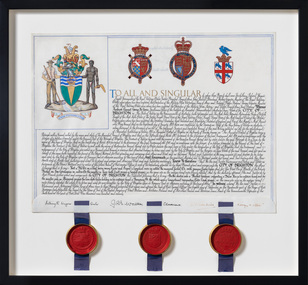
Document - Certificate, College of Arms, City of Brighton Coat of Arms, 1970
The Coat of Arms, represents Brighton City Council's "growing awareness of the importance of formality and correct symbolism in local government". It replaced the council's crest of a pier and yachting scene and was used as council's seal, and emblem on its flag and letterhead. The new Coat of Arms, drawn up by the College of Arms in England, depicts the progression from a seaside gardening community to a modern residential city. The prominent forms are on the shield-like coat of arms include waves and a Lymphad (a ship, symbolic of the sea); a market gardener; an aboriginal man; two horns plenty with abundant fruit and vegetables (the wealth and plenty) and Elster Creek. It is underscored by the motto 'By their fruits, ye shall know them'. Brighton was first incorporated as a borough on 18 January 1859, it became a town on 18 March 1887 and was proclaimed a city on 12 March 1919.Ink and gouache on parchment with wax seals. Allocates a Coat of Arms to the City of Brighton, by the College of Arms in London on 08/09/1970. The Coat of Arms is located on the upper left quadrant and has the following parts: the crest, the wreath, the helmet and mantle, the shield, the supporters, the compartment and the motto. The crest is two cornucopias with fruits and vegetables, above which sits a seagull. The mantle above the helmet is in green and gold. The shield is also green and gold with a lymphad (ship), and blue and white waves, representing the sea. The market gardener, holding a hoe, and Aboriginal figure, bearing a boomerang, support the shield and stand upon the compartment which is soil with a representation of Elster Creek. A ribbon below contains the motto in 'FRUCTU NOSCITUR'. The certificate text explains the origins of Brighton and the parts of the coat of arms. At the bottom of the folded parchment are three signatures and titles, below which three red wax seals in gold tin containers hang from blue ribbons.coat of arms, certificate, city of brighton, college of arms, market gardener, aboriginal, wax seal, elster creek, lymphad, fructu noscitur, letters patent, armorial bearings, heraldry, seal -
 The Beechworth Burke Museum
Photograph - Photograph - Reproduction
The photograph is a reproduction of a postcard from the Rocky Mountain Mining Company. In 1875, the Rocky Mountain Extended Gold Sluicing Company Ltd was created, utilising the previous Rocky Mountain claim for the area near Lake Sambell. The company employed A.L Martin to survey an area for a tunnel underneath Beechworth and Johnson Stephens to dig it. The tunnel was built at a rate of 40 feet a month and eventually measured 800 metres. The tunnel was a true accomplishment both in the present and during the 19th century. It was considered to be a marvelous engineering feat. Beechworth is renowned for its hydraulic sluice method of mining. This involved soil being exposed to torrents of water from high-pressure hoses. From 1876 until its closure in 1921, the mine produced an astounding 47,926 ozs of gold. Companies like this were the source of income for many Chinese gold-diggers who sought to make their fortune on the goldfields of Beechworth. During the height of the rush, the town had around 7,000 Chinese inhabitants living on the outskirts of town as they were not permitted to live within Beechworth itself.This image of the Rocky Mountain mine is historically significant as the mining complex is now non-existent, with the only remains being the tunnel built in 1880 by the company, which was considered one of the greatest engineering feats of the time. The image also provides a first-hand look into the social and cultural networks at play during the 19th century with racial segregation of the Chinese at the 'Chinese Camp', as well as an insight into Beechworth's origins during the Gold Rush.Black and white rectangular reproduced photograph printed on paperbeechworth, rocky mountain mine, sluicing, gold rush, mining, gold -
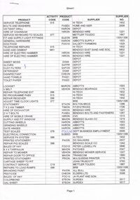 Bendigo Historical Society Inc.
Document - BENDIGO SALEYARDS COLLECTION: LIST OF SUPPLIERS
Two pages of list of suppliers. Page is divided into Five columns - Product, Activity Code, Product Code, Supplier and Supplier No. Products include stationary, hire of equipment, branding pasint, hay, glass, electrical work, repairs, dog food, testing of scales, grinding and cutting wheels. Suppliers were Hi Tech, Hume & Iser, Bendigo Hire, Mettler Toledo, BRB, Abbotts Supply, Dalgety Farmers, Bendigo East Sand and Soil, Bendigo Bearings, Bolton Bros, Fitzpatricks, Bendigo Bolts and Fasteners, CVC, Bendigo Glass Co, Dept Business Employment, DG Walkers, Bendigo Scale Co, Peter Llewellyn, Patches, Bendigo Mower Service, Transcom, Mulqueens Printer, John Truscott, All Bull, Elders Ltd, J H Plant and Son, Surdex, Obriens Glass, W C and H M Bury, BOC Gases, Windscreen City, Cleanaway, RJ and E R Conroy, J Blackwood & Sons.bendigo, council, cattle markets, bendigo saleyards collection - list of suppliers, hi tech, hume & iser, bendigo hire, mettler toledo, brb, abbotts supply, dalgety farmers, bendigo east sand and soil, bendigo bearings, bolton bros, fitzpatricks, bendigo bolts and fasteners, cvc, bendigo glass co, dept business employment, dg walkers, bendigo scale co, peter llewellyn, patches, bendigo mower service, transcom, mulqueens printer, john truscott, all bull, elders ltd, j h plant and son, surdex, obriens glass, w c and h m bury, boc gases, windscreen city, cleanaway, rj and e r conroy, j blackwood & sons