Showing 8617 items matching "south road"
-
 Eltham District Historical Society Inc
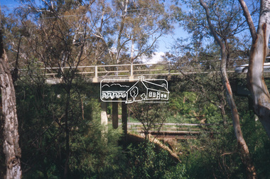
Slide - Photograph, Main Road Bridge over Diamond Creek, Eltham South, c.Nov. 2001
... Society meeting of 14 Nov. 2001 Eltham South main road bridge 35mm ...Part of a slide show presentation "A Trip Down the Diamond Creek" by Russell Yeoman to the Eltham District Historical Society meeting of 14 Nov. 200135mm colour positive transparency Mount - Black and Whiteeltham south, main road bridge -
 Eltham District Historical Society Inc
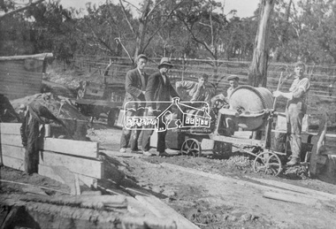
Photograph, Construction of the new concrete bridge over the Diamond Creek on Main Road, Eltham, c.May 1926
... south main road bridge wingrove park antoinette boulevard ...Construction of the new concrete bridge over the Diamond Creek on Main Road, Eltham, c.May 1926. Viewed from northern approach looking east, the access drive running off Antoinette Boulevard parallel to Main Road is visible as well as the power lines that used to run in front of Eltham Park (Eltham Lower Park). Also visible is a tree situated beside the roadway. It is believed this is the same tree that remains today as a dead tree trunk immediately adjacent to the road verge armco near the corner of Antoinette Boulevard. The original long suspension bridge over the Diamond Creek on Main Road at Eltham collapsed during flooding of the Diamond Creek on October 13 and 14, 1923. The original bridge was built around 1840 for the coach road when Cobb & Co.'s coach was the only conveyance between Eltham and Melbourne. Widespread damage was done in Melbourne and surrounding areas by floods resulting from the overflow of the Yarra at many points along its banks. A temporary bridge rigged up was severely damaged by the flooding of the creek and was closed to vehicular traffic in April 1924. A new concrete bridge was constructed to replace it and by May 1926 all the concrete piles and abutments had been completed. The bridge was finally completed and opened for traffic in September 1926, almost three years after it initially collapsed.This photo forms part of a collection of photographs gathered by the Shire of Eltham for their centenary project book,"Pioneers and Painters: 100 years of the Shire of Eltham" by Alan Marshall (1971). The collection of over 500 images is held in partnership between Eltham District Historical Society and Yarra Plenty Regional Library (Eltham Library) and is now formally known as the 'The Shire of Eltham Pioneers Photograph Collection.' It is significant in being the first community sourced collection representing the places and people of the Shire's first one hundred years.Photo print 9 x 12.5 cmshire of eltham pioneers photograph collection, eltham, bridge, diamond creek (creek), eltham south, main road bridge, wingrove park, antoinette boulevard, significant tree, cement mixer, bridge construction -
 Eltham District Historical Society Inc
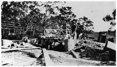
Negative - Photograph, Construction of the new concrete bridge over the Diamond Creek on Main Road, Eltham, c.May 1926
... creek (creek) eltham eltham lower park eltham south main road ...Construction of the new concrete bridge over the Diamond Creek on Main Road, Eltham, c.May 1926. Viewed from northern approach looking south east towards Eltham Park (Eltham Lower Park), showing the power lines that used to run in front of the park. The original long suspension bridge over the Diamond Creek on Main Road at Eltham collapsed during flooding of the Diamond Creek on October 13 and 14, 1923. The original bridge was built around 1840 for the coach road when Cobb & Co.'s coach was the only conveyance between Eltham and Melbourne. Widespread damage was done in Melbourne and surrounding areas by floods resulting from the overflow of the Yarra at many points along its banks. A temporary bridge rigged up was severely damaged by the flooding of the creek and was closed to vehicular traffic in April 1924. A new concrete bridge was constructed to replace it and by May 1926 all the concrete piles and abutments had been completed. The bridge was finally completed and opened for traffic in September 1926, almost three years after it initially collapsed.This photo forms part of a collection of photographs gathered by the Shire of Eltham for their centenary project book,"Pioneers and Painters: 100 years of the Shire of Eltham" by Alan Marshall (1971). The collection of over 500 images is held in partnership between Eltham District Historical Society and Yarra Plenty Regional Library (Eltham Library) and is now formally known as the 'The Shire of Eltham Pioneers Photograph Collection.' It is significant in being the first community sourced collection representing the places and people of the Shire's first one hundred years.Digital image 4 x 5 inch B&W Negshire of eltham pioneers photograph collection, bridge, bridge construction, cement mixer, diamond creek (creek), eltham, eltham lower park, eltham south, main road bridge -
 Eltham District Historical Society Inc
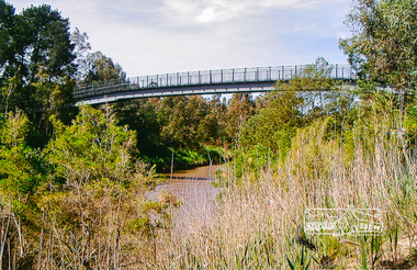
Photograph, Footbridge across the Yarra River at Eltham Lower Park
... . bridge eltham lower park eltham south homestead road lenister ...The Yarra River Footbridge was opened in August 2004 and links the Diamond Creek Trail between the Shire of Nillumbik and City of Manningham. It is a shared pathway and also links with the Main Yarra Trail. It affords lovely views over the Yarra River.Colour photographbridge, eltham lower park, eltham south, homestead road, lenister farm, yarra river, footbridge, lookout, diamond creek trail -
 Eltham District Historical Society Inc
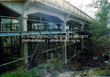
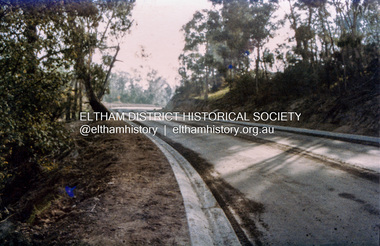
Photograph, Ruth H. Pendavingh, Reconstruction of Main Road from Main Road Bridge to Mount Pleasant Road, Eltham, 1984
... ) Eltham South Main Road main road bridge Road construction Three ...The original timber bridge over the Diamond Creek was built around 1840. It was destroyed by floodwaters in October 1923. A temporary bridge was rigged up but further damaged in April 1924. A new concrete bridge was built and opened in October 1926. The bridge decking was widened along with Main Road to Dalton Street by the Road Construction Authority in 1984. The upgraded bridge was re-opened October 25, 1984, 78 years after its original opening. (EDHS Chronology of known local events 1835- early 2000)Three colour photograph prints 1984, bridge construction, diamond creek (creek), eltham south, main road, main road bridge, road construction -
 Eltham District Historical Society Inc
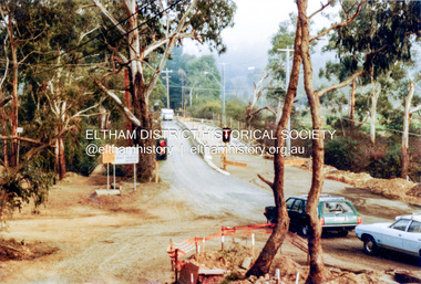
Photograph, Ruth H. Pendavingh, Reconstruction of Main Road from Main Road Bridge to Mount Pleasant Road, Eltham, 1984
... South Main Road main road bridge Road construction Antoinette ...Two colour photographs1984, bridge construction, diamond creek (creek), eltham south, main road, main road bridge, road construction, antoinette boulevard, mount pleasant road -
 Eltham District Historical Society Inc
Photograph, Ruth H. Pendavingh, Reconstruction of Main Road from Main Road Bridge to Mount Pleasant Road, Eltham, 1984
... South Main Road main road bridge Road construction Caltex ...Three colour photographs1984, bridge construction, diamond creek (creek), eltham south, main road, main road bridge, road construction, caltex service station, mount pleasant road -
 Eltham District Historical Society Inc
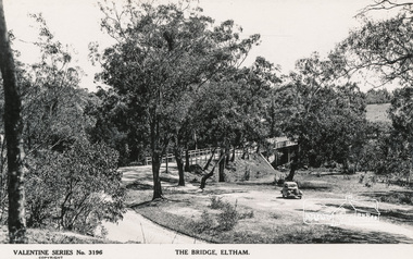
Postcard - Photograph, The Rose Stereograph Company, The Bridge, Eltham, c.1939
... Cars Eltham Eltham South Main Road Motor Vehicles Rose ...Looking west across the Main Road Bridge over the Diamond Creek at Eltham, c.1939. The car in the foreground, possibly the photographer's, is a Ford Model C Ten built by Ford UK between 1934 and 1937. The Model C was released in Australia in 1935. The Ford Model C Ten is a car that was built by Ford UK between 1934 and 1937. The Model C was released in Australia in 1935 https://en.wikipedia.org/wiki/Ford_Model_C_TenPostcardValentine Series No.3196diamond creek (creek), ford model c ten, main road bridge, postcard, valentine series postcard, bridge, cars, eltham, eltham south, main road, motor vehicles, rose stereograph, rose stereograph company -
 Eltham District Historical Society Inc
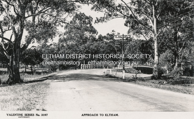
Postcard - Photograph postcard, The Rose Stereograph Company, Approach to Eltham, c.1939
... Eltham South Main Road main road bridge Postcard valentine series ...Looking east along the unsealed main road heading into Eltham across the concrete bridge over the Diamond Creek circa 1939. The original wooden bridge was destroyed by flood waters in 1924. Valentine Series No. 3197 Postcard (Michael Aitkin Collection) dated Christmas 1943Postcard Digital file only Postcards scanned from the collection of Michael Aitken on loan to EDHS, 13 Feb 2018Valentine Series No. 3197bridge, diamond creek (creek), eltham, eltham south, main road, main road bridge, postcard, valentine series postcard, michael aitken collection -
 Glen Eira Historical Society
Article - Rosstown Railway
... Caulfield South Curraweena Road Oakleigh Caulfield Technical School ...This file contains three items: 1/A review of the ROSSTOWN RAIL TRAIL from LIVING IN GLEN EIRA, vol. 11, 2004, Issue 4, no. 25, date and author unknown. The review explains the purpose of the Rail Trail with a brief narrative of the history behind Rosstown Sugar Mill Railway line. Concluding with information on the location of the Trail and the expected time required to walk the entire track included in the review is a map of the Rail Trail, which marks significant sites along the trail with historic pictures. 2/A newspaper article from THE AGE, dated Tuesday 21/10/1980 and written by Iola Matthews, reporting on the circumstances that led to the publication of the book RETURN TO ROSSTOWN written by Des Jowett and Ian Weickhardt. The article begins with a brief biography of the authors before moving into details of the book’s content, providing a further biography of W. Murray Ross which includes information on his financial ventures – particularly the Rosstown Rail – his marriage and children. The article includes a black and white photograph of Weickhardt and Jowett walking along the route of the railway line, an illustration of the Rosstown sugar works and a map of the area surrounding the site of the mill. 3/Three photocopies of a black and white illustration of the Rosstown sugar works from the east, undated and artist unknown.rosstown rail trail, rosstown, ross william, ross w. murray, ross murray, sugar beet mills, mills, elsternwick, land transport, railways, railway lines, railway routes, carnegie neville street, carnegie miller street, factories, market gardens, horticulture, peat, soils, land forms, topography, geology, civic issues, cone sugar industry, elsternwick plaza, elsternwick, glenhuntly road, parks and reserves, ee gunn reserve, caulfield racecourse, sportsgrounds, caulfield, carnegie, riddell parade, clarence street, aileen avenue, princes park, dover street, marara road, oakleigh road, rosanna street, murrumbeena crescent, north road, kooyong road, hawthorn road, booran road, koornang road, poath road, warragul road, railway platforms, railway buildings, bambra road, swamps, landforms, landfill, council landfill, railway bridges, bridges, railway underpasses, sporting clubs, tennis clubs, bowls clubs, rosstown railway, rosanna street reserve, maps, railway maps, living in glen eira, weickhardt ian, jowett des, caulfield south, curraweena road, oakleigh, caulfield technical school, return to rosstown, beet sugar industry, crops, land booms, land development and subdivisions, bent thomas, fink benjamin, sugar works, rosstown hotel, oamdenong road, rosstown dry cleaners, shops, rosstown road, rosstown plate, people by circumstance, migrants, accountants, occupations, professionals, the grange, real estate, grange road, financial agents, judges, rosstown estate, financial trouble, rabbit preserving, breweries, political debates, political issues, political electorates, politics, political science, debt, financial loans, court procedures, court cases, legal events and activities, malleson and riggall, widowers, seabeach railway, economics, economic deadline, depression 1890s, economic crash, mortgages, divorce, social problems, poverty, ross claude, ross roderick, world war 1914-1918, wars, military history, servicemen, australian flying corps, engineers, caulfield council, swagmen, homelessness, glenhuntly road, glenhuntly road tram, woornack road, leila road, wild cherry road, melten avenue, illustrations, steam trains, trains, horse and cart, horse-drawn transport, railway stations -
Glen Eira Historical Society
Newspaper - BUPA AGED CARE
... with dementia such as the garden. Caulfield South North Road Bupa Aged ...This file contains an original newspaper article (with image) titled ‘Garden Full of Memories’, dated 16/08/2011. Article describes new innovations taken place recently at Bupa Aged Care and the opening of a new dementia patient wing. The new refurbishments have been designed to engage people with dementia such as the garden.caulfield south, north road, bupa aged care, meltzer rachel, meltzer dennis, aged care, collings kathleen, gardens, nursing homes, medical sciences and health, aged people, caulfield port phillip leader -
Glen Eira Historical Society
Document - Glen Eira Residents Association
... Tramway Estate Caulfield South Ulupna Road Ormond Murray Street ...Six items pertaining to Glen Eira Residents Asssociation Inc. 1/Two copies of the minutes of a Committee Meeting of Glen Eira Residents Association Inc., held on 04/12/2001. The minutes cover a range of routine meeting items, as well as the postponed release of the Princes Park Master Plans and the proposed construction of car parks at Caulfield Racecourse. 2/A copy of Glen Eira Residents’ Association Inc.’s 30/05/2003 newsletter, notifying members of matters presently before Glen Eira City Council for purposes of evaluation. Matters include an admonishment to the Council to sort out anomalies between the C25 Amendment (80/20 Plan) and the Melbourne 2030 Plan, the success at convincing the Ministerial panel to adopt GERA’s views regarding the C14 Council Plan for the Caulfield Racecourse, a request for information from the Council regarding the previous year’s rate increase, a request for information from the Council regarding spending on planning for improvements to Princes Park, a call for the Council to improve its consultative procedures, a recommendation that the purpose of Glen Eira News be expanded to the making of suggestions for city improvement, and a notification of the measures implemented to improve the visibility of Caulfield Racecourse’s usability by the public. Includes a black-and-white photograph of Orrong Road, Elsternwick, illustrating what Glen Eira’s roads would look like if lined with trees, which was excluded from Glen Eira News on account of a current prohibition on the making of suggestions for city improvements. 3/Four copies of a booklet entitled ‘A Short Guide to Planning Procedures’, composed 08/2006, which endeavours to explain, as concisely as possible, the methodology by which Glen Eira City Council approves real estate developments and issues planning permits. 4/A booklet containing the minutes of the 05/10/2009 Annual General Meeting of Glen Eira Residents’ Association Inc. Details both routine items and more specific matters of discussion, such as inappropriate charges on the part of the Glen Eira City Council and the proposed inception of a questionnaire to evaluate local residents’ opinion of the Council. 5/A booklet announcing the 07/10/2010 Annual General Meeting of Glen Eira Residents’ Association Inc. at St. John’s Uniting Church, Elsternwick. Front cover details agenda and contains four colour photographs pertaining to public transport (buses, trams, trains) within the city. Interior features president Don Dunstan reflecting on issues relevant to GERA occurring over the preceding twelve months, with an emphasis on the dubious behaviour of the City Council, as well as two colour photographs: one of Dunstan himself and one of traffic at Elsternwick Junction. The rear cover contains the Financial Statement presented to the Meeting. 6Two copies of a printout of an article from the website of Glen Eira Residents’ Association Inc., accessed 19/06/2012, explaining the affects wrought as a result of the implementation of Planning Scheme Amendment C87. Said amendment changes the Planning Scheme protecting neighbourhood character by replacing the previous Significant Character Area (SCA) designation with the new designations of Neighbourhood Character Overlay (NCO) and Design and Development Overlay (DDO). In developing the Amendment, Glen Eira City Council commissioned Planisphere to procure the Planisphere Final Report, in which recommendations regarding the expansion, creation and deletion of SCAs were offered. The article contains a summary of said recommendations.glen eira residents’ association inc., clubs and associations, glen eira, meetings, minutes, campbell jack, dunstan don, marwick geoff, pleydell max, teseriero dominic, robins kevin, princes park, south caulfield, glen eira city council, local government, councillors, brennan martin, victorian local government association (vlga), erlich mayor, project manikato, caulfield racecourse, caulfield racecourse flat, racecourses, parks, car parks, kennedy cr., kennedy norman mr., crown land, glen eira road, rippon lea, c25 plan (80/20), melbourne 2030 plan, c14 council plan, rates, orrong road, elsternwick, trees, station street, caulfield north, neerim road, glenhuntly, glenhuntly park, orrong ward, grossbard cr., martens cr., building permits, delegated planning committee (dpc), steward joy, brohier peter, campbell fliss, scutt alex, ray darren, hannah brian, st. john’s uniting church, mees paul dr., elsternwick club, sandham street, melbourne weekly bayside, glen eira debates, walsh investigation, whelen investigation, forge cheryl cr., whiteside helen mayor, save our suburbs (sos), walsh mary, walsh kevin, french christine, elsternwick junction, planning scheme, planning scheme amendment c87, significant character areas (scas), planisphere final report, oakdene crescent, carnegie, blackwood street, housing diversity areas, urandaline grove, caulfield, normanby road/park crescent, kambrook road, balaclava road, hawthorn road tramway estate, caulfield south, ulupna road, ormond, murray street, prentice street, kambea grove, chestnut street, mcpherson avenue, queens avenue, caulfield east, derby crescent, clarinda street, st. james parade/downshire road, exhibition street, mckinnon, field street, boyd park, murrumbeena, lindsay avenue, lydson street -
 Glen Eira Historical Society
Album - Album page, Bealiba Road, Circa 1972
... 87 Bealiba Road, Caulfield South, Melbourne, Victoria... 198 pages. trevor hart caulfield south bealiba road verandah ...This photograph is part of the Caulfield Historical Album 1972. This album was created in approximately 1972 as part of a project by the Caulfield Historical Society to assist in identifying buildings worthy of preservation. The album is related to a Survey the Caulfield Historical Society developed in collaboration with the National Trust of Australia (Victoria) and Caulfield City Council to identify historic buildings within the City of Caulfield that warranted the protection of a National Trust Classification. Principal photographer thought to be Trevor Hart, member of Caulfield Historical Society. Most photographs were taken between 1966-1972 with a small number of photographs being older and from unknown sources. All photographs are black and white except where stated, with 386 photographs over 198 pages.Page 38 of Photograph Album with one landscape photograph of a timber house at 87 Bealiba Road.Handwritten: Bealiba Road [top right hand corner] / 87 Bealiba Road [underneath photograph] / 38 [bottom right]trevor hart, caulfield south, bealiba road, verandah, edwardian, woodworking, towers, chimneys, weatherboard houses -
Whitehorse Historical Society Inc.
Article, Serious hazard, 1967
... of the Middleborough and Canterbury roads corner in Blackburn South.... Mitcham melbourne Middleborough Road Blackburn South Canterbury ...Photocopy of a collection of articles including a letter and photograph from a Forest Hill resident re the danger of the Middleborough and Canterbury roads corner in Blackburn South.Photocopy of a collection of articles including a letter and photograph from a Forest Hill resident re the danger of the Middleborough and Canterbury roads corner in Blackburn South.Photocopy of a collection of articles including a letter and photograph from a Forest Hill resident re the danger of the Middleborough and Canterbury roads corner in Blackburn South.middleborough road, blackburn south, canterbury road, blackburn south, bell, james l. -
Whitehorse Historical Society Inc.
Newspaper, Kinder Crisis Is Ignored, 21/10/1976 12:00:00 AM
... Mitcham melbourne preschools canterbury road blackburn south ...Nunawading Council refuses request for Council owned Hall on Corner of Canterbury and Holland Roads, Blackburn, to be used as Kindergarten for Holland Road Pre-School,Nunawading Council refuses request for Council owned Hall on Corner of Canterbury and Holland Roads, Blackburn, to be used as Kindergarten for Holland Road Pre-School, which is to lose its current premises.Nunawading Council refuses request for Council owned Hall on Corner of Canterbury and Holland Roads, Blackburn, to be used as Kindergarten for Holland Road Pre-School,preschools, canterbury road, blackburn south, holland road preschool, city of nunawading, holland road -
 Whitehorse Historical Society Inc.
Document, On my way to school, 1984
... Middleborough Road Blackburn South... No. 4035 Middleborough Road Blackburn South Canterbury Road ...Reminiscences of Box Hill and South Blackburn by Robert CreekReminiscences of Box Hill and South Blackburn by Robert CreekReminiscences of Box Hill and South Blackburn by Robert Creeklocal history, creek robert, maple street box hill no. 9, blackburn south state school no. 4035, middleborough road blackburn south, canterbury road blackburn south -
Whitehorse Historical Society Inc.
Map, Blackburn Road, Blackburn, 1970
... Blackburn Rosslyn Street Blackburn South Masons Road Blackburn ...Enlarged aerial photograph of area around the intersection of Blackburn and Canterbury Roads, Blackburn.Enlarged aerial photograph of area around the intersection of Blackburn and Canterbury Roads, Blackburn.Enlarged aerial photograph of area around the intersection of Blackburn and Canterbury Roads, Blackburn.canterbury road, blackburn, blackburn road, blackburn, rosslyn street, blackburn south, masons road, blackburn, lavelle street, blackburn, vernon street, blackburn, wirreanda court, blackburn, aerial photographs -
 Whitehorse Historical Society Inc.
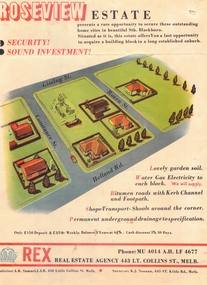
Document, Roseview Estate, 1959
... Whitehorse Historical Society Inc. 2-10 Deep Creek Road ...Brochure for auction of 59 lots in 'Roseview Estate'Brochure for auction of 59 lots in 'Roseview Estate', Blackburn South, 14 March 1959. Agent : Rex Real Estate Agency.Brochure for auction of 59 lots in 'Roseview Estate'auctions, roseview estate, blackburn south, holland road, gissing street, rosen street, constance street, rex real estate agency -
Whitehorse Historical Society Inc.
Article, People before profit - land sale opponent, 1992
... Livingstone Road Vermont South Vermont South A community group has ...A community group has criticised Nunawading Council's move to rezone and sell the Vermont South site it uses.A community group has criticised Nunawading Council's move to rezone and sell the Vermont South site it uses. The land is on the corner of Burwood Highway and Livingstone Road which is zoned D 'Public Open Space'. Council has deferred the decision to rezone until after a public meeting.A community group has criticised Nunawading Council's move to rezone and sell the Vermont South site it uses.town planning, city of nunawading, burwood highway, vermont south, livingstone road, vermont south, vermont south -
Whitehorse Historical Society Inc.
Article, Land sale to proceed, 1992
... Vermont South Livingstone Road Vermont South Vermont South Council ...Council voted to rezone and sell land they own on corner of Burwood Highway and Livingstone Road. Claims that the community is losing open space are not valid.Council voted to rezone and sell land they own on corner of Burwood Highway and Livingstone Road. Claims that the community is losing open space are not valid.Council voted to rezone and sell land they own on corner of Burwood Highway and Livingstone Road. Claims that the community is losing open space are not valid.town planning, city of nunawading, burwood highway, vermont south, livingstone road, vermont south, vermont south -
Whitehorse Historical Society Inc.
Newspaper - Article, Mixed life in mixed business, 18/01/1990
... Mitcham melbourne Pooley Beatrice Blackburn South Canterbury Road ...Article by Judith Kerr on Beatrice Pooley, her autobiography, 'Mardie' and her life as a shopkeeper in Blackburn South.pooley, beatrice, blackburn south, canterbury road, blackburn south -
 Whitehorse Historical Society Inc.
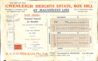
Document, Gwenleigh Heights Estate, Box Hill, unknown
... south canterbury road agnew street aberdeen road h. v. palmer ...Land plan of 67 allotments for sale between Canterbury Road, Middleborough Road and Agnew Street, Box Hill. (Now Blackburn South)land subdivision, middleborough road, blackburn south, canterbury road, agnew street, aberdeen road, h. v. palmer (estate agent) -
 Whitehorse Historical Society Inc.
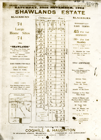
Document, Shawlands Estate, 22/11/1924 12:00:00 AM
... Mitcham melbourne land subdivision canterbury road blackburn south ...Notice of Sale of land Holland Road and Canterbury RoadNotice of Sale of land Holland Road and Canterbury Road Blackburn Original in Haughton Maps LaTrobe LibraryNotice of Sale of land Holland Road and Canterbury Road land subdivision, canterbury road, blackburn south, holland road, shawlands avenue, coghill & haughton, shawlands estate, haughton map collection, state library of victoria. latrobe library -
Whitehorse Historical Society Inc.
Document, Enrolment records, 1967 - 1993
... south canterbury road raleigh street no 29. Enrolments records ...Enrolments records for Holbury Pre-School Centre, 1967 - 1993. Includes names and addresses of all student, also parents' names and father's occupation until 1974.Enrolments records for Holbury Pre-School Centre, 1967 - 1993. Includes names and addresses of all student, also parents' names and father's occupation until 1974. Located Cr Holland and Canterbury Roads until 1970, then in Raleigh Street, Blackburn South.Enrolments records for Holbury Pre-School Centre, 1967 - 1993. Includes names and addresses of all student, also parents' names and father's occupation until 1974.holbury pre-school centre, holland road, blackburn south, canterbury road, raleigh street, no 29. -
Whitehorse Historical Society Inc.
Article, Historic building reduced to rubble, 1988
... it was a fire hazard. Burwood Highway Vermont South Springvale Road ...An old homestead which belonged to the Mullens family for 5 generations.An old homestead which belonged to the Mullens family for 5 generations has been demolished by the Board of Works who now own the land. the Board demolished the house because it was a fire hazard.An old homestead which belonged to the Mullens family for 5 generations.burwood highway, vermont south, springvale road, vermont south, mullens, hugh, mullens, mary, mullens, elma, ellerton, andrew, tate, sherryn, melbourne and metropolitan board of works -
 Whitehorse Historical Society Inc.
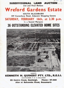
Document, Wreford Gardens Estate, 1/02/1963 12:00:00 AM
... south abercromby road edinburgh road baird court barrina street ...Wreford Gardens Estate,Pamphlet advertising land for sale on Wreford Gardens Estate, Blackburn 16th February, 1963Wreford Gardens Estate,land sales, wreford gardens estate, blackburn south, abercromby road, edinburgh road, baird court, barrina street -
Whitehorse Historical Society Inc.
Article, Speed down to 60, 2014
... Three kms of Blackburn Road in Blackburn South and 1.3 km... Mitcham melbourne VicRoads Blackburn Road Blackburn South Boronia ...Three kms of Blackburn Road in Blackburn South and 1.3 km in Boronia Road to be reduced from 70 km/h to 60 km/hThree kms of Blackburn Road in Blackburn South and 1.3 km in Boronia Road to be reduced from 70 km/h to 60 km/hThree kms of Blackburn Road in Blackburn South and 1.3 km in Boronia Road to be reduced from 70 km/h to 60 km/hvicroads, blackburn road, blackburn south, boronia road, vermont -
Whitehorse Historical Society Inc.
Document, Livermore's property, n.d
... Street Vermont South Morack Road Vermont South Hand drawn map ...Hand drawn map of original Livermore home, Verona Street, Morack Road. See Photograph album.livermore family, city of nunawading, verona street, vermont south, morack road, vermont south -
 Whitehorse Historical Society Inc.
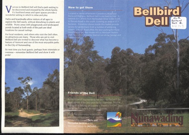
Pamphlet, Bellbird Dell, n.d
... road vermont south george road philip street vermont bellbird ...History and development of Bellbird Dell. Includes colour photos and map.parks and reserves, city of nunawading, morack road, vermont south, george road, philip street, vermont, bellbird dell -
Box Hill Historical Society
Photograph - Wattle Park Chapel
... Elgar Road, Box Hill South, Victoria, Australia... Hill South Elgar Road Milton Crescent Photograph Wattle Park ...View of the Wattle Park Chapel on the corner of Elgar Road and Milton Crescent, Box Hill Southchurches, wattle park chapel, box hill south, elgar road, milton crescent