Showing 1378 items
matching state library victoria
-
 Ballarat Tramway Museum
Photograph - Black & White Photograph/s, John Henry Harvey, c1890
... Black and white print from the State Library of Victoria... Reserved - Copied by State Library of Victoria".... by State Library of Victoria". Black and white print from the State ...Black and white print from the State Library of Victoria, of a horse tram (possibly No. 10), turning left from Sturt St. into Armstrong St. enroute for Skipton St. Has City of Ballaarat Town Hall in the background with two other horse drawn cabs in the view. Has the statue of ???? on the left hand side of the photograph. State Library Multimedia Source Catalogue gives the photographer as John Henry Harvey and date of print as 1875c. Actual date is post 1888. State Library Permission required to reproduce the photo.On rear in pencil in bottom left hand corner "Copy of H92 150/408" and in centre along bottom edge "Reproduction Rights Reserved - Copied by State Library of Victoria".trams, tramways, sturt st, armstrong st, horse trams, ballarat town hall, tram 10 -
 Port Melbourne Historical & Preservation Society
Plan - MMBW, Melbourne and Metropolitan Board of Works (MMBW), 1894 - 1895
... Located on State Library Victoria (SLV) website by member... on State Library Victoria (SLV) website by member Ray Jelley ...Located on State Library Victoria (SLV) website by member Ray JelleyMelbourne Metropolitan Board of Works (MMBW) waste water (sewer) plans from 1894-95. Plan numbers 322, 331, 335, 564, 565, 575. Area bounded by Liardet St, East Esplanade, Foote St, Johns(t)on St and Hobsons Bay. Includes Gas works and Distillery.engineering - board of works, sewerage, mmbw, melbourne and metropolitan board of works -
 Bendigo Historical Society Inc.
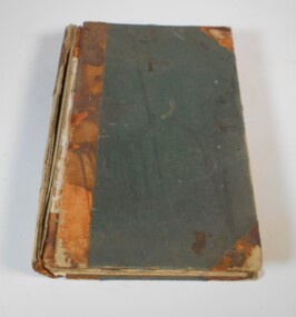
Administrative record - Photographer's record book Vincent Kelly
... is held by State Library Victoria.... Library Victoria. Photographer Vincent Kelly Large book with green ...The Rosenberg Collection of Vincent Kelly Photographs is held by State Library Victoria.Large book with green cover and brown spine. It is a record book of photographer Vincent Kelly, with the headings: Neg. No, Journal, Name and address, size, deposit, date of order, description of order, amount of order, balance due, balance paid, remarks. On the second page there is a receipt glued to the page for a refund and the receipt has the name Kelly printed on it. The book covers the years from 1952 to 1957. photographer, vincent kelly -
Port Melbourne Historical & Preservation Society
Print - Sandridge Foreshore, H Gritten, c. 1865
... in the La Trobe Collection, State Library of Victoria of the 1865... in the La Trobe Collection, State Library of Victoria of the 1865 ...Black and white lasercopy from the watercolour drawing in the La Trobe Collection, State Library of Victoria of the 1865 watercolour of the Sandridge foreshorebuilt environment -
Tatura Irrigation & Wartime Camps Museum
Book, Bendigo, The German Chapter, 1998
... . Back cover, Frnk Cusack. From State Library of Victoria... State Library of Victoria Bendigo, The German Chapter. Book Book ...Written to illustrate German participation in development of bendigo with emphasis on mining industryFront cover black, red printing, picture of Geman miners. Back cover, Frnk Cusack. From State Library of Victoriabooks, history, local, bendigo, german's in bendigo -
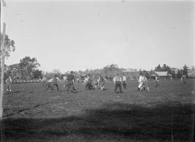 Bacchus Marsh & District Historical Society
Photograph, Football Match at Maddingley Park Bacchus Marsh 1900s
... glass negative held by the State Library of Victoria titled... a digitized glass negative held by the State Library of Victoria ...This photo is a very early example of an action image from an Australian Rules football match in a rural area in Victoria. The identity of the two teams is not confirmed. The team with the dark colored uniform is probably the Bacchus Marsh football team. The other team is possibly Parwan. The style of uniforms suggest the date of the photo is from around 1910 or possibly a few years earlier. This item has particular historic and social significance as an action image of two of the early sporting teams of Bacchus Marsh and district. These type of images are very rare for teams outside of the major metropolitan competitions such as the Victorian Football League of Victorian Football Association. It therefore provides a rare and fascinating depiction of an early football game as it was played and the ground conditions in which footballers played in the early 1900s.A black and white photograph produced from a digitized glass negative held by the State Library of Victoria titled, ‘Men and boys playing football on an oval set among trees and fields’ ca. 1910, Pictures Collection, State Library Victoria, H92.433/20. The description for the image held by the State Library of Victoria does not identify the location where the image was taken. By close comparison with other images of Maddingley Park held by the Bacchus Marsh and District Historical Society the location has been identified as Maddingley Park, Bacchus Marsh. A significant identifier for this image is the presence of the Evans Pavilion in the background which was built in 1896. Trees and statues in the background on the left side of the image also match other images of Maddingley Park from this time.australian rules football, bacchus marsh football club, australian rules football action images -
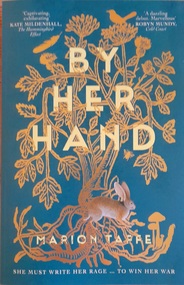
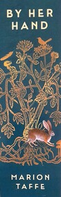 Hymettus Cottage & Garden Ballarat
Work on paper - Bookmark, By Her Hand
... debut novel at Readings store State Library Victoria 12th March... debut novel at Readings store State Library Victoria 12th March ...This bookmark was produced for the launch of the author's debut novel at Readings store State Library Victoria 12th March 2025.Green card with title of book and Author's name to front with gold blocked symbols significant in the novel and quote from text of book on verso with [4th] indicating a Harper Collins 4th Dimension publication.Nilbookmark, debut novel, marion taffe -
 Robin Boyd Foundation
Book, Robin Boyd, Australia's Home, 1952
... State Lending Library of Victoria/withdrawn... Australian history Walsh St library State Lending Library of Victoria ...Australia's Home' was first published in 1952. In this book, Boyd crystallised his ideas on what he saw as the historical development of the everyday suburban home. Accompanying the text was a series of drawings of houses by Boyd that documented his ‘Major Steps of Stylism’.HardcoverState Lending Library of Victoria/withdrawnaustralian architecture, australian history, walsh st library -
Federation University Historical Collection
Image, Robert Malachy Serjeant
... the State Library of Victoria. ... from the State Library of Victoria. Robert Malachy Serjeant ...ROBERT MALACHY SERJEANT (1828-1902) Robert Malachy Serjeant was born on 21 December 1828 at Callington, Cornwall. He was the son of Philip Davey Serjeant, a surgeon in the Royal Marines, and Eliza Malachy. Philip Serjeant died in 1834. His mother, Eliza, remarried John Burgh in 1836. He died in 1837. In September 1848 Eliza, Robert and his two sisters, Caroline and Susan, departed Plymouth on the William Moneya for Port Adelaide and arrived in January 1849. Once gold was discovered in Victoria, Serjeant made his way to Forest Creek (near Castlemaine) and he and his mate Mr Victor, were the first party to sink through the basalt in search of a deep lead. In 1854 he moved to Ballarat to work as a miner and enjoyed some success. In 1855 he was with a group that discovered a 500 ounce nugget. With his share of the sale he set himself up with the latest mining equipment, as well as beginning a lifelong interest in the share market. He became the Manager of the Chryseis, Isis and Garibaldi claims and then the Manager of the Band and Albion Consol Company. He held the position for thirty years and only resigned when the company amalgamated with the Sir Henry Loch Mine. Robert Malachy Serjeant became interested in Politics. The first election for Parliament Representatives for Ballarat was in 1855. Robert stood for election for the first time in 1859, representing Ballarat West. He was also elected to represent Ballarat West in 1874 and 1880. Robert Serjeant’s community involvement extended to Education. Years of discussion eventually saw the development of the Ballarat School of Mines, the first school of mines in Australia. The inaugural School Council was formed in 1870 with Sir Redmond Barry, the Chief Justice, as President and Robert Malachy Serjeant as a member of the council. He held a position on the council until illness forced him to retire in 1889. He was elected a Life Governor in 1889. He was also a Life Governor of the Ballarat Hospital. Robert Serjeant showed Prince Albert and Prince George (later King George V) around the Band and Albion Mine. At the age of 42, Robert enrolled as a student at the School of Mines in 1871. He obtained a Certificate of Competency in Assaying (including Metallurgy) in 1875. The first certificate in “Geology as Applied to Mining” was awarded to Robert Serjeant in 1876. Robert Serjeant was an active and generous supporter of the School of Mines. As well as being a financial contributor, he lectured and examined in the Principles and Practice of Mining. He was regarded as an authority on alluvial and quartz mining and was a member of the Ballarat Local Court and mining board. In 1977 Robert, Joseph Flude and Henry Caselli donated the patent rights of a novel Pyrites furnace to the school. The R.M. Serjeant Scholarship at the Ballarat School of Mines resulted after a reward was offered for the first to produce the best method of treating auriferous ores – other than the smelting method. The offer was open for two years but not awarded. The money for this was donated by Robert Serjeant to the amount of 256 Pounds. It was then used to fund the School of Mines Scholarship in Engineering (1889). It was first awarded in 1922. Robert Malachy Serjeant died on 25 October 1902 and was buried at the Ballaarat Old Cemetery. (Sometimes Malachy is incorrectly written as Malachi)Two photographic portraits of mine manager Robert Malachy Serjeant. Both portraits were purchased by the donor from the State Library of Victoria. robert malachy serjeant, r.m. sergeant, robert malachi serjeant, band of hope and albion consols -
Federation University Historical Collection
Photographs - Black and White, Private Residence of Townsend MacDermott, 1861
... the State Library of Victoria c1980. It shows a bluestone house... and white photograph purchased from the State Library of Victoria ...The residence was designed by architect Henry Richards Caselli.Copy of a black and white photograph purchased from the State Library of Victoria c1980. It shows a bluestone house with a number of women and girls on the verandah. townsend macdermott, henry richards caselli, bluestone house -
 Lakes Entrance Historical Society
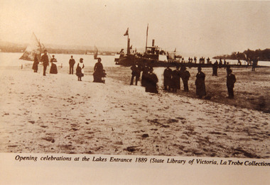
Photograph - Opening Entrance, Eastwood Bros, 1889c
... Library of Victoria, LaTrobe Collection)... Library of Victoria, LaTrobe Collection) Sepia photograph showing ...Two other copies in good order - b & w 14 x 20 cm, black and white 20 x 25.5 cm both have tear marksSepia photograph showing steamers at wharf near newly opened Entrance. People on steamers and wharf and on beach. Town on left background hummocks on right background. Steamer on end of wharf is PS Nell, other steamer SS Dargo?. Two small sailing boats on lake. Lakes Entrance VictoriaOpening celebrations at the Lakes Entrance 1889 (State Library of Victoria, LaTrobe Collection) waterfront, people, celebration -
 Buninyong & District Historical Society
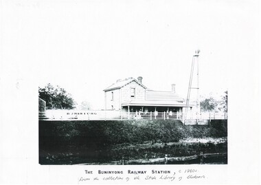
Print - Black and white copy of Yendon (Buninyong) Station c1860s, The Buninyong Railway Station
... of the State Library of Victoria... the collection of the State Library of Victoria A black and white copy ...Yendon Railway Station, built 1862 as Buninyong (East) Station. Yendon No.1 and No. 2 Roads constructed to connect cab service with the township of Buninyong. The station name was changed to Yendon 1878.This image illustrates The Buninyong Railway Station in the 1860's on the Ballarat to Geelong line, its name was changed to Yendon Railway Station in 1878 and was demolished in 1969A black and white copy of a photograph of Buninyong (Yendon) Railway Station in the 1860sThe Buninyong Railway Station, c 1860s from the collection of the State Library of Victoriabuninyong railway station, yendon (buninyong east) railway station -
 Kew Historical Society Inc
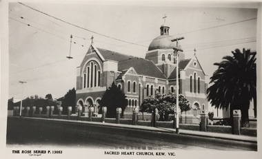
Print, Rose Stereograph Company, Sacred Heart Church, Kew, Vic, Twentieth Century
... print of a Rose Stereograph Co. postcard in the State Library... Co. postcard in the State Library of Victoria collection ...The history of the church goes back to 1872 when Jesuits purchased land in Walpole Street. By 1875 Archbishop Gould had laid a foundation stone on 14 February for a school. Early services for local Catholics were held in Richmond, Collingwood and later Hawthorn. By 1899 the land for the current church was purchased after a donation by Mr James Crotty of 3,000.00. The foundation stone was laid on 15 December 1918 by Archbishop Mannix. The dimensions of the church were to be 139 feet long by 77 feet wide with seating for 850 people. The cost of construction was 15,000.00. (Source: www.churchhistories.net.au )Sacred Heart Church, Kew, Vic., circa 1920-54. Photographic print of a Rose Stereograph Co. postcard in the State Library of Victoria collection.Inscription: The Rose Series P. 13053, Sacred Heart Church, Kew, Vic." Annotation in pencil: "KH-5. Foundation Stone laid 1918, completed 1921."churches -- kew (vic.), sacred heart church -- cotham road -- kew (vic.), catholic churches -- melbourne (vic.) -
 Mission to Seafarers Victoria
Plan - Architectural Plan, copy, Walter Butler, c. 2013
... Street, held at the State Library of Victoria.... at the State Library of Victoria. Plan Architectural Plan, copy Walter ...The copy was part of the conservation plan written by Peter Doig Architecture. Doig Architecture joined Baldasso Cortese in 2019.Large copy in black and white on glossy strong paper of the original bButler plan for the first central mission, Siddeley Street, held at the State Library of Victoria.peter doig, redevelopment, built heritage, walter richmond butler (1864–1949), siddeley street institute -
Port Melbourne Historical & Preservation Society
Print - Sandridge Foreshore, H Gritten, c. 1865
... Library of Victoria, by permission of the Library Council... Library of Victoria, by permission of the Library Council ...Sandridge Foreshore - 1975 National Bank reproduction of 1865 watercolour drawing in the La Trobe Collection, State Library of Victoria, by permission of the Library Council of Victoria.built environment -
 Kew Historical Society Inc
Photograph, The Rowan Car, 1893
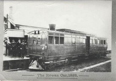
... an original in the La Trobe Library (State Library of Victoria... an original in the La Trobe Library (State Library of Victoria ...This work forms part of the collection assembled by the historian Dorothy Rogers, that was donated to the Kew Historical Society by her son John Rogers in 2015. The manuscripts, photographs, maps, and documents were sourced by her from both family and local collections or produced as references for her print publications. Many were directly used by Rogers in writing ‘Lovely Old Homes of Kew’ (1961) and 'A History of Kew' (1973), or the numerous articles on local history that she produced for suburban newspapers. Most of the photographs in the collection include detailed annotations in her hand.The Rogers Collection provides a comprehensive insight into the working habits of a historian in the 1960s and 1970s. Together it forms the largest privately-donated collection within the archives of the Kew Historical Society.A print made by/for Dorothy Rogers in the 1960s from an original in the La Trobe Library (State Library of Victoria) showing one of the trains on the Outer Circle Railway."Train used on Outer Circle Railway 1893. Only ones available supplied by La Trobe Library"outer circle railway, rowan car, dorothy rogers -
 Warrnambool and District Historical Society Inc.
Programme - Microfiche, Exhibition of Women's Work, 1907, Circa 2000
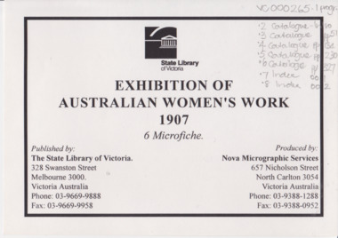
... State Library of Victoria Exhibition os Australian Women’s... 1907 women’s work exhibition State Library of Victoria ...This exhibition was held in October 1907 and ran for 5 weeks. There were over 15000 contributors in the fields of needlework, cookery, Horticulture, fine and applied arts. There was a wide variety of activities, lectures and social events. There were approximately 250,000 people who attended.An important source of work and information relating to a major event in the State of Victoria and in the work of women.Eight sheets of microfilm enclosed in plastic sheet with title page, white with black text.State Library of Victoria Exhibition os Australian Women’s work 1907 6 microfiche. warrnambool, exhibition australian women’s work, 1907 women’s work exhibition -
 Lakes Entrance Historical Society
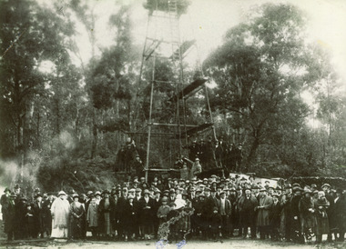
Photograph - Bunga No.1 Oil Bore, 1924
... The First Oil Well Lake Bunga 1924 - State Library... 1924 - State Library of Victoria, LaTrobe Collection Sepia ...First show of oil plus gas and water 25th July 1924.Sepia toned photograph of the crowd of people gathered at the Lake Bunga No. 1 oil Bore to observe the spudding-in ceremony. Lakes Entrance VictoriaThe First Oil Well Lake Bunga 1924 - State Library of Victoria, LaTrobe Collectionhistoric site, oil and gas industry -
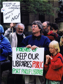 St Kilda Historical Society
Photograph, 1996
... ) outside the State Library of Victoria about the contracting out.... Demonstration at State Library of Victoria by Friends of Port Phillip... Phillip Libraries (FOPPL) outside the State Library of Victoria ...Protest by the Friends of Port Phillip Libraries (FOPPL) outside the State Library of Victoria about the contracting out of Port Phillip Library Services in 1996. According to the FOPPL, this was the only documented case of privatisation of a public library service in Australia. Archives of the campaign: St Kilda Historical Society.Colour photographL to R Colin S Watson, Hans Lofgren, Kai Lofgren. Demonstration at State Library of Victoria by Friends of Port Phillip Libraries, 1996, opposing contracting out of the library service, City of Port Phillip. Only documented case of privatisation of a public library service in Australia. Archives of the campaign: St Kilda Historical Society.st kilda, port phillip, port phillip library, port phillip library service, 1996 -
Port Melbourne Historical & Preservation Society
Photograph - Town Pier, Sandridge, J W Lindt, 1870s
... COPYRIGHT State Library Victoria (image b46977) Town Pier... COPYRIGHT State Library Victoria (image b46977) Town Pier ...COPYRIGHT State Library Victoria (image b46977) Town Pier, Sandridge approx 1876-1894. A competitor to Railway Pier but without the rail facility. In the 20th Century it became limited to timber or collier ships. Pier demolished in 1950s. This image shows horse-drawn wagons being loaded and many sailing ships docked in the background. Image used in PMHPS calendar 2015 (July)piers and wharves - town pier, transport - horse, transport - shipping -
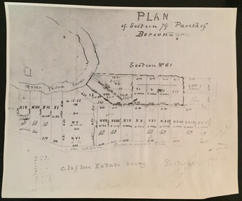 Kew Historical Society Inc
Print - Subdivision Plan (copy), Plan of Section 79 Parish of Boroondara (Clifton Estate), Nineteenth Century
... Collection of the State Library of Victoria. The numbered lots... reproduction of a plan in the Vale Collection of the State Library ...This work forms part of the collection assembled by the historian Dorothy Rogers, that was donated to the Kew Historical Society by her son John Rogers in 2015. The manuscripts, photographs, maps, and documents were sourced by her from both family and local collections or produced as references for her print publications. Many were directly used by Rogers in writing ‘Lovely Old Homes of Kew’ (1961) and 'A History of Kew' (1973), or the numerous articles on local history that she produced for suburban newspapers. Most of the photographs in the collection include detailed annotations in her hand. The Rogers Collection provides a comprehensive insight into the working habits of a historian in the 1960s and 1970s. Together it forms the largest privately-donated collection within the archives of the Kew Historical Society.A photographic reproduction of a plan in the Vale Collection of the State Library of Victoria. The numbered lots represent the first land sales in Kew in the area north of Studley Park Road.maps (kew), plan of section 79 parish of boroondara -
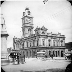
 Ballarat Tramway Museum
Photograph - Black & White Photograph/s, Charles Rudd, c1890
... Black and white print from the State Library of Victoria... Reserved - Copied by State Library of Victoria".... by State Library of Victoria". Black and white print from the State ...Black and white print from the State Library of Victoria, June 1999 of a horse tram crossing the intersection of Sturt and Lydiard Street Ballarat c1890. Tram is travelling east to Grenville St. on the south side of Sturt St. (wrong side these days). Has the Ballarat Post Office building in the background with buildings on the north east side of Sturt St. as well. Has a number of horse drawn cabs in photo and women in white clothing holding umbrellas over their head indicating a hot day. In the right hand side of the photo is the statue of poet Robert Burns. Has number "530" in the bottom left hand corner of photograph. State Library Multimedia Source Catalogue gives the photographer as Charles Rudd, 1849 to 1901, date of photo 1889-1891. Copy made Oct. 2001 for the "gold, Gold GOLD" temporary exhibition - colour laser print onto card, with Velcro dots on rear. Stored in box D1 (Display Box) 02/2003. State Library Permission required to reproduce the photo.On rear in pencil in bottom left hand corner "Copy of H39358/10" and in centre along bottom edge "Reproduction Rights Reserved - Copied by State Library of Victoria".trams, tramways, sturt st, lydiard st, horse trams, post office, two way traffic -
Healesville Sanctuary Heritage Centre
Newspaper - Newspaper Cutting, Report, The Argus, Melbourne, Changes Planned for Sanctuary, 18 May 1948
... State Library Melbourne Victoria...State Library Melbourne Victoria 1940s Recommendations from ...Recommendations from report by Mr Crosbie Morrison are being considered by State GovernmentphotocopyRecommendations from report by Mr Crosbie Morrison are being considered by State Government 1940s -
 Hymettus Cottage & Garden Ballarat
Work on paper - Book, By Her Hand
... Library Victoria on 12th March 2025. Hymettus Cottage was home... Library Victoria on 12th March 2025. Hymettus Cottage was home ...Set in tenth century England in the time of Aethelflaed of Mercia and the consolidation of Mercia, Wessex and other regions prior to the rise of Edward 1st. The work relates the story of a girl who is subjected to a hard father and suffers from the devastation of Viking raids before advancing through her maturity and independence from male domination.See image.fictionSet in tenth century England in the time of Aethelflaed of Mercia and the consolidation of Mercia, Wessex and other regions prior to the rise of Edward 1st. The work relates the story of a girl who is subjected to a hard father and suffers from the devastation of Viking raids before advancing through her maturity and independence from male domination. mercia, wessex, england, aethelflaed, the peak district -
 Federation University Historical Collection
Photograph - print, B. Ireland, The Eureka Stockade, c1890 -1900
... Library of Victoria catalogue the work is an over-painted.... The original is in the collection of the State Library of Victoria.... The original is in the collection of the State Library of Victoria ...This image was taken for the purposes of illustrating Jack Harvey's book 'Eureka rediscovered'. According to the State Library of Victoria catalogue the work is an over-painted photographic print, photographed by an unknown photographer from the painted canvas by Izett Watson and Thaddeus Welch, which was exhibited as a painted cyclorama in the 'Battle of Waterloo' Cyclorama building, Fitzroy, ca. 1891. This is based on the evidence that the pulleys and brick wall are discernible at the top edge of the image which B. Ireland has not over-painted. This artist may by Beryl Ireland, who was a miniaturist and studied at the National Gallery of Victoria Art School in the 1870s. Beryl Ireland was the niece of Richard Davies Ireland (1816-1877), the lawyer for the Eureka defendants in 1855. Information provided by Dr. Mimi Colligan, 2002. (http://search.slv.vic.gov.au/primo_library/libweb/action/display.do?tabs=detailsTab&ct=display&fn=search&doc=SLV_VOYAGER1657187&indx=2&recIds=SLV_VOYAGER1657187&recIdxs=1&elementId=1&renderMode=poppedOut&displayMode=full&frbrVersion=&dscnt=3&frbg=&tab=default_tab&dstmp=1339483021572&srt=rank&mode=Basic&dum=true&fromLogin=true&vl(freeText0)=Eureka%20Stockade%20Ireland&vid=MAIN)Large format reproduction of a handcoloured photograph of the Eureka Stockade taken from the painted canvas by Izett Watson and Thaddeus Welch, which was exhibited as a painted cyclorama in the 'Battle of Waterloo' Cyclorama building, Fitzroy, c1891. The original is in the collection of the State Library of Victoria. (http://handle.slv.vic.gov.au/10381/132726) Signed lower right "B. Ireland"eureka stockade, ireland, b. ireland, beryl ireland -
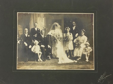 Kew Historical Society Inc
Photograph, Wedding Party, Nineteenth Century
... Melbourne. The State Library of Victoria records that he was 'active.... The State Library of Victoria records that he was 'active' between ...One of three historically interesting photographs, without provenanceGroup portrait at an unidentified wedding. The photographers name is included on the mount: A.H. Williams, South Melbourne. The State Library of Victoria records that he was 'active' between 1899-1935.Photographer: "A.H. Williams, South Melbourne"wedding photographs -
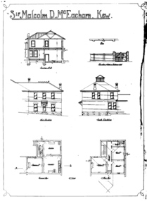 Kew Historical Society Inc
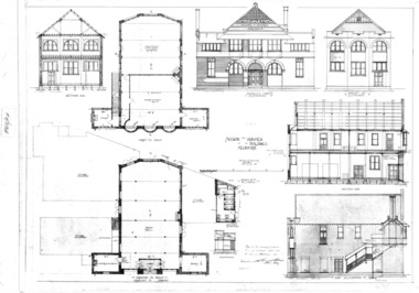
Drawing - Architectural Drawings [copy], William Pitt, Sir Malcolm D. McEacharn, Kew, 1901
... Library of Victoria.... of the State Library of Victoria. Sir Malcolm D. McEacharn, Kew Drawing ...A set of architectural drawings of additions to Goathland (originally Byram, and later Goathland and Lowan). The drawings, by the architect William Pitt represent additions to the size of Goathland. Pitt had previously worked with the original architect of the house, Edward George Kilburn, of Ellerker & Kilburn, who had designed Byram for the industrialist George Ramsden in 1888. 'Lost Glories: a memorial to forgotten Australian buildings' was published by David Latta in 1986. It tells the story of a number of significant Australian buildings that had previously been demolished. A chapter in the book was devoted to Goathland, later known as Tara Hall. To supplement the text, he sourced photographs from a range of suppliers, chiefly the Royal Women's Hospital which had once owned Tara Hall, but had sold it in 1960. This is one of the photographs donated to KHS by the author.Six black and white architectural drawings by the architect William Pitt for additions to the home of Sir Malcolm McEacharn in Studley Park Road. The original is in the collection of the State Library of Victoria."Sir Malcolm D. McEacharn, Kew"william pitt, malcolm mceacharn, architects -- melbourne (vic.) -- william pitt, architectural drawings, byram, tara hall, goathland -
Moorabbin Air Museum
Manual (item), Ralph D. Bent et al, Aircraft Maintenance and Repair Revised Edition, 1955
... Owned by the State Library of Victoria in the past.... Moorabbin melbourne Owned by the State Library of Victoria ...Owned by the State Library of Victoria in the past. -
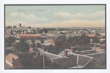 Rutherglen Historical Society
Image, Bird's-eye View of Rutherglen
... Library of Victoria, showing a view of Rutherglen. A copy... the State Library of Victoria, showing a view of Rutherglen. A copy ...Original postcard was produced c1906. This print was made in 2017.A colour print of a postcard, downloaded from the State Library of Victoria, showing a view of Rutherglen. A copy of the State Library's record for the original has been printed and pasted to the back of this print. rutherglen -
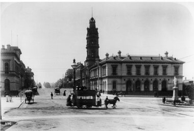
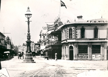 Federation University Historical Collection
Photograph - Black and White, Bridge Street Ballarat , c1890, c1890
... The original of this image is held by the State Library... The original of this image is held by the State Library of Victoria ...The original of this image is held by the State Library of Victoria.Copy of a black and white photograph of Bridge Street Ballarat from the corner of Grenville Street and Sturt Street. The photo shows a street lamp in the middle of the intersection, fire hydrant, Yeoman's flag, tram tracks, and horse drawn vehicles.bridge street ballarat, sturt street ballarat, grenville street ballarat,, f.b. wilson, buck's head hotel