Showing 285062 items
matching streets,roads,melbourne,map,melway
-
 Victorian Railway History Library
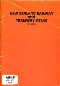
Book, Quail Map Company, New Zealand Railway & Tramway Atlas, 1985
Railway and tramway maps of New Zealand in 1965.Index, maps, p.46.non-fictionRailway and tramway maps of New Zealand in 1965.railway and tramway maps - new zealand, railways and tramways - new zealand - history -
 Victorian Railway History Library
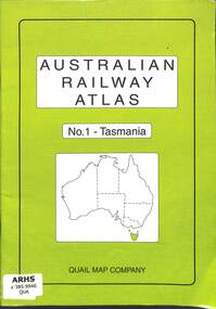
Book, Quail Map Company, Australian Railway Atlas No.1 - Tasmania, 2004
Railway and tramway maps of Tasmania both government and private railwaysindex, maps, p.33.non-fictionRailway and tramway maps of Tasmania both government and private railwaysrailway and tramway maps - tasmania, railway operations - tasmania - history -
 Victorian Railway History Library
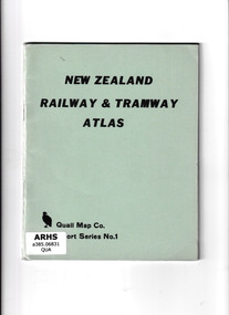
Book, Quail Map Company, New Zealand Railway and Tramway Atlas, 1965
Railway and tramway maps of New Zealand in 1965.Index, maps, p.37.non-fictionRailway and tramway maps of New Zealand in 1965.railway and tramway maps - new zealand, railways and tramways - new zealand - history -
 Bendigo Military Museum
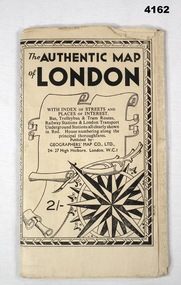
Map - MAP of LONDON, The Authentic Map of London
Map of London with also places of interest. Part of th collection of Frederick Gardner Davey DFC No 410533 RAAF. Refer cCat No 3536P for his service details.Black and white folded street map with transport routes/stations marked in orange. Cover is black and white print, features a scroll and compass design inside a B & W border, written details in black type, street index printed on inside of the cover.map, london -
 Greensborough Historical Society
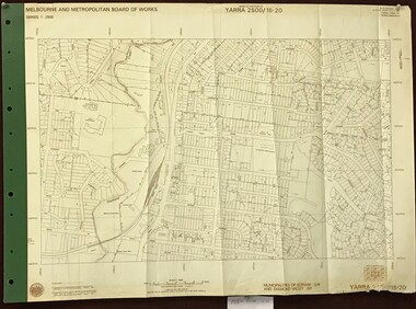
Map, Melbourne and Metropolitan Board of Works. Survey Division, MMBW, Yarra 2500 / 13.23. Plenty, Middle Gorge, 1978_04
Melbourne and Metropolitan Board of Works. Yarra 2500 [base map] 13-23. Plenty / Middle Gorge. Parish of Morang 3183. Municipalities of Diamond Valley 257 and Whittlesea 239. Prominent streets include: Gorge Road, Kurrak Road and Browns Lane. Features include the Plenty River and Plenty Gorge Park.MMBW Map in 1:2500 [scale] series. Cream parchment with green tape reinforcing on edges and punched holes on left edge.mmbw, melbourne and metropolitan board of works, shire of diamond valley, plenty - maps, plenty gorge park -
 Whitehorse Historical Society Inc.
Map, Blackburn and Nunawading Map, 1960's?
Map of Blackburn and Nunawading.Map of Blackburn and Nunawading.Map of Blackburn and Nunawading.maps, blackburn, nunawading -
Port Melbourne Historical & Preservation Society
Pamphlet, Port Melbourne City Library, Some information about the history of Port Melbourne, Jun 1985
June KIRBY - History Librarian, Wendy MORRIS - Chief LibrarianBinder containing various information about the history of Port Melbourne. Produced by Port Melbourne Libraryport melbourne library, local government - city of port melbourne, june kirby, wendy morris -
 Greensborough Historical Society
Map, Melbourne and Metropolitan Board of Works. Survey Division, MMBW, Yarra 2500 / 14.22. St Helena, St Katherine's Church, 1979_08
Melbourne and Metropolitan Board of Works. Yarra 2500 [base map] 14.22. St Helena, St Katherine's Church. Parish of Nillumbik 3310. Municipality of Diamond Valley 257. Prominent streets St Helena Road, Weidlich Road, Yan Yean Road and Allumba Drive. Features include St Katherine's Church of England and the St Helena Secondary College site.MMBW Map in 1:2500 [scale] series. Cream parchment with green tape reinforcing on edges and punched holes on left edge.mmbw, melbourne and metropolitan board of works, shire of diamond valley, st helena - maps, st katherines church st helena -
 Kew Historical Society Inc
Plan, Melbourne & Metropolitan Board of Works : Borough of Kew : Detail Plan No.1570, 1905
The Melbourne and Metropolitan Board of Works (MMBW) plans were produced from the 1890s to the 1950s. They were crucial to the design and development of Melbourne's sewerage and drainage system. The plans, at a scale of 40 feet to 1 inch (1:480), provide a detailed historical record of Melbourne streetscapes and environmental features. Each plan covers one or two street blocks (roughly six streets), showing details of buildings, including garden layouts and ownership boundaries, and features such as laneways, drains, bridges, parks, municipal boundaries and other prominent landmarks as they existed at the time each plan was produced. (Source: State Library of Victoria)This plan forms part of a large group of MMBW plans and maps that was donated to the Society by the Mr Poulter, City Engineer of the City of Kew in 1989. Within this collection, thirty-five hand-coloured plans, backed with linen, are of statewide significance as they include annotations that provide details of construction materials used in buildings in the first decade of the 20th century as well as additional information about land ownership and usage. The copies in the Public Record Office Victoria and the State Library of Victoria are monochrome versions which do not denote building materials so that the maps in this collection are invaluable and unique tools for researchers and heritage consultants. A number of the plans are not held in the collection of the State Library of Victoria so they have the additional attribute of rarity.Original survey plan, issued by the MMBW to a contractor with responsibility for constructing sewers in the area identified on the plan within the Borough of Kew. The plan was at some stage hand-coloured, possibly by the contractor, but more likely by officers working in the Engineering Department of the Borough and later Town, then City of Kew. The hand-coloured sections of buildings on the plan were used to denote masonry or brick constructions (pink), weatherboard constructions (yellow), and public buildings (grey). Plan No.1570 shows the layout of gardens and houses in Sackville Street, Davis Street, Wrixon Street, and Fitzwilliam Street in 1904. While Thomas Street is included on the map, at this stage no houses had been built. The plan identifies two named houses: ‘Fairview’ and ‘Kylemore’. Fairview is more fully delineated in Plan No.1563. Kylemore is one of the few houses in Kew designed by John Beswicke. The most notable owner of Kylemore was William Whitehead, who owned the house between 1895 and 1900. In 1894, Australian newspapers reported the marriage of Whitehead’s daughter to Dr. Gerald Eugene Cussen, the brother of Sir Leo Cussen, the Supreme Court Judge. The married couple was to live at ‘Wilton’ (now the Kew RSL) from 1911-15.melbourne and metropolitan board of works, detail plans, mmbw 1570, cartography -
Whitehorse Historical Society Inc.
Map, Map, Parish of Nunawading, 1850's
A basic map of the Parish of Nunawading to which additions have been made. Scale 70 chains:3.5 inchesA basic map of the Parish of Nunawading to which additions have been made. Scale 70 chains:3.5 inchesmaps, parish of nunawading -
 Surrey Hills Historical Society Collection
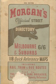
Book, Morgan's Official Street Directory, c1940s
incl.index. This Street Directory of Melbourne and suburbs, c1940s, includes a list of suburbs, their mileage from the city and how to reach them; an index to localities as well as the index to streets appearing on the maps. It also shows bus routes, railways and tramways routes on the maps.incl.index. This Street Directory of Melbourne and suburbs, c1940s, includes a list of suburbs, their mileage from the city and how to reach them; an index to localities as well as the index to streets appearing on the maps. It also shows bus routes, railways and tramways routes on the maps.melbourne metropolitian area, suburbs, cities and towns, maps -
Stawell Historical Society Inc
Map - Electoral Map, Victorian Government, Map of North - Western ( Country) Electoral Province Legislative Council 1939, 1939
Electoral MapMap Overprinted with Provinces In RedScale 8 Miles to 1 Inchgovernment -
 Kew Historical Society Inc
Plan, Melbourne & Metropolitan Board of Works : Borough of Kew : Detail Plan No.1568, 1905
The Melbourne and Metropolitan Board of Works (MMBW) plans were produced from the 1890s to the 1950s. They were crucial to the design and development of Melbourne's sewerage and drainage system. The plans, at a scale of 40 feet to 1 inch (1:480), provide a detailed historical record of Melbourne streetscapes and environmental features. Each plan covers one or two street blocks (roughly six streets), showing details of buildings, including garden layouts and ownership boundaries, and features such as laneways, drains, bridges, parks, municipal boundaries and other prominent landmarks as they existed at the time each plan was produced. (Source: State Library of Victoria)This plan forms part of a large group of MMBW plans and maps that was donated to the Society by the Mr Poulter, City Engineer of the City of Kew in 1989. Within this collection, thirty-five hand-coloured plans, backed with linen, are of statewide significance as they include annotations that provide details of construction materials used in buildings in the first decade of the 20th century as well as additional information about land ownership and usage. The copies in the Public Record Office Victoria and the State Library of Victoria are monochrome versions which do not denote building materials so that the maps in this collection are invaluable and unique tools for researchers and heritage consultants. A number of the plans are not held in the collection of the State Library of Victoria so they have the additional attribute of rarity.Original survey plan, issued by the MMBW to a contractor with responsibility for constructing sewers in the area identified on the plan within the Borough of Kew. The plan was at some stage hand-coloured, possibly by the contractor, but more likely by officers working in the Engineering Department of the Borough and later Town, then City of Kew. The hand-coloured sections of buildings on the plan were used to denote masonry or brick constructions (pink), weatherboard constructions (yellow), and public buildings (grey). Plan No.1568 covers the area bounded by Cotham Road, John Street, Sackville Street, and Edward Street. Alfred Street and Rowland Street are in shown in the middle of the plan. The two most notable buildings shown are ‘St Helliers’, the home of the Dumaresq family, and St Hilary’s Church and school. While the colours used to indicate St Hilary’s are grey as in other civic/public buildings, the first St Hilary’s Anglican Church was at this stage constructed in weatherboard. At the left of the plan, facing Sackville Street is a house named ‘Glencara’. The 1988 ‘Kew Conservation Study’ recorded that “The first documentary evidence of this house comes from Rate Books which record that in 1893 a Mrs Treadway was the owner of this building with an N.A.V. of £81? At that date the occupier of the house was Charles B. Kelly, a clerk, while by 1910 Kelly had become the owner of the property described in that year ‘as a six-roomed stone, brick and wood house with stables and outbuildings’”. Contrary to this description, the 1905 plan indicates that the house was entirely constructed of masonry.melbourne and metropolitan board of works, detail plans, mmbw 1568 -
 Kew Historical Society Inc
Plan, Melbourne & Metropolitan Board of Works : Borough of Kew : Detail Plan No.1302, 1910
The Melbourne and Metropolitan Board of Works (MMBW) plans were produced from the 1890s to the 1950s. They were crucial to the design and development of Melbourne's sewerage and drainage system. The plans, at a scale of 40 feet to 1 inch (1:480), provide a detailed historical record of Melbourne streetscapes and environmental features. Each plan covers one or two street blocks (roughly six streets), showing details of buildings, including garden layouts and ownership boundaries, and features such as laneways, drains, bridges, parks, municipal boundaries and other prominent landmarks as they existed at the time each plan was produced. (Source: State Library of Victoria)This plan forms part of a large group of MMBW plans and maps that was donated to the Society by the Mr Poulter, City Engineer of the City of Kew in 1989. Within this collection, thirty-five hand-coloured plans, backed with linen, are of statewide significance as they include annotations that provide details of construction materials used in buildings in the first decade of the 20th century as well as additional information about land ownership and usage. The copies in the Public Record Office Victoria and the State Library of Victoria are monochrome versions which do not denote building materials so that the maps in this collection are invaluable and unique tools for researchers and heritage consultants. A number of the plans are not held in the collection of the State Library of Victoria so they have the additional attribute of rarity.Original survey plan, issued by the MMBW to a contractor with responsibility for constructing sewers in the area identified on the plan within the Borough of Kew. The plan was at some stage hand-coloured, possibly by the contractor, but more likely by officers working in the Engineering Department of the Borough and later Town, then City of Kew. The hand-coloured sections of buildings on the plan were used to denote masonry or brick constructions (pink), weatherboard constructions (yellow), and public buildings (grey). The absence of buildings and or property in Kew facing the Yarra is the most notable feature of this plan. Walmer Street and its bridge stretched, then and now, from Studley Park Road to Victoria Street, Richmond. On the Richmond side of the Yarra, there was evidence in 1904 of industry (‘Wool shed’; Soap Works’) and entertainment (‘Skittle Alley’). In reality, another Plan (No.1303) shows Chinese Gardens bordering the Yarra on the Kew side and buildings in Young Street.melbourne and metropolitan board of works, detail plans, mmbw 1302, cartography -
 Greensborough Historical Society
Map, Melbourne and Metropolitan Board of Works. Survey Division, MMBW, Yarra 2500 / 15.20. Eltham, 1977_08
Melbourne and Metropolitan Board of Works. Yarra 2500 [base map] 15.20. Eltham. Municipalities of Diamond Valley 257 and Eltham 238. Prominent streets include: Main Road, Henry Street and Livingstone. Features include the Eltham Station, Catholic Ladies' College, Judge Book Memorial Village and Eltham Central Park.MMBW Map in 1:2500 [scale] series. Cream parchment with green tape reinforcing on edges and punched holes on left edge.mmbw, melbourne and metropolitan board of works, shire of diamond valley, nillumbik, eltham - maps -
4th/19th Prince of Wales's Light Horse Regiment Unit History Room
Document, Port Melbourne Municipal Band, 19/9/1958
As it happened, the Port Melbourne Band was recruited into the Regiment.A deputation to the 4th/19th PWLH as called for by the then Commanding Officer, Lt Col B G Hosken, with a view to seek the reaction of the Port Melbourne Municipal Band committee on the suggestion that the band enlist in the Army as a complete unit. Contained in a yellow folder.band, port melbourne -
 Melbourne Tram Museum
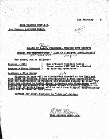
Document - Memorandum, Melbourne & Metropolitan Tramways Board (MMTB), Parade of Royal Personnel through City Streets, 4/02/1946 12:00:00 AM
... Parade of Royal Personnel through City Streets ...Parade of Royal Personnel through City Streets - Friday 18th July 1947. Memo from JM Harry, Dist Traffic Supt SS to Mr Fisher Hawthorn Depot for tram scheduling for above event. Memo originally dated 1946 but altered in pencil to 1947.Dates altered in penciltrams, tramways, events, parades -
 Melbourne Tram Museum
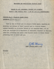
Document - Memorandum, Melbourne & Metropolitan Tramways Board (MMTB), Parade of RN personnel through city streets, 17/01/1946 12:00:00 AM
... Parade of RN personnel through city streets ...Parade of RN personnel through city streets Friday 25th January 1946, 1.20 to 1.55PM Memo from JM Harry, Dist Traffic Supt SS regarding tram arrangements for position no 3 - Franklin St Shunt. Memo dated 17th January 1946.Notations written in pencil on several memos.trams, tramways, events, franklin st, victoria st, swanston st, elizabeth st, bourke st -
 Melbourne Tram Museum
Document - Memorandum, Melbourne & Metropolitan Tramways Board (MMTB), "Arrangements for Air Training Corps Parade through the city streets on Saturday 15th April 1944", Apr. 1944
... city streets on Saturday 15th April 1944" ..."Arrangements for Air Training Corps Parade through the city streets on Saturday 15th April 1944" Letter from HS Wootton, town clerk advising of event. Several memos from JM Harry, Dist Traffic Supt SS regarding tram and bus arrangements.Notations written in pencil on memo.trams, tramways, events, parades -
 Melbourne Tram Museum
Document - Memorandum, Melbourne & Metropolitan Tramways Board (MMTB), "Procession of Combined Women's Services through city streets on Friday 14th April 1944", Apr. 1944
... streets on Friday 14th April 1944" ...Procession of Combined Women's Services through city streets on Friday 14th April 1944 1 memo from JM Harry, Dist Traffic Supt SS to Mr Fischer, Assistant Per Way Engineer regarding tram arrangements. 2 hand written notesNotations written in pencil on memo.trams, tramways, events, parades -
 Greensborough Historical Society
Map, Melbourne and Metropolitan Board of Works. Survey Division, MMBW, Yarra 2500 / 17.27. Central Hurstbridge, 1978_02
Melbourne and Metropolitan Board of Works. Yarra 2500 [base map] 17-27. Central Hurstbridge. Parish of Greensborough 2724, Municipalities of Diamond Valley 257, Eltham 238 and Whittlesea 239. Prominent streets include: Anzac Avenue and Hurstbridge-Arthurs Creek Road. MMBW Map in 1:2500 [scale] series. Cream parchment with green tape reinforcing on edges and punched holes on left edge.mmbw, melbourne and metropolitan board of works, shire of diamond valley, hurstbridge - maps -
 Melbourne Tram Museum
Document - Memorandum, Melbourne & Metropolitan Tramways Board (MMTB), Procession of air training personnel through city streets, 21/10/1943 12:00:00 AM
... Procession of air training personnel through city streets ...Procession of air training personnel through city streets Saturday 23 October 1943, 10:15AM to 10:35AM 2 memos from JM Harry, Dist Traffic Supt SS regarding tram arrangements to various inspectors. Memos dated 21 October 1943.trams, tramways, events, parades -
 Whitehorse Historical Society Inc.
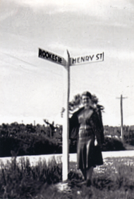
Photograph, Road signs - No roads
... Road signs - No roads ...Sent to a parishioner at Christ Church Mitcham, by Phyllis Grant who lived at the Migrant Hostel in Mitcham in 1952-54, where her husband did development work under the P.M.G.Black and white photograph of road signs in Rooks Road. Note spelling of Rookes which is incorrect and Henry Street which no longer exists. It is presumed that it pointed to a street which lost its identity with the development of the Migrant Hostelrooks road mitcham -
 Bacchus Marsh & District Historical Society
Map, Maddingley Township, Parish of Parwan, 1880s
This map is dated Sept. 6th 1856. However places in the township of Maddingley which did not appear until the late 1880s such as the Bacchus Marsh Railway Station and line are shown on this map in their correct locations. This suggests the map has been derived from an earlier map. An earlier date of 1843 with a surveyor's name preceding it can also be seen on the map. The map is important because it indicates the location and dimensions of early but now discontinued use of land such as the showgrounds and police paddock and a site reserved for the Church of England which was not ultimately used for a permanent church. A single page paper map showing land allotments, streets, rivers, creeks, park lands, the railway line and Bacchus Marsh railway station in the township of Maddingley. The map is pasted into a bound volume containing 76 maps or plans in total. Bottom of Map: Surveyor-General's Office, Melbourne, Sept 6th, 1856bacchus marsh victoria maps, maddingley victoria maps, land use, maddingley victoria history -
 Victorian Railway History Library
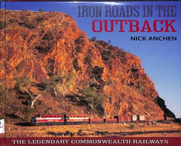
Book, Nick Anchen, Iron Roads in the Outback, 2017
... Iron Roads in the Outback ...The Iron Roads of the Australian Outback - the legendary Commonwealth Railways were built through some of the harshest landscapes on Earth. They were railways like no other, where men and women battled extreme temperatures, flash floods and maddening isolation to keep the trains running. This publication is the culmination of 25 years of Outback exploration, research, photography and interviews by author Nick Anchen. The result is a diverse book which brings to life both the beauty and harshness of the Australian Outback, through a collection of fascinating and historic images, along with the memories of former Commonwealth Railways employees. Following an introductory chapter on the vastness and grandeur of the Australian interior - highlighted by the memoirs of 1950s flying doctor Macarthur Job - the book delves into the story of the Central Australia Railway. This was the line built through the 'back of beyond' - the forbidding desert country of South Australia and the Northern Territory. It was here that operators of famous trains such as The Ghan battled searing heat, dust storms and raging floodwaters to keep the trains running. The chapter includes stories by well known Ghan conductor 'Aspro' Lyons, and 'Piano Playing Chef' Paddy Greenfield - along with enginemen Wolf Markowski and John Theel, both of whom worked trains on this famous railway. The story of the North Australia Railway - 'The Line to Nowhere' - is the tale of a ramshackle railway which came alive during the dark days of World War II. The memoirs of wartime engineman Jim Prentice are eye opening, as are the hair raising accounts of surviving Tropical Cyclone Tracy, as told by rolling stock foreman Bill Donaldson. The Trans-Australian Railway was built across one of the harshest and loneliest environments on Earth - the vast Nullarbor Plain. Stories from enginemen Jack Slattery and Ron Howrie, along with Nullarbor resident and roadmaster's wife Cathy Beek, tell not only of the rudimentary living conditions and maddening isolation, but of the great camaraderie amongst the railway people who kept trains such as the Trans-Australian and the Tea and Sugar running. As well as examining the ruins and relics from the long-closed CR narrow gauge lines, the book also includes a chapter on the much-loved Pichi Richi Railway - the last surviving portion of that great Transcontinental Railway dream from another age.ill, maps, p.208.non-fictionThe Iron Roads of the Australian Outback - the legendary Commonwealth Railways were built through some of the harshest landscapes on Earth. They were railways like no other, where men and women battled extreme temperatures, flash floods and maddening isolation to keep the trains running. This publication is the culmination of 25 years of Outback exploration, research, photography and interviews by author Nick Anchen. The result is a diverse book which brings to life both the beauty and harshness of the Australian Outback, through a collection of fascinating and historic images, along with the memories of former Commonwealth Railways employees. Following an introductory chapter on the vastness and grandeur of the Australian interior - highlighted by the memoirs of 1950s flying doctor Macarthur Job - the book delves into the story of the Central Australia Railway. This was the line built through the 'back of beyond' - the forbidding desert country of South Australia and the Northern Territory. It was here that operators of famous trains such as The Ghan battled searing heat, dust storms and raging floodwaters to keep the trains running. The chapter includes stories by well known Ghan conductor 'Aspro' Lyons, and 'Piano Playing Chef' Paddy Greenfield - along with enginemen Wolf Markowski and John Theel, both of whom worked trains on this famous railway. The story of the North Australia Railway - 'The Line to Nowhere' - is the tale of a ramshackle railway which came alive during the dark days of World War II. The memoirs of wartime engineman Jim Prentice are eye opening, as are the hair raising accounts of surviving Tropical Cyclone Tracy, as told by rolling stock foreman Bill Donaldson. The Trans-Australian Railway was built across one of the harshest and loneliest environments on Earth - the vast Nullarbor Plain. Stories from enginemen Jack Slattery and Ron Howrie, along with Nullarbor resident and roadmaster's wife Cathy Beek, tell not only of the rudimentary living conditions and maddening isolation, but of the great camaraderie amongst the railway people who kept trains such as the Trans-Australian and the Tea and Sugar running. As well as examining the ruins and relics from the long-closed CR narrow gauge lines, the book also includes a chapter on the much-loved Pichi Richi Railway - the last surviving portion of that great Transcontinental Railway dream from another age. commonwealth railways (australia) -- history., central australia railway -- history. -
 Victorian Aboriginal Corporation for Languages
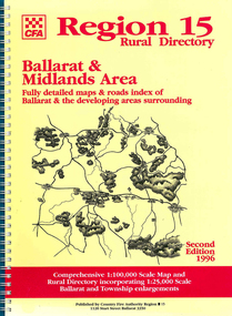
Map, Country Fire Authority, Region 15 rural directory : Ballarat &? Midlands Area : fully detailed maps &? roads index of Ballarat &? the developing areas surrounding, 1996
... : fully detailed maps &? roads index of Ballarat &? the developing ...mapsballarat, fire protection, victorian regional maps, emergency services -
 Victorian Aboriginal Corporation for Languages
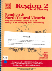
Map, Country Fire Authority, Region 2 rural directory : Bendigo &? North Central Victoria: fully detailed maps &? roads index of Bendigo &? the developing areas surrounding, 1996
... Victoria: fully detailed maps &? roads index of Bendigo &? the ...mapsbendigo, loddon, fire protection, victorian regional maps, directories -
 Federation University Historical Collection
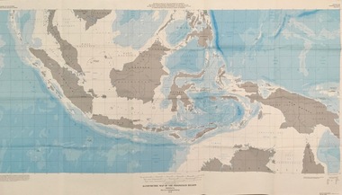
Map - Geological, U.S. Government Printing Office, Bathymetric Map of the Indonesian Region: Folio of the Indonesian Region Map I-875-A, 1974, 1974
Map was prepared on behalf of the Government of Indonesia, The United Nations Economic Commission for Asia and the Far East, the Agency for International Development and the U.S. Department of State in cooperation with the Geological Survey of Indonesia. The area covered shows the islands and seas from Latitude 12 degree North to 16 degrees South and Longitude 90 degrees to 148 degrees. Various water features are also named.Large map showing the Indonesian area - islands and seasLongitude and Latitude are shown. Major / Capitol cities indicated. Names of those responsible for the productionindonesia, united nations economic commission, department of state, geological survey, latitude, longitude, government of indonesia -
Port Melbourne Historical & Preservation Society
Book - Promotional, Media Unit, Port of Melbourne Authority, Port Of Melbourne, 1990
'Port of Melbourne', a promotional book describing the PMA and its work and promoting Melbourne's value as the larget container port in the southern hemisphere.melbourne harbor trust - port of melbourne authority -
Stawell Historical Society Inc
Map, P Jones, Shire of Stawell Roads and Reserves, 1989
... Shire of Stawell Roads and Reserves ...Shows Woodlands Forests & Open WoodlandTwo Copies (2) map With roads around Stawell. Forests Woodlands 2 Very open Woodlands Coloured.Drawn P Jones. May 1989. Last Amended 25 may 1989