Showing 434 items matching "suburban street"
-
 Kew Historical Society Inc
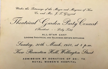
Document - Entrance Ticket, Theatrical Garden Party Concert, 1958
Arthur Henry Dear was an employee of the City of Kew, acting as Hall Keeper of the Kew Recreation Hall in Wellington Street, and later the new Kew City Hall in Cotham Road. The Arthur Dear Collection contains memorabilia - tickets, programmes, invitations - as well as his identification badge. Items in the collection dates from the 1940s to the 1970s. The Kew Recreation Hall (Wellington Street) and later the Kew City Hall (Cotham Road) were major locations in suburban Melbourne in the postwar period for civic and private events including theatre productions and exhibitions. The Arthur Dear Collection (in conjunction with the scrapbooks compiled by Marion Tilley) provide a comprehensive snapshot of performing arts in Kew during the 1940s, 1950s and 1960s. The collection includes valuable data about performances, performers, directors etc., during this period.Ticket issued for a Theatrical Garden Party in the Kew Recreation Hall under the patronage of the Mayor and Maoyoress of Kew, Cr. and Mrs J.T. Gazzard on 30 March 1958.Ticket numbered on reverse: "212"cr jo gazzard, mayors of kew, arthur dear collection, performing arts -- kew -- victoria, kew recreation hall -- wellington street, city of kew, theatre memorabilia -
 Kew Historical Society Inc
Document, Letter of Donation, Arthur Dear Collection / from Mary Dear, 2011, 14/01/2011
Arthur Henry Dear was an employee of the City of Kew, acting as Hall Keeper of the Kew Recreation Hall in Wellington Street, and later the new Kew City Hall in Cotham Road. The Arthur Dear Collection contains memorabilia - tickets, programmes, invitations - as well as his identification badge. Items in the collection dates from the 1940s to the 1960s. The Kew Recreation Hall (Wellington Street) and later the Kew City Hall (Cotham Road) were major locations in suburban Melbourne in the postwar period for civic and private events including theatre productions and exhibitions. The Arthur Dear Collection (in conjunction with the scrapbooks compiled by Marion Tilley) provide a comprehensive snapshot of performing arts in Kew during the 1940s, 1950s and 1960s. The collection includes valuable data about performances, performers, directors etc., during this period. Letter to the Kew Historical Society relating to the donation of the Arthur Dear Collection by the donor.14TH JANUARY 2011 / KEW HISTORICAL SOCIETY INC / P/O BOX 175 / KEW 3101 / Dear Sir/Madam / My name is Mary Tracey (nee DEAR). My later father, ARTHUR HENRY DEAR was caretaker of the KEW RECREATION HALL from approximately 1945 to 1959 when the HALL was demolished by the KEW BOWLING CLUB. Please find enclosed some Programmes of events that took place at the HALL during that period of time. Hoping they may be of some interest, yours sincerely MARY TRACEY, ****arthur dear collection, performing arts -- kew -- victoria, kew recreation hall -- wellington street, kew civic hall -- cotham road, city of kew -
 Kew Historical Society Inc
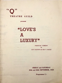
Programme, The "Q" Theatre Guild, Love's a Luxury, 1959
The "Q" Theatre Guild grew out of and amalgamated the Kew Light Opera Company in 1957. Productions were initially held in the Kew Recreation Hall and subsequently in the Kew Civic Hall. The Company would appear to have run until the mid-1960s. Arthur Henry Dear was an employee of the City of Kew, acting as Hall Keeper of the Kew Recreation Hall in Wellington Street, and later the new Kew City Hall in Cotham Road. The Arthur Dear Collection contains memorabilia - tickets, programmes, invitations - as well as his identification badge. Items in the collection dates from the 1940s to the 1960s.The Kew Recreation Hall (Wellington Street) and later the Kew City Hall (Cotham Road) were major locations in suburban Melbourne in the postwar period for civic and private events including theatre productions and exhibitions. The Arthur Dear Collection (in conjunction with the scrapbooks compiled by Marion Tilley) provide a comprehensive snapshot of performing arts in Kew during the 1940s, 1950s and 1960s. The collection includes valuable data about performances, performers, directors etc., during this period. Theatre programme. "Q" Theatre Guild presents "Love's A Luxury": Farcical Comedy by Guy Paxtion and Ed. V. Haile. Four page bi-fold programme listing title, dates of performance, cast list, production details, and advertisements. 4pp.arthur dear collection, performing arts -- kew -- victoria, kew recreation hall -- wellington street, theatre memorabilia, 'q' theatre guild -
 Kew Historical Society Inc
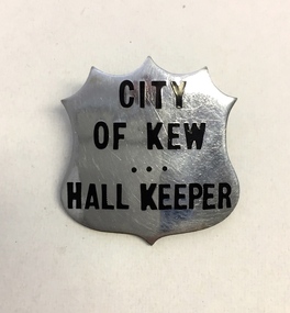
Functional object, City of Kew, Hall Keeper Badge, c.1949
The former City of Kew in Victoria issued badges to council employees performing public roles. The Society has other badges issued by the City for roles such as Parking Attendant, Swimming Pool Attendant etc. Arthur Henry Dear was an employee of the City of Kew, acting as Hall Keeper of the Kew Recreation Hall in Wellington Street, and later the new Kew City Hall in Cotham Road. The Arthur Dear Collection contains memorabilia - tickets, programmes, invitations - as well as his identification badge. Items in the collection dates from the 1940s to the 1960s. The Kew Recreation Hall (Wellington Street) and later the Kew City Hall (Cotham Road) were major locations in suburban Melbourne in the postwar period for civic and private events including theatre productions and exhibitions. The Arthur Dear Collection (in conjunction with the scrapbooks compiled by Marion Tilley) provide a comprehensive snapshot of performing arts in Kew during the 1940s, 1950s and 1960s. The collection includes valuable data about performances, performers, directors etc., during this period. A nickel and enamel identification badge issued to the hall keeper of the Kew Recreation Hall by the City of Kew. The badge is shaped like a shield and is stamped with the users' title.arthur dear collection, performing arts -- kew -- victoria, kew recreation hall -- wellington street, kew civic hall -- cotham road, city of kew -
 Kew Historical Society Inc
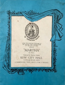
Programme - Opera Programme, Shipping Newspapers, 'Martha' / by Flotow, 1963
The "Q" Theatre Guild grew out of and amalgamated the Kew Light Opera Company in 1957. Productions were initially held in the Kew Recreation Hall and subsequently in the Kew Civic Hall. The Company would appear to have run until the mid-1960s. Arthur Henry Dear was an employee of the City of Kew, acting as Hall Keeper of the Kew Recreation Hall in Wellington Street, and later the new Kew City Hall in Cotham Road. The Arthur Dear Collection contains memorabilia - tickets, programmes, invitations - as well as his identification badge. Items in the collection dates from the 1940s to the 1960s. The Kew Recreation Hall (Wellington Street) and later the Kew City Hall (Cotham Road) were major locations in suburban Melbourne in the postwar period for civic and private events including theatre productions and exhibitions. The Arthur Dear Collection (in conjunction with the scrapbooks compiled by Marion Tilley) provide a comprehensive snapshot of performing arts in Kew during the 1940s, 1950s and 1960s. The collection includes valuable data about performances, performers, directors etc., during this period. Theatrical programme. "Q" Theatre Guild presents Martha by Flotow. Produced by Beatrice Oakley, Kew City Hall, Cotham Road, Kew Commencing Wed., May 8 [1963] for 4 nights. 16pp. Includes title page, cast list, some profiles, and advertisements.arthur dear collection, performing arts -- kew -- victoria, kew civic hall -- cotham road, city of kew, theatre memorabilia -
 Kew Historical Society Inc
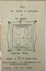
Programme - Theatre Programme, The Mystery and Christmas Revels, 1957-1959
The "Q" Theatre Guild grew out of and amalgamated the Kew Light Opera Company in 1957. Productions were initially held in the Kew Recreation Hall and subsequently in the Kew Civic Hall. The Company would appear to have run until the mid-1960s. Arthur Henry Dear was an employee of the City of Kew, acting as Hall Keeper of the Kew Recreation Hall in Wellington Street, and later the new Kew City Hall in Cotham Road. The Arthur Dear Collection contains memorabilia - tickets, programmes, invitations - as well as his identification badge. Items in the collection dates from the 1940s to the 1960s. The Kew Recreation Hall (Wellington Street) and later the Kew City Hall (Cotham Road) were major locations in suburban Melbourne in the postwar period for civic and private events including theatre productions and exhibitions. The Arthur Dear Collection (in conjunction with the scrapbooks compiled by Marion Tilley) provide a comprehensive snapshot of performing arts in Kew during the 1940s, 1950s and 1960s. The collection includes valuable data about performances, performers, directors etc., during this period.Theatrical programme issued by the "Q" Theatre Guild. The undated 20-page programme lists the cast members of the Guild and the details of the programme.The event must have occurred between 1957 and 1959.arthur dear collection, performing arts -- kew -- victoria, kew recreation hall -- wellington street, city of kew, theatre memorabilia -
 Kew Historical Society Inc
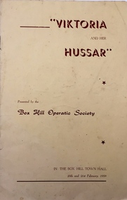
Programme, Box Hill Operatic Society, 'Viktoria and Her Hussar' by Grunwald & Lohner-Benda /, 1958
The Box Hill Operatic Society was founded in 1945 and was sponsored by the Box Hill City Council. Past productions listed on the back page of the programme include The Quaker Girl, High Jinks, A Night Out, The Lilac Domino, Wildflower, Gipsy Love, Katinka, and Maid of the Mountains. Arthur Henry Dear was an employee of the City of Kew, acting as Hall Keeper of the Kew Recreation Hall in Wellington Street, and later the new Kew City Hall in Cotham Road. The Arthur Dear Collection contains memorabilia - tickets, programmes, invitations - as well as his identification badge. Items in the collection dates from the 1940s to the 1960s. The Kew Recreation Hall (Wellington Street) and later the Kew City Hall (Cotham Road) were major locations in suburban Melbourne in the postwar period for civic and private events including theatre productions and exhibitions. The Arthur Dear Collection (in conjunction with the scrapbooks compiled by Marion Tilley) provide a comprehensive snapshot of performing arts in Kew during the 1940s, 1950s and 1960s. The collection includes valuable data about performances, performers, directors etc., during this period. Theatre programme issued by the Box Hill Operatic Society. The 8-page programme contains a title page, a cast list, details of the management, and a brief history of the Company. The performance was held in the Box Hill Town Hall in 1958. arthur dear collection, theatre memorabilia, performing arts - box hill, box hill town hall -
 Kew Historical Society Inc
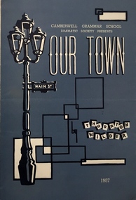
Programme, 'Our Town' / by Thornton Wilder, 1957
The back page of the programme includes details of previous productions: 1950 - The Resignation of Mr. Bagsworth, The Shirt, 1951 - Richard of Bordeaux, 1952 - Ned Kelly, 1953 - Saint Joan, 1954 - Treasure Island 1955 - Toad of Toad Hall, and 1956 School for Scandal. Arthur Henry Dear was an employee of the City of Kew, acting as Hall Keeper of the Kew Recreation Hall in Wellington Street, and later the new Kew City Hall in Cotham Road. The Arthur Dear Collection contains memorabilia - tickets, programmes, invitations - as well as his identification badge. Items in the collection dates from the 1940s to the 1960s. The Kew Recreation Hall (Wellington Street) and later the Kew City Hall (Cotham Road) were major locations in suburban Melbourne in the postwar period for civic and private events including theatre productions and exhibitions. The Arthur Dear Collection (in conjunction with the scrapbooks compiled by Marion Tilley) provide a comprehensive snapshot of performing arts in Kew during the 1940s, 1950s and 1960s. The collection includes valuable data about performances, performers, directors etc., during this period. Theatre programme for a production of Our Town by the Camberwell Grammar School Dramatic Society. The 4-page programme includes a cast list and information about supernumeraries. arthur dear collection, performing arts -- kew -- victoria, kew recreation hall -- wellington street, theatre memorabilia, camberwell grammar school dramatic society -
 Kew Historical Society Inc
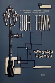
Programme, Camberwell Grammar School Dramatic Society, 'Our Town' / by Thornton Wilder, 1957
The back page of the programme includes details of previous productions: 1950 - The Resignation of Mr. Bagsworth, The Shirt, 1951 - Richard of Bordeaux, 1952 - Ned Kelly, 1953 - Saint Joan, 1954 - Treasure Island 1955 - Toad of Toad Hall, and 1956 School for Scandal.The Kew Recreation Hall (Wellington Street) and later the Kew City Hall (Cotham Road) were major locations in suburban Melbourne in the postwar period for civic and private events including theatre productions and exhibitions. The Arthur Dear Collection (in conjunction with the scrapbooks compiled by Marion Tilley) provide a comprehensive snapshot of performing arts in Kew during the 1940s, 1950s and 1960s. The collection includes valuable data about performances, performers, directors etc., during this period. Theatre programme for a production of Our Town by the Camberwell Grammar School Dramatic Society. The 4-page programme includes a cast list and information about supernumeraries. arthur dear collection, theatre memorabilia, theatre programmes, camberwell grammar school dramatic society -
 Kew Historical Society Inc
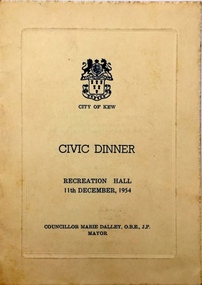
Programme, City of Kew, Civic Dinner, 1954, 1954
Arthur Henry Dear was an employee of the City of Kew, acting as Hall Keeper of the Kew Recreation Hall in Wellington Street, and later the new Kew City Hall in Cotham Road. The Arthur Dear Collection contains memorabilia - tickets, programmes, invitations - as well as his identification badge. Items in the collection dates from the 1940s to the 1960s.The Kew Recreation Hall (Wellington Street) and later the Kew City Hall (Cotham Road) were major locations in suburban Melbourne in the postwar period for civic and private events including theatre productions and exhibitions. The Arthur Dear Collection (in conjunction with the scrapbooks compiled by Marion Tilley) provide a comprehensive snapshot of performing arts in Kew during the 1940s, 1950s and 1960s. The collection includes valuable data about performances, performers, directors etc., during this period. Programme for a Civic Dinner in the Kew Recreation Hall hosted by the Mayor of Kew, Cr. Marie Dalley, on 11 December 1954. The programme lists Toasts, Musical Items and the Menu.arthur dear collection, city of kew -- civic dinners, kew recreation hall -
 Kew Historical Society Inc
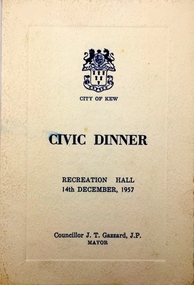
Programme, City of Kew, Civic Dinner, 1957, 1957
Arthur Henry Dear was an employee of the City of Kew, acting as Hall Keeper of the Kew Recreation Hall in Wellington Street, and later the new Kew City Hall in Cotham Road. The Arthur Dear Collection contains memorabilia - tickets, programmes, invitations - as well as his identification badge. Items in the collection dates from the 1940s to the 1960s.The Kew Recreation Hall (Wellington Street) and later the Kew City Hall (Cotham Road) were major locations in suburban Melbourne in the postwar period for civic and private events including theatre productions and exhibitions. The Arthur Dear Collection (in conjunction with the scrapbooks compiled by Marion Tilley) provide a comprehensive snapshot of performing arts in Kew during the 1940s, 1950s and 1960s. The collection includes valuable data about performances, performers, directors etc., during this period. Programme for a Civic Dinner in the Kew Recreation Hall hosted by the Mayor of Kew, Cr. J.T. Gazzard, on 14 December 1957. The programme lists Toasts, Musical Items and the Menu.arthur dear collection, cr. gazzard, civic dinner, city of kew, kew recreation hall -- wellington street, city of kew - civic dinners -
 Kew Historical Society Inc
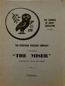
Programme, 'The Miser' by Moliere, 1951
Arthur Henry Dear was an employee of the City of Kew, acting as Hall Keeper of the Kew Recreation Hall in Wellington Street, and later the new Kew City Hall in Cotham Road. The Arthur Dear Collection contains memorabilia - tickets, programmes, invitations - as well as his identification badge. Items in the collection dates from the 1940s to the 1960s. The Kew Recreation Hall (Wellington Street) and later the Kew City Hall (Cotham Road) were major locations in suburban Melbourne in the postwar period for civic and private events including theatre productions and exhibitions. The Arthur Dear Collection (in conjunction with the scrapbooks compiled by Marion Tilley) provide a comprehensive snapshot of performing arts in Kew during the 1940s, 1950s and 1960s. The collection includes valuable data about performances, performers, directors etc., during this period. Programme for a performance of The Miser by Moliere by The Everyman Theatres Company in association with the Council of Adult Education. The text was adapted by Miles Malleson. The 12-page programme includes a cast list, individual performer profiles and notes regarding the history of Everyman Theatres Company. arthur dear collection, performing arts -- kew -- victoria, kew recreation hall -- wellington street, theatre memorabilia, the everyman theatres company -
 Kew Historical Society Inc
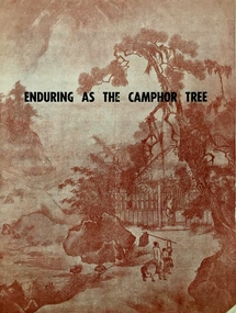
Programme - Theatre Programme, 'Enduring As the Camphor Tree' by Russell J. Oakes, 1952
Arthur Henry Dear was an employee of the City of Kew, acting as Hall Keeper of the Kew Recreation Hall in Wellington Street, and later the new Kew City Hall in Cotham Road. The Arthur Dear Collection contains memorabilia - tickets, programmes, invitations - as well as his identification badge. Items in the collection dates from the 1940s to the 1960s. The Kew Recreation Hall (Wellington Street) and later the Kew City Hall (Cotham Road) were major locations in suburban Melbourne in the postwar period for civic and private events including theatre productions and exhibitions. The Arthur Dear Collection (in conjunction with the scrapbooks compiled by Marion Tilley) provide a comprehensive snapshot of performing arts in Kew during the 1940s, 1950s and 1960s. The collection includes valuable data about performances, performers, directors etc., during this period.Programme for a performance of Enduring As the Camphor Tree by Russell J. Oakes, performed by The Everyman Theatres Company. The programme includes performer and writer profiles as well as a cast list and advertisements.arthur dear collection, performing arts -- kew -- victoria, kew recreation hall -- wellington street, theatre memorabilia, everyman theatres company, 'enduring as the camphor tree' by russell j. oakes -
 Kew Historical Society Inc
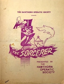
Programme - Theatre Programme, Hawthorn Operatic Society, 'The Sorcerer' by Gilbert & Sullivan, 1956
Arthur Henry Dear was an employee of the City of Kew, acting as Hall Keeper of the Kew Recreation Hall in Wellington Street, and later the new Kew City Hall in Cotham Road. The Arthur Dear Collection contains memorabilia - tickets, programmes, invitations - as well as his identification badge. Items in the collection dates from the 1940s to the 1960s. The Kew Recreation Hall (Wellington Street) and later the Kew City Hall (Cotham Road) were major locations in suburban Melbourne in the postwar period for civic and private events including theatre productions and exhibitions. The Arthur Dear Collection (in conjunction with the scrapbooks compiled by Marion Tilley) provide a comprehensive snapshot of performing arts in Kew during the 1940s, 1950s and 1960s. The collection includes valuable data about performances, performers, directors etc., during this period. 4-page programme for a performance by the Hawthorn Operatic Society of Gilbert and Sullivan's The Sorcerer at the Kew Recreation Hall in June 1956.arthur dear collection, performing arts -- kew -- victoria, kew recreation hall -- wellington street, theatre memorabilia, hawthorn operatic society -
 Kew Historical Society Inc
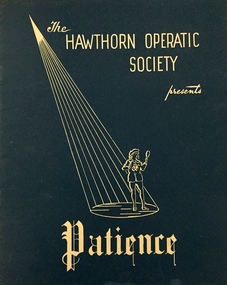
Programme - Theatre Programme, 'Patience' by Gilbert & Sullivan, 1957
Arthur Henry Dear was an employee of the City of Kew, acting as Hall Keeper of the Kew Recreation Hall in Wellington Street, and later the new Kew City Hall in Cotham Road. The Arthur Dear Collection contains memorabilia - tickets, programmes, invitations - as well as his identification badge. Items in the collection dates from the 1940s to the 1960s. The Kew Recreation Hall (Wellington Street) and later the Kew City Hall (Cotham Road) were major locations in suburban Melbourne in the postwar period for civic and private events including theatre productions and exhibitions. The Arthur Dear Collection (in conjunction with the scrapbooks compiled by Marion Tilley) provide a comprehensive snapshot of performing arts in Kew during the 1940s, 1950s and 1960s. The collection includes valuable data about performances, performers, directors etc., during this period. Programme for a performance of Gilbert and Sullivan's Patience by the Hawthorn Operatic Society in 1957. 14 pp.arthur dear collection, performing arts -- kew -- victoria, kew recreation hall -- wellington street, theatre memorabilia, hawthorn operatic society -
 Kew Historical Society Inc
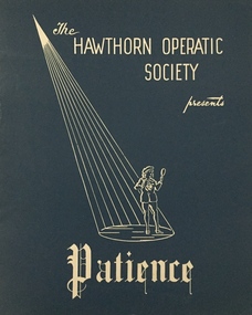
Programme - Theatre Programme, 'Patience' by Gilbert & Sullivan, 1957
Arthur Henry Dear was an employee of the City of Kew, acting as Hall Keeper of the Kew Recreation Hall in Wellington Street, and later the new Kew City Hall in Cotham Road. The Arthur Dear Collection contains memorabilia - tickets, programmes, invitations - as well as his identification badge. Items in the collection dates from the 1940s to the 1960s.The Kew Recreation Hall (Wellington Street) and later the Kew City Hall (Cotham Road) were major locations in suburban Melbourne in the postwar period for civic and private events including theatre productions and exhibitions. The Arthur Dear Collection (in conjunction with the scrapbooks compiled by Marion Tilley) provide a comprehensive snapshot of performing arts in Kew during the 1940s, 1950s and 1960s. The collection includes valuable data about performances, performers, directors etc., during this period. Programme for a performance of Gilbert and Sullivan's Patience by the Hawthorn Operatic Society in 1957. 14 pp.arthur dear collection, performing arts -- kew -- victoria, kew recreation hall -- wellington street, theatre memorabilia, hawthorn operatic society -
 Kew Historical Society Inc
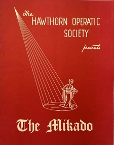
Programme - Theatre Programme, Hawthorn Operatic Society, 'The Mikado' by Gilbert & Sullivan, 1959
Arthur Henry Dear was an employee of the City of Kew, acting as Hall Keeper of the Kew Recreation Hall in Wellington Street, and later the new Kew City Hall in Cotham Road. The Arthur Dear Collection contains memorabilia - tickets, programmes, invitations - as well as his identification badge. Items in the collection dates from the 1940s to the 1960s.The Kew Recreation Hall (Wellington Street) and later the Kew City Hall (Cotham Road) were major locations in suburban Melbourne in the postwar period for civic and private events including theatre productions and exhibitions. The Arthur Dear Collection (in conjunction with the scrapbooks compiled by Marion Tilley) provide a comprehensive snapshot of performing arts in Kew during the 1940s, 1950s and 1960s. The collection includes valuable data about performances, performers, directors etc., during this period. Programme for a performance of Gilbert and Sullivan's The Mikado by the Hawthorn Operatic Society in 1959. 12 pp.arthur dear collection, performing arts -- kew -- victoria, kew recreation hall -- wellington street, theatre memorabilia, hawthorn operatic society -
 Kew Historical Society Inc
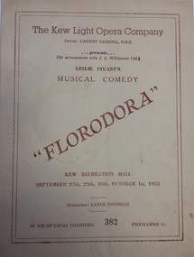
Programme - Theatre Programme, Florodora / by Leslie Stuart, 1952
The Kew Light Opera Company was formed in 1952. Its first production, held in the Kew Recreation Hall was Leslie Stuart's Florodora. In 1957, the Company was subsumed in the "Q" Theatre Guild.Arthur Henry Dear was an employee of the City of Kew, acting as Hall Keeper of the Kew Recreation Hall in Wellington Street, and later the new Kew City Hall in Cotham Road. The Arthur Dear Collection contains memorabilia - tickets, programmes, invitations - as well as his identification badge. Items in the collection dates from the 1940s to the 1960s. The Kew Recreation Hall (Wellington Street) and later the Kew City Hall (Cotham Road) were major locations in suburban Melbourne in the postwar period for civic and private events including theatre productions and exhibitions. The Arthur Dear Collection (in conjunction with the scrapbooks compiled by Marion Tilley) provide a comprehensive snapshot of performing arts in Kew during the 1940s, 1950s and 1960s. The collection includes valuable data about performances, performers, directors etc., during this period. Theatre programme for a production of Florodora in the Kew Recreation Hall by the Kew Light Opera Company. The 12-page programme includes profiles, a cast list and advertisements. An annotation on the acknowledgements page by Arthur Dear, the Hall Keeper, records that he was responsible for cleaning up the mess afterwardsarthur dear collection, performing arts -- kew -- victoria, kew recreation hall -- wellington street, theatre memorabilia, kew light opera company, florodora - leslie stuart -
 Kew Historical Society Inc
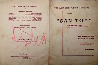
Programme - Theatre Programme, San Toy / by Sidney Jones, 1953
The Kew Light Opera Company was formed in 1952. Its first production, held in the Kew Recreation Hall was Leslie Stuart's Florodora. In 1957, the Company was subsumed in the "Q" Theatre Guild.Arthur Henry Dear was an employee of the City of Kew, acting as Hall Keeper of the Kew Recreation Hall in Wellington Street, and later the new Kew City Hall in Cotham Road. The Arthur Dear Collection contains memorabilia - tickets, programmes, invitations - as well as his identification badge. Items in the collection dates from the 1940s to the 1960s. The Kew Recreation Hall (Wellington Street) and later the Kew City Hall (Cotham Road) were major locations in suburban Melbourne in the postwar period for civic and private events including theatre productions and exhibitions. The Arthur Dear Collection (in conjunction with the scrapbooks compiled by Marion Tilley) provide a comprehensive snapshot of performing arts in Kew during the 1940s, 1950s and 1960s. The collection includes valuable data about performances, performers, directors etc., during this period.Theatre programme for a production of San Toy in the Kew Recreation Hall by the Kew Light Opera Company. The 4-page programme includes profiles, a cast list and advertisements. arthur dear collection, performing arts -- kew -- victoria, kew recreation hall -- wellington street, kew civic hall -- cotham road, city of kew, theatre memorabilia, kew light opera company -
 Kew Historical Society Inc
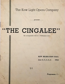
Programme - Theatre Programme, The Cingalee / by Lionel Monckton, 1953
The Kew Light Opera Company was formed in 1952. Its first production, held in the Kew Recreation Hall was Leslie Stuart's Florodora. In 1957, the Company was subsumed in the "Q" Theatre Guild.Arthur Henry Dear was an employee of the City of Kew, acting as Hall Keeper of the Kew Recreation Hall in Wellington Street, and later the new Kew City Hall in Cotham Road. The Arthur Dear Collection contains memorabilia - tickets, programmes, invitations - as well as his identification badge. Items in the collection dates from the 1940s to the 1960s. The Kew Recreation Hall (Wellington Street) and later the Kew City Hall (Cotham Road) were major locations in suburban Melbourne in the postwar period for civic and private events including theatre productions and exhibitions. The Arthur Dear Collection (in conjunction with the scrapbooks compiled by Marion Tilley) provide a comprehensive snapshot of performing arts in Kew during the 1940s, 1950s and 1960s. The collection includes valuable data about performances, performers, directors etc., during this period. Theatre programme for a production of The Cingalee in the Kew Recreation Hall by the Kew Light Opera Company. The 10-page programme includes profiles, a cast list and advertisements. arthur dear collection, performing arts -- kew -- victoria, kew recreation hall -- wellington street, city of kew, theatre memorabilia, the cingalee, kew light opera company -
 Kew Historical Society Inc
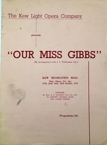
Programme - Theatre Programme, Our Miss Gibbs / by Lionel Monckton & Ivan Caryll, 1954
The Kew Light Opera Company was formed in 1952. Its first production, held in the Kew Recreation Hall was Leslie Stuart's Florodora. In 1957, the Company was subsumed in the "Q" Theatre Guild.Arthur Henry Dear was an employee of the City of Kew, acting as Hall Keeper of the Kew Recreation Hall in Wellington Street, and later the new Kew City Hall in Cotham Road. The Arthur Dear Collection contains memorabilia - tickets, programmes, invitations - as well as his identification badge. Items in the collection dates from the 1940s to the 1960s.The Kew Recreation Hall (Wellington Street) and later the Kew City Hall (Cotham Road) were major locations in suburban Melbourne in the postwar period for civic and private events including theatre productions and exhibitions. The Arthur Dear Collection (in conjunction with the scrapbooks compiled by Marion Tilley) provide a comprehensive snapshot of performing arts in Kew during the 1940s, 1950s and 1960s. The collection includes valuable data about performances, performers, directors etc., during this period. Theatre programme for a production of Our Miss Gibbs in the Kew Recreation Hall by the Kew Light Opera Company. The 4-page programme includes a cast list and a synopsis. 4 pp.arthur dear collection, kew light opera company, kew recreation hall, musicals, programmes, theatre, theatrical performances, performing arts, our miss gibbs -
 Kew Historical Society Inc
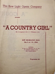
Programme - Theatre Programme, A Country Girl / by Lionel Monckton, 1954
The Kew Light Opera Company was formed in 1952. Its first production, held in the Kew Recreation Hall was Leslie Stuart's Florodora. In 1957, the Company was subsumed in the "Q" Theatre Guild.Arthur Henry Dear was an employee of the City of Kew, acting as Hall Keeper of the Kew Recreation Hall in Wellington Street, and later the new Kew City Hall in Cotham Road. The Arthur Dear Collection contains memorabilia - tickets, programmes, invitations - as well as his identification badge. Items in the collection dates from the 1940s to the 1960s. The Kew Recreation Hall (Wellington Street) and later the Kew City Hall (Cotham Road) were major locations in suburban Melbourne in the postwar period for civic and private events including theatre productions and exhibitions. The Arthur Dear Collection (in conjunction with the scrapbooks compiled by Marion Tilley) provide a comprehensive snapshot of performing arts in Kew during the 1940s, 1950s and 1960s. The collection includes valuable data about performances, performers, directors etc., during this period. Theatre programme for a production of A Country Girl in the Kew Recreation Hall by the Kew Light Opera Company. The 4-page programme includes a cast list and a synopsis. arthur dear collection, performing arts -- kew -- victoria, kew recreation hall -- wellington street, city of kew, theatre memorabilia, kew light opera company -
 Kew Historical Society Inc
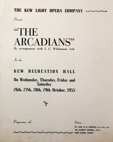
Programme - Theatre Programme, The Arcadians / by Mark Ambient & A.M. Thompson, 1955
The Kew Light Opera Company was formed in 1952. Its first production, held in the Kew Recreation Hall was Leslie Stuart's Florodora. In 1957, the Company was subsumed in the "Q" Theatre Guild.Arthur Henry Dear was an employee of the City of Kew, acting as Hall Keeper of the Kew Recreation Hall in Wellington Street, and later the new Kew City Hall in Cotham Road. The Arthur Dear Collection contains memorabilia - tickets, programmes, invitations - as well as his identification badge. Items in the collection dates from the 1940s to the 1960s. The Kew Recreation Hall (Wellington Street) and later the Kew City Hall (Cotham Road) were major locations in suburban Melbourne in the postwar period for civic and private events including theatre productions and exhibitions. The Arthur Dear Collection (in conjunction with the scrapbooks compiled by Marion Tilley) provide a comprehensive snapshot of performing arts in Kew during the 1940s, 1950s and 1960s. The collection includes valuable data about performances, performers, directors etc., during this period.Theatre programme for a production of The Arcadians in the Kew Recreation Hall by the Kew Light Opera Company. The 4-page programme includes a cast list and a synopsis. the arcadians, mark ambient, a.m. thompson, arthur dear collection, performing arts -- kew -- victoria, kew recreation hall -- wellington street, theatre memorabilia -
 Kew Historical Society Inc
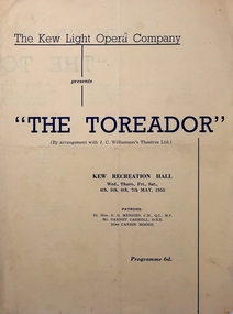
Programme - Theatre Programme, The Toreador / by Ivan Caryll & Lionel Monckton, 1955
The Kew Light Opera Company was formed in 1952. Its first production, held in the Kew Recreation Hall was Leslie Stuart's Florodora. In 1957, the Company was subsumed in the "Q" Theatre Guild.Arthur Henry Dear was an employee of the City of Kew, acting as Hall Keeper of the Kew Recreation Hall in Wellington Street, and later the new Kew City Hall in Cotham Road. The Arthur Dear Collection contains memorabilia - tickets, programmes, invitations - as well as his identification badge. Items in the collection dates from the 1940s to the 1960s. The Kew Recreation Hall (Wellington Street) and later the Kew City Hall (Cotham Road) were major locations in suburban Melbourne in the postwar period for civic and private events including theatre productions and exhibitions. The Arthur Dear Collection (in conjunction with the scrapbooks compiled by Marion Tilley) provide a comprehensive snapshot of performing arts in Kew during the 1940s, 1950s and 1960s. The collection includes valuable data about performances, performers, directors etc., during this period. Theatrical programme for a production of The Toreador in the Kew Recreation Hall by the Kew Light Opera Company. The 4-page programme includes a cast list and a synopsis. the toreador, ivan caryll, lionel monckton, arthur dear collection, performing arts -- kew -- victoria, kew recreation hall -- wellington street, city of kew, theatre memorabilia -
 Kew Historical Society Inc
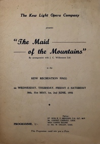
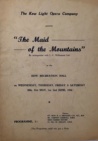
Programme - Theatre Programme, The Maid of the Mountains / by Harold Fraser-Simson, 1956
The Kew Light Opera Company was formed in 1952. Its first production, held in the Kew Recreation Hall was Leslie Stuart's Florodora. In 1957, the Company was subsumed in the "Q" Theatre Guild.Arthur Henry Dear was an employee of the City of Kew, acting as Hall Keeper of the Kew Recreation Hall in Wellington Street, and later the new Kew City Hall in Cotham Road. The Arthur Dear Collection contains memorabilia - tickets, programmes, invitations - as well as his identification badge. Items in the collection dates from the 1940s to the 1960s. The Kew Recreation Hall (Wellington Street) and later the Kew City Hall (Cotham Road) were major locations in suburban Melbourne in the postwar period for civic and private events including theatre productions and exhibitions. The Arthur Dear Collection (in conjunction with the scrapbooks compiled by Marion Tilley) provide a comprehensive snapshot of performing arts in Kew during the 1940s, 1950s and 1960s. The collection includes valuable data about performances, performers, directors etc., during this period. Theatre programme for a production of The Maid of the Mountains in the Kew Recreation Hall by the Kew Light Opera Company. The 4-page programme includes a cast list and a synopsis. the maid of the mountains, harold fraser-simson, arthur dear collection, performing arts -- kew -- victoria, kew recreation hall -- wellington street, kew civic hall -- cotham road, city of kew, theatre memorabilia -
 Kew Historical Society Inc
Programme - Theatre Programme, The Maid of the Mountains / by Harold Fraser-Simson, 1956
The Kew Light Opera Company was formed in 1952. Its first production, held in the Kew Recreation Hall was Leslie Stuart's Florodora. In 1957, the Company was subsumed in the "Q" Theatre Guild.Arthur Henry Dear was an employee of the City of Kew, acting as Hall Keeper of the Kew Recreation Hall in Wellington Street, and later the new Kew City Hall in Cotham Road. The Arthur Dear Collection contains memorabilia - tickets, programmes, invitations - as well as his identification badge. Items in the collection dates from the 1940s to the 1960s. The Kew Recreation Hall (Wellington Street) and later the Kew City Hall (Cotham Road) were major locations in suburban Melbourne in the postwar period for civic and private events including theatre productions and exhibitions. The Arthur Dear Collection (in conjunction with the scrapbooks compiled by Marion Tilley) provide a comprehensive snapshot of performing arts in Kew during the 1940s, 1950s and 1960s. The collection includes valuable data about performances, performers, directors etc., during this period. Theatre programme for a production of The Maid of the Mountains in the Kew Recreation Hall by the Kew Light Opera Company. The 4-page programme includes a cast list and a synopsis. arthur dear collection, kew light opera company, kew recreation hall, theatre - victoria, theatre - kew, the maid of the mountains, harold fraser-simson -
 Kew Historical Society Inc
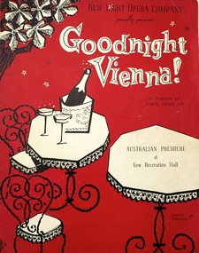
Programme - Theatre Programme, Goodnight Vienna! / by George Posford, 1956
The Kew Light Opera Company was formed in 1952. Its first production, held in the Kew Recreation Hall was Leslie Stuart's Florodora. In 1957, the Company was subsumed in the "Q" Theatre Guild.Arthur Henry Dear was an employee of the City of Kew, acting as Hall Keeper of the Kew Recreation Hall in Wellington Street, and later the new Kew City Hall in Cotham Road. The Arthur Dear Collection contains memorabilia - tickets, programmes, invitations - as well as his identification badge. Items in the collection dates from the 1940s to the 1960s. The Kew Recreation Hall (Wellington Street) and later the Kew City Hall (Cotham Road) were major locations in suburban Melbourne in the postwar period for civic and private events including theatre productions and exhibitions. The Arthur Dear Collection (in conjunction with the scrapbooks compiled by Marion Tilley) provide a comprehensive snapshot of performing arts in Kew during the 1940s, 1950s and 1960s. The collection includes valuable data about performances, performers, directors etc., during this period. Theatre programme for the Australian premiere of Goodnight Vienna! in the Kew Recreation Hall by the Kew Light Opera Company. The 12-page programme includes profiles, a cast list, a musical synopsis, and advertisements. goodnight vienna!, george posford, arthur dear collection, performing arts -- kew -- victoria, kew recreation hall -- wellington street, city of kew, theatre memorabilia -
 Kew Historical Society Inc
Programme - Concert Programme, Chamber Music Concert / by Kew Philharmonic Society, Undated
The Kew Philharmonic Society was founded by Dr. Ehrenfeld, c.1946, who was also the Orchestra's first conductor. He was succeeded by Harold Badger in 1954 following the death of the former. During the 1940s and 1950s, the Orchestra played its concerts in the Kew Recreation Hall in Wellington Street. In 1960, the Orchestra relocated to the new Kew City Hall in Cotham Road (the site of the current Kew Library).Arthur Henry Dear was an employee of the City of Kew, acting as Hall Keeper of the Kew Recreation Hall in Wellington Street, and later the new Kew City Hall in Cotham Road. The Arthur Dear Collection contains memorabilia - tickets, programmes, invitations - as well as his identification badge. Items in the collection dates from the 1940s to the 1960s. The Kew Recreation Hall (Wellington Street) and later the Kew City Hall (Cotham Road) were major locations in suburban Melbourne in the postwar period for civic and private events including theatre productions and exhibitions. The Arthur Dear Collection (in conjunction with the scrapbooks compiled by Marion Tilley) provide a comprehensive snapshot of performing arts in Kew during the 1940s, 1950s and 1960s. The collection includes valuable data about performances, performers, directors etc., during this period. Music programme for a Chamber Music Concert by the Kew Philharmonic Society, presented in the Kew Recreation Hall. kew philharmonic society, arthur dear collection, performing arts -- kew -- victoria, kew recreation hall -- wellington street -
![Kew Philharmonic Society [Subscriptions]](/media/collectors/550653872162f11fb04854aa/items/58fbe9add0ce631fe4fb5b01/item-media/58fcab0bd0ce1421306161d9/item-fit-380x285.jpg) Kew Historical Society Inc
Kew Historical Society IncDocument, Kew Philharmonic Society [Subscriptions], Undated
The Kew Philharmonic Society was founded by Dr. Ehrenfeld, c.1946, who was also the Orchestra's first conductor. He was succeeded by Harold Badger in 1954 following the death of the former. During the 1940s and 1950s, the Orchestra played its concerts in the Kew Recreation Hall in Wellington Street. In 1960, the Orchestra relocated to the new Kew City Hall in Cotham Road (the site of the current Kew Library).Arthur Henry Dear was an employee of the City of Kew, acting as Hall Keeper of the Kew Recreation Hall in Wellington Street, and later the new Kew City Hall in Cotham Road. The Arthur Dear Collection contains memorabilia - tickets, programmes, invitations - as well as his identification badge. Items in the collection dates from the 1940s to the 1960s. The Kew Recreation Hall (Wellington Street) and later the Kew City Hall (Cotham Road) were major locations in suburban Melbourne in the postwar period for civic and private events including theatre productions and exhibitions. The Arthur Dear Collection (in conjunction with the scrapbooks compiled by Marion Tilley) provide a comprehensive snapshot of performing arts in Kew during the 1940s, 1950s and 1960s. The collection includes valuable data about performances, performers, directors etc., during this period. A form outlining how subscriptions can be made for the Kew Philharmonic Society. The undated note states that the Society has three concerts per year. It is noted that rehearsals are held in the Kew Music Centre, Beresford Street, Kew. The form includes details of entitlements for ticket holders and annual fees.kew philharmonic society, arthur dear collection, performing arts -- kew -- victoria, kew recreation hall -- wellington street, theatre memorabilia -
 Kew Historical Society Inc
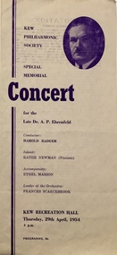
Programme - Concert Programme, Special Memorial Concert / Kew Philharmonic Society, 1954
The Kew Philharmonic Society was founded by Dr. Ehrenfeld, c.1946, who was also the Orchestra's first conductor. He was succeeded by Harold Badger in 1954 following the death of the former. During the 1940s and 1950s, the Orchestra played its concerts in the Kew Recreation Hall in Wellington Street. In 1960, the Orchestra relocated to the new Kew City Hall in Cotham Road (the site of the current Kew Library).Arthur Henry Dear was an employee of the City of Kew, acting as Hall Keeper of the Kew Recreation Hall in Wellington Street, and later the new Kew City Hall in Cotham Road. The Arthur Dear Collection contains memorabilia - tickets, programmes, invitations - as well as his identification badge. Items in the collection dates from the 1940s to the 1960s. The Kew Recreation Hall (Wellington Street) and later the Kew City Hall (Cotham Road) were major locations in suburban Melbourne in the postwar period for civic and private events including theatre productions and exhibitions. The Arthur Dear Collection (in conjunction with the scrapbooks compiled by Marion Tilley) provide a comprehensive snapshot of performing arts in Kew during the 1940s, 1950s and 1960s. The collection includes valuable data about performances, performers, directors etc., during this period. Special Memorial Concert programme honouring the founder of the Orchestra, the late Dr. A.P. Ehrenfeld.arthur dear collection, kew philharmonic society, music - victoria, music - kew, kew recreation hall, concert programme, a. p. ehrenfeld