Showing 384 items
matching town water
-
 Bayside Gallery - Bayside City Council Art & Heritage Collection
Map - print, Melbourne and Metropolitan Board of Works, Interim development order: Brighton, Moorabbin and Sandringham, 1959
The Melbourne and Metropolitan Board of Works (now Melbourne Water) was established in 1891. From that time, as part of their work laying water and sewerage connections, they created detailed plans of houses and other buildings in the Melbourne metropolitan area. In 1956 it acquired powers to construct and maintain highways and bridges, protect and improve the foreshores and create and maintain parks within the metropolitan region. This Interim development order comprises part of the municipalities of Brighton, Moorabbin and Sandringham and was made on 20 October 1959.brighton, moorabbin, sandringham, melbourne and metropolitan board of works, map, town planning, cartographic material, interim development order, bayside -
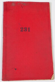 Bendigo Historical Society Inc.
Administrative record - Work Book
The item is a soft cover book recording daily work of T.J. Connolly, Ironmongers, Sandhurst. Each handwritten page is dated at the top and records the customer surname, goods supplied, price of items and total price. In most entries, a town or area is included after the customer's name. Each page has been wavy lines added over each customer entry. The red soft cover has a decorative inlay both front and back with some wearing at the corners. The number "231" is stamped directly on the front cover. The pages are bound together with string. The book includes the date range of 25 February 1897 to 24 May 1897. All pages have been used. This item is part of the Margaret Roberts Collection.At crossed tick has been added to the front cover to the left of the "231" stamp. A line of ink sits under some water marks at the top of the front cover. Drops of ink sit in the decorative inlay at the bottom left-hand side of the front cover and over the back cover also.margaret roberts collection, ironmongers, forest street, bendigo businesses -
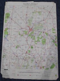 Bendigo Historical Society Inc.
Map - Bush Fire Control Map Bendigo District
A Bush Fire Control map is a valuable tool used by emergency services and communities to respond to respond to bushfires.Cream coloured parchment map showing roads, railway lines, telephone lines, rivers, creeks and water courses. Also marked are houses, Post Offices, Police stations, bush fire brigades, water channels, swamps, marshes, dense, medium and scattered timber, aqueducts and reservoirs. Villages, districts and Towns are clearly marked. Printed in red, green, black and blue. Very clear and easy to read. Undated.bush fires, bendigo area map -
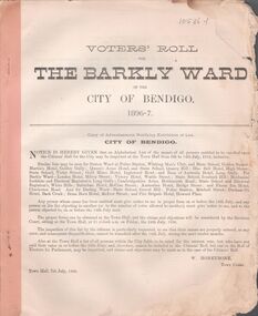 Bendigo Historical Society Inc.
Booklet - Voters Rolls
Eighteen printed paper voters rolls for The Barkly Ward 1896 - 1912 and 1914. One supplementary voters list, undated. Voters lists are stapled together, and each have water marks, various ragged edges, folds and tearing to the pages. Printed by various printers of Bendigo. W.Honeybone is the Town Clerk. The one supplementary voters list is a single printed page, printed only on one side, with ragged edges and tears.voters roll, city of bendigo, w.honeybone, town hall, barkly ward -
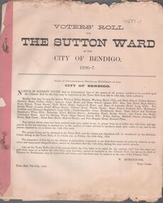 Bendigo Historical Society Inc.
Booklet - Voters Rolls
Nineteen printed paper voters rolls for The Sutton Ward 1896 - 1912 and 1914. One supplementary voters list, undated. Voters rolls are stapled together, and each have water marks, various ragged edges, folds and tearing to the pages. Printed by various printers of Bendigo. W.Honeybone is the Town Clerk. The one supplementary voters list is a single printed page, printed only on one side, with ragged edges and tears.voters roll, city of bendigo, w.honeybone, town hall, sutton ward -
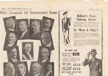 Ballarat Tramway Museum
Newspaper, The Courier Ballarat, Courier, 8/3/1938 p21, 22, 29 & 30 - photo of Sturt St, Mar. 1938
Yields information about Ballarat and its locations or environs late 1938.Pages 21,22,29 and 30 of the Centenary issue of the Ballarat Courier, 8/3/1938. Page 21 "When the World was Wide", photos, Ballaarat City Council of Centenary of settlement in the Ballarat district, year, and Sturt St. from Bridge St., possibly original photo of time. Ads. - Marks & Phillips, - Tailors and C.J.Coles. Page 22 - Towns that have a history - Learmonth, Clunes, Creswick and Buninyong. Photos - Learmonth, Clunes and Forestry school Creswick. Ads - State Savings Bank of Vic, Swanston Used Cars. Page 29 - Ballarat's historic Sports Grounds - origin and development, Eastern Oval incident, listing of nuggets found and quartz specimens. Ads for Prestige stockings, T&G Mutual Life and Fosters Lager. Photo of mine at No. 6 shaft on Band of Hope and Albion Consolidated. Page 30 - articles - Ballarat's sporting origins and swamp to reservoir (water supply). Photos of First England Cricket team to visit Ballarat and aqueduct at Kirks storage basin. Ads for Craig Bros, Pratts cash stores, Haymes paints and Ballarat Block Arcade - shops. Record reviewed and images of some of the pages added 10-9-2013trams, tramways, ballarat centenary celebrations, centenary, sports ground, water supply -
 Buninyong & District Historical Society
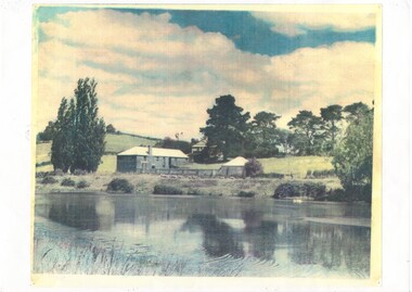
Photograph - B/W photograph, Mrs. Bon Strange (nee Lorensini), Old Brewery and Gong Reservoir Buninyong, c 1935, c1935
Early gold-rush building, originally Brewery, next to Gong Reservoir (early water source for township). Building since converted to residence.Record of early building as of mid 1930'sLaser copy of hand-tinted photograph of Old Brewery and Gong Reservoir Buninyong, c 1935, fields rising behind, tall treees, partially obscured house.building, buninyong, brewery, industry, landscape -
 Buninyong & District Historical Society
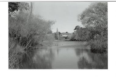
Photograph - B/W photograph, View of The Gong, old Brewery in the background, September 1993
The Gong has been part of the Buninyong industrial, cultural and recreational history pre and post 1837Fed by springs, the Gong has been a major source of water for industrial, pastoral, recreational uses and local wildlifeBlack and white photograph of the Gong, view of the South East Corner with the Old Brewery in the backgroundbotanic gardens, brewery, landscape, industry, water supply, springs -
 Buninyong & District Historical Society
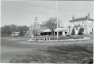
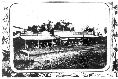
Photograph - Original B/W photograph, Mr Clive Brooks, Streetscape of Learmonth St., Buninyong, looking over roundabout to Town Hall and businesses, 18th September 1993
Part of a photographic record of Buninyong township. The buildings range from 1960s back to 1896, 1887, 1866, to a remnant of 1855, hidden within the shop of D. Brown electrician, consequently reflecting much alteration and change when compared to earlier photos.The streetscape is of historic significance, recording the detail of the streetscape in 1993. Many of the buildings have since undergone significant renovation/change.Streetscape of Learmonth St., Buninyong, looking over roundabout to Town Hall and businesses. Elm trees in the grounds of the Uniting (formerly Presbyterian) Church are seen in the background. Buildings are the fire station, council offices, Town Hall, Whykes Butchers, M. & D. Brown electrician, Buninyong Cake Shop and former bank, now a residence. Oak trees are in front of the council offices and shire hall. One tree planted in 1959 to mark the occasion of the connection of a water supply to Buninyong. A variety of elm is at the end of the row outside the Bank, now a residence. Junipers on each side of the former bank door was planted c1970.learmonth st, buninyong, bank, cake shop, m & d brown, electrician, whykes butchers, whykes, town hall, council offices, fire station -
 Buninyong & District Historical Society
Photograph - B/W photograph, View of the Gong, April 1994
The Gong has been part of the Buninyong industrial, cultural and recreational history pre and post 1837Fed by springs, the Gong has been a major source of water for industrial, pastoral, recreational uses and local wildlifeBlack and white photograph of the Gong, view from Scott Street to the South West cornerbotanic gardens, landscape, industry, water supply, springs -
 Kew Historical Society Inc
Book, Stories They Tell : A history of Kew through objects, 2022
'Stories They Tell : A history of Kew through objects' explores diverse narratives from European settlement to the first decades of the twenty-first century. These stories use as their starting point artworks, texts and artefacts from the nationally significant collection of the Kew Historical Society. Limited to 100 copies.117 pp : illustrated : Appendices Chapters: Preface / Robert Baker p4. The collection / Robert Baker p5. Cartwheel penny / Robert Baker p6. Creek and old watering stage / David White p10. John Carson: Mayor 1863–4 1 / Julie King p4. Wedding dress / Suzanne McWha p18. Back to Kew 1875 / Judith Scurfield p22. Barnard’s clock / Margaret Robinson p26. Denbigh quilt / Suzanne McWha p28. Fragments of art decoration / Robert Baker p32. Mr Richardson’s sock / Felicity Renowden p36. Kew Volunteer Fire Brigade / David White p38. Kew Where We Live / Judith Scurfield p42. [MMBW} Detail Plan No. 1580 / Judith Scurfield p46. Adeney Avenue / Suzanne McWha p50. Young Workers’ Patriotic Guild / Margaret Robinson p54. Roll of Honor [Thomas Rand] / Robert Baker p56. Alice Anderson in her tourer / Felicity Renowden p60. Kew War Memorial / David White p62. Beaded dance dress / Suzanne McWha p 66. The great flood of 1934 / Desley Reid p68. Depression-era toolbox / Robert Baker p72. War Savings Street / Julie King p74. Kew Public L.ibrary / Suzanne McWha p78. Signature supper cloth / Desley Reid p82. View from the garden of Rockingham / Desley Reid p86. Cr Marie Dalley / Felicity Renowden p90. Centenary of Kew / Robert Baker p94. Doris Dickinson’s gown / Julie King p98. [Model Dairy] Milk bottles / Robert Baker p100. Kew Civic Centre / David White p102. Bicentennial tapestries / Margaret Robinson p106. Crest of the City of Kew / Desley Reid p110. Town Crier [outfit] / Desley Reid p112. Acknowledgements p114. List of works p115.non-fiction'Stories They Tell : A history of Kew through objects' explores diverse narratives from European settlement to the first decades of the twenty-first century. These stories use as their starting point artworks, texts and artefacts from the nationally significant collection of the Kew Historical Society. Limited to 100 copies.collection -- kew historical society, museum catalogues, henty family, cartwheel pennies, kew lunatic asylum, patchwork quilts, john carson, george bouchier richardson, gb richardson, coombs family, james dannock, back to kew 1875, francis barnard, denbigh family, cullis hill & co, ordsall, southesk, kew volunteer fire brigade, jfc farquhar, henry kellett, mmbw detail plan 1580, william nicholls anderson, young workers patriotic guild, roll of honor -- town of kew, alice anderson, kew war memorial, flapper dresses, fairfield bridge, chandler highway bridge, warren trestrail, furniture -- 1930s, war savings streets, kew library, children's libraries, voluntary aid detachments - kew (vic.), rockingham, james govett, centenary of kew, mayoresses -- kew (vic.), model dairy -- kew (vic.), doris dickinson, crests -- city of kew (vic.), town criers -- kew (vic.), joy stewart, australian bicentennial -- kew (vic.), kew civic centre, ak lines mcfarlane marshall, adeney avenue -- kew, wwi -
![View of the Township of Ballan / [by] Nicholas Caire, circa 1876](/media/collectors/550653872162f11fb04854aa/items/578258d3d0cdd1176ce23812/item-media/57825939d0cdd1176ce27694/item-fit-380x285.jpg) Kew Historical Society Inc
Kew Historical Society IncPhotograph, Anglo-Australasian Photographic Company, View of the Township of Ballan, c. 1876
Nicholas Caire was born on Guernsey in the Channel Islands in 1837. He arrived in Adelaide with his parents in about 1860. In 1867, following photographic journeys in Gippsland, he opened a studio in Adelaide. From 1870 to 1876 he lived and worked in Talbot in Central Victoria. In 1876 he purchased T. F. Chuck's studios in the Royal Arcade Melbourne. In 1885, following the introduction of dry plate photography, he began a series of landscape series, which were commercially successful. As a photographer, he travelled extensively through Victoria, photographing places few of his contemporaries had previously seen. He died in 1918. Reference: Jack Cato, 'Caire, Nicholas John (1837–1918)', Australian Dictionary of Biography.An original, rare photograph from the series 'Views of Victoria: General Series' by the photographer, Nicholas Caire (1837-1918). The series of 60 photographs that comprise the series was issued c. 1876 and reinforced a neo-Romantic view of the Australian landscape to which a growing nationalist movement would respond. Nicholas Caire was active as a photographer in Australia from 1858 until his death in 1918. His vision of the Australian bush and pioneer life had a counterpart in the works of Henry Lawson and other nationalist poets, authors and painters.‘View of the Township of Ballan’.; Views of Victoria (General Series) No.35; Albumen silver photograph | Photo on card with Title and Description on reverse | Mounted 24 x 30 cm; Photo 12 x 17 cm.On Reverse: ‘The Township of Ballan is situated near the Bullarook Forest, and is distant about twenty miles from Ballarat. It is chiefly a small agricultural town, but it has become notable of late owing to its Mineral Springs, of which there are several in the neighbourhood. The most important one is owned by Messrs. Joske & Co., who supply the public with this delightful beverage.’ nicholas caire (1837-1918), ballan, bullarook forest, mineral water, ballan mineral springs, post and rail fence -
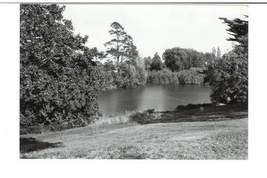
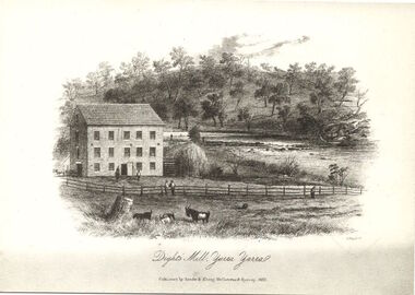 Kew Historical Society Inc
Print, Dight's Mill, Yarra Yarra
"In 1839 John Dight purchased Melbourne block 88, which included 26 acres of land along the Yarra River for £481 at the Port Phillip land sales held in Sydney. Dight was already in the business of flour milling and had a mill near Campbell Town in New South Wales called ‘Ceres’. In April 1840, he notified his customers through The Sydney Herald that he was leaving to go to Port Phillip. The first steam powered flour mill was constructed in Melbourne in 1841. Dight built his water powered mill, soon after, from bricks bought over from Tasmania. Dight used the river to power his mill: Water flowed along an inlet channel to turn an undershot water wheel. In order to regulate flow or to ensure flow for times when river levels were low, Dight constructed a rough stone weir. " (https://www.melbournewater.com.au/whatwedo/projectsaroundmelbourne/Documents/A_Short_History_of_Dights_Falls_Fact_Sheet.pdf) This work forms part of the collection assembled by the historian Dorothy Rogers, that was donated to the Kew Historical Society by her son John Rogers in 2015. The manuscripts, photographs, maps, and documents were sourced by her from both family and local collections or produced as references for her print publications. Many were directly used by Rogers in writing ‘Lovely Old Homes of Kew’ (1961) and 'A History of Kew' (1973), or the numerous articles on local history that she produced for suburban newspapers. Most of the photographs in the collection include detailed annotations in her hand. The Rogers Collection provides a comprehensive insight into the working habits of a historian in the 1960s and 1970s. Together it forms the largest privately-donated collection within the archives of the Kew Historical Society.An engraving of Dight's Mill on the Yarra. The image was originally published in Sands & Kenny, Melbourne & Sydney. Dorothy Rogers reproduced the print in 'A History of Kew' (1973). It faces page 8.Published by Sands & Kenny, Melbourne & Sydney, 1856dight's mill, dorothy rogers, dight's falls, yarra river, kew, john dight -
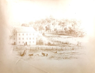 Kew Historical Society Inc
Print, Sands & Kenny, Dights Mill, 1856
"In 1839 John Dight purchased Melbourne block 88, which included 26 acres of land along the Yarra River for £481 at the Port Phillip land sales held in Sydney. Dight was already in the business of flour milling and had a mill near Campbell Town in New South Wales called ‘Ceres’. In April 1840, he notified his customers through The Sydney Herald that he was leaving to go to Port Phillip. The first steam powered flour mill was constructed in Melbourne in 1841. Dight built his water powered mill, soon after, from bricks bought over from Tasmania. Dight used the river to power his mill: Water flowed along an inlet channel to turn an undershot water wheel. In order to regulate flow or to ensure flow for times when river levels were low, Dight constructed a rough stone weir." (Melbourne Water)Dights Mill. Reproduction of a book plate from an original wood engraving, showing Dights Mill and Falls on the River Yarra. The image was originally published in Sands & Kenny, Melbourne & Sydney.Annotation on reverse: "Dights Flour".dights mill, yarra river -
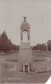 Sunbury Family History and Heritage Society Inc.
Photograph, C1916
Joseph Starkie was the Chairman of the Sunbury Waterworks Trust from 1905 to 1913. During that time he was instrumental in getting a permanent water supply installed for the town of Sunbury. After his death in April 1913, the townspeople erected a memorial which stood at the intersection of Brook and Stawell Street. It was unveiled on 26 January 1915 by Terence O'Brien. The original memorial included a drinking fountain and horse trough. As traffic increased within the town, the centre section of the fountain, without the horse trough, was resited in a reserve opposite the Memorial Hall. The photograph shows the monument on its original site. The installation of a reliable and permanent water supply for Sunbury was an important achievement for the town in the early years of the twentieth century.A sepia photograph in post card format of a water fountain and trough in a street in front of an avenue of trees.J. D. STARKIE MEMORIALstarkie, joseph daniel., water fountain, j.d.starkie memorial -
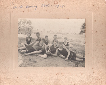 Sunbury Family History and Heritage Society Inc.
Photograph, Sunbury Swimming Club
The photograph was taken of swimmers at the water hole at The Nook in Sunbury in 1917. The pool at The Nook was the town's only swimming area from 1916 to 1966, when an Olympic size swimming pool was built in Ligar Street.A non-digital sepia photograph mounted on cream board of eight young men sitting on a grassy area and dressed in swimwear c1917.sunbury swimming club, the nook, swimming, sports -
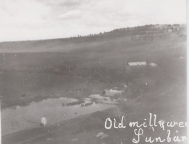 Sunbury Family History and Heritage Society Inc.
Photograph
The former mill and weir shown in the photograph were sited on the banks of Jacksons Creek downstream from the town of Sunbury. John Eadie, a Scottish immigrant established the water-driven flour mill on the banks of the creek after he arrived in the colony in 1866. The mill continued operating until the outbreak of World War 1 when the metal wheel and iron roofing were taken and used for the war effort. The hill in the back ground with the trees and buildings was the site of the former Sunbury Asylum. Milling was one of Sunbury's early industries that were established in the district.A black and white photograph of a building and a lake in a valley. Buildings and trees are visible on a distant hillside.sunbury flour mill., milling -
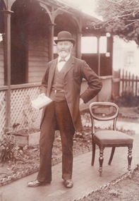 Sunbury Family History and Heritage Society Inc.
Photograph, c1900s
... to honour the arrival of the permanent water supply to the town. ... the arrival of the permanent water supply to the town ...The man photograph in a garden is Joseph David Starkie, who was a Bulla Shire councillor for more than twenty years and during that time he was elected Shire President four times. He was also a member of the Sunbury Waterworks Trust and served as the chairman from 1905 - 1908. While serving on the water board he was instrumental in Sunbury gaining a permanent water supply. A drinking fountain has been erected on a reserve at the Village Green to honour the arrival of the permanent water supply to the town. The installation of a permanent water supply benefitted the town and contributed to a more reliable rail service as steam trains refilled their tanks with water at Sunbury Station. Prior to this the water was transported by horse and cart from nearby Jacksons Creek.A sepia photograph of a well-dressed man who is holding a book and is standing in a front garden of a weatherboard house.starkie, joseph daniel. -
 Monbulk Historical Society
Ben Simcox
Bennie Simcox first came to the Monbulk area about 1860, following the first important gold discovery at the end of 1858. As the gold rush was short lived Simcox returned to Collingwood but later came back to Monbulk, built himself a hut to live in and become its first known permanent resident. The hut was burnt in the 1913 fires. Monbulk was thrown open to selection in 1894, and that's when the first farmers including Bennie Simcox went into Monbulk. It was a big, timbered country in those days. Once Ben had cleared some of his land he started to grow raspberries on it. He would be up before daylight ready to start picking. Ben also picked for a local family, the Camms to help make ends meet. When Ben Simcox was virtually at the retired stage, he wanted to develop his bit of the gully as a tourist attraction, As his nephew Fred Gay who owned the 10 acres below Ben wanted to farm, he was happy to swap his treed block with Ben. At a time when most settlers were clearing their properties, Ben Simcox, by contrast, cultivated the native plants and planted most of the large trees seen on the property today. And so Nathania Springs was developed as a tourist resort, and a mini-botanical garden. He diverted the natural water supply to form ornamental garden pools stocked with trout and tame native black fish. There were many visitors came to the Dandenongs, Some arriving in motor cars others in converted furniture vans lined with seats or charabancs with the long extended chassis and the open canvas roofs. Identities such as Billy Hughes, Madame Melba would often come to look through Nathania Springs. Bennie sold Nathania Springs to Councillor Ferdinand Thomas Le Juge, a boarding house proprietor and later the town baker in 1909 then in about 1921 Ben’s nephew Fred and his wife and family continued to open Nathania Springs to the public. It was not unusual in around 1924-25 for up to a thousand people a day to arrive at Nathania Springs to go through the gardens. At sixpence a time, that was a lot of money in those days. This photo is part of a collection of historic and social significance of the early settlement of Monbulk. Copies of photographs can be purchased from the Monbulk Historical Society.simcox, nathania springs, monbulk, 1860, berries -
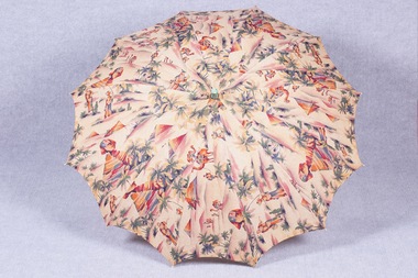 Brighton Historical Society
Accessory - Parasol, 1920s
Printed with colourful pyramids, palm trees and camels, this parasol tells a story of the changing society of the 1920s, the growth of the Art Deco movement and a wave of Egyptomania sparked by the discovery of Tutankhamun’s tomb. Parasols such as this one were used by holidaymakers on Brighton Beach, by this time a popular seaside destination.Parasol with a cotton canopy printed with an Egyptian-inspired design of the Sphinx, camels, palm trees and water carriers. Painted handle with plaited cotton tassel with pink wooden bead.parasol, 1920s, egyptomania -
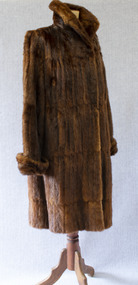 Brighton Historical Society
Clothing - Coat, Water rat fur coat, c.1930s
This coat belonged to Brighton resident Audrey Winifred Pickett (nee Heriot; 1915-2011). The coat is made from the pelts of rakali, also known as the Australian water rat, a native rodent species similar to an otter. Growing up to 35 centimetres in length, rakali typically live in burrows near water, feeding on fish, insects, yabbies and waterbirds. Throughout the early twentieth century, they were widely considered to be a nuisance and were hunted for their soft and waterproof fur. Demand for rakali pelts increased during the 1930s Depression years, when a ban was placed on the import of overseas furs; rakali fur became a popular substitute for the fur of the American muskrat. The species was placed under a protection order in 1938, although periodic culls were allowed until 1957 due to their perceived destruction of irrigation banks and fishing nets. Audrey recalled that the coat was made for her by furrier F. J. Ellemor after a large cull of rakali. The coat was displayed in the window of Ellemor's Block Place store. F. J. Ellemor Pty Ltd was established in 1908 by furrier Francis John Ellemor (1867-1944) and continued into the late twentieth century under the management of his son Wilfred (1801-1972). Francis and his wife Edith lived in Rothesay Avenue, Brighton from the late 1930s.Three-quarter length brown fur coat made of Australian water-rat (rakali) pelts. Wide raised collar and cuffs. Fastens centre front with two large hooks and eyes. Lined with chocolate brown silk satin.Label, woven brown on beige silk, centre back neck: created by / F. J. Ellemor / FURRIERS / MELBOURNEfur coat, rakali, australian water rat, melbourne fashion, audrey winifred heriot, audrey winifred pickett, audrey winifred north, francis john ellemor, f. j. ellemor, furrier -
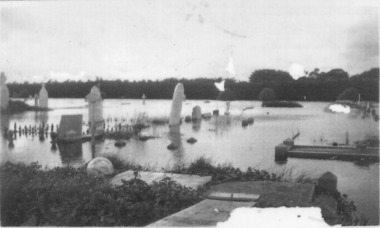 Port Fairy Historical Society Museum and Archives
Photograph
1946 was the year of the biggest flood experienced in Port Fairy. This photograph shows evidence of the inundation at the Port Fairy Cemetery situated at the West of the townBlack and white photograph of headstones surrounded by waterflood, river, 1946, headstone -
 National Communication Museum
Photograph (item) - Floodwater pole repair, Sydney Press, June 1952
Postmaster-General's Department telegraph linesman, Chris Byrnes, received a British Empire Medal for bravery and devotion to duty for his response to the flooding at Darlington Point, New South Wales, in June 1952. As E Henderson, then Acting Director of Posts and Telegraphs recalled, the town's "communication lines were menaced by floodwaters" when the nearby Murrumbidgee River flooded. In order to retain communication to the town, Chris Byrnes, a Postmaster-General's Department employee of over 13 years, acted in the "best traditions of the service" (E Henderson). An eye witness, recorded in the Murrumbidgee Irrigator newspaper on June 27 1952, described Byrne’s efforts: "An interesting incident was witnessed when a Leeton post office linesman swam through flood waters to reach a telegraph post which had been washed out by the flood…With a rope tied around his waist, one end of which was held by other members of the linesmen's gang, Chris Byrne swam through the flood water…to release the trunk lines from the post." An eye witness, recorded in the Murrumbidgee Irrigator newspaper on June 27 1952, described Byrne’s efforts: "An interesting incident was witnessed when a Leeton post office linesman swam through flood waters to reach a telegraph post which had been washed out by the flood…With a rope tied around his waist, one end of which was held by other members of the linesmen's gang, Chris Byrne swam through the flood water…to release the trunk lines from the post."darlington point, murrumbidgee river, pmg, postmaster-general, linesman, flooding, natural disaster, emergency -
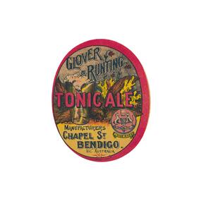 City of Greater Bendigo - Civic Collection
Artwork, other - Label, Harry Tulloch, Glover & Runting, c 1910
In an era when drinking beer was considered safer than drinking water, pubs were prolific and the centre of social and commercial life in Bendigo. (Bridgfoot,J. Taverns to Temperance: Pubs in Bendigo). While the Cohn Brothers and their 'tied hotels' and were one of the most successful brewers in the district, many smaller brewers also existed and the industry was a major source of employment. C.J. Glover or Charles Runting appear to have been in one of those.Oval beer bottle label. Multi coloured print featuring images of hops, a glass of ail, the Bendigo Coat of Arms and various font styles.Glover & Runting / Tonic Ale / Manufacturers / Chapel St / Bendigo / Vic Australiamaking a nation, city of bendigo commerce -
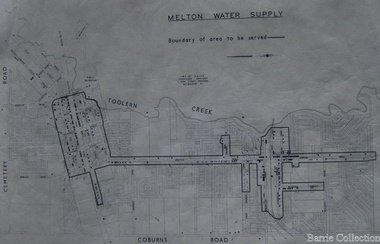 Melton City Libraries
Map, Melton Water Supply, Unknown
... the boundary of the area where the water will be serviced in the town ...The development that had arguably the greatest impact in encouraging population growth in the shire during this period, was the establishment of a reliable water supply for the district. This had been a major concern of the local community for over 100 years, since the Melton township was first founded. Despite various schemes over the years to create a reliable water supply, the district was still dependent on bores, wells and tanks when the Melton Waterworks Trust was established in 1961 to address Melton’s water woes. With the opening of the Djerriwarrh Dam in December 1963, the shire’s residents finally had access to a reticulated water supply.Map shows the boundary of the area where the water will be serviced in the towncouncil -
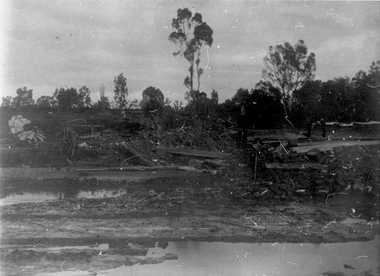 Tarnagulla History Archive
Photograph: Debris after flood, Newbridge, Debris after flood, Newbridge, 1909 (original image)
On 20th August, 1909 the Laanecoorie Weir broke away and released 18.3 million cubic metres of water through the opening and causing severe damage to all towns downstream. At Newbridge, Petersen's bakery collapsed and Simpson's Store and Hotel flooded to the roof. The billiard table was later found in a tree five miles down the Loddon near Learmonth. Murray Comrie Collection. Monochrome photograph, image depicting debris in the area near Loddon River at Newbridge after major flood in 1909. This is a very dark copy of an older original. Copy probably made by Murray Comrie in the 1960s.newbridge, loddon river, flood -
 Tarnagulla History Archive
Photograph: Simpsons Store and Hotel, Newbridge after flood, Simpsons Store and Hotel, Newbridge after flood, 1909 (original image)
In this image, store merchandise, including drapery, is hung out to dry after the flood. On 20th August,1909 the Laanecoorie Weir broke away and released 18.3 million cubic metres of water through the opening and causing severe damage to all towns downstream. At Newbridge, Petersen's bakery collapsed and Simpson's Store and Hotel flooded to the roof. The billiard table was later found in a tree five miles down the Loddon near Learmonth. Murray Comrie Collection. Monochrome photograph, image depicting buildings in the area near Loddon River at Newbridge after major flood in 1909. This is a very grainy and dark copy of an older original. Copy probably made by Murray Comrie in the 1960s.newbridge, loddon river, flood, simpson, stores, hotels -
 Tarnagulla History Archive
Photographs: Loddon River, Newbridge after flood, Loddon River, Newbridge after flood, 1909 (original image)
On 20th August,1909 the Laanecoorie Weir broke away and released 18.3 million cubic metres of water through the opening and causing severe damage to all towns downstream. At Newbridge, Petersen's bakery collapsed and Simpson's Store and Hotel flooded to the roof. The billiard table was later found in a tree five miles down the Loddon near Learmonth. Murray Comrie Collection. Two copies of a monochrome photograph, image part of damaged bridge in the area near Loddon River at Newbridge after major flood in 1909. This is a very grainy and dark copy of an older original. Copy probably made by Murray Comrie in the 1960s.newbridge, loddon river, flood, bridge -
 Tarnagulla History Archive
Photographs: Loddon River, Newbridge after flood, Loddon River, Newbridge after flood, 1909 (original image)
On 20th August,1909 the Laanecoorie Weir broke away and released 18.3 million cubic metres of water through the opening and causing severe damage to all towns downstream. At Newbridge, Petersen's bakery collapsed and Simpson's Store and Hotel flooded to the roof. The billiard table was later found in a tree five miles down the Loddon near Learmonth. Murray Comrie Collection. Two copies of a monochrome photograph, image depicts the area near Loddon River at Newbridge after major flood in 1909. This is a very grainy and dark copy of an older original. Copy probably made by Murray Comrie in the 1960s.newbridge, loddon river, flood, bridge -
 Tarnagulla History Archive
Photographs: Loddon River, Newbridge after flood, Loddon River, Newbridge after flood, 1909 (original image)
On 20th August,1909 the Laanecoorie Weir broke away and released 18.3 million cubic metres of water through the opening and causing severe damage to all towns downstream. At Newbridge, Petersen's bakery collapsed and Simpson's Store and Hotel flooded to the roof. The billiard table was later found in a tree five miles down the Loddon near Learmonth. Murray Comrie Collection. Two copies of a monochrome photograph, image depicts the area near Loddon River at Newbridge after major flood in 1909. This is a very grainy and dark copy of an older original. Copy probably made by Murray Comrie in the 1960s.newbridge, loddon river, flood, bridge