Showing 455 items
matching victoria - development - history
-
 Southern Sherbrooke Historical Society Inc.
Book - Local History, Victorian Government Printing Office on behalf of the Government of Victoria, Historical Records Of Victoria, Vol. 3, 1984
pp.xix, 670, paperback book, maps, photos, colour plates, index. A collection of documents concerning the development of Melbourne, Victoria, Australia, compiled by the Public Records Office, Victoria.foundation of melbourne -
 Ballarat Tramway Museum
Document - Photocopy, M. Sayers, "Geelong Electric Tramways", 2000?
Photocopy of an article in the State Electricity Commission of Victoria Magazine, Contact, Vol 1, No. 3, Nov. 1936 titled "Geelong Electric Tramways". Two A4 sheets. The article gives a short history of the development of the Geelong tramway system, replacement of petrol buses, extensions to Belmont, Chilwell and North Geelong. Gives track construction details, track renewals from 1924 (concrete stringers replacement), trolley wire, power supply (550V DC), rolling stock, Birney trams, services, fares, passenger numbers and the new SEC green uniforms. Has a photo of the Geelong depot with senior staff named and a photo of a tramwayman in the new Green uniform. Trams 27,30, 5, 23 and 6. Record revised 3/4/2019 to add digital images with those from Andrew Cook CD. Andrew notes the person in the photo could be Mr. Percy.trams, tramways, sec, geelong, trackwork, uniforms, track repairs -
 Ballarat Tramway Museum
Document - Photocopy, M. Sayers, "The Development of Ballarat's Electricity Supply", 2000?
Photocopy of an article in the State Electricity Commission of Victoria Magazine, Contact, Vol 3, No. 2, Aug 1938 titled "The Development of Ballarat's Electricity Supply". Two A3 sheets. The item with six photographs details the history of the development of Ballarat's Power Supply. Details development of the initial power supply in Dana St, the take over by ESCo, DC power initially, expansion, introduction of AC in 1925 to Ballarat, the takeover by the SEC in 1934, changeover from DC to AC, expansion to outlying areas, Buninyong, Creswick etc. Gives description of installed plan, boilers, storerooms and the stores systems. Has photos of the Dana St. building, Ballarat A power station, Ljungstrom Turbo Alternator and three of the stores area. Record revised 3/4/2019 to add digital images with those from Andrew Cook CD. Each item had a thin strip of paper attached by staple to the top left hand corner, giving the Vol. No. details.On rear of 2nd A3 sheet in blue ink details of contact with the BTM by M. Sayers prior to sending the material.trams, tramways, sec, power supply, power station, ballarat a power station, esco -
 Bendigo Historical Society Inc.
Slide - DIGGERS & MINING. DIGGERS AND MINERS, c1850s
Diggers & Mining. Diggers and miners. The untold story of the gradual development of gold mining in Victoria is told in more detail in Unit 9. But at present we just need to notice the distinction between diggers and miners. There were gold diggings and goldmines during the gold era; in this unit of these filmstrips we are concerned only with life and work on the diggings. Markings: 32 994:LIF I. Used as a teaching aid.hanimounteducation, tertiary, goldfields -
 Bendigo Historical Society Inc.
Slide - DIGGERS & MINING. DIGGERS AND MINERS, c1850s
Diggers & Mining. Diggers and miners. From the middle 1850's on, there was a gradual development of gold mining in Victoria. (Remember that while the first stage of this, development was going on, tens of thousands of diggers were still working on old diggings, or rushing new fields. See earlier maps.) The first ''mines'' were small affairs, - - - Markings: 25 994:LIF I. Used as a teaching aid.hanimounteducation, tertiary, goldfields -
 Bendigo Historical Society Inc.
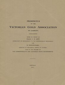
Document - MCCOLL, RANKIN AND STANISTREET COLLECTION: VICTORIAN GOLD ASSOCIATION, 1931
Prospectus of the Victorian Gold Association N.L. Based on a report by Messrs H. W. Gepp Consultant on Development to the Commonwealth Government and W. Baragwanath, Director of the Geological Survey of Victoria. Dated 1931 This company was formed to investigate the Deborah Mine, The Central Nell Gwynne Mine and the Monument Hill Mine. 12 pages including maps and Transverse Sections of the MinesThe Commonwealth and Victorian State Governments. E. Whitehead & Co., Pty., Ltd Printers 21 Equitale Place, Melbourne, C1.gold, mining, prospectus, bendigo, gold mines, victorian gold associatian, deborah mine, central nell gwynne mine, monument hill mine. -
 Bendigo Historical Society Inc.
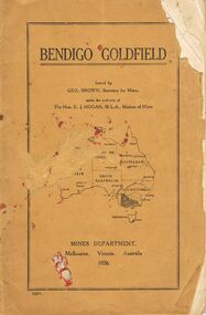
Book - JOAN O'SHEA COLLECTION: BENDIGO GOLDFIELD BOOK, 1936
Joan O'Shea collection. Buff coloured book issued by Mines Department Melbourne. Victoria Australia 1936. Information contained within refers to History, Recent developments and future Prospects, Geology, Lines of Reef for the Bendigo area, information regarding tonnage of gold and values of same at that time. The index at the rear of the book lists all of the mines in the Bendigo area.Geo. Brown, Secretary for Mines, Mines Departmentmining, business, mines department -
Bendigo Historical Society Inc.
Plan - SANDHURST BOYS CENTRE SITE PLANS: LISLE STREET UNITS
16 Working drawings including Floor Plans and Elevations Prepared by Michael DeVincentis, Architects; Wellington St Strathfieldsaye. October-November 1995. Scale 1:200. No 9538. Also Survey Plan for Lot 69D 3950 Sq m. Location unknown 16.02.2023.plan, bendigo, institutions, victoria. department of planning and development -
 Bendigo Historical Society Inc.
Document - PETER ELLIS COLLECTION: LETTER FROM BENDIGO FIELD NATURALISTS CLUB
Photocopy of an unsigned letter from The Bendigo Field Naturalists Club with copies sent to the Ministry for Conservation, Premier of Victoria, National Estate Dept, Forests Commission of Victoria, Conservation Council of Victoria, Loddon Campaspe Regional Authority, The Hon D McClure MLA, the Hon F S Grimwade MLC, F J Granter MLC, N B Reid MLC and J Bourchier MP. Letter refers to the Purchase of land of high conservation value within the Bendigo Whipstick area for consideration in the National Estate Program.communication, postal, letters, peter ellis collection, the bendigo field naturalists club, national estate funds, forests commission of vict, wallaby caves, mr ruedin, conservation council of victoria, national estate dept, whipstick interim development order, loddon campaspe regional authority, the hon d mcclure mla, the hon f s grimwade mlc, f j granter mlc, n b reid mlc, j bourchier mp -
 Bendigo Historical Society Inc.
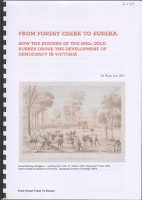
Booklet - From Forest Creek to Eureka, 2023
31-page spiral bound booklet by Pat Healy June 2023 'From Forest Creek to Eureka' How the Diggers of the 1850s Gold Rushes drove the developments of Democracy in Victoria. Includes colour images. Chapters include the Monster Meeting, Red Ribbon Movement in Bendigo, Eureka Stockade in Ballarat Published by Chewton Domain Society 2023gold rush, red ribbon agitation, eureka stockade -
 Bendigo Historical Society Inc.
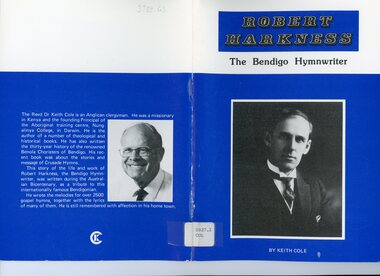
Book - LYDIA CHANCELLOR COLLECTION: ROBERT HARKNESS 'THE BENDIGO HYMWRITER', 1988
LYDIA CHANCELLOR COLLECTION: Robert Harkness 'The Bendigo Hymwriter' By Keith Cole. 1988 Published by Keith Cole Publications, 28 Woodbury Stree Victoria 3550, printed by D.G. Walker Pty Ltd Railway Place Bendigo Vic 3550 Contents: Godly Parents His early years and conversion Fourteen years with Charles M. Alexander Dedicated Service in the United States His musical development The Gospel Hymwriter Death and eulogybendigo, history, bendigo churches -
 Kew Historical Society Inc
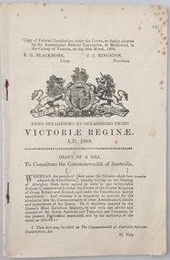
Document, Draft of a Bill to constitute the Commonwealth of Australia : copy of federal constitution under the Crown, as finally adopted by the Australasian Federal Convention at Melbourne, in the colony of Victoria on the 16th March, 1898, 1898
The Australasian Federation Conference met in Melbourne from 6-14 February, 1890. The National Australasian Convention, met in Sydney, from 2 March–9 April 1891. Debates about the draft Australasian Federal Convention of 1897/8 took place over three sessions: First session, Adelaide, 22 March – 5 May 1897 Second session, Sydney, 2-24 September 1897 Third session, Melbourne, 22 January-17 March 1898This volume formed part of the private library of Malcolm Carkeek, former Archivist of the Royal Society of Victoria, and was donated by him to the Kew Historical Society.29 p. : coat of arms ; 21 cm.Adressed to "Mr Edwin McKereth (sic), Farmer, Avoca".australia - constitution, australia - political history - development -
Kew Historical Society Inc
Journal, The Kewriosity Sheet Vol.3 No.7 : February 1982
The doctors of Kew [Dr Edgar Inglis] / Elizabeth Mackie p1. Save the Children Fund / p2. Sunday treasure market / p2. What's doing in Kew for February / p2&3. Institute of Early Childhood Development - Short courses / p3. Synchronised swimming lessons / p3. Hyde Park Fellowship [Hyde Park Uniting Church] / p3. Scrabble / p3. Short story award [1982 Kew Community Festival] / p4. Uniting Church East Kew: Coming events for February / p4.The Kewriosity Sheet (1979-83) was first published in the City of Kew (Victoria) in June 1979 as a two-sided 'community newssheet'. It aimed to: 'share news about Kew happenings and Kew people, and to exchange ideas about living in Kew'. Later issues gradually evolved into a 4-page, quarto sized publication. The Kewriosity Sheet was superseded by the Kew Council publication 'Kewriosity' (1983-1994).non-fictionThe doctors of Kew [Dr Edgar Inglis] / Elizabeth Mackie p1. Save the Children Fund / p2. Sunday treasure market / p2. What's doing in Kew for February / p2&3. Institute of Early Childhood Development - Short courses / p3. Synchronised swimming lessons / p3. Hyde Park Fellowship [Hyde Park Uniting Church] / p3. Scrabble / p3. Short story award [1982 Kew Community Festival] / p4. Uniting Church East Kew: Coming events for February / p4.community publications --- kew (vic.), the kewriosity sheet, newsletters - kew (vic.) -
Kew Historical Society Inc
Journal, The Kewriosity Sheet Vol.3 No.11 : June 1982
Introducing your Prospect Ward Councillors - Cr J. McCue, Cr M.G. Wood, Cr K. Cole [Political profiles; Kew City Council] / p1. Kew Library [Opening hours] / p1. Institute of Early Childhood Development [community education classes] / p2. What's doing in Kew for June / p2. Scrabble / p2. R.A.A.V. Action Program [Rheumatism and Arthritis Association of Victoria] / p3. A gold mine in your backyard [land values] / Barbara Giles p3. Small can be big [East Kew Baptist Church] / p3. Unique community project interchange [I.Y.D.P.; International Year of Disabled Persons] / p4. Host families for disabled children / p4. Hyde Park Fellowship [Hyde Park Uniting Church] / p4. See touch and taste! / p4. Volunteers needed at Kew Cottages / p4.The Kewriosity Sheet (1979-83) was first published in the City of Kew (Victoria) in June 1979 as a two-sided 'community newssheet'. It aimed to: 'share news about Kew happenings and Kew people, and to exchange ideas about living in Kew'. Later issues gradually evolved into a 4-page, quarto sized publication. The Kewriosity Sheet was superseded by the Kew Council publication 'Kewriosity' (1983-1994).non-fictionIntroducing your Prospect Ward Councillors - Cr J. McCue, Cr M.G. Wood, Cr K. Cole [Political profiles; Kew City Council] / p1. Kew Library [Opening hours] / p1. Institute of Early Childhood Development [community education classes] / p2. What's doing in Kew for June / p2. Scrabble / p2. R.A.A.V. Action Program [Rheumatism and Arthritis Association of Victoria] / p3. A gold mine in your backyard [land values] / Barbara Giles p3. Small can be big [East Kew Baptist Church] / p3. Unique community project interchange [I.Y.D.P.; International Year of Disabled Persons] / p4. Host families for disabled children / p4. Hyde Park Fellowship [Hyde Park Uniting Church] / p4. See touch and taste! / p4. Volunteers needed at Kew Cottages / p4. community publications --- kew (vic.), the kewriosity sheet, newsletters - kew (vic.) -
Kew Historical Society Inc
Journal, The Kewriosity Sheet Vol.4 No.2 : September 1982
Studley Park Ward Councillors - Cr J. Tutt, Cr R. Sanders, Cr J. O'Brien [City of Kew; Political profiles/ p1. Stolen [instruments; Kew Philharmonic Society] / p1. Deafness Awareness Week / p2. Mediate at home / p2. I.E.C.D. [Short courses; Institute of Early Childhood Development] / p2. What's doing in Kew for September / p2. Native Plant Group / p2. Kew Garden Club / p2. Family & Community Services Programme (F.A.C.S.) [Community Service Grants] / p3. Kew Philharmonic Orchestra / p3. Drop In [Kew Uniting Church] / p3. Come Alive! / p3. Good news for craft workers [Worco Recyclotron] / p3. Caregivers needed [Family Day Care] / p3. Kew Municipal Library / p3. Moderator to visit [Moderator of the Synod of Victoria] / p3. Highbury Grove Kew Uniting Church - History of Church [former Kew Methodist Church] / p4. Centenary concert [Kew Uniting Church] / p4. Mission Spring Fair [Missionary Sisters of St Peter Claver] / p4. Hyde Park Fellowship [Hyde Park Uniting Church] / p4. Uniting Church East Kew / p4.The Kewriosity Sheet (1979-83) was first published in the City of Kew (Victoria) in June 1979 as a two-sided 'community newssheet'. It aimed to: 'share news about Kew happenings and Kew people, and to exchange ideas about living in Kew'. Later issues gradually evolved into a 4-page, quarto sized publication. The Kewriosity Sheet was superseded by the Kew Council publication 'Kewriosity' (1983-1994).non-fictionStudley Park Ward Councillors - Cr J. Tutt, Cr R. Sanders, Cr J. O'Brien [City of Kew; Political profiles/ p1. Stolen [instruments; Kew Philharmonic Society] / p1. Deafness Awareness Week / p2. Mediate at home / p2. I.E.C.D. [Short courses; Institute of Early Childhood Development] / p2. What's doing in Kew for September / p2. Native Plant Group / p2. Kew Garden Club / p2. Family & Community Services Programme (F.A.C.S.) [Community Service Grants] / p3. Kew Philharmonic Orchestra / p3. Drop In [Kew Uniting Church] / p3. Come Alive! / p3. Good news for craft workers [Worco Recyclotron] / p3. Caregivers needed [Family Day Care] / p3. Kew Municipal Library / p3. Moderator to visit [Moderator of the Synod of Victoria] / p3. Highbury Grove Kew Uniting Church - History of Church [former Kew Methodist Church] / p4. Centenary concert [Kew Uniting Church] / p4. Mission Spring Fair [Missionary Sisters of St Peter Claver] / p4. Hyde Park Fellowship [Hyde Park Uniting Church] / p4. Uniting Church East Kew / p4. community publications --- kew (vic.), the kewriosity sheet, newsletters - kew (vic.) -
Kew Historical Society Inc
Journal, The Kewriosity Sheet Vol.4 No.6 : February 1983
Kew Recreation Program / p1&2. [1983] Kew Festival / p1. East Kew Uniting Church / p1. Emergency overnight accommodation/ Foster care for children [Greek Orthodox Community) / p2. What's doing in Kew for February / p2&3. Kew Garden Club / p3. Kew (Daytime) Gardening Club / p3. Native Plant Group / p3. Are you interested in poetry / p3. Scrabble / p3. Save the Children Fund / p3. Institute of Early Childhood Development (short courses) / p4. Make Today Count (health & wellbeing) / p4. Kew Library (family history; genealogy) / p4. Hyde Park Fellowship (Hyde Park Uniting Church) / p4. Early Planning for Retirement Group / p4. Uniting Church East Kew / p4.The Kewriosity Sheet (1979-83) was first published in the City of Kew (Victoria) in June 1979 as a two-sided 'community newssheet'. It aimed to: 'share news about Kew happenings and Kew people, and to exchange ideas about living in Kew'. Later issues gradually evolved into a 4-page, quarto sized publication. The Kewriosity Sheet was superseded by the Kew Council publication 'Kewriosity' (1983-1994).non-fictionKew Recreation Program / p1&2. [1983] Kew Festival / p1. East Kew Uniting Church / p1. Emergency overnight accommodation/ Foster care for children [Greek Orthodox Community) / p2. What's doing in Kew for February / p2&3. Kew Garden Club / p3. Kew (Daytime) Gardening Club / p3. Native Plant Group / p3. Are you interested in poetry / p3. Scrabble / p3. Save the Children Fund / p3. Institute of Early Childhood Development (short courses) / p4. Make Today Count (health & wellbeing) / p4. Kew Library (family history; genealogy) / p4. Hyde Park Fellowship (Hyde Park Uniting Church) / p4. Early Planning for Retirement Group / p4. Uniting Church East Kew / p4.community publications --- kew (vic.), the kewriosity sheet, newsletters - kew (vic.) -
 Kew Historical Society Inc
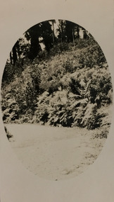
Photograph - Marysville, c.1926
Henry Beater Christian (1886-1962) , was a descendant of one of the earliest settler families in Kew. Employed at the Kew Asylum as a 'public servant', he was a skilled amateur photographer, photographing numerous scenes in Kew and on his travels around Victoria. The majority of his photographs date from 1916 to 1929. His finest photographs are housed in two photograph albums. Digital copy of a photograph from page 20 of the 47-page photograph album containing 261 gelatinous silver images, loaned by Diane Washfold with permission given to digitise and hold a copy in our collection. This photograph, dating from c.1926, forms part of a group of photos taken on a bushwalking trip to Marysville, Victoria. John Chapman has written in 'Bushwalking Clubs - A Brief History', about the establishment in Victoria of the first bushwalking club in 1888, and the popularisation of bushwalking during the interwar period. This photograph is of native vegetation beside a road at Marysville. The image was framed by an oval shape during the development process. henry beater christian (1886-1962), landscape photography, kew (vic.) — yarra river, christian-washfold collection, photograph albums, bushwalking -- victoria, marysville (vic.) -
 Kew Historical Society Inc
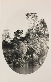
Photograph - Tambo River, 1926
Henry Beater Christian (1886-1962) , was a descendant of one of the earliest settler families in Kew. Employed at the Kew Asylum as a 'public servant', he was a skilled amateur photographer, photographing numerous scenes in Kew and on his travels around Victoria. The majority of his photographs date from 1916 to 1929. His finest photographs are housed in two photograph albums. Digital copy of a photograph from page 31 of the 47-page photograph album containing 261 gelatinous silver images, loaned by Diane Washfold with permission given to digitise and hold a copy in our collection. John Chapman has written in 'Bushwalking Clubs - A Brief History', about the establishment in Victoria of the first bushwalking club in 1888, and the popularisation of bushwalking during the interwar period. Henry Christian's 'walks' appear to have been undertaken solely or with a companion/s. This black and white photo is part of a group of six photos taken on an 18 kilometre walking trip between Bruthen and Swan Reach in East Gippsland in 1926. The route of the walk followed the Tambo River. The photographer has focussed the view using an oval frame during the development process."BRUTHEN TO SWAN REACH 1926"henry beater christian (1886-1962), landscape photography, christian-washfold collection, photograph albums, bushwalking, bruthen, swan reach, tambo river, east gippsland -
 Kew Historical Society Inc
Map, MMBW, MMBW Town of Kew, 1910-21
The Melbourne and Metropolitan Board of Works (MMBW) was established by an act of the Victorian Parliament in 1890 to prepare for and to implement a sewerage and water reticulation system across what was then inner Melbourne, its surrounding and middle distance suburbs, including Kew. The MMBW was disbanded in 1991.The map collection of the Kew Historical Society has at its core the historic maps assembled and originally stored in the City Engineer's Department of the City of Kew. These include maps in a number of scales. The vast majority of maps were produced by the MMBW in the first two decades of the twentieth century, and are solid working maps, backed by linen for durability. These maps are historically significant to Kew, the City of Boroondara and to the history of the development of state utilities in Victoria. A number of the Kew maps have additional details added by former municipal officers, including the levels reached by various floods. As these were working documents, information was added to them long after the period of their initial production and distribution.Early map of the Town of Kew, created after 1910, at a scale 440 ft to 1 inch. The 'assembled' map by the City of Kew Engineer's Department includes scaled down copies of The Melbourne and Metropolitan Board of Works maps, Nos. 39, 40, 64, 65, 66, 67, 68, and 117. The map covers the entirety of the Town of Kew, bordered on its north and west by the River Yarra, by Burke Road in the East and Barkers Road in the south. The map shows the extent of urban development by that time, prominent institutions and the outlines of built structures in the municipality. TOWN OF KEW / SCALE 400 FEET TO 1 INCHmelbourne & metropolitan board of works, mmbw maps, mmbw plans, town of kew, cartography -
 Kew Historical Society Inc
Map, MMBW, MMBW Plan No.39 Kew & Heidelberg, 1900-1910
The Melbourne and Metropolitan Board of Works (MMBW) was established by an act of the Victorian Parliament in 1890 to prepare for and to implement a sewerage and water reticulation system across what was then inner Melbourne, its surrounding and middle distance suburbs, including Kew. The MMBW was disbanded in 1991.The map collection of the Kew Historical Society has at its core the historic maps assembled and originally stored in the City Engineer's Department of the City of Kew. These include maps in a number of scales. The vast majority of maps were produced by the MMBW in the first two decades of the twentieth century, and are solid working maps, backed by linen for durability. These maps are historically significant to Kew, the City of Boroondara and to the history of the development of state utilities in Victoria. A number of the Kew maps have additional details added by former municipal officers, including the levels reached by various floods. As these were working documents, information was added to them long after the period of their initial production and distribution.Early map of part of the Borough of Kew, created in the first decade of the twentieth century, at a scale 160 ft to 1 inch. The map covers what was then the north western section of Kew, bordered on its north by Wills Street and the Kew Lunatic Asylum, in the west by the River Yarra [and the later added Yarra Boulevard] , by Princess Street in the East and Holroyd Street in the south. The map shows the extent of urban development by that time, prominent institutions and the outlines of built structures in the municipality. Contour lines were added in ink to the map at a later stage.MELBOURNE AND METROPOLITAN BOARD OF WORKS / PLAN NO. 39 / KEW & HEIDELBERGmelbourne & metropolitan board of works, mmbw maps, mmbw plans, borough of kew, cartography -
 Kew Historical Society Inc
Map, MMBW, MMBW Plan No.40 Collingwood & Kew, 1900-1910
The Melbourne and Metropolitan Board of Works (MMBW) was established by an act of the Victorian Parliament in 1890 to prepare for and to implement a sewerage and water reticulation system across what was then inner Melbourne, its surrounding and middle distance suburbs, including Kew. The MMBW was disbanded in 1991.The map collection of the Kew Historical Society has at its core the historic maps assembled and originally stored in the City Engineer's Department of the City of Kew. These include maps in a number of scales. The vast majority of maps were produced by the MMBW in the first two decades of the twentieth century, and are solid working maps, backed by linen for durability. These maps are historically significant to Kew, the City of Boroondara and to the history of the development of state utilities in Victoria. A number of the Kew maps have additional details added by former municipal officers, including the levels reached by various floods. As these were working documents, information was added to them long after the period of their initial production and distribution.Early map of part of the Borough of Kew, created in the first decade of the twentieth century, at a scale 160 ft to 1 inch. The map covers what was then the south western section of Kew, bordered on its north by Studley Park Road, in the west by Walmer Street and the River Yarra, by High Street South and Princess Street in the East and Barkers Road in the south. The map shows the extent of urban development by that time, prominent institutions and the outlines of built structures in the municipality. Contour lines and historic flood levels were added in ink to the map at a later stage.MELBOURNE AND METROPOLITAN BOARD OF WORKS / PLAN NO. 40 / COLLINGWOOD & KEWmelbourne & metropolitan board of works, mmbw maps, mmbw plans, borough of kew, cartography -
 Kew Historical Society Inc
Map, MMBW, MMBW Plan No.64 Kew & Heidelberg, 1900-1910
The Melbourne and Metropolitan Board of Works (MMBW) was established by an act of the Victorian Parliament in 1890 to prepare for and to implement a sewerage and water reticulation system across what was then inner Melbourne, its surrounding and middle distance suburbs, including Kew. The MMBW was disbanded in 1991.The map collection of the Kew Historical Society has at its core the historic maps assembled and originally stored in the City Engineer's Department of the City of Kew. These include maps in a number of scales. The vast majority of maps were produced by the MMBW in the first two decades of the twentieth century, and are solid working maps, backed by linen for durability. These maps are historically significant to Kew, the City of Boroondara and to the history of the development of state utilities in Victoria. A number of the Kew maps have additional details added by former municipal officers, including the levels reached by various floods. As these were working documents, information was added to them long after the period of their initial production and distribution.Early map of part of the Borough of Kew, created in the first decade of the twentieth century, at a scale 160 ft to 1 inch. The map covers what was then the northern most part of Kew, bordered on its north and west by the Yarra River, in the East by Connor's Creek and by the Asylum in the south. The map shows the extent of urban development by that time, prominent institutions and the outlines of built structures in the municipality. Contour lines and historic flood levels were added in ink to the map at a later stage.MELBOURNE AND METROPOLITAN BOARD OF WORKS / PLAN NO. 64 / KEW & HEIDELBERGmelbourne & metropolitan board of works, mmbw maps, mmbw plans, borough of kew, cartography -
 Kew Historical Society Inc
Map, MMBW, MMBW Plan No.65 Kew & Heidelberg, 1900-1910
The Melbourne and Metropolitan Board of Works (MMBW) was established by an act of the Victorian Parliament in 1890 to prepare for and to implement a sewerage and water reticulation system across what was then inner Melbourne, its surrounding and middle distance suburbs, including Kew. The MMBW was disbanded in 1991.The map collection of the Kew Historical Society has at its core the historic maps assembled and originally stored in the City Engineer's Department of the City of Kew. These include maps in a number of scales. The vast majority of maps were produced by the MMBW in the first two decades of the twentieth century, and are solid working maps, backed by linen for durability. These maps are historically significant to Kew, the City of Boroondara and to the history of the development of state utilities in Victoria. A number of the Kew maps have additional details added by former municipal officers, including the levels reached by various floods. As these were working documents, information was added to them long after the period of their initial production and distribution.Early map of part of the Borough of Kew, created in the first decade of the twentieth century, at a scale 160 ft to 1 inch. The map covers what was then the south central part of Kew, bordered on its north by Malmsbury Street, in the west by Florence Avenue, in the south by Barkers Road, and in the east by Princess Street. The map shows the extent of urban development by that time, prominent institutions and the outlines of built structures in the municipality. Contour lines were added in ink to the map at a later stage.MELBOURNE AND METROPOLITAN BOARD OF WORKS / PLAN NO. 65 / KEW & HEIDELBERGmelbourne & metropolitan board of works, mmbw maps, mmbw plans, borough of kew, cartography -
 Kew Historical Society Inc
Map, MMBW, MMBW Plan No.66 Kew, 1900-1910
The Melbourne and Metropolitan Board of Works (MMBW) was established by an act of the Victorian Parliament in 1890 to prepare for and to implement a sewerage and water reticulation system across what was then inner Melbourne, its surrounding and middle distance suburbs, including Kew. The MMBW was disbanded in 1991.The map collection of the Kew Historical Society has at its core the historic maps assembled and originally stored in the City Engineer's Department of the City of Kew. These include maps in a number of scales. The vast majority of maps were produced by the MMBW in the first two decades of the twentieth century, and are solid working maps, backed by linen for durability. These maps are historically significant to Kew, the City of Boroondara and to the history of the development of state utilities in Victoria. A number of the Kew maps have additional details added by former municipal officers, including the levels reached by various floods. As these were working documents, information was added to them long after the period of their initial production and distribution.Early map of part of the Borough of Kew, created in the first decade of the twentieth century, at a scale 160 ft to 1 inch. The map covers what was then the south eastern part of Kew, bordered on its north by Adeney Avenue, in the west by Sackville Street, in the south by Barkers Road, and in the east by Burke Road. The map shows the extent of urban development by that time, prominent institutions and the outlines of built structures in the municipality. Contour lines were added in ink to the map at a later stage.MELBOURNE AND METROPOLITAN BOARD OF WORKS / PLAN NO. 66 / KEW melbourne & metropolitan board of works, mmbw maps, mmbw plans, borough of kew, cartography -
 Kew Historical Society Inc
Map, MMBW, MMBW Plan No.67 Kew, 1900-1910
The Melbourne and Metropolitan Board of Works (MMBW) was established by an act of the Victorian Parliament in 1890 to prepare for and to implement a sewerage and water reticulation system across what was then inner Melbourne, its surrounding and middle distance suburbs, including Kew. The MMBW was disbanded in 1991.The map collection of the Kew Historical Society has at its core the historic maps assembled and originally stored in the City Engineer's Department of the City of Kew. These include maps in a number of scales. The vast majority of maps were produced by the MMBW in the first two decades of the twentieth century, and are solid working maps, backed by linen for durability. These maps are historically significant to Kew, the City of Boroondara and to the history of the development of state utilities in Victoria. A number of the Kew maps have additional details added by former municipal officers, including the levels reached by various floods. As these were working documents, information was added to them long after the period of their initial production and distribution.Early map of part of the Borough of Kew, created in the first decade of the twentieth century, at a scale 160 ft to 1 inch. The map covers what was then the north central part of Kew, bordered on its north by the Outer Circle Railway Spruzen and Beresford Avenues, in the west by Princess Street, in the south by High Street, and in the east by (about) Belford Road. The map shows the extent of urban development by that time, prominent institutions and the outlines of built structures in the municipality. Contour lines were added in ink to the map at a later stage.MELBOURNE AND METROPOLITAN BOARD OF WORKS / PLAN NO. 67 / KEW melbourne & metropolitan board of works, mmbw maps, mmbw plans, borough of kew, cartography -
 Kew Historical Society Inc
Map, MMBW, MMBW Plan No.68 Kew, 1900-1910
The Melbourne and Metropolitan Board of Works (MMBW) was established by an act of the Victorian Parliament in 1890 to prepare for and to implement a sewerage and water reticulation system across what was then inner Melbourne, its surrounding and middle distance suburbs, including Kew. The MMBW was disbanded in 1991.The map collection of the Kew Historical Society has at its core the historic maps assembled and originally stored in the City Engineer's Department of the City of Kew. These include maps in a number of scales. The vast majority of maps were produced by the MMBW in the first two decades of the twentieth century, and are solid working maps, backed by linen for durability. These maps are historically significant to Kew, the City of Boroondara and to the history of the development of state utilities in Victoria. A number of the Kew maps have additional details added by former municipal officers, including the levels reached by various floods. As these were working documents, information was added to them long after the period of their initial production and distribution.Early map of part of the Borough of Kew, created in the first decade of the twentieth century, at a scale 160 ft to 1 inch. The map covers what was then the north central part of Kew, bordered in the north by Oak Avenue, in the west by the Yarra River and Connor's Creek, in the south by Beresford and Carnegie Avenues, and in the east by Glass's Creek and Burke Road. The map shows the extent of urban development by that time, prominent institutions and the outlines of built structures in the municipality. Contour lines and the levels of historic floods were added in ink to the map at a later stage.MELBOURNE AND METROPOLITAN BOARD OF WORKS / PLAN NO. 68 / KEW melbourne & metropolitan board of works, mmbw maps, mmbw plans, borough of kew, cartography -
 Kew Historical Society Inc
Map, MMBW, MMBW Plan No.117 Heidelberg & Kew, 1900-1910
The Melbourne and Metropolitan Board of Works (MMBW) was established by an act of the Victorian Parliament in 1890 to prepare for and to implement a sewerage and water reticulation system across what was then inner Melbourne, its surrounding and middle distance suburbs, including Kew. The MMBW was disbanded in 1991.The map collection of the Kew Historical Society has at its core the historic maps assembled and originally stored in the City Engineer's Department of the City of Kew. These include maps in a number of scales. The vast majority of maps were produced by the MMBW in the first two decades of the twentieth century, and are solid working maps, backed by linen for durability. These maps are historically significant to Kew, the City of Boroondara and to the history of the development of state utilities in Victoria. A number of the Kew maps have additional details added by former municipal officers, including the levels reached by various floods. As these were working documents, information was added to them long after the period of their initial production and distribution.Early map of part of the Borough of Kew, created in the early twentieth century, at a scale 160 ft to 1 inch. The map covers what was then the north eastern part of Kew showing the natural landscape and limited development on the south side of the Yarra River. In the Kew section, south of the river, the land is occupied currently by the Greenacres and Kew Golf Clubs. The map shows the extent of urban development by that time and the outlines of the few built structures in the municipality. The height above sea level of all parts of the landscape are indicated numerically in feet. Contour lines and the levels of historic floods were added in ink to the map at a later stage. MELBOURNE AND METROPOLITAN BOARD OF WORKS / PLAN NO. 117 / HEIDELBERG & KEW melbourne & metropolitan board of works, mmbw maps, borough of kew, cartography, mmbw plan no. 117, kew (vic.) -- maps, heidelberg (vic.) -- maps -
 Kew Historical Society Inc
Map, MMBW, River Yarra Beautification Schemes, c.1913
The Melbourne and Metropolitan Board of Works (MMBW) was established by an act of the Victorian Parliament in 1890 to prepare for and to implement a sewerage and water reticulation system across what was then inner Melbourne, its surrounding and middle distance suburbs, including Kew. The MMBW was disbanded in 1991.The map collection of the Kew Historical Society has at its core the historic maps assembled and originally stored in the City Engineer's Department of the City of Kew. These include maps in a number of scales. The vast majority of maps were produced by the MMBW in the first two decades of the twentieth century, and are solid working maps, backed by linen for durability. These maps are historically significant to Kew, the City of Boroondara and to the history of the development of state utilities in Victoria. A number of the Kew maps have additional details added by former municipal officers, including the levels reached by various floods. As these were working documents, information was added to them long after the period of their initial production and distribution.Map of the City of Kew showing part of the River Yarra Beautification Schemes. The map shows development to date and the flood levels reached in 1923 and 1924. This map may have been adapted from an earlier map, as most development in central Kew and Studley Park had occurred by this date yet numerous streets are not represented. Public buildings and institutions are clearly represented and named on the map as are significant public transport infrastructure (eg the Outer Circle railway).MELBOURNE AND METROPOLITAN BOARD OF WORKS / RIVER YARRA BEAUTIFICATION SCHEMES / SCHEME / SCALE 10 CHAINS TO AN INCHmelbourne & metropolitan board of works, mmbw maps, mmbw plans, city of kew, flood levels -- kew (vic.), cartography -
 Maryborough Midlands Historical Society operating the Worsley Cottage Museum
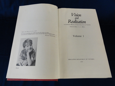
Books, Vision and Realisation, 1973
Information on Maryborough and district schools and their histories.Information invaluable as access to local school historic records is currently unavailable.A set of three hardcover (red) books detailing the history of education in Victoria. Volume 1 (general account of the development of education), Volume 2 (schools in the Wimmera, central Victoria and Geelong), Volume 3 (Melbourne, upper Goulburn, upper Murray, Gippsland regions). Published by the Education Department of Victoria. -
 Surrey Hills Historical Society Collection
Book, Raheen: a house and its people, 2007
Raheen is a 120 year old Victorian house owned by Richard and Jeanne Pratt. Mrs Jeanne Pratt commissioned the book and this copy was presented to Sue Barnett on a visit by members of the Boroondara Historical Societies. The visit was organised by local member Mr Josh Frydenburg. 92p. ill. bibliog., Raheen was a grand two-storey red brick house in the Italianate Style, with a prominent tower and an arcaded loggia on two levels. This book explores its history, restoration and further development over many years. 92p. ill. bibliog., Raheen was a grand two-storey red brick house in the Italianate Style, with a prominent tower and an arcaded loggia on two levels. This book explores its history, restoration and further development over many years.Endpaper: Surrey Hills Historical Society / Jeanne Pratt / 27/7/2013(mr) ian allen oam, (mr) william lawrence bailieu, ehud barak, (dr) james broadbent, (mr) robert bruce, (mr) george h w bush, (mrs) barbara pierce bush, (mr) arthur calwell, (ms) jane dennithorne, (mr) eamon de valera, (sir) james augustine gobbo, (mr) lloyd hill, (mr) william morris hughes, (lord) (mr) immanuel jakobovits, (mr) philip johnson, (cardinal) (mr) walter kaspar, moshe katsav, (mr) james robert knox, (mr) terence lane, (mr) edward latham, (mr) michael lehany, (dr) (mr) miles lewis, (mr) sam lipski am, (sir) (mr) thomas francis little, (mr) peter lovell, (mr) egidio lunardon, (mr) (cardinal) jean-marie lustiger, (mr) daniel patrick mannix, (sir) (mr) robert gordon menzies, (mr) henry miller, (mr) glen murcutt ao, (mr) benjamin netanyahu, (mr) ngo dinh diem, (mr) phillip nikolitsis, i (eoh) m(eng) pei, (mr) shimon peres, (mr) joseph reed, (mr) yves st laurent, (mr) william salway, (mr) james henry scullin, jessie serle, (mr) justin david simonds, (mrs) heliose waislitz, (miss) heliose pratt, (mr) john wren, (sir) (mr) henry john wrixon, (mr) richard pratt, (mrs) jeanne pratt, raheen, historical buildings, kew, victoria, italianate style, house names