Showing 409 items
matching victoria 1857
-
 Uniting Church Archives - Synod of Victoria
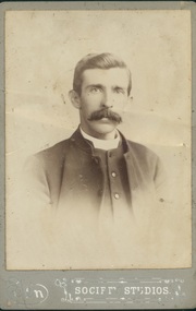
Photograph, Undated c. 1891
Rev. John Thompson Field (1861 - 1938). Born at Geelong. Went to Papua as an unmarried Probationer. Ordained 1891. Served at: Dobu, Papua (1891), Tubetube (1893), Heywood (1901), Hamilton (1904), Camperdown (1907), Brighton (1909), Ubuia, Papua (1913), Dunolly & Tarnagulla (1914), Terang (1917), Williamstown (1920), Coburg & Moreland (1924), Devonport (1928), Supernumerary Hawthorn (1929). Married Frances Mary Harding (1857 - 1909) in Papua.Sepia toned head and shoulders studio portrait of the Rev. J. T. Field.rev john thompson field, methodist, minister, papua, frances mary harding -
 Uniting Church Archives - Synod of Victoria
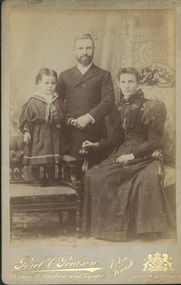
Photograph, Undated c
Possibly Rev Dr William Williams (1848 - 1913) with his wife Edith Skelton Williams nee Wimble (1857 - 1942) and son Percival Wimble Williams (1881 - 1936)Sepia toned studio portrait of Mr Williams with his wife and son."To Mr & Mrs Holden with Christian Love from Mr & Mrs Williams" -
 Uniting Church Archives - Synod of Victoria
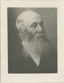
Photograph, Undated c.1890
Rev. Francis Robert Muter Wilson was born in 1832 near Hamilton, Lanarkshire, Scotland. He entered Edinburgh University in 1848 and started theological studies in 1852 at New College Edinburgh. He completed theological studies in 1856 and arrived in Melbourne in September 1857. He briefly preached to a small congregation at Brighton, and then early in 1858 he supplied the pulpit of Dr. McKay in Sydney. Later in 1858 he received a call to Camperdown and was ordained there in December 1858. Married Lillie Tait in Geelong in April 1861. Moderator of the Presbyterian Church of Victoria in 1875. Called to Kew in 1877 and served there until he was demitted in 1898. Convenor of the Business Committee of Assembly. Died June 9 1903.B & W head and shoulders studio portrait of Rev Francis Robert M. Wilson, printed on buff card.Rev. F.R.M. Wilson 1876 - 1897francis robert muter wilson, presbyterian, minister, edinburgh, kew, moderator -
 Uniting Church Archives - Synod of Victoria
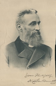
Photograph
Matthew Burnett (1839 - 1896). Wesleyan temperance evangelist. Born in Yorkshire, came to Australia in 1857 with his wife Sarah Gibson. He spent the years 1864 to 1867 on the goldfields evangelising against drink and securing temperance pledges. Sarah Burnett died in 1871 and Matthew returned to England in 1873, meeting leading temperance reformers. He returned to Australia in the mid-1870s. He went to South Australia, Western Australia, Tasmania and New Zealand as a temperance campaigner, and claimed to have received pledges from 140,000 people. He returned to England in 1890 and died at Scarborough in 1896.Sepia toned head and shoulders studio portrait of Matthew Burnett in three quarter profile."Yours faithfully Matthew Burnett"matthew burnett, sarah gibson, temperance, evangelist, wesleyan -
 Uniting Church Archives - Synod of Victoria
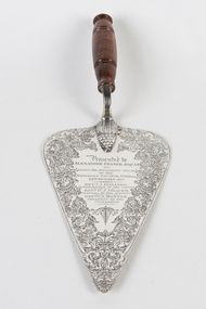
Ceremonial object - Commemorative Trowel
Commemorative trowel from Wesley Church St Kilda, 22 October 1857. Alexander Fraser (1802-1888), businessman and politician. Fraser lived at St Kilda and in 1857 was elected to its first Municipal Council; in 1859 he became chairman and mayor in 1864-65. An active churchman, he held most important offices in the Wesleyan Church and for thirty years was treasurer of the supernumerary fund, which he helped Rev. Daniel Draper to found. Dour and pious, Fraser was conscientious in fulfilling his political duties. He presided at numerous meetings and laid countless foundation stones.Silver trowel with polished wooden handle. Trowel decorated around the edges and with an inscription.Presented to Alexander Fraser Esq J.P. on laying the foundation stone of the Wesley Church St Kilda 22nd October 1857. Rev. J. Harding Superintendent of the church. Rev. D.J. Draper Chairman of the District. Rev. J.A. Manton President of the Conference.wesleyan church st kilda, fraser, alexander, draper, daniel -
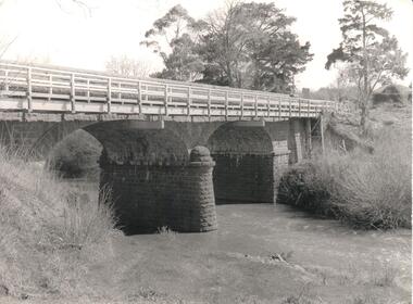 Hume City Civic Collection
Photograph, Early 1970s
The Macedon Street Bridge over Jacksons Creek is important because it was built on one of Victoria's first important roads. It replaced a smaller lighter bridge in 1857 and continued to be used until the early 1970s.A black and white photograph of a two arched bluestone bridge over a creek. A wooden post and rail fence painted white has been constructed in front of the original stone wall of the bridge.bridges, bluestone bridges, jacksons creek, macedon street, george evans collection -
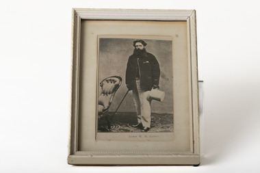 Chiltern Athenaeum Trust
Photograph, JUDGE W. H. GAUNT
... Gazette (Victoria), 22 Feb, 15 Aug 1856, 30 June 1857, 5 Jan 1858... Gazette (Victoria), 22 Feb, 15 Aug 1856, 30 June 1857, 5 Jan 1858 ...This photograph is a copy displayed in the Australian Dictionary of Biography. The original photograph is in the La Trobe Collection in the State Library of Victoria. William Henry Gaunt (1830-1905), judge, was born on 27 July 1830 at Leek, Staffordshire, England, son of John Gaunt, banker, and his wife Mary, née Bakewell. Educated at Leek Grammar School and Whitchurch, Salop, he migrated to Melbourne, and entered the Victorian public service and was rapidly promoted. By March 1854 he was chief clerk at Beechworth, the administrative centre of the Ovens goldfield. In July 1855 the resident warden commended Gaunt as 'a highly valuable public servant' with an intimate knowledge of the district and the 'temper and disposition of the miners'. Appointed sub-warden in the Beechworth district in January 1856 and a Chinese protector in August, he was given control of the extensive Woolshed district. When European miners attacked a party of Chinese at the Buckland River diggings in May 1857 Gaunt was sent to restore order. One of his proclamations, issued in Chinese characters, concluded 'W. H. Gaunt, your protector—tremble and obey!' In June he was appointed a police magistrate and next month was sent to take charge at the Buckland where the Chinese had been expelled from the diggings; the police force assisting him was led by Robert O'Hara Burke. In January 1858 Gaunt was appointed a warden, in November was transferred to Chiltern, north of Beechworth, and in August 1859 was made a commissioner of crown lands. In February 1860 Gaunt was appointed a coroner of Victoria, acting at Indigo, near Chiltern. In April 1865 he was transferred to Beechworth, became visiting justice of the gaol and later moved to Sandhurst. In January 1869 he was appointed returning officer for the mining district of Ballarat and visiting justice of the gaol. He was associated with this area for the rest of his life and won high repute for his integrity. In 1874 he chaired the inaugural meeting of the first Australian competitive swimming club. For years he studied law and was called to the Bar in December 1873. He was one of the many public servants dismissed by Graham Berry on 9 January 1878 (Black Wednesday). After petitioning the Queen in vain over his dismissal he began practice in Ballarat as a barrister. He soon became a leading authority on mining laws; one of the cases in which he was involved was the lengthy inquest on the bodies of the twenty-two miners drowned in the New Australasian mine disaster at Creswick in 1882. He was appointed a temporary judge of the Insolvency Court in 1889 and a County Court judge in 1891. In 1900 he was chairman of the royal commission which considered Metropolitan Board of Works matters, and in 1902 was president of the inquiry into the unification of municipalities in Victoria. In 1860 Gaunt married Elizabeth Mary, the youngest daughter of Frederick Palmer; they had nine children. Of the surviving five sons and two daughters, Ernest Frederick Augustus and Guy Reginald Archer both became admirals and were knighted; Cecil Robert became a lieutenant-colonel, Clive Herbert a government advocate in Rangoon and Mary (Mrs H. L. Miller) one of the first women students to enrol at the University of Melbourne (1881), although she did not complete her degree; she became a successful novelist. Gaunt died on 5 October 1905. An anonymous colleague said: 'I don't think he was ever excelled as a police magistrate, and during the many years he was on the County Court bench he earned the highest regard. His capacities were as unquestioned as his integrity, and more could not be said of any judge'. Select Bibliography Votes and Proceedings (Legislative Assembly, Victoria), 1878, 3, (58) Government Gazette (Victoria), 22 Feb, 15 Aug 1856, 30 June 1857, 5 Jan 1858, 16 Aug 1859, 3 Feb 1860, 7 Mar, 11 Oct 1862, 28 Mar, 4 Apr 1865, 17 May 1867, 9 June 1868, 22, 29 Jan 1869 Ovens and Murray Advertiser, 21 May 1857, 11 Mar 1865 Colonial Secretary's in-letters, goldfields, 25 Mar 1854, 21 July, 18 Nov 1855, 22 Aug 1857 (Public Record Office Victoria) scrapbook and newsclippings (privately held). Related Entries in NCB Sitesview family tree Gaunt, Mary Eliza (daughter)go to ADB entryPhotograph of Judge W. H. Gaunt standing beside chair holding top hat and cane, under glass, in cream frame with cream matte.Printed name underneath: JUDGE W. H. GAUNT -
 Clunes Museum
Sign - DISPLAY PANEL, 2000
COPIES OF DISPLAY PANELS DONATED TO THE PEOPLE OF CLUNES BY THE HUGH WILLIAMSON FOUNDATION.INTERPRETIVE DISPLAY PANEL DEPICTING HISTORY OF SCHOOL DAYS IN CLUNES. WOODEN DISPLAY PANEL AND LAMINATED COPY.SCHOOL DAYS CHILDREN OF EARLY GOLDFIELD TOWNS WERE TAUGHT IN TENT SCHOOLS.THESE SCHOOLS WERE EASILY MOVED TO THE SITE OF THE LATEST GOLDRUSH. WITH GREATER COMMUNITY STABILITY PERMANENT SCHOOLS WERE ESTABLISHED. CLUNES STATE SCHOOL NO. 1552 WAS OPENED IN JULY 1875 ON LAND DONATED BY RIVETT H. BLAND, MANAGER OF THE PORT PHILIP GOLD MINING CO. SHORTLY BEFORE WORLD WAR ONE, THIS SCHOOL BECAME VICTORIA,S THIRD HIGHER ELEMENTARY SCHOOL. TODAY IT IS STILL USED TO EDUCATE THE CHILDREN OF CLUNES STATE SCHOOL NO. 136 WAS BUILT IN 1881 ON THE SITE OF AN EARLIER TEMPORARY SCHOOL THAT WAS BUILT IN 1857. THE DESIGN WAS FIRST USED AT HORSHAM. AND INCLUDES AN EARLY EXAMPLE OF A LARGE SCHOOL VERANDAH. IN 1892 THIS SCHOOL AMALGAMATED WITH STATE SCHOOL NO. 1552 AND WAS USED AS THE INFANT SCHOOL. IT CLOSED ITS DOORS IN 1922 AND WAS LATER USED AS A MILL FOR THE CLUNES KNITTING AND MAUFACTURING CO. LTD. IT NOW HOUSES THE CLUNES BOTTLE MUSEUM THE CLUNES CATHOLIC SCHOOL OPENED IN 1875 AND CLOSED IN 1926 THE LATEST EDUCATIONAL ASSET AT CLUNES IS A CAMPUS OF WESLEY COLLEGE. BLENDINGHISTORIC BUILDINGS AND MODERN ARCHITECTURE THE CAMPUS IS SITUATED IN SERVICE STREETlocal history, civic momentoes, presentations, williamson, hugh foundation -
Clunes Museum
Book, CASTLEMAINE MAIL, THE PENNYWEIGHT KIDS 1852 - 1857, 1988
... ON THE GOLDFIELDS AT FOREST CREEK, VICTORIA, 1852-1857 HANDWRITTEN IN BLUE ...SMALL VOLUME RELATING TO DEATH OF CHILDREN ON THE GOLDFIELDS AT FOREST CREEK, VICTORIA, 1852-1857YELLOW COVER WITH IMAGES DRAWN IN BLACK INK BY THE AUTHOR, OF A SET OF GOLD SCALES, A MAN WASHING GRAVEL THROUGH A CRADLE FOR GOLD AND A WOMENT LOOKING OVER A CHILD'S CRADLEnon-fictionSMALL VOLUME RELATING TO DEATH OF CHILDREN ON THE GOLDFIELDS AT FOREST CREEK, VICTORIA, 1852-1857local history, book, forest creek victoria australia, children on the golddfields -
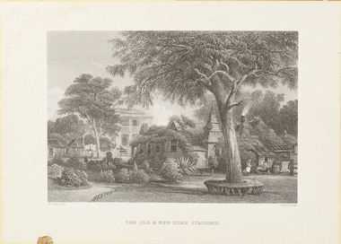 Wangaratta Art Gallery
Print, Arthur Willmore et al, The Old & New Home Stations, Victoria (Bontharambo, Wangaratta), 1873-1876
This etching by British engraver Arthur Willmore was created from Russian born artist Nicholas Chevalier’s original watercolour landscape of Bontharambo, Wangaratta (Chevalier’s watercolour is held in the collection of the National Library of Australia). Chevalier moved to Australia during the Colonial period and is famous for his landscape paintings, which were most commonly commissioned by wealthy landowners or merchants wanting to record their material success. Bontharambo is a historic property located in Wangaratta which was made famous by pastoralist Joseph Docker who took up the Bontharambo run in 1838 and has remained in the family since. The historic homestead on the property was built between 1857-1859 and was designed by architect Thomas Watts.ColonialWangaratta Art Gallery CollectionA rectangular landscape etching of the homes on Bontharambo station printed in black ink on off-white paper.Obverse: N. Chevalier/ A. Willmore/ THE OLD & NEW HOME STATIONSwangaratta art gallery, arthur willmore, nicholas chevalier, bontharambo, wangaratta -
 Wangaratta Art Gallery
Work on paper, Maurice Cantlon, Bontharambo, 1965
Cantlon is widely known for his illustrative paintings of Victorian historic homes, and he wrote and illustrated Homesteads of Victoria 1836-1900 published by Georgian House in 1967. Bontharambo is a homestead located in Wangaratta and was built in 1857-9. This homestead plays a prominent role in the history of Wangaratta and the pastoral history of Victoria. Rural City of Wangaratta Collection. Purchased with funds from the Wangaratta Art Council.An black ink sketch of the Bontharambo homestead on white paper.Obverse: Cantlon 65/ (bottom right)wangaratta art gallery, maurice cantlon, ink drawing, bontharambo, homestead -
 Stawell Historical Society Inc
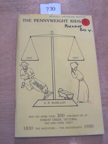
Book, A. R. McMillan, The Pennyweight Kids - 1852-1857, 1988
The Story of the children who lived and died with the killer diseases of the last century (1800's). Theere is a preservation order now on force to restore the cm=emetary.Yellow Card Cover with black in drawing of Large balance scale. A Miner slucing gravel to the left and a woman looking at an empty cradle to the rightThe Pennyweight Kids 1852 1857 A.R. McMillan Why did more than 200 children die at Forest Creek Victoria and who were They? 1830 The Ancestors - The Descendants 1930 Inside: To The Stawell Historical Society from the Authorcastlemaine -
Koorie Heritage Trust
Book, Bunce, Daniel et al, Australasiatic reminiscences of twenty-three years' wanderings in Tasmania and the Australias, 2000
This book is a reprint of the original journal entries of Daniel Bunce prior to 1857. A journal style record of travel within Tasmania and Australia for a period of 23 years beginning in March 1833. Arriving in Port Phillip in October 1839 early observations of the colony are most interesting. Chap.4; incidents in relation to the Aborigines at Hobart town; Chap.8; Tasmania - womens life, body decoration, clothing and scarification; Chap.9; Native chiefs with Buckley, the Wild white man; Chap.11; Journey to Westernport with natives (Derrimut, Benbow and Yammabook), foods - kangaroo and native porcupine; duties of women; Chap.12; Leichhardts journey, native names of flowers, fruits, etc. (Condamine River area); foods, treacherous natives near Fitzroy DownsThis book is a reprint of the original journal entries of Daniel Bunce prior to 1857. A journal style record of travel within Tasmania and Australia for a period of 23 years beginning in March 1833. Arriving in Port Phillip in October 1839 early observations of the colony are most interesting. Chap.4; incidents in relation to the Aborigines at Hobart town; Chap.8; Tasmania - womens life, body decoration, clothing and scarification; Chap.9; Native chiefs with Buckley, the Wild white man; Chap.11; Journey to Westernport with natives (Derrimut, Benbow and Yammabook), foods - kangaroo and native porcupine; duties of women; Chap.12; Leichhardts journey, native names of flowers, fruits, etc. (Condamine River area); foods, treacherous natives near Fitzroy Downsleichhardt, ludwig, 1813-1848. | leichhardt expedition, (1846-1847) | botany -- queensland. | botany -- tasmania. | queensland -- discovery and exploration. | tasmania -- description and travel -- to 1850. | victoria -- description and travel -- to 1850. | body - decoration. | body - scarification. | settlement and contacts - colonisation - 1788-1850. | costume and clothing. | food - meat - echidna. | settlement and contacts - explorers. | food. | hunting. | gathering - honey. | food - meat - kangaroo / wallaby. | language - vocabulary. -
Whitehorse Historical Society Inc.
Document, Petition presented 10 Nov 1857, 1857
Petition to Sir Henry Barkly, Governor in Chief of the Colony of Victoria requiring a public pound, signed by landholders, farmers, graziers and residents in and around Nunawading.Petition to Sir Henry Barkly, Governor in Chief of the Colony of Victoria requiring a public pound, signed by landholders, farmers, graziers and residents in and around Nunawading.Petition to Sir Henry Barkly, Governor in Chief of the Colony of Victoria requiring a public pound, signed by landholders, farmers, graziers and residents in and around Nunawading.local government, barkly, henry (sir), nunawading district roads board, pounds -
Whitehorse Historical Society Inc.
Document, Nunawading Road District, 1857
... ', proclamation by Sir Henry Barkly, Governor of the Colony of Victoria... 1857. Extract from Victoria Government Gazette no 91 ...A copy from Ivan Southall's 'A Tale of Box Hill', proclamation by Sir Henry Barkly, Governor of the Colony of Victoria, the name of Nunawading Road District. 6 Aug 1857.A copy from Ivan Southall's 'A Tale of Box Hill', proclamation by Sir Henry Barkly, Governor of the Colony of Victoria, the name of Nunawading Road District. 6 Aug 1857. Extract from Victoria Government Gazette no 91.A copy from Ivan Southall's 'A Tale of Box Hill', proclamation by Sir Henry Barkly, Governor of the Colony of Victoria, the name of Nunawading Road District. 6 Aug 1857.local government, nunawading road district, barkly, henry (sir) -
Whitehorse Historical Society Inc.
Document, Nunawading and District local government records
Records of the municipalities of Nunawading and Box Hill districtsRecords of the municipalities of Nunawading and Box Hill districts from Road District 1857 through to City of Nunawading 1994 and lists of location of records for each period within the Public Record Office. Extracts from PRO lists of holdings.Records of the municipalities of Nunawading and Box Hill districts local government, nunawading road district, shire of nunawading, borough of box hill, city of box hill, shire of blackburn and mitcham, city of nunawading, victoria. public record office -
 Whitehorse Historical Society Inc.
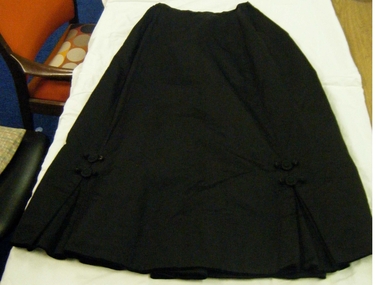
Clothing - Skirt, c1890
Skirt belonged to Grace Begg(born 15-9-1857). Worn by her at Mt Carmel sheep station, near Heathcote, Victoria. Station managed by her father John Begg. Grace married Russell Scott Thomas on 2 August 1890 at Heathcote and later lived in Albert Park. She was grandmother of Russell Alexander of Creek Road Mitcham (Russell Alexander Menswear Mitcham). His wife Coral wore the frock on occasions.c 1890 Black grograin material skirt, two double inverted pleats in front, two flat covered buttons and four acorn shaped buttons (covered) joined with rouleaux to the shape of frogs. Lined with silk and black velvet edging around the lower edge. Open at back with a placket closed with hooks and eyes. Two pleats each side of centre back seam.costume, female -
 Whitehorse Historical Society Inc.
Photograph, Grace Begg
Black and white photo of Grace Begg, born 15/9/1857, married Russell Scott Thomas 17/8/1890 at Heathcote, Victoria. Lived at Albert Park. Grandmother of Russell Alexander, Creek Road, Mitcham. (Russell's Menswear, Whitehorse Road, Mitcham). Cross Ref: NA2693.begg, grace, alexander, russell, stan russell menswear -
 Whitehorse Historical Society Inc.
document - Map, Melbourne Metro, 1978
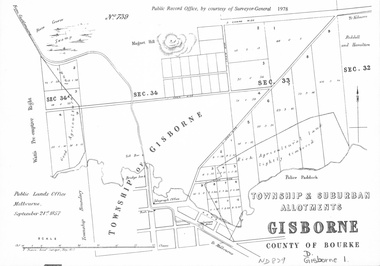
Collection of reproductions issued by the Public Record Office in 1978. Comprises: Allotments in the Black Forest, 1857; Township of Dandenong, 1856; Township and suburban allotments, Gisborne, 1857; Storing Yard allotments near the Melbourne Wharf, 1854; Town lots near the Railway Terminus, Melbourne, 1863; Parish of Prahran, 1853; Township of Sandridge, 1855; Township of Sunbury, 1857; River Yarra Yarra at the Queens Wharf, 1860.victoria. public record office, black forest, victoria, dandenong, gisborne, melbourne wharf, railway terminus, spencer street, melbourne, prahran, sandridge, sunbury, queens wharf -
 Whitehorse Historical Society Inc.
Document - Inventory, Nunawading Municipal Records Deposited with Public Records Office of Victoria (PROV)
Inventory of municipal records for the Nunawading Road District (1857-1872), Shire (1872-1925) and City (1945-1994); Shire of Blackburn and Mitcham (1925-1945) and Box Hill Borough (1925-1927) and City (1925-1994)8 A4 photocopies showing an inventory of municipal records dated between 1857 to 1945 lodged with the Public Records Office of Victoria.non-fictionInventory of municipal records for the Nunawading Road District (1857-1872), Shire (1872-1925) and City (1945-1994); Shire of Blackburn and Mitcham (1925-1945) and Box Hill Borough (1925-1927) and City (1925-1994)nunawading road district, shire of nunawading, city of nunawading, shire of blackburn and mitcham, city of box hill -
 Ballarat Heritage Services
Photograph - Colour, Clare Gervasoni, University of Melbourne Old Law Building, 2010, 29/09/2010
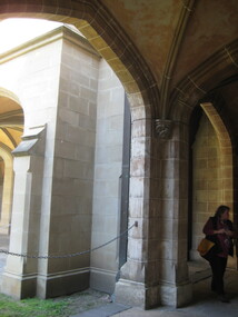
Melbourne University Old Physics Building (1889) was designed by Reed, Henderson and Smart. It later house the Univesity's Centre for Indigenous Education and a conference centre (2010).Colour photograph of the windows of the Melbourne University Old Physics Building.A plaque on the wall of this building states: In April, 1856 stonemasons woking on this building downed tools, marched to the city and inaugrated a movement which win the Eight Hour Day for building workers in Victoria. The victory became an international landmark in the history of the labour movement. Another plaque reads: This, the original building of the University was built of Tasmanian freestone between 1854 and 1857 to the design of F.M. White, architect. It was for many years the University's administrative centre, library, lecture rooms, and professorial residences. The east and west wings were extended in 1930 to the design of J.S. Gawler. In 1969, the quadrangle was completed by the addition of the southern wing which contains the council chamber, designed by R.E. Featherstone. university of melbourne, old law building, eight hour day, stonemasons, tasmanian freestone, f.m. white, j.s. gawler, r.e. featherstone -
 Ballarat Heritage Services
Photograph - Colour, Clare Gervasoni, University of Melbourne Old Law Building, 2010, 29/09/2010
Melbourne University Old Physics Building (1889) was designed by Reed, Henderson and Smart. It later house the Univesity's Centre for Indigenous Education and a conference centre (2010).Colour photograph of the windows of the Melbourne University Old Physics Building.A plaque on the wall of this building states: In April, 1856 stonemasons woking on this building downed tools, marched to the city and inaugrated a movement which win the Eight Hour Day for building workers in Victoria. The victory became an international landmark in the history of the labour movement. Another plaque reads: This, the original building of the University was built of Tasmanian freestone between 1854 and 1857 to the design of F.M. White, architect. It was for many years the University's administrative centre, library, lecture rooms, and professorial residences. The east and west wings were extended in 1930 to the design of J.S. Gawler. In 1969, the quadrangle was completed by the addition of the southern wing which contains the council chamber, designed by R.E. Featherstone. A third plaque states: These cloisters, commenced in 1853 and extended in 1930 nd 1969 were completed in 1981 through the generosity of the late Edward Stevens, a member of Council from 1926 until 1939. The work was also supported by the Wilson Trust and Sir Wilfred Brookes.university of melbourne, old law building, eight hour day, stonemasons, tasmanian freestone, cloisters, edward stevens, wilson trust, wildred brookes -
 Parliament of Victoria
Photograph of John Pascoe Fawkner, 1857
This photograph of John Pascoe Fawkner was commissioned by artist William Strutt in 1857. In 1907 Strutt gave the photograph to Victoria's London agent, Mr. Lake, to be presented to the Victorian Parliamentary Library. In a letter to Mr. Lake now in the library's archives, Strutt describes how he had planned to make use of the photograph in his artistic practice, and when finished with it, had promised to give the photograph to the Victorian Parliamentary Librarian Charles Ridgway (c.1801-1865). "That time then has come, late it is true, but alas Mr. Ridgeway [sic] is dead, so is Fawkner, but the old patriot will ever live in this portrait".Framed ambrotype portrait photograph of John Pascoe Fawkner seated and wearing a smoking cap. Note from William Strutt adhered verso. The ambrotype is a positive photographic image on a glass plate mounted inside a glazed frame with a gold-coloured inner-frame/preserver (possibly celluloid) and black velvet-covered backing board. Handwritten black ink verso: "John Pasco [sic] Fawkner/ This admirable portrait/ of the Founder of Melbourne is now presented in/ fulfilment of my/ promise (made years/ ago to the late Mr/ Ridgeway) to present it/ to the Parliament House/ Library of Melbourne./ William Strutt./ Wedsmnt [?] Dec' 18.1007."strutt, william, 1825-1915, fawkner, john pascoe, 1792-1869, ridgway, charles c.1801-1865, victorian parliamentary library -
 Otway Districts Historical Society
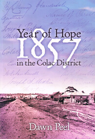
Book, Year of hope: 1857 in the Colac District, 2006
... settlement of Colac, Victoria, and its district. 1857; dawn peel ...The land, the settlers, and the social institutions which found or altered the character of the small settlement of Colac, Victoria, and its district.Year of hope: 1857 in the Colac district. Dawn Peel. 1st ed. Colac (Vic); Dawn Peel; 2006. x, 212 p.; illus, bibliography. Soft cover. ISBN 0 646 46270 9For Irene - a fellow historian. Dawn Peel. 6/10/06.1857; dawn peel; land; politics; aborigines; religion; history; social institutions; -
 Bendigo Historical Society Inc.
Slide - DIGGERS & MINING. THE CHINESE ON THE GOLD FIELDS, c1850s
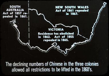
Diggers & Mining. The Chinese on the Gold Fields. Slide: Shows map of Victoria and part of South Australia and New South Wales. South Australia Act. Of 1857 repealed I 1861. New South Wales Act. Of 1861 repealed I 1867. Victoria Residence tax abolished in 1862. Act. Of 1855 repealed in 1865. The declining numbers of Chinese in the three colonies allowed all restrictions to be lifted in the 1860's. Markings: 2 2. Used as a teaching aid.hanimounteducation, tertiary, goldfields -
 Bendigo Historical Society Inc.
Slide - DIGGERS & MINING.GOLD, c1857
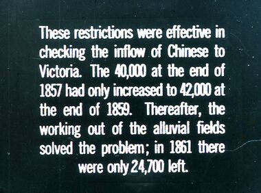
Diggers & Mining. Gold. These restrictions were effective in checking the inflow of Chinese to Victoria. The 40,000 at the end of 1857 had only increased to 42,000 at the end of 1859. Thereafter, the working out of the alluvial fields solved the problem; in 1861 there were only 24,000 left. Markings: 18 994.GOL. Used as a teaching aid.hanimounteducation, tertiary, goldfields -
 Bendigo Historical Society Inc.
Slide - DIGGERS & MINING. GOLD, c1857
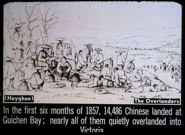
Diggers & Mining. Gold. Slide depicts lots of Chinese miners on their way to the gold fields. (Huyghue) The Overlanders. In the first six months of 1857, 14,486 Chinese landed at Guichen Bay; nearly all of them quietly overladed into Victoria. Markings: 6 994.GOL. Used as a teaching aid.hanimounteducation, tertiary, goldfields -
 Bendigo Historical Society Inc.
Document - BENDIGO TOWN HALL ''A GOLDFIELD' PALACE'' LEAFLET, 2002
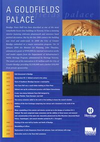
Bendigo Town Hall, Heritage Victoria ''A Goldfields Palace Blue Leaflet'' with coloured photographs and white text. Photographs courtesy of Westox Pty Ltd and the City of Greater Bendigo. 2002. Front page features the extensive work that would be undertaken for the restoration. A time line beginning 1851, gold discovered in Bendigo. 1854 German-born W. C. Vahland arrived in the colony. 1855 Town of Sandhurst (Bendigo) became a municipality. 1856 First Town Hall was a small timber building on View point. 1857 Vahland sets up his architectural practice with Robert Getzschmann. 1859 A new, two-storey Italianate Town hall designed by George Fletcher, Town Surveyor, was built. 1866-77 Two-storey extension added to the north of the building to house the council chamber. 1871-72 Addition of the Corn Exchange comprising two storeys and a basement to the north of the building. 1878-87 Major remodelling of the exterior and interior carried out to the designs of architect W. C. Vahland. The work comprised major extensions and the addition of three towers and mansard roof, reconstruction of the main stair, decorative plasterwork by Otto Waschatz (decorated Royal palace, Copenhagen), and council chamber painted by W. J. Straugher. 1902 Painting of the main hall by Coulter and Smith of Bendigo. 1913-15 Remodelling of offices. 1926 Replacement of main Hargreaves Street hall entrance, foyer and balcony with stage. 2000 Restoration works to the Town hall commence. The middle pages and the back show some of the conservation works that were required.bendigo, tourism, town hall restoration, 4-2000 www.heritage.vic.gov.au -
 Bendigo Historical Society Inc.
Slide - DIGGERS & MINING. THE CHINESE ON THE GOLD FIELDS, c1850s
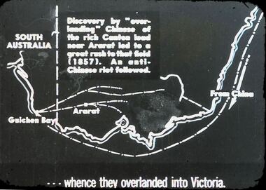
Diggers & Mining. The Chinese on the Gold Fields. Slide reads: Discovery by ''overlanding'' Chinese of the rich canteen load near Ararat led to a great rush to that field (1857). An anti-Chinese riot followed. Slide shows route that the Chinese would have walked. . . . Whence overlanded into Victoria. Markings: 25. Used as a teaching aid.hanimounteducation, tertiary, goldfields -
 Bendigo Historical Society Inc.
Slide - DIGGERS & MINING. THE CHINESE ON THE GOLD FIELDS, c1850s
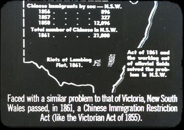
Diggers & Mining. The Chinese on the Gold Fields. Slide: Map of New South Wales. Chinese immigration by sea - N.S.W. 1856 - 896, 1857 - 327, 1858 - 12,096. Total number of Chinese in N.S.W. 1861 - 21,000. Riots of Lambing Flat, 1861. Act of 1861 the working out of alluvial fields solved the problem in N.S.W. Faced with a similar problem to that of Victoria, New South Wales passed, in 1861, a Chinese Immigration Restriction Act (like the Victorian Act of 1855). Markings: 10 994:LIF I. Used as a teaching aid.hanimounteducation, tertiary, goldfields