Showing 1160 items
matching yarra river -- melbourne
-
 Greensborough Historical Society
Map, Melbourne and Metropolitan Board of Works. Survey Division, MMBW, Yarra 2500 / 13.24. Plenty, Memorial Drive, 1979_03
Melbourne and Metropolitan Board of Works. Yarra 2500 [base map] 13-24. Plenty, Memorial Drive. Parish of Morang 3183. Municipalities of Diamond Valley 257 and Whittlesea 239. Prominent streets include: Oatland Road, River Avenue and Memorial Drive. Includes Plenty River and SEC Transmission easement.MMBW Map in 1:2500 [scale] series. Cream parchment with green tape reinforcing on edges and punched holes on left edge.mmbw, melbourne and metropolitan board of works, shire of diamond valley, plenty - maps -
 Greensborough Historical Society
Map, Melbourne and Metropolitan Board of Works. Survey Division, MMBW, Yarra 2500 / 13.26. Yarrambat, Worns Lane, 1978_02
Melbourne and Metropolitan Board of Works. Yarra 2500 [base map] 13.26. Yarrambat, Worns Lane. Municipalities of Diamond Valley 257 and Whittlesea 239. Prominent streets include: Worns Road, North Oatlands Road and Licola Street. Features include Plenty River.MMBW Map in 1:2500 [scale] series. Cream parchment with green tape reinforcing on edges and punched holes on left edge.mmbw, melbourne and metropolitan board of works, shire of diamond valley, whttlesea, yarrambat - maps -
 Greensborough Historical Society
Map, Melbourne and Metropolitan Board of Works. Survey Division, MMBW, Yarra 2500 / 13.23. Plenty, Middle Gorge, 1978_04
Melbourne and Metropolitan Board of Works. Yarra 2500 [base map] 13-23. Plenty / Middle Gorge. Parish of Morang 3183. Municipalities of Diamond Valley 257 and Whittlesea 239. Prominent streets include: Gorge Road, Kurrak Road and Browns Lane. Features include the Plenty River and Plenty Gorge Park.MMBW Map in 1:2500 [scale] series. Cream parchment with green tape reinforcing on edges and punched holes on left edge.mmbw, melbourne and metropolitan board of works, shire of diamond valley, plenty - maps, plenty gorge park -
 Greensborough Historical Society
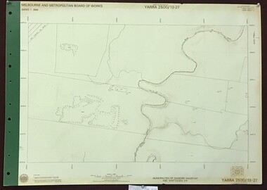
Map, Melbourne and Metropolitan Board of Works. Survey Division, MMBW, Yarra 2500 / 13.27. Morang wetlands, 1977_09
Melbourne and Metropolitan Board of Works. Yarra 2500 [base map] 13.27. Morang wetlands. Municipality of Diamond Valley 257 and Whittlesea 239. Features include the Plenty River and SEC Transmission Line easement. MMBW Map in 1:2500 [scale] series. Cream parchment with green tape reinforcing on edges and punched holes on left edge.mmbw, melbourne and metropolitan board of works, shire of diamond valley, morang - maps -
 Greensborough Historical Society
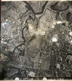
Aerial Photograph, Yan Yean M/S 7922 Run 17 No. 3833-18, 1/11/1984
Covers Viewbank area: North boundary Martin's Lane; South boundary Yarra River & Birrarung Park; East boundary east of Plenty RiverLaminated black and white aerial photograph; adjoins 6227 on west sideviewbank -
 Greensborough Historical Society
Book, Melbourne Water, Plenty River Waterway Management Activity Plan 2000, 2000_
This report covers the catchment of the Plenty River from its upper reaches in the Great Dividing Range to the confluence with the Yarra River at Viewbank. It discusses ecological diversity and methods of improving water quality and significant areas of the catchment. Includes a brief history of settlement along the Plenty River.This is a significant plan for the improvement of the Plenty River.207 p., maps, folding maps. Printed on white paper with black spiral binding and clear plastic front cover.plenty river, melbourne water -
 Greensborough Historical Society
Photograph - Digital image, Outing at Laughing Waters on The Yarra River, 1935, 1935_
Part of a collection of photographs owned by Dorris McLaughlin who was born in Greensborough, in 1899 to John McLaughlin and Rosalie Ellen Whatmough. The collection contains photographs of friends and relatives from the Greensborough and Eltham areas. This photograph shows a large group of people sitting beside the river.Digital copy of black and white photograph.dorris mclaughlin, laughing water -
 Greensborough Historical Society
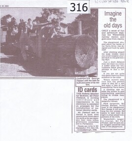
Newspaper clipping, Diamond Valley Leader, Imagine the old days, 10/09/1985
News article relating the opening of a 'gold mining' site and wooden train at Westerfolds Park.Photocopy of article from Diamond Valley News 1985. Includes photograph of children on miniature train.westerfolds park, gold mine, parks, playgrounds, george haslam, yarra river -
 Greensborough Historical Society
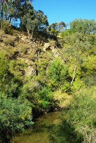
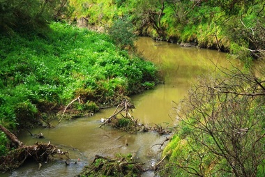
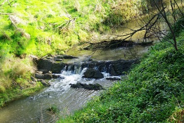
Photograph - Digital Image, Plenty River Greensborough, May 2014 -10, 21/05/2014
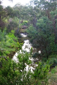
The Plenty River flows south from Mt Disappointment before meeting with the Yarra River at Rosanna. Early settlement in Greensborough was based around the Plenty River. These images were taken in the Greensborough area by Marilyn Smith May 2014.Digital copy of colour photograph.plenty river -
 Greensborough Historical Society
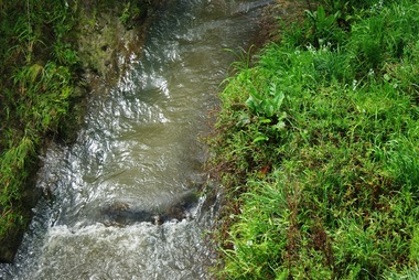
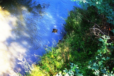
Photograph - Digital Image, Plenty River Greensborough, May 2014 -9, 21/05/2014
The Plenty River flows south from Mt Disappointment before meeting with the Yarra River at Rosanna. Early settlement in Greensborough was based around the Plenty River. These images were taken in the Greensborough area by Marilyn Smith May 2014.Digital copy of colour photograph.plenty river -
 Greensborough Historical Society
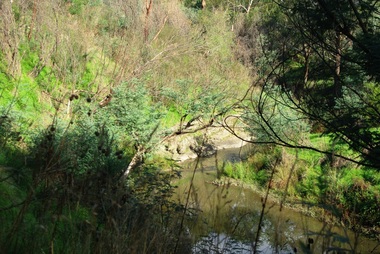
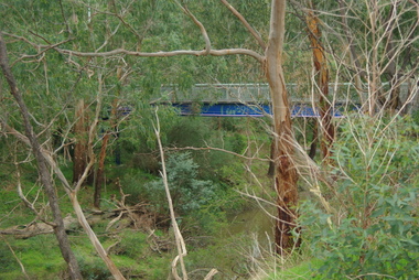
Photograph - Digital Image, Plenty River Greensborough, May 2014 -8, 18/09/2014
The Plenty River flows south from Mt Disappointment before meeting with the Yarra River at Rosanna. Early settlement in Greensborough was based around the Plenty River. These images were taken in the Greensborough area by Marilyn Smith Sept 2014.Digital copy of colour photograph.plenty river -
 Greensborough Historical Society
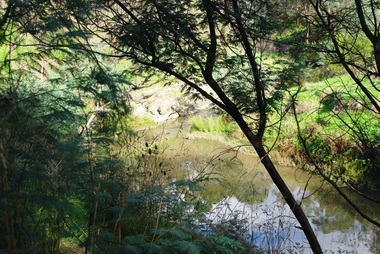
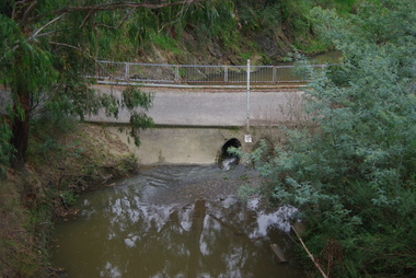
Photograph - Digital Image, Plenty River Greensborough, May 2014 -7, 21/05/2014
The Plenty River flows south from Mt Disappointment before meeting with the Yarra River at Rosanna. Early settlement in Greensborough was based around the Plenty River. These images were taken in the Greensborough area by Marilyn Smith May 2014.Digital copy of colour photograph.plenty river -
 Greensborough Historical Society
Photograph - Digital Image, Plenty River Greensborough, May 2014 -6, 21/05/2014
The Plenty River flows south from Mt Disappointment before meeting with the Yarra River at Rosanna. Early settlement in Greensborough was based around the Plenty River. These images were taken in the Greensborough area by Marilyn Smith May 2014.Digital copy of colour photograph.plenty river -
 Greensborough Historical Society
Photograph - Digital Image, Plenty River Greensborough, May 2014 -5, 21/05/2014
The Plenty River flows south from Mt Disappointment before meeting with the Yarra River at Rosanna. Early settlement in Greensborough was based around the Plenty River. These images were taken in the Greensborough area by Marilyn Smith May 2014.Digital copy of colour photograph.plenty river -
 Greensborough Historical Society
Photograph - Digital Image, Plenty River Greensborough, May 2014 -4, 21/05/2014
The Plenty River flows south from Mt Disappointment before meeting with the Yarra River at Rosanna. Early settlement in Greensborough was based around the Plenty River. These images were taken in the Greensborough area by Marilyn Smith May 2014.Digital copy of colour photograph.plenty river -
 Greensborough Historical Society
Photograph - Digital Image, Plenty River Greensborough, May 2014 -3, 21/05/2014
The Plenty River flows south from Mt Disappointment before meeting with the Yarra River at Rosanna. Early settlement in Greensborough was based around the Plenty River. These images were taken in the Greensborough area by Marilyn Smith May 2014.Digital copy of colour photograph.plenty river -
 Greensborough Historical Society
Photograph - Digital Image, Plenty River Greensborough, May 2014 -2, 21/05/2014
The Plenty River flows south from Mt Disappointment before meeting with the Yarra River at Rosanna. Early settlement in Greensborough was based around the Plenty River. These images were taken in the Greensborough area by Marilyn Smith May 2014.Digital copy of colour photograph.plenty river -
 Greensborough Historical Society
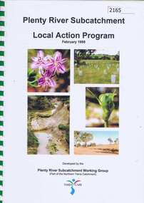
Book, Plenty River Subcatchment: Local Action Plan / Plenty River Subcatchment Working Group, 1999_02
Plenty River Subcatchment Implementation Program was developed to provide information on local catchment management issues and actions to address these issues.44 page book in spiral binding. Col. illus and maps. 2 copies.plenty river, yarra river -
 Greensborough Historical Society
Photograph - Digital Image, Plenty River Greensborough May 2014 -1, 21/05/2014
The Plenty River flows south from Mt Disappointment before meeting with the Yarra River at Rosanna. These images taken in the Greensborough area. Photograph by Marilyn Smith 2014.Digital copy of colour photograph.plenty river, greensborough -
 Greensborough Historical Society
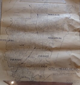
Map, City of Heidelberg. Engineers Dept, City of Heidelberg, 1960s
Map of the City of Heidelberg from the Yarra River in the South to North of Watsonia Military Camp. Shire of Diamond Valley is shown to the north.Map showing municipal and ward boundaries, black text on light brown paper."Scale: 20 CHS = to 1 IN"city of heidelberg -
 Greensborough Historical Society
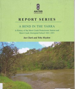
Book, Ian D. Clark et al, A Bend in the Yarra: a history of the Merri Creek protectorate Station and Merri Creek Aboriginal School 1841-1851, by Ian D. Clark and Toby Heydon, 2004_
A history of Aboriginal cultural institutions in colonial Victoria, in this book the interaction between Wurundjeri people and government officials and settlers at the confluence of the Merri Creek and Yarra River.Paperback book, 90 p. black & white illusmerri creek, aborigines victoria -
 Greensborough Historical Society
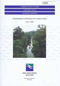
Pamphlet, Lower Plenty River concept plan, summary report: Maroondah Pipetrack to Yarra River, 1992_07
... in Greensborough to where the Plenty meets the Yarra. Melbourne Water ...This draft concept plan covers the lower Plenty River from the Maroondah Pipe track in Greensborough to where the Plenty meets the Yarra. Melbourne Water was the lead agency, assisted by the Shires of Eltham and Diamond Valley, City of Heidelberg, the EPA and Department of Planning and Housing.Coloured pamphlet, photograph and plans 12 pages. 2 copies.plenty river, maroondah aqueduct, melbourne water -
Glenelg Shire Council Cultural Collection
Medal, Centenary of Melbourne 1835 Commemorative Medallion, 1834
White metal medal issued to commemorate Melbourne's centenary 1934-35. This medal was given out to Victorian school children; 325,600 white metal medals were struck. There were also a few VIP pieces in other metals, including two in gold. The medal references Portland, the location of Victoria's first settlement. The Henty brothers, entrepreneur farmers and whalers, established the state's first permanent European settlement in Portland in 1834. Melbourne was established the following year by a party of settlers led by John Batman.White metal medal. Medal, silver. with hole and ring at the top. Obverse: Sailing Ship, Coast, Boat on shore, 3 men. Reverse Colonial man on grass, river, city buildings on other river bank Medal commemorates the centenary of Victoria and Portland 1834 and Melbourne 1835. Obverse:Scene of landing at Portland Bay; in ground below, PORTLAND / 1834; above, centenary of victoria / 1934 Reverse: Pioneer on south bank of Yarra looking across to Melbourne, below 1835 above, CENTENARY / OF / MELBOURNE / 1935Front: Inverse: Centenary of Melbourne 1835 (Top) 1835 (Bottom) Back: Obverse: Centenary of Victoria 1934 (Round Top) Portland 1834 (Bottom)medal, numismatics, celebration, 1834, 1934, 1935, melbourne, portland -
Glenelg Shire Council Cultural Collection
Souvenir - Carmel Wallace's 'Illuminated by Fire' project performance in Melbourne, July 2011, Carmel Wallace, Artist; photo: Grant Wallace, ILLUMINATED BY FIRE, 2011
Printed flyer, Carmel Wallace's 'Illuminated by Fire' project performance in Melbourne, July 2011. Photo of replica New Zealander on Yarra river at night, with fireworks exploding. Reverse has history of project, and sponsors' logos. -
 Greensborough Historical Society
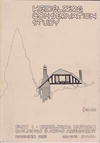
Book, Heidelberg Conservation Study: Part 1 Historic Buildings and Areas Assessment, 1985_
Report prepared by Graeme Butler on behalf of City of Heidelberg and Heidelberg Heritage Advisory Committee. Area covered is from Eaglemont in the south to Macleod in the north.This study identifies neighbourhood character, documents past development and the capacity of the environment for future development.Part one of set of three books. Paperback, 189 pages, Illus., maps. 2 copies.Stamps: Yarra Plenty Regional Library Service, and, Withdrawnheidelberg, macleod, heidelberg heritage advisory committee, graeme butler, plenty river, eaglemont -
 Greensborough Historical Society
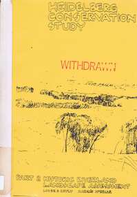
Book, Heidelberg Conservation Study: Part 2: Historic Riverland Landscape Assessment. Revised 1987, 1987_
Report prepared by Loder and Bayly and Marilyn McBriar on behalf of City of Heidelberg and Heidelberg Heritage Advisory Committee. Area covered is from Darebin Parklands in the south to Plenty River at Yallambie in the north. Revised 1987.This study identifies neighbourhood character, documents past development and the capacity of the environment for future development with particular emphasis on the river precincts - Plenty River, Yarra River and Darebin Creek.Part three of set of three books. Paperback, 333 pages, Illus., maps. 2 copies.Stamps: Yarra Plenty Regional Library Service, and, Withdrawnheidelberg, macleod, heidelberg heritage advisory committee, marilyn mcbriar, plenty river, yarra river, darebin creek -
 Greensborough Historical Society
Document, Formation of the Heidelberg School of Painting, 1885-1890
The Heidelberg School of Painting worked in the Yarra Valley area between Box Hill and Heidelberg in the late 19th Century and produced a number of famous artists. This article outlines the history of the School and also lists some paintings.The area in which they worked abuts our area of interest and may have overlapped it in the lower Plenty River area.Foolscap double sided typed document of 6 pages; includes list of paintings..Blue biro word on front page, "Fraser"heidelberg, yarra river, walter withers, heidelberg school of painting, australian art. -
 Eltham District Historical Society Inc
Photograph, Upper Yarra Dam, Spring Tour, 22 Oct 1995, 22/10/1995
EXPLORING THE UPPER YARRA (Newsletter No. 105, November 1995, by Bettina Woodburn) We enjoyed the Spring Excursion, this year "Exploring the Upper Yarra" - in spite of the constant rain and the countryside under the cloud cover, especially in the valleys, being mainly shiny shades of green. The occasional fields of buttercups, clumps of arum lilies and splendid rhododendron and other flowering bushes became very special. The Cobb and Co coach was warm and a cosy retreat as we zig-zagged on the highways and byways to glimpse the Yarra River, upstream and down, its secret places, and particularly the many bridges. Russell excelled as 'Poet Laureate', reading from Dacre Smyth's book. This 1979 publication includes paintings of all the bridges along the river with poems and brief descriptions of each one. Some of the bridges are in out of the way places and are not very well known. We looked forward to hearing the poetry as much as seeing the ' constructions'…Big Pat (was he short or tall, lean or fat? He did win the two hundred pound reward for discovering gold and had the creek named after him), about the 'Eddies'?, and the disliked 'meccano' bridge in Warburton, etc. etc. The hot roast lunch in the old Reefton Hotel was also most welcome. It was easy to imagine it peopled by miners and early settlers. Starting by crossing the new (1974) concrete bridge at Warrandyte we headed through Wonga Park with views to the Christmas Hills and to the escarpment of the Yering Gorge, which causes flood waters to back up through the Yarra Glen plain, so avoiding disasters downstream. At the end of a long driveway we found the wooden, privately owned Henley Bridge (1935 after the 1934 floods). This facilitates access to different parts of Henley Farm and to Lilydale. Everard Park, named after Blanche Shallard's father, a State Member for 17 years, below the Highway Yarra crossing was in need of care. It is 10 miles from Yarra Glen by road but, as "Yarra Marra” canoeists well know, 32 winding miles down by water. After more delightful countryside scenes we joined the Warburton Highway at Woori Yallock. From the old Railway Station at Launching Place the Centennial Trail for walkers, cyclists and ' horse riders has replaced the rails. The line from Lilydale was opened in 1901, and the last diesel freight train ran to Warburton in 1965. It continued to rain as we had morning tea in Warburton in a shelter between footbridges. From here we continued upstream past the Bridge to O'Shannasy Lodge and Reservoir, Starvation Creek, and the Peninsular tunnel (miners dug it as at Pound Bend) which we visited (scrambling down those steps!) on our return after lunch. Our furthermost point was the Upper Yarra Dam Reserve (and vast catchment area). Finished in 1957 after ten years work and 100 years after Yan Yean, it supplies much of Melbourne's water. After crossing the 30m Launching Place Bridge to the Eltham side of the Yarra and Healesville, we saw in the distance the Yarra Glen Timber Trestle Bridge over the river flats "the longest for years in the land it was said!" Harry's dream of "better weather over the Divide" unfortunately didn't come true, but I'm sure we 36 members will retain happy memories of a day that was wet and green and filled with Bridges. Bettina Woodburn - October 1995 Record of the Society's history of activities - Spring 1995 excursionRoll of 35mm colour negative film, 3 stripsKodak Gold 200-4shire of eltham historical society, activities, upper yarra dam, henley bridge -
 Eltham District Historical Society Inc
Photograph, Upper Yarra Dam, Spring Tour, 22 Oct 1995, 22/10/1995
EXPLORING THE UPPER YARRA (Newsletter No. 105, November 1995, by Bettina Woodburn) We enjoyed the Spring Excursion, this year "Exploring the Upper Yarra" - in spite of the constant rain and the countryside under the cloud cover, especially in the valleys, being mainly shiny shades of green. The occasional fields of buttercups, clumps of arum lilies and splendid rhododendron and other flowering bushes became very special. The Cobb and Co coach was warm and a cosy retreat as we zig-zagged on the highways and byways to glimpse the Yarra River, upstream and down, its secret places, and particularly the many bridges. Russell excelled as 'Poet Laureate', reading from Dacre Smyth's book. This 1979 publication includes paintings of all the bridges along the river with poems and brief descriptions of each one. Some of the bridges are in out of the way places and are not very well known. We looked forward to hearing the poetry as much as seeing the ' constructions'…Big Pat (was he short or tall, lean or fat? He did win the two hundred pound reward for discovering gold and had the creek named after him), about the 'Eddies'?, and the disliked 'meccano' bridge in Warburton, etc. etc. The hot roast lunch in the old Reefton Hotel was also most welcome. It was easy to imagine it peopled by miners and early settlers. Starting by crossing the new (1974) concrete bridge at Warrandyte we headed through Wonga Park with views to the Christmas Hills and to the escarpment of the Yering Gorge, which causes flood waters to back up through the Yarra Glen plain, so avoiding disasters downstream. At the end of a long driveway we found the wooden, privately owned Henley Bridge (1935 after the 1934 floods). This facilitates access to different parts of Henley Farm and to Lilydale. Everard Park, named after Blanche Shallard's father, a State Member for 17 years, below the Highway Yarra crossing was in need of care. It is 10 miles from Yarra Glen by road but, as "Yarra Marra” canoeists well know, 32 winding miles down by water. After more delightful countryside scenes we joined the Warburton Highway at Woori Yallock. From the old Railway Station at Launching Place the Centennial Trail for walkers, cyclists and ' horse riders has replaced the rails. The line from Lilydale was opened in 1901, and the last diesel freight train ran to Warburton in 1965. It continued to rain as we had morning tea in Warburton in a shelter between footbridges. From here we continued upstream past the Bridge to O'Shannasy Lodge and Reservoir, Starvation Creek, and the Peninsular tunnel (miners dug it as at Pound Bend) which we visited (scrambling down those steps!) on our return after lunch. Our furthermost point was the Upper Yarra Dam Reserve (and vast catchment area). Finished in 1957 after ten years work and 100 years after Yan Yean, it supplies much of Melbourne's water. After crossing the 30m Launching Place Bridge to the Eltham side of the Yarra and Healesville, we saw in the distance the Yarra Glen Timber Trestle Bridge over the river flats "the longest for years in the land it was said!" Harry's dream of "better weather over the Divide" unfortunately didn't come true, but I'm sure we 36 members will retain happy memories of a day that was wet and green and filled with Bridges. Bettina Woodburn - October 1995 Record of the Society's history of activities - Spring 1995 excursionRoll of 35mm colour negative film, 3 stripsKodak Gold 200-4shire of eltham historical society, activities, upper yarra dam, henley bridge