Showing 178929 items
matching streets
-
 Bendigo Historical Society Inc.
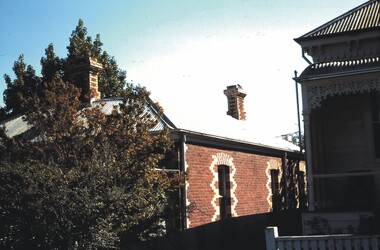
Slide - ALLAN BUDGE COLLECTION: SLIDE CORNER ARTHUR & KING STREETS, 1988
Slide, ALLAN BUDGE COLLECTION, Polychome Brickwork, Cnr Arthur & King Streets. Side view from Arthur Street but very attractive.house, public, allan budge collection, allan budge collection -
 Bendigo Historical Society Inc.
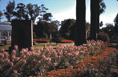
Slide - CHS, CONSERVATORY GARDENS, BRIDGE STREET, BENDIGO, 1979
Slide. CHS, Conservatory Gardens, Bridge Street, Bendigo. View of the Conservatory Gardens from the corner of Bull and Bridge streets. Date: 7.4.79slide, bendigo, conservatory gardens bendigo, slide chs, conservatory gardens, bridge street, bendigo 1979 -
 Tatura Irrigation & Wartime Camps Museum
Photograph, Tatura Bird's Eye
Bird's eye view of Tatura; features Criterion Hotel, Hogan Street, Hogan Street Railway Crossing, Horse-drawn cart, fences.tatura, buildings, historic, transport, railway, horse -
Lakes Entrance Regional Historical Society (operating as Lakes Entrance History Centre & Museum)
Photograph, Purch, 1/09/1975 12:00:00 AM
Also a second colour photograph taken from similar position at same event 05166.1 10 x 15 cmColour photograph of Pony Club entries in Lakes Alive festival street parade at the Eastern end of Roadknight Street Lakes Entrance Victoriarecreation, festival -
 Clunes Museum
Photograph
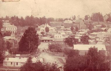
POSTCARD SENT TO MRS. MC LENNAN, MARLBOROUGH, ROCKHAMPTON, QUEENSLAND FROM E.M.S.POSTCARD - OVERVIEW OF CLUNES - TAKEN FROM TOP OF CAMERON STREET HILL - SHOWING FRASER AND SERVICE STREET CORNER, SHOPS AND BUILDINGS. =1159Addressed to Mrs. L. McLennan Olive Marlborough Rockhampton Queensland Message With best wishes for a happy New Year E.M.S.local history, document, postcard, clunes township -
Clunes Museum
Photograph, PHOTOGRAPHER - RON DOWNES, CLUNES, 2004
THIS PHOTOGRAPH WON FIRST PRIZE IN THE PHOTOGRAPHIC SECTION OF THE CLUNES AGRICULTURAL SHOW 2004, SPONSERED BY THE CLUNES MUSEUM.COLOURED PHOTOGRAPH OF FRASER STREET, SHOWING FORMER STATE SAVINGS BANK, R.S.L. CLUBROOMS, CLUB HOTEL AND MUSEUM, ON SOUTH SIDE OF STREET.local history, photography, photographs, buildings -
Whitehorse Historical Society Inc.
Article, Basin not the answer, claims flooding victim, 1993
A retarding basin in Scott Street, Vermont is proposed to prevent flooding in Barbara Street, but former resident, Ms Daly is sceptical of its efficiency.A retarding basin in Scott Street, Vermont is proposed to prevent flooding in Barbara Street, but former resident, Ms Daly is sceptical of its efficiency.A retarding basin in Scott Street, Vermont is proposed to prevent flooding in Barbara Street, but former resident, Ms Daly is sceptical of its efficiency.city of nunawading., barbara street, vermont, scott street, vermont, daly, belinda, ward, kelvin -
 Whitehorse Historical Society Inc.
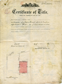
Legal record - Document, Certificate of Title - Scott, 14/04/1915 12:00:00 AM
Certificate of Title dated 14/4/1915 in the name of Emma Elizabeth Scott.Certificate of Title dated 14/4/1915 in the name of Emma Elizabeth Scott. Land bounded by Victoria Street and Scott Street, MitchamCertificate of Title dated 14/4/1915 in the name of Emma Elizabeth Scott.land titles, scott, emma elizabeth, scott street, mitcham, victoria street -
Whitehorse Historical Society Inc.
Article, Mitcham plan under way, 1986
Article stating that Edward Street, Mitcham will be closed for redevelopment of Mitcham Shopping Centre and the removal of the Guide Hall in Britannia Street to Halliday Park.Article stating that Edward Street, Mitcham will be closed for redevelopment of Mitcham Shopping Centre and the removal of the Guide Hall in Britannia Street to Halliday Park.Article stating that Edward Street, Mitcham will be closed for redevelopment of Mitcham Shopping Centre and the removal of the Guide Hall in Britannia Street to Halliday Park.edward street, mitcham, mitcham shopping centre, mitcham guides, britannia street, halliday park -
 Whitehorse Historical Society Inc.
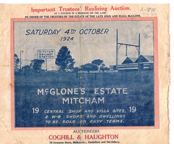
Document, McGlone Estate Mitcham
Pamphlet on auction of McGlone's Estate,Pamphlet on auction of McGlone's Estate, Mitcham 1924. Bordered by McGlone Street, Whitehorse Road, Station Street and Mitcham Railway line and stationPamphlet on auction of McGlone's Estate, land sales, auctions, mcglone estate, mcglone, john, elizabeth, station street, mitcham, whitehorse road, mitcham railway station, coghill & haughton -
 Whitehorse Historical Society Inc.
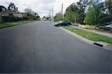
Photograph, Victoria Street, Mitcham, 1/10/2000 12:00:00 AM
Coloured photograph of of Victoria Street looking east. Car is exiting from multi storey car park in Edward Street into Victoria Avenue.victoria street, mitcham -
 Whitehorse Historical Society Inc.
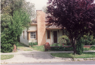
Photograph, 8 Edward Street, Mitcham, 1991
Coloured photo - 8 Edward Street, Mitcham. Demolished 1991 and replaced as one of a pair of semi-detached dwellings with No. 10 Edward Street.edward street, mitcham -
 8th/13th Victorian Mounted Rifles Regimental Collection
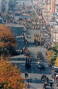
Photograph
Colour photograph of Anzac Day March in Dean Street Albury,1994.Photographer positioned in elevated position at western end of Dean Street. -
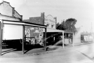 Surrey Hills Historical Society Collection
Photograph, Hamilton Street, Mont Albert in 1919, 1919
The land occupied by the Hamilton Street shops was subdivided in the 1880s and the first purpose-built shop was 'Pope and Moran, Grocers'. This shop later became Tom Morris' Grocery. By 1930 shops stretched along both sides of Hamilton Street and part way along Churchill Street. The donor the late Norman Carter took many photos documenting Mont Albert and Surrey Hills from the 1920s. His subject matter often related to Church of England events and activities.Black and white photo taken from the centre of the road in Hamilton Street, Mont Albert. Three single storey shops can be seen with vacant blocks of land in between them. They have verandas extending over the pavement to the edge of the road which appears to have bluestone curb and channelling. One shop sells dairy produce and small goods.hamilton street, shops -
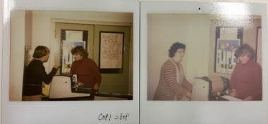 Kew Historical Society Inc
Photograph - 'Copy Shop', Old Masonic Hall, Walpole Street, 1970s
The 'Copy Shop' in Walpole Street, Kew was located in the former Masonic Hall. It was a community operated facility. The 'shop' was designed for use by groups to run off leaflets or newsletters. It also served as a community space where people could drop in for a coffee and leave leaflets and information about events in the City of Kew. Two polaroid photographs, Thea Sartori in a red jumper is in both photographs. The woman in the pink cardigan is Aileen Cahill. Both photos were taken at the 'Copy Shop' in the old Masonic Hall [demolished] in Walpole Street. front: "Copy Shop"copy shop - walpole street - kew (vic), community facilities -- city of kew, masonic hall -- kew (vic.) -
 Kew Historical Society Inc
Plan - Subdivision Plan, Normanby Estate, East Kew, 1913
Pru Sanderson, in her groundbreaking ‘City of Kew Urban Conservation Study : Volume 2 - Development History’ (1988), summarised the periods of urban development and subdivisions of land in Kew. The periods that she identified included 1845-1880, 1880-1893, 1893-1921, 1921-1933, 1933-1943, and Post-War Development. These periods were selected as they represented periods of rapid growth or decline in urban development. An obvious starting point for Sanderson’s groupings involved population growth and the associated economic cycles. These cycles also highlighted urban expansion onto land that was predominantly rural, although in other cases it represented the decline and breakup of large estates. A number of the plans in the Kew Historical Society’s collection can also be found in other collections, such as those of the State Library of Victoria and the Boroondara Library Service. A number are however unique to the collection.The Kew Historical Society collection includes almost 100 subdivision plans pertaining to suburbs of the City of Melbourne. Most of these are of Kew, Kew East or Studley Park, although a smaller number are plans of Camberwell, Deepdene, Balwyn and Hawthorn. It is believed that the majority of the plans were gifted to the Society by persons connected with the real estate firm - J. R. Mathers and McMillan, 136 Cotham Road, Kew. The Plans in the collection are rarely in pristine form, being working plans on which the agent would write notes and record lots sold and the prices of these. The subdivision plans are historically significant examples of the growth of urban Melbourne from the beginning of the 20th Century up until the 1980s. A number of the plans are double-sided and often include a photograph on the reverse. The Normanby Estate, which was adjacent to Normanby Road, Kew East, included thirty-one lots for sale. Streets on the subdivision plan include Adeney Avenue, Park Hill Road, Normanby Road, Weir Street and Wharton Street. Cotham Road and its tramway are shown nearby. The plan is interesting as it shows Wharton Street, named after the architect and town planner George Wharton, who was the first chairman of the Municipality of Kew. The street was to later be renamed Cecil Street. Also shown are proposed ‘Municipal Gardens’ where Parkhill Drive is now located.subdivision plans - kew, normanby estate -
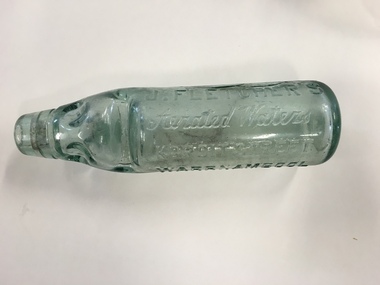 Warrnambool and District Historical Society Inc.
Bottle, J Fletcher's aerated waters, Circa 1900
The making of cordials and aerated waters was an important industry in Warrnambool from the time of the first settlement up to the 1980s. John Fletcher succeeded John Davis in Koroit Street in 1885 and manufactured aerated waters, soda, lithia, tonic waters, lemonade, ginger ale, hop beer, hop bitters, sarsparilla and cordials. He installed many improvements around the late 1880's including an improved soda water machine which was also used for bottling lemonade, ginger ale and syphons. He sold to Ralph Reeves in 1930 and the business continued until the 1980's under the name of Reeves. The premises in Koroit St were auctioned in 1989.Warrnambool cordial bottles are of considerable significance as examples of an important local industry now gone. The Fletcher business was a well-known business in Warrnambool for 45 years.Round bottle with raised lettering in glass and indented sections on top section of bottle with marble enclosed. Clear greenish glass.J Fletcher’s Aerated waters Koroit Street Warrnambool vertically on bottle with lemonade horizontally on the other side. M on bottom of bottle.warrnambool,fletcher's aerated waters, fletcher's cordial , cordial bottle, -
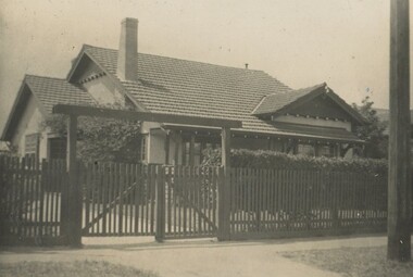 Surrey Hills Historical Society Collection
Photograph, Sister Ann Elizabeth Dowsley's home in Elgar Road, Box Hill, c1939
This was the home of Sister Ann Elizabeth Dowsley, daughter of Thomas Dowsley and Mary McKay. She was born in St Arnaud in 1887. She enlisted on 22 August 1916. As a AANS Matron in WW1 she served in India. She was awarded a Royal Red Cross award for conspicuous services. She did not marry. She died in December 1960 at Caulfield. There is a photo of her in Punch, Thursday 31 August, 1916, p 21. REF: Laurie Newton - Ernest Lance Young and Beryl (nee Mair) bought the house from Sister Dowsley for £895 on their marriage in 1939 but sold it when Lance was sent to Darwin during his war service. Beryl purchased 11 York Street in later war years. This property was also significant for Ernest Lance Young and Beryl Mair. It may have been the childhood home of their children Barbara and Ken, but Laurie was probably born after they moved to York Street. Lance was born 24 March 1915 in Surrey Hills, the son of Ernest Augustus Young and Ruby Nichell Whitby. He married Beryl Mair in 1939 and died on 5 October 1999 at Mont Albert. Electoral rolls list him as a manufacturer. He is buried in Box Hill Cemetery (M-*-0867) along with his father. He served in WW2 (Service Number - VX104733 enlisting at St Kilda) and after returning took over his father's business. The Mair family were resident in Barton Street for several generations. Beryl's father Dave Mair was a keen sportsman and founder of the Kangaroo Social Club of cricketers. This is part of a large collection relating to the Mair, Deakin and Young families. Black & white photo of the street view of a Californian bungalow home set behind a picket fence and hedge. The house appears to be weatherboard and render with a terracotta tile roof and a simple chimney.In blue biro on rear: "Our first home", "Sister Dowsleys home at / Elgar Rd B Hill"; "YOUNG" In lead pencil on rear: " 3 (pound symbol) 895" Photographic processing stamps "14" and (?) "GRANVILLE PRINT" within a triangle. ann elizabeth dowsley, world war 1, nurse, elgar road, ernest lance young, beryl young, beryl mair -
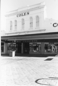 Stawell Historical Society Inc
Photograph, G. J. Coles Shop at 113 Main Street Stawell -- Different Angle
Shop 113 Main Street Stawell once Coles retail store now Lyal Eales. Coles store operated around 1984, 1991. Lyal Eales opened in 2013.A different view of the Coles retail store when the street was turned into a mall, as the photo shows a brick pavement in front of the building. The entrance area between two display windows with a third display windows to the right. The upper level has 5 arch shaped windows.COLESg. j. coles retail shop stawell -
Glenelg Shire Council Cultural Collection
Photograph - Copy of Photograph - Percy Street, Portland, Victoria, 1859
Vern Mc Callum CollectionDigital copy of monochrome photo taken in Portland in 1859. View of west side of Percy Street between Tyers and Henty Street. Several men standing on footpath. Man in horse and buggy. Another horse and buggy staning empty in street. -
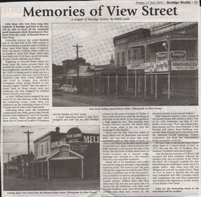 Bendigo Historical Society Inc.
Newspaper - JENNY FOLEY COLLECTION: MEMORIES OF VIEW STREEET
Bendigo Weekly, Friday 27, July 2001. Memories of View Street - a snippet of Bendigo history, by Edith Lunn - An article describing the small businesses that flourished in View Street from the corner of Barnard Street to View point. The clip is in a folder.newspaper, bendigo, bendigo weekly -
Port Melbourne Historical & Preservation Society
Photograph - 41 to 71 Evans Street, Port Melbourne, Meredith Turnbull, Dec 1996
Meredith Turnbull photographed this series in 1996 to record the rapidly changing streetscape, which had already had a number of old houses replaced by concrete two-storey structures under the State government's urban consolidation policyFrom a series of 70 colour photos recording all buildings in Evans Street from Graham Street overpass to Ingles Street, as photographed from the railway reservation, by Meredith Turnbull in December 1996 - wider view of numbers 41 to 71House numbers noted on backbuilt environment - domestic, meredith turnbull -
Port Melbourne Historical & Preservation Society
Photograph - 52 Evans Street, Port Melbourne, Meredith Turnbull, Dec 1996
Meredith Turnbull photographed this series in 1996 to record the rapidly changing streetscape, which had already had a number of old houses replaced by concrete two-storey structures under the State government's urban consolidation policyFrom a series of 70 colour photos recording all buildings in Evans Street from Graham Street overpass to Ingles Street, as photographed from the railway reservation, by Meredith Turnbull in December 1996 - number 52 'Tring Cottage' closeupHouse numbers noted on backbuilt environment - domestic, meredith turnbull -
Port Melbourne Historical & Preservation Society
Photograph - 127 & 128 Evans Street, Port Melbourne, Meredith Turnbull, Dec 1996
Meredith Turnbull photographed this series in 1996 to record the rapidly changing streetscape, which had already had a number of old houses replaced by concrete two-storey structures under the State government's urban consolidation policyFrom a series of 70 colour photos recording all buildings in Evans Street from Graham Street overpass to Ingles Street, as photographed from the railway reservation, by Meredith Turnbull in December 1996 - number 127, 128 close-upHouse numbers noted on backbuilt environment - domestic, meredith turnbull -
Port Melbourne Historical & Preservation Society
Photograph - Turner Family home, 190 Nott Street (renumbered as 114 Nott Street), Port Melbourne, 1940s
B&W lasercopy, one of four on a page of photos of Bert Turner family home, 190 Nott Street: 114 Nott Street in the 1980s. (Nott Street numbers have changed; see also item 914 re furnishings)built environment - domestic, bert turner -
Port Melbourne Historical & Preservation Society
Photograph - 8, 9 & 11 Evans Street, Port Melbourne, Meredith Turnbull, Dec 1996
Meredith Turnbull photographed this series in 1996 to record the rapidly changing streetscape, which had already had a number of old houses replaced by concrete two-storey structures under the State government's urban consolidation policyFrom a series of 70 colour photos recording all buildings in Evans Street from Graham Street overpass to Ingles Street, as photographed from the railway reservation, by Meredith Turnbull in December 1996 - number 8, 9, 11 EvansHouse numbers noted on backbuilt environment - domestic, meredith turnbull -
Port Melbourne Historical & Preservation Society
Photograph - 43, 44, 45 & 46 Evans Street, Port Melbourne, Meredith Turnbull, Dec 1996
Meredith Turnbull photographed this series in 1996 to record the rapidly changing streetscape, which had already had a number of old houses replaced by concrete two-storey structures under the State government's urban consolidation policyFrom a series of 70 colour photos recording all buildings in Evans Street from Graham Street overpass to Ingles Street, as photographed from the railway reservation, by Meredith Turnbull in December 1996 - number 43, 44, 45, 46House numbers noted on backbuilt environment - domestic, meredith turnbull -
Port Melbourne Historical & Preservation Society
Photograph - Lily Cottage, 77 Evans Street, Port Melbourne, Meredith Turnbull, Dec 1996
Meredith Turnbull photographed this series in 1996 to record the rapidly changing streetscape, which had already had a number of old houses replaced by concrete two-storey structures under the State government's urban consolidation policyFrom a series of 70 colour photos recording all buildings in Evans Street from Graham Street overpass to Ingles Street, as photographed from the railway reservation, by Meredith Turnbull in December 1996 - two of number 77 (Lily Cottage)House numbers noted on backbuilt environment - domestic, meredith turnbull -
Port Melbourne Historical & Preservation Society
Photograph - 125, 126, 127 & 128 Evans Street, Port Melbourne, Meredith Turnbull, Dec 1996
Meredith Turnbull photographed this series in 1996 to record the rapidly changing streetscape, which had already had a number of old houses replaced by concrete two-storey structures under the State government's urban consolidation policyFrom a series of 70 colour photos recording all buildings in Evans Street from Graham Street overpass to Ingles Street, as photographed from the railway reservation, by Meredith Turnbull in December 1996 - number 125, 126, 127, 128House numbers noted on backbuilt environment - domestic, meredith turnbull -
Port Melbourne Historical & Preservation Society
Photograph - 151, 152, 153 & 154 Evans Street, Port Melbourne, Meredith Turnbull, Dec 1996
Meredith Turnbull photographed this series in 1996 to record the rapidly changing streetscape, which had already had a number of old houses replaced by concrete two-storey structures under the State government's urban consolidation policyFrom a series of 70 colour photos recording all buildings in Evans Street from Graham Street overpass to Ingles Street, as photographed from the railway reservation, by Meredith Turnbull in December 1996 - number 151, 152, 153, 154House numbers noted on backbuilt environment - domestic, meredith turnbull