Showing 7078 items
matching snowy-river
-
 Bendigo Historical Society Inc.
Map - CAMPBELL COLLECTION: BENDIGO AND DISTRICT MAPS
Map. Kimbolton, Parishes of Kimbolton and Lyell, scale 20 chains to 1 inch. Area by Planimeter 6258 acres. Knowsley. 10 1/2 miles to Strathfieldsaye. Campaspe River at bottom right of map. (number 365 in map cupboard 1)map, bendigo, allotments -
 Bendigo Historical Society Inc.
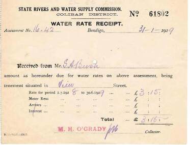
Document - BUSH COLLECTION: RECEIPTS AND NOTICES FOR THE PROVISION OF SERVICES, 1920 - 1930
Collection of approximately 22 receipts and notices pertaining to S. A. Bush. Includes documents from Bendigo Sewerage Authority, State Rivers and Water Supply Commission, Bendigo Gas Company, Plus Dividend Notices from The Colonial Gas Association Limited.person, individual, bush collection - personal -
 Port Melbourne Historical & Preservation Society
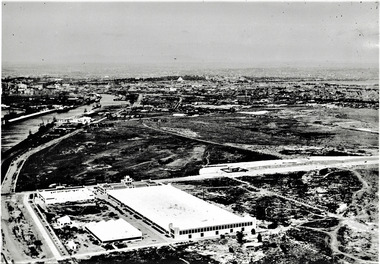
Photograph - Aerial view of Fisherman's Bend circa 1940, circa1940
From the collection of Terry KEENAN. The 9 hole golf course known as the Sandridge Golf Club was part of Victorian Golf Clubs until it moved to Cheltenham in 1927. Trotting 'Speedway' located at top right of photograph.Black and white photograph of Fishermans Bend, Port Melbourne, c. 1940 showing General Motors Holden in the foreground. The original home of the Victoria Golf Club is shown on the left beside the Yarra River winding towards the city & North & South Wharves. built environment, fishermans bend, built environment - industrial, general motors-holden, victoria golf club, sport - golf, sport - horse racing -
 Bendigo Historical Society Inc.
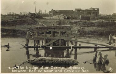
Postcard - ACC LOCK COLLECTION: THE BRIDGE AFTER GERMAN OFFENSIVE BETWEEN BAC ST. MAUR AND CROIX DU BAC, POSTCARD, 1914-1918
Postcard, WW1, B&W image of a ruined wooden bridge over a river between Bac St. Maur and Croix du Bac, after a German offensive. Two piles of timber in front of a damaged building in background. Copy Z 27postcard, postcard, ww1, bac st.maur, croix du bac, france -
 Sunshine and District Historical Society Incorporated
Map (1967), CITY OF SUNSHINE, June 1967, 1967
The City of Sunshine no longer exists. Part of the eastern area has been annexed by the City of Maribyrnong, and the rest of the old City of Sunshine has been amalgamated with the City of Keilor to form the larger City of Brimbank.This 1967 map is a historical record of the City of Sunshine as it existed 27 years before the amalgamation of Councils, and the creation of the City of Brimbank in 1994.Whitish paper map with black printing that is laminated in clear plastic film, and has a wood slat attached to the top edge. The June 1967 map is of the previous CITY OF SUNSHINE showing City and Parish boundaries, streets, railways, creeks, river etc.Purple ink stamps at top left hand and right hand areas showing address and contact details of 'Sunshine Industrial Promotion Centre.'city of sunshine, june 1967, map, city, parish, boundaries, brimbank -
 Whitehorse Historical Society Inc.
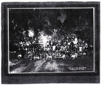
Photograph, Methodist Sunday School, 3/11/1931 12:00:00 AM
Mitcham Methodist Sunday School Picnic taken 3 November 1931,at what is now Whitefriars College, Donvale. Methodist Sunday School picnic was an annual affair until the mid-1950's to either Seaford beach or the Yarra River at Warrandyte.methodist church mitcham -
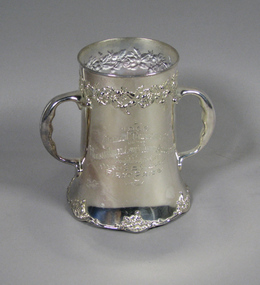 Tennis Australia
Prize cup, 1906
Silver-plated tankard inscribed: '1906/ANNUAL TOURNAMENT/OF THE HUDSON RIVER LAWN TENNIS ASSOCIATION/POUGHKEEPSIE, N.Y./MEN'S DOUBLES/FIRST PRIZE/WON BY'. Stamped on base: 'DERBY SILVER CO/QUADRUPLE PLATE/459'. Materials: Silver/Metaltennis -
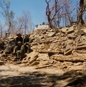 8th/13th Victorian Mounted Rifles Regimental Collection
Photograph
In 1988, as part of a Defence of Mainland Australian policy, defence of facilities of strategic importance in northern Australia were allocated to Army Reserve units. ‘A’ Squadron was allocated the defence of Tindal Air Force base located 15 KM outside Katherine in Northern Territory. Consequently the Squadron deployed on Exercise ‘Northern Explorer’ to gain first-hand knowledge of operating conditions for mounted and dismounted patrolling in the area.Colour photograph of vehicle patrol of ' A " Squadron 8/13 VMR accessing the viability of a crossing point of Ferguson River during Exercise ' Northern Explorer. The patrol decided the Armoured Personnel carrier could descend the shale bank but not climb out again. -
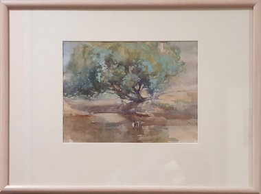 Federation University Art Collection
Painting - Watercolour, McGeorge, Norman, Untitled, c mid 1940s
Norman MacGEORGE (08 July 1872– 2 September 1952) Born Adelaide, South Australia Norman Macgeorge taught drawing at Wesley College, Melbourne from 1902-06. He also taught at Melbourne Teachers' College and at Melbourne Church of England Grammar School. This item is part of the Federation University Art Collection. The Art Collection features over 2000 works and was listed as a 'Ballarat Treasure' in 2007.Framed landscape depicting the confluence of the Darebin Creek and the Yarra River. Purchased by the Ballarat Teachers' College in 1964. This work was exhibited in "Norman MacGeorge: Man of Art" at the Ian Potter Museum of Art, The University of Melbourne, 22 September to 25 November 2001.art, artwork, norman mcgeorge, mcgeorge, watercolour, available, landscape, darebin creek, yarra river, ballarat teachers' college art collection -
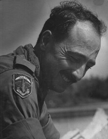 National Vietnam Veterans Museum (NVVM)
Photograph, Gibbons, Denis, AATTV Major
Denis Gibbons (1937 – 2011) Trained with the Australian Army, before travelling to Vietnam in January 1966, Denis stayed with the 1st Australian Task Force in Nui Dat working as a photographer. For almost five years Gibbons toured with nine Australian infantry battalions, posting compelling war images from within many combat zones before being flown out in late November 1970 after sustaining injuries. The images held within the National Vietnam Veterans Museum make up the Gibbons Collection.A black and white photograph of Hue, 1 Corps, South Vietnam 1969. An Australian Army Training Team Vietnam (AATTV) Major looks relaxed as he is paddled up the Perfume River, by members of his unit stationed North West of Hue.photograph, hue, perfume river, 1 corps, aattv, gibbons collection catalogue, denis gibbons, photographer, vietnam war, australian army training team vietnam (aattv), major -
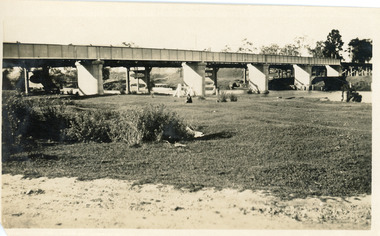 Lakes Entrance Historical Society
Photograph - Bridges, 1925
Black and white photograph showing rail bridge across Mitchell River. Photograph shows side of rail bridge on south side, trees top right hand corner. Left hand side of photograph shows the road bridge. Bairnsdale, Victoriabridges, waterways -
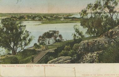 Bendigo Historical Society Inc.
Postcard - Alice McGregor Postcard Collection, 1900 - 1920
Alice McGREGOR Born: 1908; unknown parents. Possibly adopted by the Salter family? Electoral Roll 1936: Highland Terrace Kangaroo Flat. Alice Mary Salter and William Robert Salter living together; presumed to be sister and brother. William Robert Salter was killed in a MVA in Bendigo in 1937 aged 26. In Victoria in 1938, Alice Mary Salter married James Thomas McGregor (born Victoria 1917, died Victoria 1983, buried Fawkner Cemetery) Lived: 1968; 22 Wade Street Golden Square Alice McGregor Died: 1999 aged 91 at Anne Caudle Centre, Bendigo Buried: Kangaroo Flat Cemetery See additional research. Postcard Album of Alice McGregor contained 86 post cards.Postcard Album of Alice McGregor containing 86 post cards. See 1400. Colour photo of The Lower Terrace, King's Park, Perth. W.A. Swan river in middle ground, man standing at bottom of steps. Early years of Perth in background Addressed to Miss A. Stapleton, Arcade, Bendigo, Victoria Sender not given Undated postcard, collector, alice mcgregor -
Lakes Entrance Historical Society
Book, Commonwealth of Australia, Division of Gippsland. Roll of electors for the subdivision of Cunninghame.1905, 1905
Alphabetical list of persons on the electoral roll for Cunninghame, Division of Gippsland in 1905. Gives name, sex, place of living and occupation. Also electoral roll for 1912 also 1985 Orbost Shire rates people living in Reeves River .estimated populdirectories -
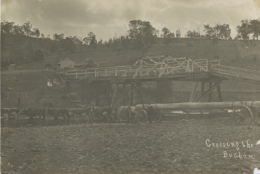 Lakes Entrance Historical Society
Photograph, John Flynn, Crossing the Buchan, 1906
Bridge was built in 1896 and never finishedBlack and white photograph of bullock team pulling timber jinker with very long logs across the Buchan River beside the footbridge. Several men in charge of team and four girls on the hill, cottage and barn seen, bridge not finished Buchan VictoriaCrossing the Buchantransport, waterways, bridges, people -
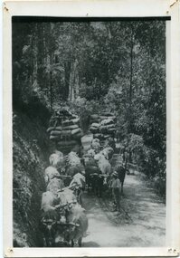 Orbost & District Historical Society
black and white photograph, late 19th - early 20th century
This is a photograph of bullock teams on the Cann Road. out of Cann River, East Gippsland.This is a pictorial record of transport in the mid 18th - early 19th century. Bullock teams could travel in country inaccessible to larger horse - drawn carts or wagon.A black / white photograph of two bullock teams travelling side by side along a bush road.transport-bullocks cann-river -
 Marysville & District Historical Society
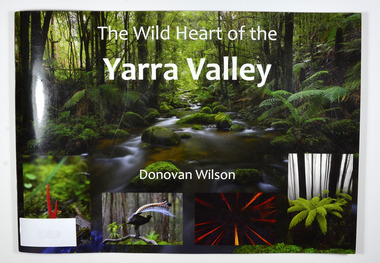
Book, The Wild Heart of the Yarra Valley
A pictorial book of the flora, fauna, rivers, waterfalls and rainforest in the Upper Yarra ValleyPaperback. Front cover has a main photograph of a creek running through a forest. There is also four smaller photographs. They are of a Red Coral Fungi, a Superb Lyrebird, a night time view looking upwards in a grove of trees and a view of a Soft tree fern. The back cover has a photograph of a Superb Lyrebird.yarra valley, upper yarra valley, flora, fauna, photography, rivers, waterfalls, rainforest, nature, donovan wilson -
 Marysville & District Historical Society
Book, The Wild Heart of the Yarra Valley
A pictorial book of the flora, fauna, rivers, waterfalls and rainforest in the Upper Yarra ValleyPaperback. Front cover has a main photograph of a creek running through a forest. There is also four smaller photographs. They are of a Red Coral Fungi, a Superb Lyrebird, a night time view looking upwards in a grove of trees and a view of a Soft tree fern. The back cover has a photograph of a Superb Lyrebird.yarra valley, upper yarra valley, flora, fauna, photography, rivers, waterfalls, rainforest, nature, donovan wilson -
 Greensborough Historical Society
Photograph - Digital image, Myrtle McLaughlin and friends 1935, 1935_
Photograph of Myrtle McLaughlin, Ethyl Bradbury and Dorothy Curtis in 1935. Taken by the river.. The collection contains photographs of friends and relatives from the Greensborough and Eltham areas.Digital copy of black and white photograph.myrtle mclaughlin, ethyl bradbury, dorothy curtis -
 Greensborough Historical Society
Photograph - Digital Image, Mary Mitchell, 1882c
Mary Mitchell and the Mitchell family lived in Hailes Street on a property that went to the river.Digital copy of black and white studio photograph.mary mithcell, mitchell family -
Tatura Irrigation & Wartime Camps Museum
Water Wheel Accuracy Tester, Late 1900s
Used by State Rivers and Water Supply Commission prior to their privatisation about 1990.A clear tube with sand inside - similar to an egg timer. Used to measure the accuracy of water wheels over a half minute or less. Measurements marked on outside and related to one revolution. The blue scales relate to small meter outlets(wheels), yellow scales related to large meter outlets(wheels).Figures of rates relating to measurement of water in one revolution.irrigation, victoria state rivers and water supply commission, water wheel -
 Ballarat Heritage Services
Photograph, Views of the Westgate Bridge, 29/11/2022
The Westgate Bridge spans the Yarra River giving access to Melbourne from the West. westgate bridge, melbourne, road, bridge -
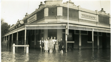 Charlton Golden Grains Museum Inc
Photograph - Telegraph Hotel in 1939 flood, 1939
Telegraph Hotel in 1939 flood. The river level reached 8.25 metres in April.Black & white photograph of Halligan's Telegraph Hotel in 1939 flood. Corner of Armstrong & Camp Streets. Halligans & staff including Tess Maher (Loughnan) standing in front of hotelAvoca Rover flood Easter 1939. Donated by Mrs T Loughnan.flood, hotels, halligan, telegraph hotel, business, armstrong street, charlton -
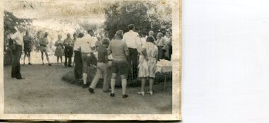 Kiewa Valley Historical Society
Photographs x 2 - Afternoon tea visit to Towong Hill
Towong Hill Homestead is a 110-year-old Federation style mansion situated on a rock outcrop, with views of about 260 degrees. It was built over 2 years by grazier Walter Mitchell from bricks made from local clay dug from the river bank, to be the family home for his new bride Winifred. They established their home in 1904. After the death of Walter in 1917, Winifred relocated her family, but the homestead remained in the families hands. In 1935, Thomas Mitchell (1906-1984) returned home to Australia, a successful Lawyer, and married city girl, Elyne Chauvel, and settled himself back at his childhood home, Towong Hill. Thomas was a world champion slalom skier, had been a prisoner of the Japanese at Changi, and was elected for the Country Party in 1946 and served as attorney-general in the McDonald government. His wife Elayne (1913-2002) is best remembered for her Silver Brumby series of novels for children. But Elyne also wrote a substantial number of non-fiction works about the Snowy Mountains. Photographs demonstrate local Kiewa Valley residents enjoying a community visit to the historic homestead at Towong Hill which holds significance to the early history of the area. Also demonstrates a pictorial history of social activities undertaken during this period2 black and white photographs mounted on buff card. Kiewa Valley residents attending afternoon tea at Towong HillHandwritten in black pen underneath photo - T.W.Mitchell Towong Hill. Afternoon Teat w mitchell, towong hill, kiewa valley -
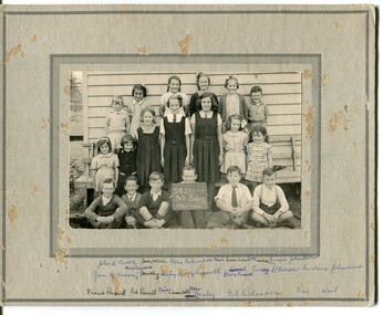 Orbost & District Historical Society
black and white photograph, 1941
This is a photograph of students at Bete Bolong School in 1941. Back Row - John McKeown; Dawn McCole; Anne Richardson; Mavis Coverdale; Joan Richardson; Leslie (Ginger) Johnstone Middle Row - Jan McKeown; Mary Coverdale; Dorothy Healey; Mary Russell; Elvie Purcell; Leslie McKeown; Barbara Johnstone Front Row - Frank Rodwell; Pat Purcell; ? Coverdale; Clem Healey; Gil Richardson; Ray Wait In 1912 the school at Pumpkin Point opened to serve the children of farmers living in the Bete Bolong district. This meant a big change in their way of life because in the past the children had been rowed across the Snowy River each day to attend school at Jarrahmond. Myrtle Bunting was the first HT of the school which had been erected on a block of land purchased from H. Richardson. The school functioned until 1952 when a shortage of pupils caused its closure. As a bus service to Orbost now operated, the school at Pumpkin Point faced permanent closure. J. McKeown bought the building. --------------------------------------------------------------------------------------------------------------------------------------------------------- This is a pictorial record associated with education in the Orbost district,A black and photograph on a light grey card. It has three rows of school children in front of a wooden building. Some are in uniform. attacched is a list of children in the photograph.at bottom - handwritten list of names -
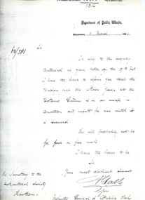 University of Melbourne, Burnley Campus Archives
Letter, Department of Public Works, 11/3/1864
Letter re unsafe state of bridge over Yarra River This is a photocopy of the original letter which was written by A. Gable (?) on behalf of the Inspector General of Public Works. It comments on the unsafe state of the bridge over the Yarra River by the Botanic Gardens. Provided by Diane Nicholas Librarian at Hawthorn Library 1994Letter from Department of Public Works to Secretary of Horticultural Societybridge, yarra river, unsafe bridge, bridge safety melbourne, bridge safety 1800s, a. gable, inspector general of public works -
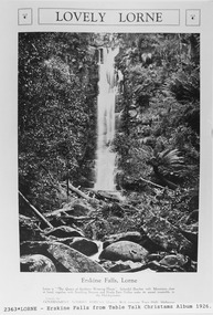 Lorne Historical Society
Pamphlet - Tourist Brochure, Lovely Lorne
The Victorian Railways promoted tourist destinations around Victoria. A folded paper tourist brochure about Lorne The front cover is a coloured painting of Lorne from above the Erskine River towards the main beach. , on the back is a black and white sketch tourist map of the roads, tracks and beauty spots. Inside the first fold are 6 black and white photographs, Cumberland River, Mt St George, Phantom Falls, Cumberland Cliffs, Teddy’s Lookout, leafy walk towards the pier. Inside contains written descriptions of the highlights of Lorne and six black and white photographs, four general views of Lorne, Lover’s Walk, Erskine Falls . souvenirs, victorian railways, publicity -
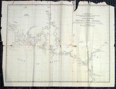 Federation University Historical Collection
Map, British New Guinea, 1893, 1893
The map was surveyed by ship compass, distances by estimation or rate of launch by officers of the Government ; supervised and compiled by J.B. Cameron, G.S. March 1893. This map was in the possession of Charles Carty Salmon (1860-1917), politician, born on 27 July 1860 at Amherst, Victoria. (http://adb.anu.edu.au/biography/salmon-charles-carty-8328 ) Although living in Melbourne Charles Carty Salmon kept property at Talbot. The property was leased, then purchased by the donor's family. A copy of "The Goulburn Weir and its Dependent System of Works" and this map (in a government envelope addressed to Salmon) were left at the property. See http://nla.gov.au/nla.map-rm1894-1 .1) Sketch map showing the rivers and an outline of the coast from Long. 144?30'E. to Long. 146?30'E. Gulf of Papua British New Guinea Scale [ca. 1:316,800]. .2) Large envelope addressed to The Hon Charles Carty Salmon M.P., Talbot, Victoria. The map was folded and stored in this envelope. Map extending from Port Bevan to Kaikavau Pt, showing rivers and notes on soil and vegetation. Relief shown by hachures and spot heights. Also available in an electronic version via the Internet at: http://nla.gov.au/nla.map-rm1894-1 .1) "Enclosure in Despatch No. 32 of 3rd May 1893 - Appendix G.". "Map no. 4 British New Guinea report 1892-93". .2) "This envelope can only be lawfully used by Government Officials on public business. Any use by Officials on private business, or by others under any circumstances, is punishable." "Commonwealth Celebrations. General Secretary's Office, Melbourne."carty salmon, charles carty salmon, new guinea, j.b. cameron -
 Kew Historical Society Inc
Photograph - Zig-Zag Bridge, 1924
Henry Beater Christian (1886-1962) , was a descendant of one of the earliest settler families in Kew. Employed at the Kew Asylum as a 'public servant', he was a skilled amateur photographer, photographing numerous scenes in Kew and on his travels around Victoria. The majority of his photographs date from 1916 to 1929. His finest photographs are housed in two photograph albums. Digital copy of a photograph from page 8 of the 47-page photograph album containing 261 gelatinous silver images, loaned by Diane Washfold with permission given to digitise and hold a copy in our collection. The Zig-Zag Bridge linked the grounds of the Yarra Bend and Kew Asylums. The wooden bridge was constructed in the 1870s and lasted through numerous floods until its destruction in 1929. A horizontal structure, the walkway was reached via a wooden staircase. The steps were requires due to the different levels of the banks on this stretch of the river. The photo is taken from the Kew side of the river. "Zig-Zag Bridge"henry beater christian (1886-1962), landscape photography, kew (vic.) — yarra river, christian-washfold collection, photograph albums, zig-zag bridge -
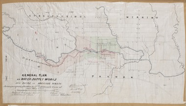 Bacchus Marsh & District Historical Society
Map, General Plan for Water Supply Works, Shire of Bacchus Marsh 1887
Debate about water supply and its planning and development took place in the Bacchus Marsh region from the 1850s through into the twentieth century. This plan was part of documentation to support an application for an additional loan of money from the Ministry of Water Supply to the Bacchus Marsh Shire Water Supply Trust. The plan includes the route of a proposed water channel in the Parwan area, and other features of water supply infrastructure such as the location of standpipes and gates are also shown on the plan.A single page paper map showing a general plan for the supply of water in the Bacchus Marsh area.The plan shows the route of the 'Main Channel' near the Werribee River and a proposed route for a Parwan Channel. The location of 'Dryden's House' near the Werribee River is also shown and the locations of land held by T. (Tom) Oliver and the Racecourse Reserve in Maddingley. Scale 40 chains to 1 inch. The plan is signed by Bacchus Marsh Shire Engineer, W.E. Standfield. The map is pasted into a bound volume containing 76 maps or plans in total. High resolution digital image stored on BMDHS computer network. General Plan of Water Supply Works in the Shire of Bacchus Marsh. Accompanying application for 2nd additional Loan. Original Waterworks district. Additional area. W.E. Standfield, 30/8/87.water supply, water supply maps, water supply bacchus marsh, irrigation, bacchus marsh victoria maps -
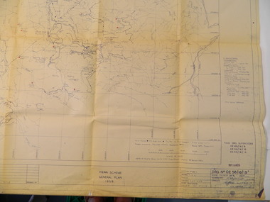 Kiewa Valley Historical Society
Plan - Kiewa Scheme General Plan 1958, S.E.C.V. Design & Construction Dept. Civil Branch, Dec. 1958
The Kiewa Hydro Electric Scheme was constructed by the State Electricity Commission of Victoria. Draftsmen drew up the plan of the layout as per the instructions from the engineers. The plan was drawn up on a transparency sheet and paper prints run off on a 'dyeline' copier. The 'Chief draftsman' and 'Design engineer' and 'Civil engineers recommended it and approved it. Historic: This plan gives a time line for the work on the Kiewa Hydro Electric Scheme. It is a good example of the work of a draftsman and the copying process in 1958.Large topography map of the area covered by the Kiewa Hydro Electric Scheme in 1958. Mountain peaks are marked in red and named. Rivers, roads, construction infrastructure as well as the main areas / names of construction are named. Signed and dated by employees of the S.E.C.V. working on the scheme.state electricity commission of victoria., kiewa hydro electric scheme, plan, engineer, draftsman