Showing 6702 items
matching river
-
 Surrey Hills Historical Society Collection
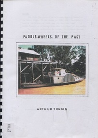
Book, Paddle wheels of the past
The discovery of inland waterways during the early settlement of Victoria and South Australia led to trade being plied up and down the rivers.An A4 80 page comb bound book.paddlewheels, paddlesteamers - murray river (nsw- sa), boats, punts, barges -
 Vision Australia
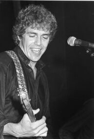
Photograph - Image, Beeb Birtles
Portrait photograph of Beeb Birtles most likely supplied for Carols by Candlelight program when the Little River Band appeared in 1982.B/W photograph of Beeb Birtles.beeb birtles, carols by candlelight -
 Greensborough Historical Society
Photograph - Photograph - Digital Image, Marilyn Smith, Greensborough tennis courts 2021, 15/12/2021
Digital image of tree at Greensborough Tennis Courts 15/12/2021, This image shows the trimmed tree near the Plenty River.Part of a collection of miscellaneous historical images with a connection to the local area.Digital colour photograph. greensborough tennis courts, plenty river -
Lakes Entrance Historical Society
Photograph - MV Blackbird, H D Bulmer, 1940 c
Also a black and white photograph of Peels launch Blackbird in the Tambo River East Gippsland 05098.1 10 x 15 cmBlack and white photograph of postcard of Peels tourist launch Blackbird in Cunninghame Arm opposite Kia Ora House Lakes Entrance VictoriaThe Esplanade at Lakes Entrance from the West Endtourism, boats and boating -
 Greensborough Historical Society
Map, Melbourne and Metropolitan Board of Works. Survey Division, MMBW, Yarra 2500 / 12.24. Plenty and Blue Lake, 1977_10
Melbourne and Metropolitan Board of Works. Yarra 2500 [base map]. 12-24, Municipalities of Whittlesea 239 and Diamond Valley 257. Shows street names, easement sizes, lot numbers, lodged plan numbers, names of prominent features, contour values, creek or river names. Watsonia Railway Station and environs. Prominent streets: Memorial Drive. Includes Plenty River and Blue Lake in the Plenty Gorge.MMBW Map in 1:2500 [scale] series. Cream parchment with green tape reinforcing on edges and punched holes on left edge.mmbw, melbourne and metropolitan board of works, shire of diamond valley, plenty - maps, blue lake -
 Halls Gap & Grampians Historical Society
Newspaper - B/W, 26/01/2001
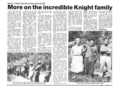
This is a newspaper article written by Ida Stanton for the Stawell Times-News "Halls Gap Extra" and published on Friday, 26 January 2001, p.18. It refers to Gus Knight and his family when they lived at Henham and on the Wannon River. The photos included in the article show: 1) a bogged vehicle being pulled out of the Wannon River by a large group of people; and 2) Gus, Ellen and Charles Knight in 1939.A newspaper article headed "More on the incredible Knight Family", containing two photos.people, knight -
![Map, Plan showing proposed deviation of the road through McKenzie's Flat to Bacchus Marsh. [Undated]](/media/collectors/5e461d8021ea67224c82f2a1/items/677d22f37f2053f3e5d500dc/item-media/677d25247f2053f3e5d50950/item-fit-380x285.jpg) Bacchus Marsh & District Historical Society
Bacchus Marsh & District Historical SocietyMap, Plan showing proposed deviation of the road through McKenzie's Flat to Bacchus Marsh. [Undated]
The date of this map or plan is uncertain. McKenzie's Flat is a bushland picnic area on the Lerderderg River in the Lerderderg State Park close to Bacchus Marsh. The proposed road deviation shown on this map is very close to a sharp bend in the Lerderderg River which shows an island in the centre of that bend. The name of a landholder, J.B. Perry is shown on the map close to the area of the road deviation.The land shown is identified as within the Parish of Merrimu.Single page map showing a proposed deviation of the road from McKenzie's Flat to Bacchus Marsh. Scale: 5 chains to 1 inch. Part of a set of maps which are pasted into a bound volume containing 76 maps or plans in total. High resolution digital image stored on BMDHS computer network. mckenzies flat bacchus marsh, bacchus marsh roads and streets -
 Otway Districts Historical Society
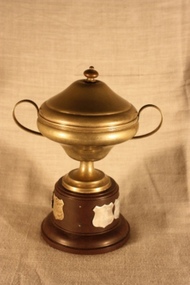
Memorabilia - Trophy, Plate Craft, Otway Tennis Association, B grade Junior Premiers, c.1962
Trophy. Otway Tennis Association, B Grade Junior Premiers. An EPAINS lidded-cup with handles on a round bakelite base, with the names of winning teams from 1963/64, 1975/76, and 1982/83 to 1987/88 inclusive.1963/64 Beech Forest B 1975/76 Lavers Hill 1982/83 Johanna 1983/84 Carlisle River 1984/85 Lavers Hill 1985/86 Lavers Hill 1986/87 Wyelangtatennis, otway tennis association, lavers hill, beech forest, johanna, carlisle river, wyelangta -
 Orbost & District Historical Society
black and white photograph, 1971
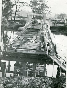
This photograph shows the second major bridge across the Snowy River at Orbost. The current Snowy River bridge is the fourth to provide a crossing to the township of Orbost. The first, in 1891, lasted just two years before it succumbed to flood waters. The bridge in this photograph was built in the 1920s as a road and rail bridge, and was again partly washed away by flood waters in 1934. After the end of the first World War the Victorian Railways considered an extension of the railhead across the river at Orbost, and in 1922 a new timber and steel girder structure, a joint Country Roads Board — Victorian Railways venture, was built and completed at a cost of £41,000 (the steel girders came from the Flinders Street viaduct reconstruction). Subsequently it was decided not to take the railway across the river, and the bridge was only used by road traffic. It was severely battered by floods during its life. and after the devastating 1971 floods was eventually replaced by the current bridge in 1975. (info from Newletter 54N by John Phillips)This is a pictorial record of the flood damage in 1971 when part of the Snowy River Bridge was washed away.A black / white photograph of a bridge which has been damaged by floodwaters. It shows one end has been washed away.orbost-snowy-river-bridge-1971 floods-orbost-1971 -
 Eltham District Historical Society Inc
Map (item) - Sales Brochure, Plenty Township Estate and Bryn Teg Hill's Estate, Coghill & Haughton, Melbourne, c.1924
Plenty Township Estate "The rapid growth of Greensborough and the great traffic development on the main road between Heidelberg and Eltham augurs well for Plenty Township Estate. Already a Store, Post Office and State School have been started, and the activities of the Local Progress Association will help the district forward considerably. Within walking distance of the Montmorency and Greensborough stations." Bryn Teg Hill's Estate "Better known as "The Old Sand Hill, "within walking distance of the Montmorency and Greensborough railways stations." "Some few years back Mrs Thomas subdivided portion of the Sand Hill Paddocks, and the areas sold have been settled and many converted into charming outer suburban garden homes with cultivation and orchard plots. The south-eastern slope gives the land a grand outlook over the Yarra Valley on to the Dandenoings, and the are is very picturesque and homely." "A number of the blocks contain large deposits of valuable building sand, which should prove good speculation in view of the forecast for further rapid home development along the Eltham Suburban Electric Service." Sand Hills Road (Old Eltham Road) Date estimated as c.1924 - Electricification of railway line to Eltham referenced on map occured April 1923 and Mrs Mary Thomas died August 1925. Her home Bryn Teg became part of the Heidelberg Golf Club in 1927.The establishment of Lower Plenty as a suburban growth area supported by easy commuting facilitated by the elctrification of the Eltham railway linebonds road, bridge, bryn teg hill's estate, coghill & haughton, eltham road, heidelberg golf club hotel, houses, lower plenty, lower plenty bridge, lower plenty road, main road, plenty hotel, plenty river, plenty township estate, real estate agent, sales brochure, sand hills road, the old sand hill, sand hill paddocks, woodfull road, old eltham road, bryn teg, mrs m thomas -
 Bendigo Historical Society Inc.
Document - PEARCE COLLECTION: ACCOUNTS TO ELDRIDGE & BURNET.(VARIOUS PRINTED)
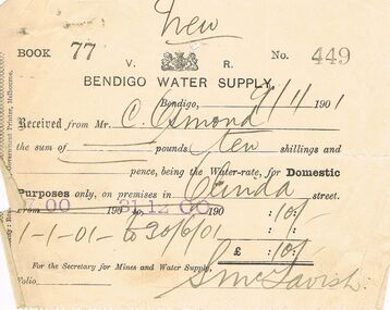
Pearce Collection: Accounts to Eldridge & Burnet.(various printed); 1. State Rivers and Water Supply Commission ,1912 to premises at Specimen Hill (x2); 2. Victorian Railways Commissioners, Kangaroo (Flat?) 1912 - to 'J Stevenson'; 3. Bendigo Water Supply1901 - to C Osmond, premises Olinda St.business, retail, plumber, state rivers and water supply commission. victorian railway commissioners kangaroo flat. bendigo water supply. c. osmond. olinda street. -
 Bendigo Historical Society Inc.
Postcard - WES HARRY COLLECTION: 7 POSTCARDS, 1904 - 05
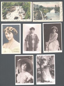
Seven postcards, all but two are depicting theatre actresses : (a) Miss Gabrielle Ray , (b) Miss Madge Lessing , (c) Miss Gabrielle ray , (d) Miss Julia Marlowe , (e) Nina Sevening , (f) Myers Falls Healesville , (g) Gold sluicing on the Ovens River near Germantown.postcard, various themes, gabrielle ray, madge lessing, julia marlowe, nina sevening, myers falls healesville, gold sluicing, ovens river, germantown -
Bendigo Historical Society Inc.
Map - AXEDALE, COUNTIES OF BENDIGO & RODNEY, 1961
Map, Axedale, Counties of Bendigo & Rodney.Axe Creek, Campaspe River, Longlea Railway Station, Axedale Railway Station, Wallan & Bendigo Railway.Township of Axedale. By authority A.C.Brooks, Govt. Printer, Melbourne.Drawn and reproduced at the Dept. of Lands and Survey, Melbournd. Price 1/-. 1961. (number 61 in map cupboard 1)A.C.Brooks, Government Printer, Melbourne.map, bendigo, axedale -
Bendigo Historical Society Inc.
Map - GOORNONG : COUNTY OF BENDIGO, September 1943
Map. Goornong, County of Bendigo, Egerton, Bagshot, Ellesmere, Muskerry, Campaspe, Nolan, Campaspe River, Town of Goornong. By authority : H.E. Daw, Government Printer, Melbourne. Drawn and reproduced at the Department of Lands and Survey, Melbourne, Victoria. September 1943, Price 2/-. (number 44 in map cupboard 1)H.E. Daw, Government Printer, Melbourne.map, bendigo, goornong -
 Yarra City Council
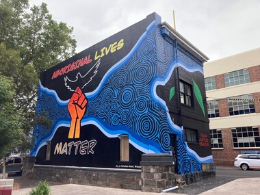
Artwork, other - Mural, Ky-ya Nicholson-Ward, Aboriginal Lives Matter, 2021
"The fist references the Black Lives Matter movement and also represents the strength of Indigenous peoples all over the world and symbolises solidarity and justice for everyone affected by systematic racism. Bunjil (wedge-tailed eagle) is flying high on the building. He is the creator spirit for Wurundjeri people who looks over us and protects us. Bunjil represents healing and power to our people. The blue circles and lines represent revival and waterways; in particular, they depict the Birrarung (Yarra River), which is very significant for the Wurundjeri people. Our people are known as the Manna Gum people. The leaves in the artwork highlight Wurundjeri people and their Country. These leaves also represent the cleansing of negative spirits. The Manna Gum leaf is also an important symbolic offering in our traditional Welcome to Country ceremony. Leaves are offered to visitors as they are granted safe passage through our land. They are made welcome to everything from the tops of the trees to the roots of the earth. We ask that they take care of the land, plants and animals and to respect the protocols and rules of the Traditional Owners whilst on our Country."In 2020 Council declared its support for the global Black Lives Matter (BLM) movement. In consultation with Yarra City Council's Yana Ngargna advisory group a motion was prepared and passed unanimously by all Councillors. A number of actions were generated from this decision; one of which was for Council to commission a large-scale mural that aligned with the movement. Emerging artist Ky-ya Nicholson-Ward, a proud Wurundjeri, Dja Dja Wurrung, Nguarai Illam-Wurrung, German and Irish woman, created the mural installed on a building in Peel Street Park, Collingwood. Selected by Council's Yana Ngargna, Black Lives Matter Working Group the artwork identifies the cultural importance of the local area to the Wurundjeri Woi Wurrung people as the Traditional Owners. With a strong focus on Aboriginal identity the mural outlines the local context of the Black Lives Matter movement, which is connected to racism, policing of Aboriginal and Torres Strait Islander peoples and associated deaths in custody. The artwork acknowledges the ongoing challenges faced by Aboriginal community members and their struggle to survive white systems, policies and institutions. Ky-ya's mural tells the story of Aboriginal resilience, strength and self-determination; and will support the process of healing. It is a celebration of the local Aboriginal and Torres Strait Islander community; the significant Aboriginal history of Fitzroy, Collingwood and surrounds; and community's continuing cultural connection to the area. Importantly, this artwork provides a platform to educate a broader audience about the local context of the Black Lives Matter movement and Aboriginal deaths in custody. The mural will activate this site, enliven the area, promote inclusion, incite conversation and contribute to the creative capital of this locale. A welcoming environment for Aboriginal and non-Aboriginal communities.Aboriginal Lives Matter Ky-ya Nicholson WardOn a black background a hand fist (strength, solidarity and justice) is placed at the centre of the building; Bunjil (wedge-tailed eagle) is depicted flying high on the building; blue circles and lines represent revival and waterways (Birrarung-Yarra River) and the leaves in the artwork highlight Wurundjeri people (cleansing of spirit and welcome to Country)The artist name 'Ky-ya Nicholson Ward' painted in white, low right of the wall facing into Peel Street Park. black lives matter (blm) movement, wurundjeri woi wurrung, bunjil, identity, birrarung, country -
 Tramways/East Melbourne RSL Sub Branch - RSL Victoria Listing id: 27511
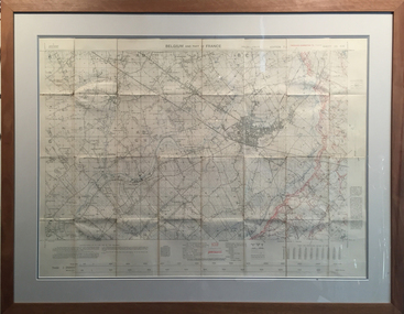
Map and Legend, Trench Map - France Sheet 36 N.W
This is an actual battle map used by Australian Forces in the battle of the Somme in France in April 1917. It is an ordinance survey map of the trenches in the area. It is framed in two pieces, one being the main map and the other the legend used to read the map. It details the river 'La Lys Riviera' and the city 'Armentieres', in the Somme. somme, trench map, ww1, belgium, france, armentieres, 1917, ordinance survey map -
 Bendigo Historical Society Inc.
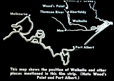
Slide - DIGGERS & MINING. DIGGERS AND MINERS, c1850s
Diggers & Mining. Diggers and miners. Walhalla - Gold Town. This map shows the position of Walhalla and other places mentioned in this film strip. (Note Wood's Point and Port Albert.) Other places on map; Melbourne, Moe, Thomson River, Aberfeldy. Markings: 5 995 WAL. Used as a teaching aid.hanimounteducation, tertiary, goldfields -
 Kew Historical Society Inc
Plan - Subdivision Plan, Riversdale Estate, 1939
The Kew Historical Society collection includes almost 100 subdivision plans pertaining to suburbs of the City of Melbourne. Most of these are of Kew, Kew East or Studley Park, although a smaller number are plans of Camberwell, Deepdene, Balwyn and Hawthorn. It is believed that the majority of the plans were gifted to the Society by persons connected with the real estate firm - J. R. Mathers and McMillan, 136 Cotham Road, Kew. The Plans in the collection are rarely in pristine form, being working plans on which the agent would write notes and record lots sold and the prices of these. The subdivision plans are historically significant examples of the growth of urban Melbourne from the beginning of the 20th Century up until the 1980s. A number of the plans are double-sided and often include a photograph on the reverse. A number of the latter are by noted photographers such as J.E. Barnes.The Riversdale Estate in Hawthorn created a subdivision of 20 allotments bordering on Riversdale Road and Riversdale Court (which was created by the subdivision). The Locality Plan at right lists the major public buildings in the area: Burnely Horticultural Gardens, Hawthorn Tram Depot and Railway Station, Scotch College and the River Yarra and The Boulevard.subdivision plans - hawthorn, riversdale estate -
 Kew Historical Society Inc
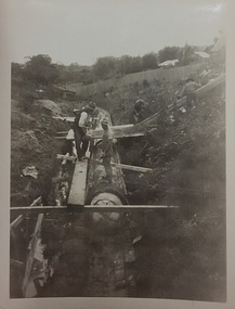
Photograph, City of Kew, City of Kew, Cecil Street Drain, 1936
An original photograph donated to the Kew Historical Society by the City's Engineering Department following the amalgamation of Kew into the City of Boroondara. While not all of the photographs are of Studley Park, Kew or East Kew, each photo provides a fine snapshot of the work of local government engineering departments of the period. They reveal they types of labour conducted, the techniques used and the equipment and machinery in the possession of the local government authority. Historic and rare photograph of major public works in Kew in the 1930s.Public works. Men at work in the creek bed of Connor's Creek in Kew, while constructing the underground drain. Connor's Creek was one of the two main tributaries of the Yarra River in Kew. It originated somewhere near the grounds of Genazzano FCJ College. The barrel drain was finally completed in 1941 at a cost of £14,000. Inscription on reverse: "City of Kew / Cecil st drain / November 1936". city of kew, city of kew (engineering department), engineering, connor's creek (kew) -
 Mont De Lancey
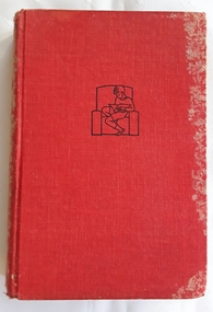
Book, A.M. Irvine, The Two J.G's - A Story for Boys, early 1900's
A story about two teenager boys who swap identities to fool a long term older man who has kindly offered to take them in to his care to tutor them due to the boys' family and behaviour problems.A red cloth hardcover book The Two J.G's - A story for Boys by A.M. Irvine with a black outline of a boy reading at the top of the front cover. The spine has the title, author and publisher in black lettering. The frontispiece has a black and white illustration of a man and boy rescuing a boy from a river. 96p.fictionA story about two teenager boys who swap identities to fool a long term older man who has kindly offered to take them in to his care to tutor them due to the boys' family and behaviour problems. fiction boys, family life, friendship stories -
 Kiewa Valley Historical Society
Folder - Family History, The Maddison Family, 1968 and later
George Maddison selected land in 1877 between the East and West Kiewa branches of the Kiewa River - known as the "Island". Now Mt Beauty.Pioneer family in the Kiewa ValleyPlastic brown folder with transparent front held by 2 gold metal slide clips. 9 clear plastic sheets holding 4 typed sheets, 3 typed sheets by Ted Maddison 1968, 4 handwritten pages in 1 plastic sleeve and 6 handwritten pages in 1 plastic sleeve (the handwritten sheets are the same as the typed sheets.)maddison family; mount beauty; kiewa valley -
 Eltham District Historical Society Inc
Photograph, Fay Bridge, Longridge, Alexander Road, Warrandyte, 4 May 2019
Situated on the Warrandyte side of the Yarra River opposite Glynn's Dairy Farm, North Warrandyte, the property is in ruins and remains fenced off as of 2023fay bridge collection, glynns, longridge, ruins, warrandyte, 2019-05-04, alexander road -
 Greensborough Historical Society
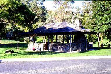
Slide - Photograph, John Ramsdale, Picnic shelter, Pioneer Reserve: Slide 22, 1990s
Photograph shows Pioneer Reserve picnic shelter in Greensborough. This shelter was built from bluestones from the old bridge over Plenty River.Part of the John Ramsdale collection of slides and audio visual material.Colour photograph scanned from slide.No maker's marks. No caption on slide.plenty river, bluestone bridge greensborough, pioneer reserve greensborough -
 Greensborough Historical Society
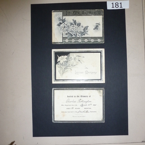
Bereavement Cards, Charles Partington, died March 13th 1905, 13/03/1905
Charles Partington came to Greensborough with his family in the 1857 to farm along the Plenty River. Members of his family still live in the area.A memory of a Greensborough pioneer, these cards are an example of bereavement cards in the early 20th century3 x black and white bereavement cards (possibly accompanied floral tributes). "Sacred to the memory of Charles Partington who departed this life March 13th 1905. Aged 80 years and was later interred in the Strathallan Cemetery"charles partington, ellen whatmough, partington family, bereavement cards -
 Greensborough Historical Society
Map, Municipality of Heidelberg Plan No. 481, 23/9/1949
Central area of Greensborough, South boundary Grimshaw Street, showing river and buildings in green and gradients in red. Adjoins Map No. 480 to West.Black & white map with features in red and green. Scale: 160 feet to 1 inch.greensborough, grimshaw street greensborough -
 Greensborough Historical Society
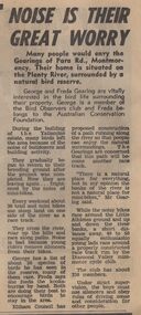
Newspaper Clipping - Digital Image, Noise is their great worry, 21/08/1973
A family living near the Plenty River in Montmorency are concerned about the noise of mini-bike riders and their effect on local bird life. [1973]Digital copy of newspaper article, black text.plenty river montmorency, montmorency -
 Greensborough Historical Society
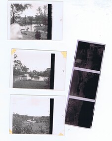
Photographs and Letter, Greensborough 1960s, 1960s
Taken during a flood in the late 1960s, showing parts of both old and new bridge across the Plenty River, kiosk and Fitton house.Three photographs, with negatives and covering letter from Tony Fitton, with handwritten descriptive lettergreensborough, plenty river greensborough, fitton family -
 Greensborough Historical Society
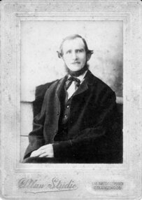
Photograph - Digital image, Charles Partington, 1880s
Charles Partington and family came to Melbourne in the 1857 and moved to Greensborough where they farmed along the Plenty River. Descendants still live in Greensborough.A pioneer Greensborough family.Digital copy of black and white studio photograph.charles partington, partington family -
Greensborough Historical Society
Compact disc, Heritage Victoria Application, 2007_
Application for grant from Heritage Victoria including supporting material. Dated 2007. The application deals with the proposed Plenty River Heritage Trail.An example of a grant application.1 compact disk with text files."Heritage Victoria Application"heritage victoria, grant application, noel withers, plenty river, plenty river heritage trail -
 Greensborough Historical Society
Newspaper clipping, Fiona Cameron, Pioneer bridge is demolished, by Fiona Cameron, 1974_
Describes the removal of the bluestone bridge abutment on the north side of the Plenty River in Greensborough, to make way for the Diamond Creek Road bridge duplication.Photocopy of news articleplenty river, diamond creek road