Showing 7071 items
matching snowy-river
-
 Kew Historical Society Inc
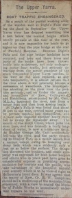
Newspaper - Article, The Upper Yarra: boat traffic endangered, 1918-20
An item of ephemera relating to tourism and recreation on the Yarra River in Melbourne in the first half of the twentieth century.An item from a large collection assembled by the Christian and Washfold families of Kew, including photographs, postcards, and ephemera. Many of the items in the Christian-Washfold Collection relate to the Yarra River and its use as as a recreational resource. Numerous items in the collection are historically important in that they are rare and often unique records of vanished locations or past recreational activities.Article describing the effects of the partial collapse of the weir at Dight’s Falls and its impact on water levels between Kew, Fairfield, and Heidelberg. The article is undated however as it describes Cr Harry Tompkins as Mayor of Kew it must date to the years 1918-20.christian-washfold collection, river yarra -- recreation, dight's falls -
 Lakes Entrance Historical Society
Postcard - Ensay Hotel, 1920c
Ensay Hotel now known as Little River Inn at 64-70 Johnson St EnsayBlack and white postcard of a view of the Ensay Hotelhotels, accommodation -
 Bendigo Historical Society Inc.
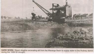
Newspaper - JENNY FOLEY COLLECTION: HARD WORK
Construction of the Waranga Basin initially took place 1905-1915 when it was dug by pick, shovel and horse-drawn scoops. It's embankment was initially 29ft high but over time this was increased to 40 ft. It is an off-river dam that is fed by diversion of water from the Goulbourn River and its aim is to provided irrigation water.Bendigo Advertiser ''The way we were'' from 2003. Hard work: steam dragline excavating silt from the Waranga Basin to supply water to the Rodney district during the 1938-39 drought. The clip is in a folder.newspaper, bendigo advertiser, the way we were -
 Kiewa Valley Historical Society
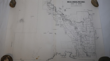
Map - Mullindolingong
Land owners of land in the Kiewa Valley in 1928The Kiewa Valley was farming country with families settling in the area prior to 1928 Two sheets the same: (one old with paper joined together and the other is a copy without any joins. 21 6 1928 dated Map of Mullindolingong / County of Bogong showing land owners along the Kiewa River and beyond.Produced by the Department of Lands and Survey, Melbournemullindolingong, kiewa valley, land owners, families of the kiewa valley -
 Federation University Historical Collection
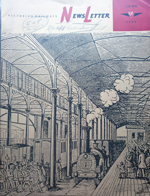
Magazine - Newsletter, Victorian Railways Newsletter, June 1967, 06/1957
Soft covered magazine of 16 pages. It includes an article of the Geelong Line centenary, and a photo of the original Geelong line laid with Barlow, or saddle-back rail; cement, Little River Station, , Renewing crossings, , memorial to railways returned servicement at the Ballarat NOrth Workkshops. victorian railwat, geelong railway centenary, cement, cp vans, railcrossings, trains -
 Glenelg Shire Council Cultural Collection
Souvenir - Souvenir Wine Glass, c. 1985
Wine glass, souvenir of Heywood's 150th 1835 - 1985. Gold rim on top, gold depiction of bullock dray, with 'Heywood 150th' above and '1835 - 1985' below, in gold. Opposite side of glass has history of the Heywood Fitzroy River bridge in gold print.souvenir, heywood, 150th anniversary, 1835 to 1985 -
Glenelg Shire Council Cultural Collection
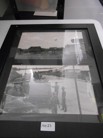
Photograph - Sheet of 2 contact prints - Various pastoral scenes, 1960-1970
Sheet of 2 contact prints from glass plate negatives. Top: Weatherboard house, verandah with iron lacework from roof, verandah roof striped. Several ladies and small children on verandah. Bottom: Five women standing on wooden jetty on river bank. -
 Warrnambool and District Historical Society Inc.
Cards, Post Cards Warrnambool, Early 20th century
These cards have been sent to Christina Lawrance (1889-1970). She was born in Williamstown, Victoria and married James Robertson in 1912. They lived in the Gundagai area of N.S.W. on a property named ‘Nargoon’ (sheep and cattle) and they had five children. One of the daughters, Margaret, married Jeffrey (Bill) Whitehead of ‘Goodwood’ near Hawkesdale and the cards have been passed on to us from a Whitehead descendant. It is not known who sent the cards to Christina Lawrance who would have been 16 or 17 at the time. These cards are of interest because they are of Warrnambool scenes and demonstrate the practice at the time (1906) of sending cards that had photographs of local scenes. The photographs, although printed in great numbers, are of historical interest today. The cards are also of interest because of the recipient’s connection with the Warrnambool area – Christina Lawrance is an important person in the family tree of the Whitehead families today. These are four colour post cards in green, yellow and black tonings. They have photographs of the Hopkins River, Warrnambool and the Hopkins Falls on one side. They all have a penny red Victorian stamp and were posted from Warrnambool in 1906. The address is handwritten in black ink. Addressed to: ‘Miss C. Lawrance, C/O Kirkpatricks Hotel, Mornington, Victoria’whitehead family of ‘goodwood’, christina robertson nee lawrance, history of warrnambool and district -
Bendigo Historical Society Inc.
Map - LYELL : COUNTY OF BENDIGO, 24-10-84
Map. Lyell, County of Bendigo, Eppalock, Sedgwick, Sutton Grange, Hawkestone, Kimbolton, Coliban River, Myrtle Creek. State School. Photo-Lithographed at the Department of Lands and Survey, Melbourne by J. Noune, 24-10-84. (number 71 in map cupboard 1)J. Nounemap, bendigo, lyell -
Bendigo Historical Society Inc.
Map - LYELL : COUNTY OF BENDIGO, 24-9-07
Map. Lyell, County of Bendigo, Sedgwick, Sutton Grange, Hawkestone, Kimbolton, Eppalock, Myrtle Creek, Coliban River. Photo-Lithographed at the Department of Lands and Survey, Melbourne by T.F. McGauran, 24-9-07, Price 1/-. (number 70 in map cupboard 1)T.F. McGauranmap, bendigo, lyell -
Bendigo Historical Society Inc.
Map - DERBY : COUNTY OF BENDIGO, 1-9-09
Map. Derby, County of Bendigo, Inglewood, Loddon River, Tarnagulla, Woodstock, Leichardt, Bridgewater, Bendigo to Inglewood Railway. Photo-Lithographed at the Department of Lands and Survey, Melbourne, by T.E. McGauran 1-9-09. Price 1/-. (number 55 in map cupboard 1)T.E. McGauranmap, bendigo, derby -
Bendigo Historical Society Inc.
Map - NOLAN, COUNTY OF BENDOGO, 7-5-30
Map, Nolan, County of Bendigo, Egerton; Elmore; Goornong. Campaspe River, Elmore Estate, By Authority: H.J.Green, Government Printer,Melbourne.Price 2/-.Drawn and Reproduced at the Dept. of Lands and Survey,Melbourne,Victoria.7-5-30. (number 1 in map cupboard 1)H.J.Green,Government Printermap, bendigo, nolan -
Port Melbourne Historical & Preservation Society
Photograph - Double-sided aerial photograph, Hobson's Bay and the Yarra River/Port Phillip and Western Port Bay, Surveyor General and Director of Mapping, Apr 1990
Landsat imagery - an extract from the atlas of VictoriaAerial photos of Port Phillip and Western Port (double sided aerial photographs), framed and with timber display stand. 1995 side A: Hobson's Bay and Yarra River - aerial photo mosaic; side B. Port Phillip and Western Port Bays - satellite photomelbourne harbor trust - port of melbourne authority -
Port Melbourne Historical & Preservation Society
Flyer - Westgate Park, Melbourne and Metropolitan Board of Works, 1990s
Folded coloured flyer with stylised drawing of West Gate Bridge and a heron in black. Green stripe to represent the park and blue for the river. Group of buildings on left representing the city. The colour scheme continues in the folded pages . Maps of park and area, plus artists representation.parks and gardens, west gate bridge, westgate park, mmbw, melbourne and metropolitan board of works -
Port Melbourne Historical & Preservation Society
Photograph - Aerial view of the mouth of the Yarra from Williamstown, 2006
B&W aerial photographic view of the mouth of the Yarra River, taken from above Williamstown and looking east. Greenwich Bay and the cooling water outlet for Newport Power Station in the foreground, the entrance and Webb Dock in the centre, Sandridge Beach and the city upper right.piers and wharves - webb dock, yarra river, garden city, fishermans bend, newport power station -
Bendigo Historical Society Inc.
Tool - INDIGENOUS STONE TOOL COLLECTION: STONE AXE HEAD, LODDON AREA
Dark brown stone axe head, semi circular in shape. Number 12 stuck on stone. Interpretive sign reads' Stone Age Implements, exhibits 11 - 15. All found on the banks of the Loddon River near Bridgewater, Victoria. Stone Axe Heads'first people, indigenous, loddon river, bridgewater -
 National Vietnam Veterans Museum (NVVM)
Photograph, APC's
Two times black and white Photograph of APC's and troops. Photo 1 - An unmanned APC sits unmanned near a tent camp. A C130 flys overhead. Photo 2- Two manned APC's on a village road nearby a river. ARVN and Australian troopers nearby.armoured personnel carrier, c-130 hercules, arvn, photograph -
Tatura Irrigation & Wartime Camps Museum
Packing Slip Envelope, pre 1990
Spencer Street Railway Station now known as Southern Cross.Regular size envelope, brown paper. Meant to hold packing slip. Has reinforced hole for tying to parcels. Wording indicates to be used at State Rivers and Water Supply Commission store yards at South Melbourne for Government carrier to Spencer Street Railway Station.To SRWSC Spencer St Railway Station per Government courier to SR & WSC store yard Brady Street South Melbourne. On rear are instructions to carrier.spencer street railway station, srwsc -
 Kew Historical Society Inc
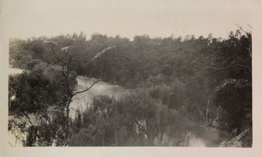
Photograph - Flood, Zig-Zag, Kew, 1924
Henry Beater Christian (1886-1962) , was a descendant of one of the earliest settler families in Kew. Employed at the Kew Asylum as a 'public servant', he was a skilled amateur photographer, photographing numerous scenes in Kew and on his travels around Victoria. The majority of his photographs date from 1916 to 1929. His finest photographs are housed in two photograph albums. Digital copy of a photograph from page 5 of the 47-page photograph album containing 261 gelatinous silver images, loaned by Diane Washfold with permission given to digitise and hold a copy in our collection. This is a photograph of the river at Kew during a flood in January 1924."Flood / Zig-Zag Kew / 1.24"henry beater christian (1886-1962), landscape photography, kew (vic.) — yarra river, christian-washfold collection, photograph albums, floods -- yarra river -- kew (vic.) -
 Kew Historical Society Inc
Photograph - Yarra River, Studley Park, 1924
Henry Beater Christian (1886-1962) , was a descendant of one of the earliest settler families in Kew. Employed at the Kew Asylum as a 'public servant', he was a skilled amateur photographer, photographing numerous scenes in Kew and on his travels around Victoria. The majority of his photographs date from 1916 to 1929. His finest photographs are housed in two photograph albums. Digital copy of a photograph from page 7 of the 47-page photograph album containing 261 gelatinous silver images, loaned by Diane Washfold with permission given to digitise and hold a copy in our collection. This photograph appears to be of the junction of the Yarra River and the Merri Creek."Studley Park / Kew"henry beater christian (1886-1962), landscape photography, kew (vic.) — yarra river, christian-washfold collection, photograph albums, merri creek, yarra river -
 Wodonga & District Historical Society Inc
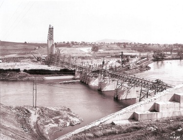
Album - Hume Reservoir Australia Album - General View of Works from New South Wales end, Looking Upstream, August 1927
This set of photos is from a leather bound album bearing the inscription "HUME RESERVOIR AUSTRALIA" plus 'The Rt. Hon. L. C. M. S. Amery, P. C., M .P.' all inscribed in gold. It was presented to The Rt. Hon. L. C. M. S. Amery, P. C., M. P, Secretary of State for Dominion Affairs on the occasion of his visit to the Hume Reservoir on 2nd November 1927. This album is of local and national significance as it documents the planning and development of the Hume Reservoir up to 1927. It was the largest water reservoir in the British Empire. The album records the pioneering engineering work that went into its construction.DEPARTMENT OF PUBLIC WORKS, N.S.W. RIVER MURRAY WATERS SCHEME. HUME RESERVOIR. 23. General view of works from the New South Wales end, looking downstream. The features are generally speaking the same as in the last view 22 (Record WHS 00716) in reverse.hume reservoir australia, river murray waters scheme, hume reservoir construction -
Lakes Entrance Historical Society
Book, Gippsland Heritage Journal No 11, 1991
Issue 11 of a series of Journals showcasing Gippsland history contains articles on Limestone Creek, Crooked River School, Inverloch, Port Albert, Wattle Bark Industry and dairy farming personalities sister Ellen Mc Carthy, Amos Brazier, John Lardner, Tomsettlers, schools, agriculture, industrial -
 Lakes Entrance Historical Society
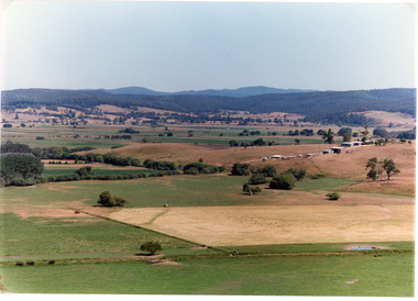
Photograph - Mossiface Flats, Tambo Shire, 1994
Also second identical copyColour photograph of the Mossiface Flats, near Bruthen, shows paddocks of the rich river flats, timbered foothills in the distance, with mountain range behind. Some paddocks have been mown for grass hay. Farm buildings in foreground and background. Dam in foreground. Bruthen Victoriaanimals, agriculture, vegetation, topography -
 National Vietnam Veterans Museum (NVVM)
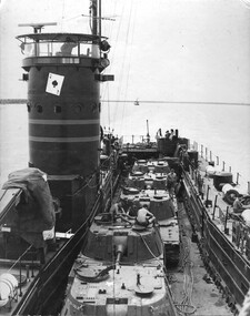
Photograph, Gibbons, Denis, Ace of Spades 1
Denis Gibbons (1937 – 2011) Trained with the Australian Army, before travelling to Vietnam in January 1966, Denis stayed with the 1st Australian Task Force in Nui Dat working as a photographer. For almost five years Gibbons toured with nine Australian infantry battalions, posting compelling war images from within many combat zones before being flown out in late November 1970 after sustaining injuries. The images held within the National Vietnam Veterans Museum make up the Gibbons Collection.A black and white photograph of the Australian Army Landing Craft the Vernon Sturdie or 'The Ace of Spades' as it makes its way up the Mekong River towards Long Binh to deliver American tanks to the Vietnamese Army. The Ace of Spades worked extensively in the Mekong Delta area.photograph, landing craft vernon sturdie, the ace of spades, mekong delta, long binh, gibbons collection catalogue, denis gibbons, photographer, vietnam war, vietnamese army -
 Warrnambool and District Historical Society Inc.
Book, George Rolfe's Book of Abstracts, Circa 1865
Alphabetical entries about many topics from fruit trees to Legislation, to Senate of America George Rolfe came to Warrnambool in 1872 and by 1883 was well established on the banks of the Hopkins River at Lyndoch. In 1884 he purchased Shipley which also had frontage to the Hopkins River. He participated in the social and sporting life of Warrnambool and was a keen rower.An interesting collection of thoughts and life of one of the early merchants and farmers of the area. He was a generous benefactor of the hospital.Dark green hard cover with maroon spine and corners. Pages are lined and alphabetical. Hand written entries throughout. : Inside front cover is label ”Cook & Fox, Account Book Manufacturers, Stationers, Bookbinders machine Rulers, Importers 58 Queen St Melbourne. Handwritten on front page “G Rolfe Senr. Book for extracts 1865. warrnambool, george rolfe, lyndoch, book for extracts -
 Greensborough Historical Society
Photograph - Digital image, Frank Robinson, Greensborough from Pope's paddock, 1956_
Greensborough from Pope's paddock. Pope's paddock was across the Plenty River from Blackjack. The Blackjack property, house and acres of fruit orchards ran down to the Plenty River off Hume Street Greensborough and was the home of the Robinson family to late 1956. The photographs were taken as slides by Frank Robinson and digitised by his son James in 2015.Digital copy of colour photograph.blackjack, robinson family, popes paddock -
 Eltham District Historical Society Inc
Photograph, Old Lower Plenty Bridge, c.1970
Old bridge across the Plenty River at Lower Plenty now part of the Plenty River Trail. Part of a slide show presentation "Bridges & Waterways of the Shire" by Russell Yeoman to the 13 September 1989 Society meeting. The presentation included slides of historic photos from the Shire of Eltham Pioneers collections as well as several recent views.Black and white photographmain road, plenty river, bridge, lower plenty, plenty river trail -
 Eltham District Historical Society Inc
Negative - Photograph, Russell Yeoman, Old Lower Plenty Bridge, c.1970
Old bridge across the Plenty River at Lower Plenty now part of the Plenty River Trail. Part of a slide show presentation "Bridges & Waterways of the Shire" by Russell Yeoman to the 13 September 1989 Society meeting. The presentation included slides of historic photos from the Shire of Eltham Pioneers collections as well as several recent views.Roll of 35mm black and white negative film, 4 of 7 stripsIlford HP4bridge, lower plenty, main road, plenty river, plenty river trail -
 Eltham District Historical Society Inc
Photograph, The Leader, The "Black Swan" Mine and "The Old Dam", Warrandyte Gold Fields, 1897
Reproduced from "The Leader" 14th Aug. 1897, page 7 The "Black Swan" mine - on Captain Selby's property of 200 acres. Discovered by Captain Selby 8 years ago. He is working it himself. 'The shaft is down 70 feet and with deeper sinking the reef is found to increase in width. Nearly £2,000 has been obtained from this mine, the gold being of high quality, fetching £4-1-6 per oz.' Warrandyte photo "The Old Dam" - erected accross the river by Mr John Wallace, M.L.C., who attempted to turn the river and to work the river bed.This photo forms part of a collection of photographs gathered by the Shire of Eltham for their centenary project book,"Pioneers and Painters: 100 years of the Shire of Eltham" by Alan Marshall (1971). The collection of over 500 images is held in partnership between Eltham District Historical Society and Yarra Plenty Regional Library (Eltham Library) and is now formally known as the 'The Shire of Eltham Pioneers Photograph Collection.' It is significant in being the first community sourced collection representing the places and people of the Shire's first one hundred years.Digital imagesepp, shire of eltham pioneers photograph collection, warrandyte, gold mining, black swan mine, old dam -
 The Beechworth Burke Museum
Photograph, c.1927-1930
This image shows the Punt (a kind of small boat) that took residents of Bethanga across the Murray River before the Bethanga Bridge was built. Bethanga Bridge was built between 1927 and 1930, and was made a necessity by the building of the Hume Dam. The Hume Dam, formerly known as the Hume Weir, was in construction between 1919 and 1936, which swelled the Murray River into the floodplain to the East of the dam permanently, creating Lake Hume, and isolating the residents of Bethanga and nearby towns, for whom the trip all the way around the new lake to another river crossing was a massive undertaking. The person who wrote on the back of this card instead chose to cross the river on a boat until the Bethanga Bridge became available. Interestingly, partially submerged trees can be seen in the lake in the background of this photograph, illustrating that the dam had already begun to fill the floodplain even before the bridge was built. This photograph shows the methods the residents of Bethanga used while the Bethanga Bridge was being built. This record is associated with the Heritage Listed sites of the Hume Dam and the Bethanga Bridge, and shows the environment during the process of construction and the creation of Lake HumeSepia rectangular photograph printed on matte photographic paperReverse: 1997.3189 / 84 -19 -1 / This is the snap of the Punt. / Our only means of getting out / of Bethanga for the present / Until the bridge is completed / it is 2 miles above the junction / of the Mitta + Murray. It is / 1/2 a mile wide + runs across / the Murray into NSW / Kodak Print / bethanga, bethanga bridge, hume, hume dam, artificial lake, lake hume, hume weir, flood, floodplain, boat, punt, weir, pier, dock, transport, transportation