Showing 6702 items
matching river
-
 Halls Gap & Grampians Historical Society
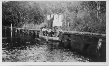
Photograph - B/W, C 1933
The photo shows the Wannon River in flood. Augustus (Gus) Knight built the footbridge. The boat was constructed using kerosene tins or honey tins.Photo shows five adults, four standing and one squatting, on a foot bridge. There are four children in front of them in a boat.structures, bridges -
 Kiewa Valley Historical Society
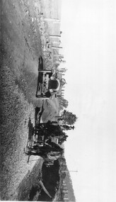
Photo: Making of Kiewa Valley Highway at Tawonga
The Kiewa Valley Highway was/is a major road along the Kiewa River ending at Mt Beauty the site of the S.E.C.V. town built for the construction of the K.H.E.S.Black and white photo with roofless old car beside two horses pulling a cart with man behind the cart. All coming towards the photographer on a road with paddocks on each side.kiewa valley highway, road building -
 Orbost & District Historical Society
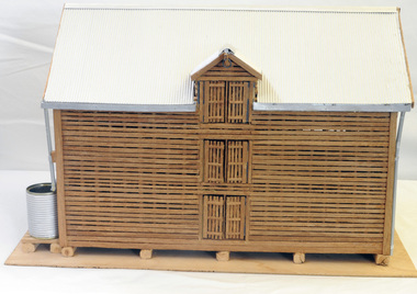
model, Hodge, Chris, 2006
This model was inspired by the Morgan barn on the Marlo Road, Orbost. It was built by Chris Hodge for the launch of the book, "Barns of the Snowy River" ( Reg. No.2138)The slatted barns are unique to the Orbost district.A wooden model of a three-storeyed slatted barn. The scale is approximately 30:1.The roof is corrugated cardboard painted silver. The waater tank is a tin can covered with corrugated cardboard. The down pipes are made from drinking straws. It stands on ply board.model handcraft woodwork barn -
 Tatura Irrigation & Wartime Camps Museum
CD, 1961 State Rivers and Water Supply Commission Water Loss Report to Victorian Government Public Works Committee
Donor F.L. Burns was a design engineer with State Rivers and Water Supply Commission and wrote, as part of a report, "methods of reducing seepage losses".Silver disc. Black text. Inside a black and clear plastic rectangular cover.irrigation, victoria state rivers and water supply commission -
Tatura Irrigation & Wartime Camps Museum
Folder, Articles on History of Waranga Basin, 2000
Extract from Waranga News on early history of Waranga Basin. Maps. Other stories of families at Basin, Goulburn River and Goulburn WeirBlue cover. Black spiral spine. White label. Title in blue penhistory of waranga basin, knee l, tatura, irrigation, books, history, local, rural -
Tatura Irrigation & Wartime Camps Museum
Book, First Overlanders - Hawdon and Bonney, 1991
Written to commemorate the early drovers and the use of river crossing near Wentworth, NSW. The route was later used by noted explorers - Eyre and Sturt.Pale green front cover depicting inscription on Hawdon monument at Wentworth, NSW.first overlanders, first cattle drive, k kain, wentworth nsw, eyre and sturt explorers -
 Vision Australia
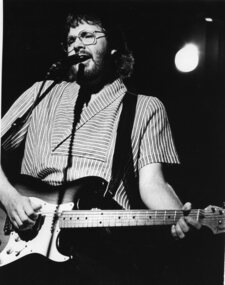
Photograph - Image, Portrait of Graeham Goble
Musician Graeham Goble performs at an unknown event, possibly supplied for the Carols by Candlelight program when the Little River Band played in 1982.B/W photograph of Graham Goble.carols by candlelight, graeham goble -
 Port Fairy Historical Society Museum and Archives
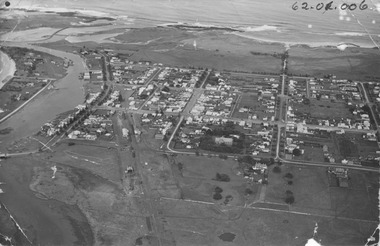
Photograph, 1940's
The photograph depicts the river, bridge, rail line, Regent Street, Sackville Street, William Street and south west passage and pudney groundsSignificant for its depiction of the layout of the town in the 1940's and the river and south west passageBlack and white photograph Oblique Port Fairy Streets looking SouthALEX WILKINS PHOTOGRAPHER WARRNAMBOOL O.G.Powell Chemist Phone 88 Port Fairy Handwritten- Aerial View to be enlarged to 12" wide underlined 62.01.006 written on front of picturemoyne river, sackville street, william street, south west passage, pudney gorunds -
 Greensborough Historical Society
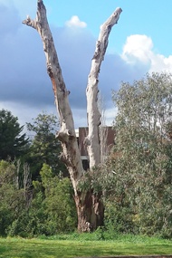
Photograph - Photograph - Digital Image, Marilyn Smith, Greensborough trees 2020, 24/08/2020
Digital image of trees at Greensborough 24/08/2020, This image shows the trimmed trees near the Plenty River and Main Street GreensboroughPart of a collection of miscellaneous historical images with a connection to the local area.Digital colour photograph. plenty river, trees - greensborough -
 Bacchus Marsh & District Historical Society
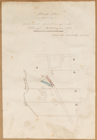
Map, Rough plan showing proposed deviation of road through McKenzie's Flat
The date of this map or plan is uncertain. McKenzie's Flat is a bushland picnic area on the Lerderderg River in the Lerderderg State Park close to Bacchus Marsh. Single page map showing a proposed deviation of the road near the McKenzie's Flat area close to Bacchus Marsh. The proposed deviation is shaded in pink, The existing road section to be replaced is shaded in blue. No scale is indicated. Part of a set of maps which are pasted into a bound volume containing 76 maps or plans in total. High resolution digital image stored on BMDHS computer network. mckenzies flat bacchus marsh, bacchus marsh roads and streets -
 Port of Echuca
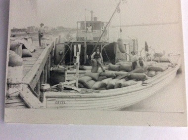
Black and white photograph, Before 1920
The P.S Clyde was built in 1884 by W.Wilson, in Echuca and was owned by the Evans Bros. It sunk in the Murrumbidgee river in 1920 and was raised and converted into a barge in 1922. The barge Excel was built as the Barge Adam in 1897. It was owned by the Permewan Wright Co. and renamed barge 'Excel' in 1909. (Ref ; Parsons, Ronald, "Ships of the Inland Rivers" This photograph must have been taken before 1920 when the P?S Clyde was still a paddle steamer.One of two black and white photographs of the P.S Clyde and the barge Excel moored to a wharf, possibly at Swan Hill. People are on the wharf and both vessels. There is a crane fitted on the Clyde loading, bags of wheat. A woman is standing in front of the wheel house. There is a man inside the wheel house. Steering mechanism appears to be attached at the back of the barge, and there also appears to be a flag flying on the back of the barge. Three men are on the barge supervising the loading process.Written on the back of the smallest photograph are the words "2nd copy in Clyde file." On the barge in the photograph is the word 'EXCEL' 'and the word 'Clyde' can be seen on the bow of the paddle steamer .p.s.clyde, excel, adam, evans bros, murrumbidgee river -
 Orbost & District Historical Society
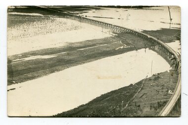
black and white photographs, second half 20th century
3154.1 is a postcard of the Orbost viaduct over the flooded Snowy River flats. 4153.2 is of a goods train on the viaduct. 3154.3 is of a loaded goods train with the driver at the window. Two men are standing on the plate and there are two workers below where there is some water and flood debris. 3154.4 is of amachine moving flood debris on the rail line. 3154.5 shows flood damage to the viaduct across the Snowy River flats. Two men are driving a dozer.This item is associated with the history of the Orbost-Bairnsdale railway line and therefore reflects the role that the rail line played in the social and economic history of Orbost.Five black / white photographs associated with the Orbost railway line during a flood.orbost-railway east-gippsland -railway orbost-floods -
 Kiewa Valley Historical Society
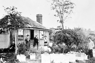
Photographs – Set of 4 black and white photographs. One of a wooden church and three of rural homes and farmland. Area not identified
Europeans arrived in the Kiewa and Ovens Valleys in the 1830's and 40's. Following the drought of 1838-44, seeking out the rich pastures in the fertile Valleys. It proved to be perfect conditions for dairy farming and the raising of cattle. Miners Cottages and other similar wooden structures were a common sight in the area as they were a modest form of accommodation for their period, were quick to erect and economical as they made use of locally available building materials such as local timbers.These photographs provide a snapshot into the early dwellings and architecture of the Kiewa and Ovens Valley regions, including buildings such as the church, which provided an important gathering place for social interaction, especially in these isolated areas.1-Wooden church building with no identification. Large tree in the foreground in front of church 2&3- Black and white photographs of farmland and assorted dwellings, mostly miners style cottages in a valley with mountains in the background. A bridge with wooden railings is visible over the river in the middle of the photograph, also a more modern dwelling is visible in the north east of the photograph close to the river. 4-Black and white photograph of residential homes and farmland with an unsealed road running through the middle. Foreground shows a field which has been semi cleared of trees (stumps remaining). In the background are larger farming properties with the road disappearing into the distant hills. This might be Old Tallangatta before the town was moved in 1956. 1-3 - No inscriptions 4- Signature written on back in lead pencil - Sandra Templebuildings; church; farmland -
Port Melbourne Historical & Preservation Society
Photograph - Photograph board, Seven aerial views of J Kitchen & Sons site, Port Melbourne, J Kitchen & Sons Pty Ltd. Port Melbourne 1951, 1951
Large brown cardboard with seven (7) B&W aerial photographs pasted on it. Taken in 1951. Photo 1 - South East direction with Boundary Street in foreground, Kitchens buildings and Football Ground (cricket being played) Photo 2 - South West direction towards the Bay showing Station and Princes Piers, with ships in the distance. Photo 3 - almost directly above Kitchens Photo 4 - directly above kitchens Photo 5 - looking West including the Yarra River Photo 6 - looking North with Kitchen's storage and football ground in foreground Photo 7 - looking north east with football ground in foregrpound left and Yarra River top right.industry - manufacturing, built environment - industrial, piers and wharves - princes pier, piers and wharves - station pier, sport - australian rules football, sport - cricket, sport - recreational grounds, j kitchen & sons pty ltd, port melbourne football and cricket ground, north port oval -
 Kew Historical Society Inc
Album - Photograph Album No.2, Henry Beater Christian, 1928-30
Henry Christian (c.1809-91), the grandfather of the photographer, was one of the first settlers in Kew. He arrived in Victoria with his wife Agnes and son Orlando in 1855 on the Gypsy Queen. He established a rope-making business in Bulleen Road by 1858 but was declared insolvent two years later. In his final years, he was celebrated as one of the oldest living settlers of the district. His son, Orlando Henry Beater Christian (c.1853-1930) became a member of the Hawthorn Band and a foundation member of the Willsmere Swimming Club. Orlando and his wife Elizabeth had four children of which Henry Beater Christian (1886-1962) was the eldest.An album of photographs, compiled by Henry Beater Christian (1886-1962) of Pakington Street, Kew, depicting individuals, natural and settled environments and the interactions between these worlds. Henry Christian, was a keen explorer, not just of his immediate environment but also of the Victorian wilderness. His major opus is contained in two albums in which he records, sometimes in majestic detail and on other occasions the intimate features of the natural world. His photographic travels during the 1920s, often in solitary ramblings but on other occasions with companions, recall the heroic landscape photography of an earlier era, pioneered by Nicholas Caire. In addition to their aesthetic value, the albums are historically significant records within the State of Victoria, of what is now a distant point in time, and of places that have become radically altered through human intervention.Digital copy of a photograph 24-page album loaned by Diane Washfold with permission given to photograph and hold a copy in our collection. The album contains series of photographic positives taken by Henry Christian (a resident of Pakington Street), of places in Kew and throughout regional Victoria during the late 1920s. The mainly sepia photographs, while small, are of a very high resolution. Photographs are typically lightly glued onto pages. Individual pages may be identified by white ink, which in a number of cases is illegible due to wear. Identifiable locations include: Walhalla, Thomson River, Aberfeldy, Matlock, Jericho, Jordan River, Jamieson, Harrietville, Mt Feathertop, the Alpine Road, Cape Patton, Melbourne, and Kew.henry christian (1886-1962), landscape photography, photograph albums, walhalla (vic.) -- history —— photographs, thomson river (vic.) — history —— photographs, aberfeldy (vic.) -- history —— photographs, matlock (vic.) -- history —— photographs, jericho (vic.) -- history —— photographs, jordan river (vic.) -- history —— photographs, jamieson (vic.) -- history —— photographs, harrietville (vic.) -- history —— photographs, mt feathertop (vic.) -- history —— photographs, alpine road (vic.) -- history —— photographs, kew (vic.) — history—— macauley’s boathouse — photographs, kew (vic.) —— history - kew lunatic asylum — photographs, kew canoe club history — — photographs, cape patton — history— photographs, coronation — george vi — melbourne (vic.), christian-washfold collection -
 Melbourne Tram Museum
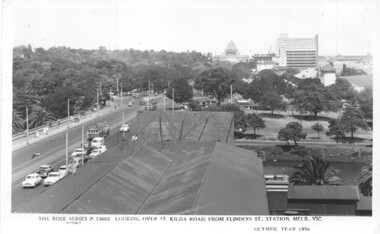
Postcard, Rose Stereograph Co, Flinders St station clock tower looking south towards the Shrine, 1956
Postcard - Rose Series black and white of the view from the Flinders St station clock tower looking south towards the Shrine. Shows St Kilda Road, Prince Henry's Hospital, the Yarra River and the gardens on the south side of the river. Has two trams in the view. On the lower edge of the card "The Rose Series P13602 Looking over St Kilda Road from Flinders St Station Melb. Vic" and "Olympic Year 1956". On the rear is a note written to Keith from Ken of Barkly St Mornington on 14/1/58 mainly about a Pat Lyton? now a tram conductor at Hanna St and a meeting with Brian. Has some personal notes about Pat.trams, tramways, flinders st, postcards, st kilda road -
 Bendigo Military Museum
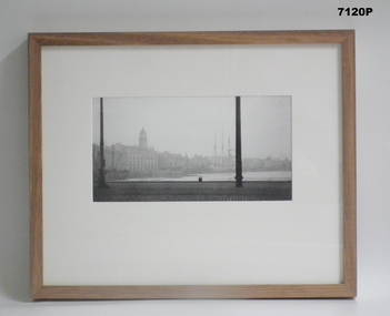
Photograph - PHOTOGRAPH - FRAMED WW1, Wayne Eels, C.2008/2009
The Grinton Collection. The Port of Le Harve, port city on the Seine River northern France. Refer Cat No. 1280 for Jack Grintons service details. Photograph framed. Photograph - black and white photograph on paper depicting a port scene, foreground - paved area with lamp posts, water. - background - ships, some with masts, with buildings behind. Frame - timber, light varnish finish, Perspex front, cardboard backing."Group 3: Trip of a Lifetime" "H. Port of Le Havre".framed accessories, camera on the sommne, ww1, 38th bn, grinton, le havre -
 Eltham District Historical Society Inc
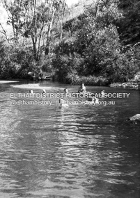
Photograph - Negative, Lewis Tulk, Possibly Seymour based Scouts, c.1980
Believed to be Seymour Scout group enjoying water activities in the Goulburn River Donated by Lewis Tulk, former Scout Area Training Commisioner for Leaders.scouts victoria, scout leader training, lewis tulk collection, yarra batman area, goulburn river, seymour -
 Eltham District Historical Society Inc
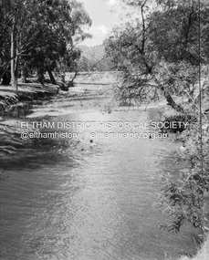
Photograph - Negative, Lewis Tulk, Possibly Seymour based Scouts, c.1980
Believed to be Seymour Scout group enjoying water activities in the Goulburn River Donated by Lewis Tulk, former Scout Area Training Commisioner for Leaders.scouts victoria, scout leader training, lewis tulk collection, yarra batman area, goulburn river, seymour -
 Eltham District Historical Society Inc
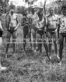
Photograph - Negative, Lewis Tulk, Possibly Seymour based Scouts, c.1980
Believed to be Seymour Scout group enjoying water activities in the Goulburn River Donated by Lewis Tulk, former Scout Area Training Commisioner for Leaders.scouts victoria, scout leader training, lewis tulk collection, yarra batman area, goulburn river, seymour -
 Eltham District Historical Society Inc
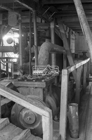
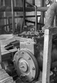
Photograph, George Coop, Steam plant of paddle steamer 'Adelaide' at Echuca, c.1962
PS 'Adelaide' was later turned into a display in the park surrounded by rose bushes for around 20 years before being restored and returned to the Murray River.Digital TIFF file Scan of 35mm Ilford FP3 black and white negative transparencygeorge coop collection, echuca, paddle steamer, ps adelaide, steam engine -
 Eltham District Historical Society Inc
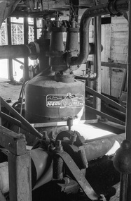
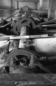
Photograph, George Coop, Steam plant of paddle steamer 'Adelaide' at Echuca, c.1962
PS 'Adelaide' was later turned into a display in the park surrounded by rose bushes for around 20 years before being restored and returned to the Murray River.Digital TIFF file Scan of 35mm Ilford FP3 black and white negative transparencygeorge coop collection, echuca, paddle steamer, ps adelaide, steam engine -
 Greensborough Historical Society
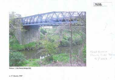
Photograph - Photograph (Copy), Anne Paul, Old Plenty Bridge Lower Plenty, 2003_05
Various views of entry into Lot 2A Main Road Lower Plenty, now Edward Willis Drive, including the old Plenty River Bridge.3 colour photographs printed on paper, handwritten or typed captionslower plenty, main road lower plenty, edward willis drive lower plenty, plenty river bridge, plenty river forum -
 Greensborough Historical Society
Article - Memoir, June Roberts, Brian and June Roberts at 'Blackjack', 1956o
Brian and June Roberts moved to Hume Street Briar Hill as newlyweds. June's story recounts the development of their home on the Plenty River and the friendships with neighbours. A primary source recollection of Greensborough in the mid to late 20th century.11 typed pages.june roberts, brian roberts, briar hill, blackjack, hume street, suburban life -
 Greensborough Historical Society
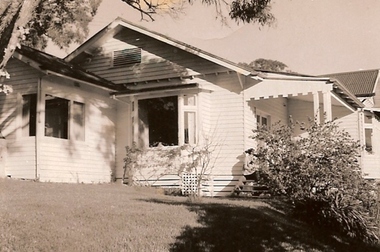
Photograph - Digital Image, Mitchell's house, 1910c
The Mitchell house was situated in Hailes Street on land that went to the river. Part of this land is now the skate park in Yando Street off Kalparrin LaneDigital copy of black and white photograph.mitchell family, hailes street greensborough -
 Greensborough Historical Society
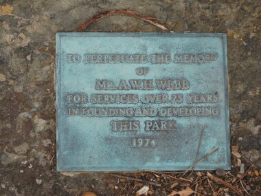
Photograph - Digital image, Dennis Ward, Plaque - A. H. W. Webb, 27/03/2010
Plaque on Plenty River Trail at Greensborough: "To perpetuate the memory of Mr A. H. W. Webb for services over 25 years in founding and developing this park".Sign from the early development days of the Plenty River Trail.Digital copy of colour photographs.plenty river trail, a h w webb -
 Greensborough Historical Society
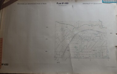
Map, Melbourne & Metropolitan Board of Works, MMBW Plan No.480, 17/10/1949
MMBW plan of part of central Greensborough, from Plenty River in North to Grimshaw Street in South, Sellars Street in West to Kerr Street in East.Map shows buildings and topography for the area.MMBW plan, black and colour ink on beige parchment, 4 copies."Scale:160 feet to 1 inch"melbourne and metropolitan board of works, mmbw, greensborough -
 Greensborough Historical Society
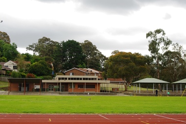
Photograph - Digital Image, Marilyn Smith, Willinda Park Buildings and facilities, 06/11/2017
Willinda Park is situated in Beatrix Street Greensborough. It has an athletics track and field and is adjacent to the Plenty River. These photographs show some of the facilities at the park.Digital copy of colour photographwillinda park, beatrix street greensborough, athletics