Showing 7072 items
matching snowy-river
-
 The Beechworth Burke Museum
Photograph, c.1927-1930
This image shows the Punt (a kind of small boat) that took residents of Bethanga across the Murray River before the Bethanga Bridge was built. Bethanga Bridge was built between 1927 and 1930, and was made a necessity by the building of the Hume Dam. The Hume Dam, formerly known as the Hume Weir, was in construction between 1919 and 1936, which swelled the Murray River into the floodplain to the East of the dam permanently, creating Lake Hume, and isolating the residents of Bethanga and nearby towns, for whom the trip all the way around the new lake to another river crossing was a massive undertaking. The person who wrote on the back of this card instead chose to cross the river on a boat until the Bethanga Bridge became available. Interestingly, partially submerged trees can be seen in the lake in the background of this photograph, illustrating that the dam had already begun to fill the floodplain even before the bridge was built. This photograph shows the methods the residents of Bethanga used while the Bethanga Bridge was being built. This record is associated with the Heritage Listed sites of the Hume Dam and the Bethanga Bridge, and shows the environment during the process of construction and the creation of Lake HumeSepia rectangular photograph printed on matte photographic paperReverse: 1997.3189 / 84 -19 -1 / This is the snap of the Punt. / Our only means of getting out / of Bethanga for the present / Until the bridge is completed / it is 2 miles above the junction / of the Mitta + Murray. It is / 1/2 a mile wide + runs across / the Murray into NSW / Kodak Print / bethanga, bethanga bridge, hume, hume dam, artificial lake, lake hume, hume weir, flood, floodplain, boat, punt, weir, pier, dock, transport, transportation -
 Greensborough Historical Society
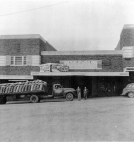
Photograph - Digital image, Stubley's Hay and Grain Store, 1937c
Stubley's Hay and Grain Store circa 1950. The Stubley Group began in 1946 when Purcell Stubley purchased a site with petrol bowsers in Main Street from 'Snowy' Jessop. In 1948 Purcell began building the new Stubley Motors, working round the old site to keep the business operating. It was completed in 1951. The Group expanded into other areas such as this Hay and Grain Store, to serve the semi-rural area of Greensborough and surrounds.Digital copy of black and white photographpurcell stubley, stubley motors, stubley group greensborough -
 Port of Echuca
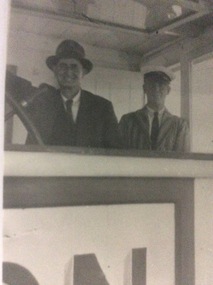
A black and white copy of a photograph, 24/09/1984
During the Second World War the P.S Marion operated as a passenger vehicle up and down the Murray River.This is a photograph showing Hugh Price steering the P.S. Marion while the Captain looks on! This photograph is linked to P000067, P000065 as they are all part of the Hugh Price Family collection.A copy of a black and white photograph of Hugh Price and Captain George Makins in the wheelhouse of the P.S Marion.In pencil, written on the back is Price / Oct 43 / Capt. Geo Makins, (in cap) & Hugh Price.p.s marion, hugh price, captain george makins, george makins, 1943, price family collection -
 Greensborough Historical Society
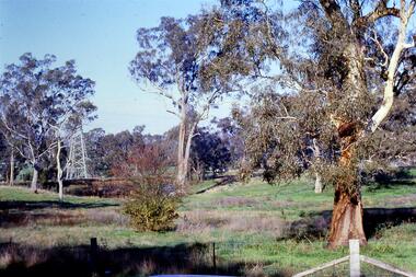
Slide - Photograph, John Ramsdale, Near the confluence of the Plenty and Yarra Rivers, Lower Plenty: Slide 118, 1990s
Photograph shows a rural scene with gumtrees and pylon. This is near the confluence of the Plenty and Yarra Rivers, Lower PlentyPart of the John Ramsdale collection of slides and audio visual material.Colour photograph scanned from slide.No maker's marks. No caption on slide.yarra river, plenty river, lower plenty -
 Greensborough Historical Society
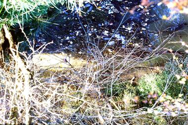
Slide - Photograph, John Ramsdale, Sprayed blackberries: Slide 18, 1990s
Photograph shows sprayed and dead blackberries on the bank of the Plenty River; behind factories on Para Road Montmorency.Part of the John Ramsdale collection of slides and audio visual material.Colour photograph scanned from slide.No maker's marks. No caption on slide.plenty river, weeds, blackberries, para road montmorency -
 Greensborough Historical Society
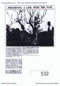
Article, Argus (newspaper), Preserving a link with the past, 08/09/1937
1937 article describing the Apple Tree on Plenty River at Greensborough, its possible origins and steps to preserve it.Early attempts to preserve the Batman Apple Tree and alternative explanations of its origins.Downloaded copy of article. Text and b&w photo. batman apple tree, flintoff, plenty river, greensborough -
 Kiewa Valley Historical Society
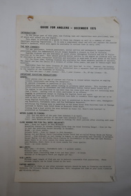
Paper - Fishing Guide, Guide for Anglers - December 1975
Ron White Collection. Fishing still is a popular sport in the Kiewa River where competitions are frequently held.Ron White was a keen fisherman and the Kiewa River was famous for its fishing. See KVHS 1282.Two sided foolscap paper titled 'Guide for Anglers - December 1975'.ron white, angler fishing, kiewa river -
 Eltham District Historical Society Inc
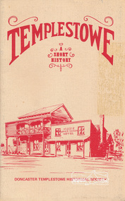
Book, Doncaster Templestowe Historical Society, Templestowe: A Short History by Irvine Green, 1982
Templestowe is a suburb in the City of Manningham on the border of the Yarra River across from which is Eltham, in the Shire of Nillumbik24 p. : ill., 3 maps ISBN 0950092037templestowe -
 Federation University Historical Collection
Ethnographic Material, Aboriginal Hammer
A hammerstone is a lump of stone or river coble used in fashioning small stone tools for providing food stuffs.A mudstone in a cylindrical prism shape. It is rather flat at one end, where ther is also evidence on the side stone having been flaked away. The other end is also flattish but more pointed.hammer, aboriginal, stone, ethnography, tools -
Tatura Irrigation & Wartime Camps Museum
Folder, State Rivers & Water Supply Commission - Permanent Staff 1939 -1944, Temporary Staff 1943
Recording of State Rivers & Water Supply Commission permanent staff 1939-1944 and temporary staff 1943Brown folder, white label, blue writing.irrigation, documents, reports -
Tatura Irrigation & Wartime Camps Museum
Audio Tape, 75th Anniversary of the formation of the State Rivers & Water Supply Commission. Sir Ronald East the guest speaker
75th Anniversary of the formation of the State Rivers & Water Supply Commission. Sir Ronald East the guest speaker.audio, visual, technology, accessory -
 Peterborough History Group
Photograph - Four copies of photographs of the Peterborough Old Bridge
Varying views of the old bridge, which was a valuable connection to the East side of the river. A view of the landscape at that time.Historic views of the town and bridge 4 photocopied reproductions of different aspects of the Old bridge at Peterborough, including one which is a copy of The Rose Series Postcards No P2470.peterborough, peterborough old bridge, curdies river bridge, rose series postcards, rose series p2470 -
National Wool Museum
Book, John Drysdale and the Burdekin
"John Drysdale and the Burdekin" -Roy Connolly, 1964. Includes "Burdekin River sketchbook" 16pp, by Russell Drysdale.agriculture wool growing, agriculture, wool growing -
National Wool Museum
Shoes
Australian womens shoes from the formal uniform for the Sydney 2000 Olympic Games. Manufactured by Rivers Shoes.fashion, woolmark company rivers shoes, sport, the woolmark company 2000 australian olympic display - exhibition (21/12/2001 - 24/05/2002) -
National Wool Museum
Shoes
Australian mens shoes from the formal uniform for the Sydney 2000 Olympic Games. Manufactured by Rivers Shoes.fashion, woolmark company rivers shoes, sport, the woolmark company 2000 australian olympic display - exhibition (21/12/2001 - 24/05/2002) -
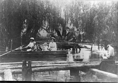 Kiewa Valley Historical Society
Photo - Water Wheel and Punt on the Kiewa River - Tangambalanga Homestead
In early times, Homesteads were part of pastoral runs many of which had frontage onto a river.Tangambalanga Homestead, on the Kiewa River, was subdivided in 1862 from T. Mitchell to Thomas BrownBlack and white shiny photo with women and children in a boat on 'flood' waters and a woman on the bank near a footbridge or jetty. The ladies are wearing hats, long skirts and blouses. In the background there is a large water wheel and trees. This photo is published on Page 19 of 'A History of the Kiewa Valley' by Esther Temple and David Lloyd.tangambalanga homestead, water wheel on the kiewa river, punt on the kiewa river -
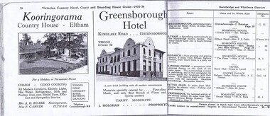 Greensborough Historical Society
Magazine - Advertisement, Greensborough Hotel Advertisement 1933-34, 1933-1934
An advertisement for Greensborough Hotel in the town of "Greensborough, picturesque township on the Plenty River, 13 miles from Melbourne."Photograph show the "new brick building with all modern conveniences'. Greensborough in the 1930s was a popular spot for picnics and holidays.2 pages from a Victorian Railways travel journal. Advertisement for Greensborough Hotel 1933-34. Photocopy from original journal.greensborough hotel, greensborough -
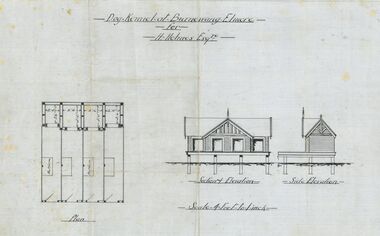 Bendigo Historical Society Inc.
Plan - Architectural drawings for Burnewang Homestead, Elmore, No date visible
Burnewang was built in 1903 for the Holmes Family. It is situated on the banks of the Campaspe river a few kilometres east of Elmore.Set of five Architect drawings of the Burnewang, Elmore Homestead showing, Elevations, Floor plans, Garden Layout, Details of the Fencing and the Dog Kennel. The plans were prepared for H Holmes.H. Holmes Esq.buildings, house, architect drawing, burnewang, elmore, holmes -
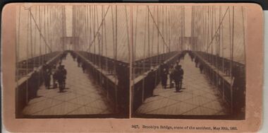 Bendigo Historical Society Inc.
Photograph - HARRIS COLLECTION: STEREOSCOPIC VIEWS, Nineteenth Centur
Stereoscopic views. Kilburn Brothers Littleton , N H. 1. Trinity college Dublin. 2. Brooklyn Bridge, scene of the accident , May 30th 1883. 3. Spinning Room , Mechanics Mill, Fall River Mass. 4. Bay Grove Hill, Greenwood Cemetery, Brooklyn, N Y. 5.Crossing the Great Suspension Bridge, by rail. 6. Dining Hall , Grand Union Hotel, Saratoga, Largest Dining Hall in the World. 7. Phantom Leaves. 8. Full Moon. 9. Merced River, Yo-Semite , Cal. 10. I Breathe Inspiration. 11. United States Hotel Park, Saratoga.Kilburn Brothers Littleton N H.photography, viewers -
 Bendigo Historical Society Inc.
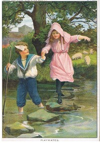
Document - MALONE COLLECTION: GREETING CARDS, 15/1/1910
Coloured picture of a boy wearing a blue & white sailor suit paddling across a stream. He is holding a girl's hand as she walks over the stepping stones in the stream. She is wearing a pink dress & hat and black stockings & shoes. The boy has a pole in his hand. On the bank of the stream is a large tree and some grazing sheep. At the back is a grey building. The picture is mounted on cardboard. 'Horner's Magazine, River of Life Series, MP274, MP275, MP276, & MP277 is written in pen on the back. The picture is titled 'Playmates'. At the top of the picture is printed 'zhorner's Penny Stories 'River of Life' Series No 1. 15.1.1910.personal effects, greeting cards, malone collection, malone collection, greeting cards, horner's magazine river of life series -
 Kew Historical Society Inc
Photograph - Demolishing the Zig-Zag Bridge, 1929
Henry Beater Christian (1886-1962) , was a descendant of one of the earliest settler families in Kew. Employed at the Kew Asylum as a 'public servant', he was a skilled amateur photographer, photographing numerous scenes in Kew and on his travels around Victoria. The majority of his photographs date from 1916 to 1929. His finest photographs are housed in two photograph albums. Rare photograph of the demolition of the Zig-Zag Bridge linking the two asylums on either side of the Yarra River.Digital copy of a photograph from page 16 of the 47-page photograph album containing 261 gelatinous silver images, loaned by Diane Washfold with permission given to digitise and hold a copy in our collection. The Zig-Zag Bridge linked the grounds of the Yarra Bend and Kew Asylums. The wooden bridge was constructed in the 1870s and lasted through numerous floods until its destruction in 1929. A horizontal structure, the walkway was reached via a wooden staircase on the Kew bank of the river. The steps were required due to the different levels of the banks on this stretch of the river. This night-time photograph shows the remaining parts of the bridge being destroyed by fire."Demolishing Zig-Zag / 6. 1929"henry beater christian (1886-1962), landscape photography, kew (vic.) — yarra river, christian-washfold collection, photograph albums, zig-zag bridge -
 Kew Historical Society Inc
Map, MMBW, MMBW Plan No.117 Heidelberg & Kew, 1900-1910
The Melbourne and Metropolitan Board of Works (MMBW) was established by an act of the Victorian Parliament in 1890 to prepare for and to implement a sewerage and water reticulation system across what was then inner Melbourne, its surrounding and middle distance suburbs, including Kew. The MMBW was disbanded in 1991.The map collection of the Kew Historical Society has at its core the historic maps assembled and originally stored in the City Engineer's Department of the City of Kew. These include maps in a number of scales. The vast majority of maps were produced by the MMBW in the first two decades of the twentieth century, and are solid working maps, backed by linen for durability. These maps are historically significant to Kew, the City of Boroondara and to the history of the development of state utilities in Victoria. A number of the Kew maps have additional details added by former municipal officers, including the levels reached by various floods. As these were working documents, information was added to them long after the period of their initial production and distribution.Early map of part of the Borough of Kew, created in the early twentieth century, at a scale 160 ft to 1 inch. The map covers what was then the north eastern part of Kew showing the natural landscape and limited development on the south side of the Yarra River. In the Kew section, south of the river, the land is occupied currently by the Greenacres and Kew Golf Clubs. The map shows the extent of urban development by that time and the outlines of the few built structures in the municipality. The height above sea level of all parts of the landscape are indicated numerically in feet. Contour lines and the levels of historic floods were added in ink to the map at a later stage. MELBOURNE AND METROPOLITAN BOARD OF WORKS / PLAN NO. 117 / HEIDELBERG & KEW melbourne & metropolitan board of works, mmbw maps, borough of kew, cartography, mmbw plan no. 117, kew (vic.) -- maps, heidelberg (vic.) -- maps -
 Wodonga & District Historical Society Inc
Album - Hume Reservoir Australia Album - Excavations for foundations inside coffer dam, January 1927
This set of photos is from a leather bound album bearing the inscription "HUME RESERVOIR AUSTRALIA" plus 'The Rt. Hon. L. C. M. S. Amery, P. C., M .P.' all inscribed in gold. It was presented to The Rt. Hon. L. C. M. S. Amery, P. C., M. P, Secretary of State for Dominion Affairs on the occasion of his visit to the Hume Reservoir on 2nd November 1927. This album is of local and national significance as it documents the planning and development of the Hume Reservoir up to 1927. It was the largest water reservoir in the British Empire. The album records the pioneering engineering work that went into its construction.DEPARTMENT OF PUBLIC WORKS, N.S.W. RIVER MURRAY WATERS SCHEME. HUME RESERVOIR. 21. Excavations for foundations inside coffer dam. New South Wales. January 1927. Cofferdams are temporary structures used where construction is being carried out in areas submerged in water. They are most commonly used to facilitate the construction or repair of dams, piers and bridges. To divert the river, a Coffer Dam was built across the old bed above and below the Dam site and tying into the end of the concrete wall built inside the levee bank. This completely surrounded the remainder of the site of the Dam and south wing wall, including an area of 12½ acres. hume reservoir australia, river murray waters scheme, hume reservoir construction, coffer dam -
![View of the Township of Omeo / [by] Nicholas Caire, circa 1876](/media/collectors/550653872162f11fb04854aa/items/57830e80d0cdd1176c4335ca/item-media/57830eecd0cdd1176c43dd40/item-fit-380x285.jpg) Kew Historical Society Inc
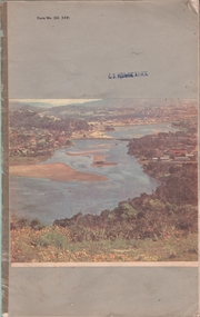
Kew Historical Society IncPhotograph, Anglo-Australasian Photographic Company, View of the Township of Omeo, c. 1876
Nicholas Caire was born on Guernsey in the Channel Islands in 1837. He arrived in Adelaide with his parents in about 1860. In 1867, following photographic journeys in Gippsland, he opened a studio in Adelaide. From 1870 to 1876 he lived and worked in Talbot in Central Victoria. In 1876 he purchased T. F. Chuck's studios in the Royal Arcade Melbourne. In 1885, following the introduction of dry plate photography, he began a series of landscape series, which were commercially successful. As a photographer, he travelled extensively through Victoria, photographing places few of his contemporaries had previously seen. He died in 1918. Reference: Jack Cato, 'Caire, Nicholas John (1837–1918)', Australian Dictionary of Biography.An original, rare photograph from the series 'Views of Victoria: General Series' by the photographer, Nicholas Caire (1837-1918). The series of 60 photographs that comprise the series was issued c. 1876 and reinforced a neo-Romantic view of the Australian landscape to which a growing nationalist movement would respond. Nicholas Caire was active as a photographer in Australia from 1858 until his death in 1918. His vision of the Australian bush and pioneer life had a counterpart in the works of Henry Lawson and other nationalist poets, authors and painters.‘View of the township of Omeo’ : Views of Victoria (General Series) No.44 : Albumen silver photograph | Photo on card with Title and Description on reverse | Mounted 24 x 30 cm; Photo 12 x 17 cm.On Reverse: ‘The subject of this illustration is the most remote Township in the Colony of Victoria, being about 250 miles distant from Melbourne. It is situated on the Australian Alps, near Mt. Livingstone. The bed of the River, which is seen on the right-hand side of the picture, is one of the sources of the Mitchell River, which empties itself in the Gipps Land Lakes. This Township is frequently covered with snow in winter time, owing to its being several thousand feet above the level of the sea.’ nicholas caire (1837-1918), omeo (vic), gippsland, mount livingstone, australian alps -
 Kiewa Valley Historical Society
Calendar 2008
Brief history of the SECV construction town of Bogong which became a tourist town."Memories of Bogong Calendar 2008" Photographs of the physical environment. Front cover has a photograph of a person standing in a river. A short history of 'Bogong 1957-1963' and 'Come visit Bogong Village' a 'celebration of Bogong Village's environment'. 12pp with a hole (to hang up) in the centre bottombogong, calendar, tourism, bogong village, secv, kiewa hydro electric scheme -
 Bendigo Historical Society Inc.
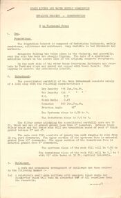
Document - STATE RIVERS AND WATER SUPPLY COMMISSION : EPPALOCK PROJECT - CONSTRUCTION
State Rivers and Water Supply Commission headed six page document, stapled. Subtitled: ' Eppalock Project - Construction. Some Technical Notes.' Information typed under subheadings: Dam, Embankment, Spillways, Outlet works, proposed hydraulic driven pumps, road deviations. Undated.state infrastructure, water supply, coliban system, state rivers and water supply commission. coliban system. eppalock. -
Port Melbourne Historical & Preservation Society
Photograph - Various wharf/pier locations, 1920 - 1922
Original photos. Eighteen loose photos in separate box . Charles Wynn Kiver Allison M.I.E.A.. Namely the New Pier (Princes), Railway Pier, Williamstown, Centre Pier in Victoria Dock, and the Interstate Swinging Basin (near Charles Grimes Bridge) in Yarra River 1920spiers and wharves - miscellaneous, piers and wharves - princes pier, charles wynn kiver allison, victoria dock -
Port Melbourne Historical & Preservation Society
Map - Photographic copy, Unidentified map of Sandridge, c. 1866
Photographic copy of an unidentified (Cox?) Sandridge map 1866 or later, with portions of West Melbourne, Emerald Hill and the Bend. Indicates bay and river soundings 'taken by Commander COX in 1866'. Original appears to have been torn and repaired; resultant lines whited out on copy.Fold lines have been whited out on back; '52'piers and wharves, transport - railways, built environment, maritime, beacons, sandridge lagoon, batteries - defensive, commander cox -
 Bendigo Historical Society Inc.
Document - Various writings by John Ellison
Writings on various topics. Some are glued inside a notebook. Two others are on loose pages. The notebook has a view of a lake/river with several small villages on the banks. location unknown. Topics are: "The Australian Aboriginals", ' The Great Pastland Movement", Problem of Urban Planning" and "the Plea of Youth".On the cover and on the first page a stamp: L.J. Ellison A.I.M.A.australian aborigines, pastoralist movement, urban planning -
Unions Ballarat
In step with Sturt (Don Woodward Collection), Swan, Keith et al, 1979
The book, targeted at school students, covers the years of Sturt's three expeditions. The authors question Sturt's capability as a surveyor and his leadership.Australian history.Graphic book; 115 pages. Dustjacket: plastic covering; brown and white background; black and white map of Sturt's journey along Murrumbidgee and the Murray River; black, gold and white lettering; authors' names and title. Cover: white and black lettering; authors' names and title.btlc, ballarat trades and labour council, ballarat trades hall, sturt, charles, history - australia, australia - explorers