Showing 10880 items
matching land
-
 Greensborough Historical Society
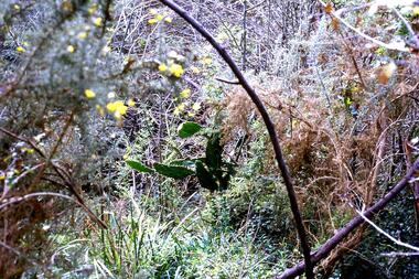
Slide - Photograph, John Ramsdale, Prickly pear, Greensborough: Slide 82, 1990s
Photograph shows prickly pear in bushland near Greensborough. This demonstrates a lack of land care management.Part of the John Ramsdale collection of slides and audio visual material.Colour photograph scanned from slide.No maker's marks. No caption on slide.prickly pear, weeds, land management -
 Greensborough Historical Society
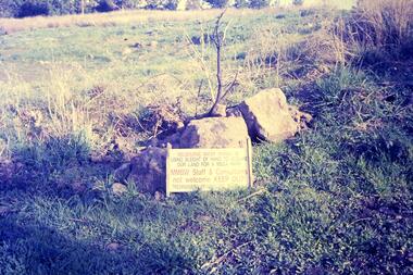
Slide - Photograph, John Ramsdale, Plenty Gorge sign: Slide 50, 1990s
Photograph shows a sign accusing MMBW of taking land for mega park - Plenty Gorge ParkPart of the John Ramsdale collection of slides and audio visual material.Colour photograph scanned from slide.No maker's marks. No caption on slide.plenty gorge metropolitan park, plenty gorge, melbourne and metropolitan board of works -
 Phillip Island and District Historical Society Inc.
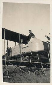
Photograph, Bi-plane on Phillip Island
From Jessie Smith's collection of Island Events & Landscapes. 1st plane to land at Phillip Island.Pilot sitting in Bi-plane. Man in suit welcoming.local history, photographs, transport, aviation, aircraft, phillip island, black & white photograph, jessie smith collection, stan mcfee -
 Mission to Seafarers Victoria
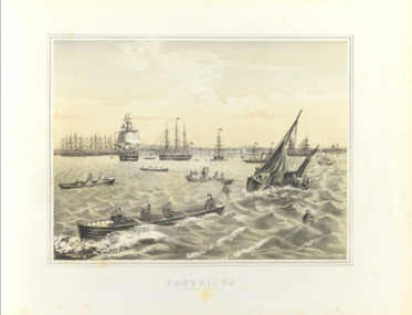
Print - Framed print, Francois Cogne, Sandridge from Hobson's Bay 1863, 1863
Busy port of Melbourne and Sandridge beachfront where the Bethel church was built on the Custom House land.Medium size framed print francois cogne (1829-1883), hobson's bay, sandridge, williamstown, bethel church, reverend kerr johnston, 1812-1887, customs house, artwork-paintings -
 Greensborough Historical Society
Folder of Documents, Nepean Street Greensborough...Purchasers Walter Edwin Kell and others, 2019_
Record of purchases of land on the north side of Nepean Street Greensborough by Walter Edwin Kell and others.Folder containing Certiificates of Title, documents and photographsnepean street greensborough, grace park, kell family, jackson family -
 Greensborough Historical Society
Maps, Plenty River, 1837o
These maps show the land use along the Plenty River. Both Aboriginal and white settlements are shown.Set of maps showing the Plenty River. -
 Eltham District Historical Society Inc
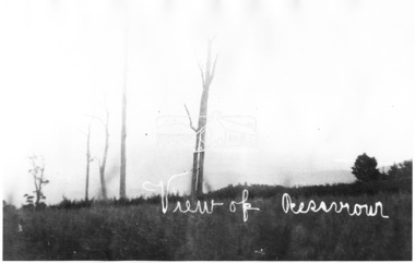
Photograph, View of Reservoir from Kinglake
View is of Yan Yean Reservoir, probably taken from Council land (1970) on Ganglehoffs Road.This photo forms part of a collection of photographs gathered by the Shire of Eltham for their centenary project book,"Pioneers and Painters: 100 years of the Shire of Eltham" by Alan Marshall (1971). The collection of over 500 images is held in partnership between Eltham District Historical Society and Yarra Plenty Regional Library (Eltham Library) and is now formally known as the 'The Shire of Eltham Pioneers Photograph Collection.' It is significant in being the first community sourced collection representing the places and people of the Shire's first one hundred years.Digital image and 4 x 5 inch B&W Negsepp, shire of eltham pioneers photograph collection, kinglake, reservoir, ganglehoffs road, yan yean reservoir -
 City of Moorabbin Historical Society (Operating the Box Cottage Museum)
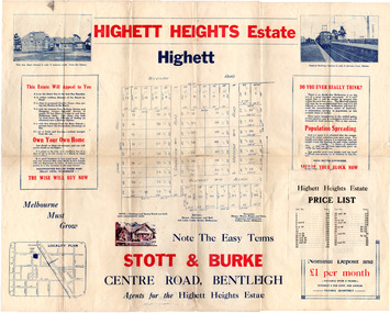
Flyer - Highett Heights Estate, Highett
Land sales in the Municipality of Moorabbin increased when the train line from the City to Frankston was electrified.Example of the progress of the Municipality of MoorabbinAdvertising flyer for auction of real estate sales - plan of building blocks for saleHighett Heights Estate, Highett - Stott & Bourke 58 home siteswickham road, hillcrest avenue, grandview road (now seaton road), maroona road, spring road, real estate, highett, moorabbin -
 City of Moorabbin Historical Society (Operating the Box Cottage Museum)
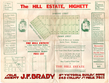
Flyer - Hill Estate, Highett
Land sales in the Municipality of Moorabbin increased when the train line from the City to Frankston was electrified.Example of the progress of the Municipality of MoorabbinAdvertising flyer for auction of real estate sales - plan of building blocks for saleThe Hill Estate, Highett - 24 Housing Blocks - J. F. Bradypoint nepean road (nepean highway), turner street, sanford street, real estate, highett -
 City of Moorabbin Historical Society (Operating the Box Cottage Museum)
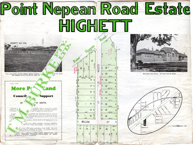
Flyer - Point Nepean Road Estate, Highett, 1937
Land sales in the Municipality of Moorabbin increased when the train line from the City to Frankston was electrified.Example of the progress of the Municipality of MoorabbinAdvertising flyer for auction of real estate sales - plan of building blocks for sale, pictures of landmarks.Point Nepean Road Estate, Highett T.M. Bourkepoint nepean road (nepean highway), alison street, william street -
 Tatura Irrigation & Wartime Camps Museum
Folder, The Transportation of Members of the Temple Society to Australia, 1991
Compilation of day to day life of Templers from the Holy Land to an unknown destination and of their internment in AustraliaBlue cover with title printed on, covered by clear plastic on front and white cardboard on back which extends over the spine and onto the front by 1.5 cm. 62 printed pages.1991 bottom of front coverww2 camp 3, transportation of members of the temple society to australia, temple society, diary of transportation of temple society, erhard gohl -
Clunes Museum
Document - REPORT, ABBEY CARMICHAEL, THE HISTORY AND GRADUAL EVOLUTION OF QUEENS PARK CLUNES FROM 1900 TO THE PRESENT DAY, NOVEMBER 2006
PROJECT BY ABBY CARMICHAEL, A STUDENT IN THE FACULTY OF LAND AND FOOD RESOURCES, UNIVERSITY OF MELBOURNE, NOVEMBER 2006THE HISTORY AND GRADUAL EVOLUTION OF QUEENS PARK, CLUNES FROM 1900 TO THE PRESENT DAY, IN A BLACK - BOUND FOLDER.document, local history, queens park -
 Ballarat Heritage Services
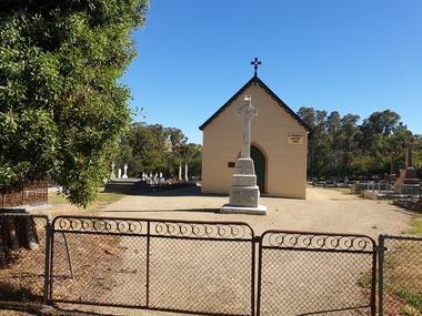
Photograph - Photograph - Colour, Clare Gervasoni, St Francis Xavier Chapel, Eganstown, 2021, 29/1/2021
The St Francis Xavier Chapel and Catholic Cemetery was established on land donated by squatter John Egan.St Francis Xavier Chapel, the chapel in the Eganstown Catholic Cemetery. The grave stone at the front of the church is for John Egan. st francis xavier chapel, eganstown, 1999, eganstown catholic cemetery, eganstown, church, chapel, cemetery, john egan -
 Tatura Irrigation & Wartime Camps Museum
Folder, Die Verschleppung von Mitgliedern Der Tempel Gesellschaft Nach Australien Zur Internierung, 1991
Compilation of day to day life of Templers from the Holy Land to an unknown destination and of their internment in AustraliaBlue cover with title printed on, covered by clear plastic on front and white cardboard on back which extends over the spine and onto the front by 1.5 cm. 62 printed pages. (title translates to The Transportation of Members of the Temple Society to Australia for Internment).1991 bottom of front coverww2 camp 3, transportation of members of the temple society to australia, temple society, diary of transportation of temple society, erhard gohl -
 Bendigo Historical Society Inc.
Administrative record - Exhibition Prize Schedule
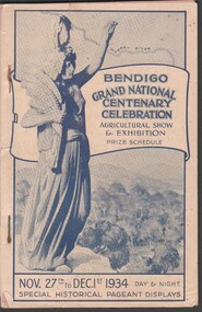
The Show and Exhibition was held to mark the Centenary of the first cultivation of land by Edward Henty at Portland in 1834.Bendigo Grand National Centenary Celebration Agricultural Show & Exhibition Prize Schedule. Booklet - 112 pp. Stapled together. Illustrated front page. Exhibition Prize Schedule for the Show & Exhibition held from 27th November to 1st December 1934 - Day and Night. The booklet lists the exhibition categories and includes advertisements for local businesses.agriculture, centenary, exhibition -
 Kew Historical Society Inc
Photograph - [Series], 2 Tara Avenue, Kew, 2018, 07/09/2018
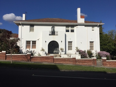
This two storey Spanish mission house was built on land originally part of the Tara Hall Estate.Two storey house at 2 Tara Avenue, sold in 2018 and to be demolished in 2020.kew (vic) - houses - demolished, 1 tara avenue - kew (vic) -
 City of Kingston
Pamphlet - Colour, Allan's Estate Highett, 1930s
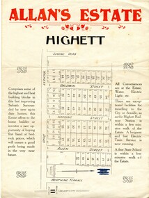
Sales plan for land in the suburb of Highett, bounded by Spring Road, Highett Road and Worthing Terrace.The developing urban area of Highett within the City of Kingston. This land sale pamphlet illustrates the subdivision of land within the municipality and the changing demographic of the district as new houses are constructed.Colour pamphlet advertising Allan's Estate, Highett. Incorporates a map of the estate bordered by Spring Road, Highett Road and Worthing Terrace.Handwritten in grey pencil on reverse: Allan's Estate / Highett Crossed out in blue pencil on front: Name and address of what appears to be a solicitorhighett, land sales, estate -
 City of Kingston
Pamphlet - Black and white, Stott & Burke, Highland Estate Bentleigh, c.1915
Sales plan for land in the suburb of Bentleigh, along Collins and Ross Streets, bounded by Jasper Road.The developing urban area of Bentleigh within the City of Kingston. This land sale pamphlet illustrates the subdivision of land within the municipality and the changing demographic of the district as new houses are constructed.Black and white pamphlet advertising for private sale the Highland Estate, Bentleigh. Incorporates a map of the estate between Collins St and Ross St, bordered by Japser Road. Handwritten in grey pencil on map: additional subdivisions numbered 15-19 drawn along Ross St Handwritten in grey pencil on map: indecipherable annotations to subdivisions 1, 3 and 14land sales, bentleigh, estate -
 Charlton Golden Grains Museum Inc
Photograph, Bendigo Bank, High St Charlton c. 2002
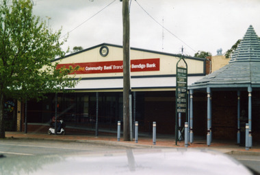
Bendigo Bank built on land formerly occupied by Clark's Butcher Shop. Branch opened in 2003.Colour photograph of Bendigo Bank building. Single storey brick building. Signage is partially obscured by tree and reads 2003 Charlton & District Community Bank Branch Bendigo Bank. Blue timber covered entrance to the Traveller's Rest complex on the RH side. Person going past on mobility scooter. Green signage for Traveller's Rest reads CAFES BAKERY PUBLIC TOILET CHEMIST HOTELS MOTELS SUPERMARKETS NEWSAGENCY.charlton, bendigo bank, business, industry, clark's butcher -
 Linton and District Historical Society Inc
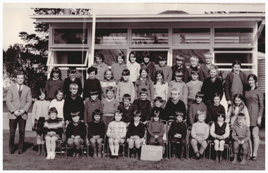
Photograph, Mannibadar State School Pupils, 1970
Mannibadar State School No. 4446 opened in July 1929, on land purchased from W. Kerr.Black and white photo of pupils and teachers at Mannibadar State School in 1970.mannibadar state school no. 4446 -
 Greensborough Historical Society
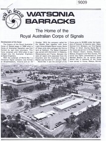
Article - Article, Newsletter, Watsonia Barracks: the home of the Royal Australian Corp of Signals
A short history of the Royal Australian Corps of Signals at Watsonia Barracks, including background history of the land.Printed article with black and white photos, 3 pageswatsonia army barracks, simpson army barracks -
Canterbury History Group
Map - Canterbury Subdivisions
A collection of 6 maps with notations showing the names and dates of land subdivision in Canterbury and surrounding suburbs.canterbury, logans estate, shrublands estate, claremount park estate, arklow hill estate, griffin estate, monomeath estate, mont albert park estate, great railway estate, grange estate -
 Lakes Entrance Historical Society
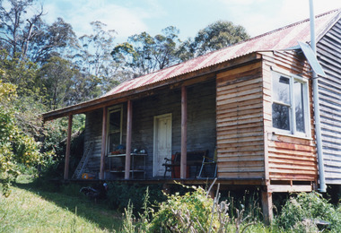
Photograph - The Bee Farm, 1999
Land selected 1888 by A F Petersen who kept bees. First house was a bark hut.Colour photograph taken at Mrs Maisie Byrnes home The Bee Farm, showing an unpainted timber cottage set in old farm clearing, at Byrnes Track Toorloo Arm Victoriahouses, heritage study -
 Ringwood and District Historical Society
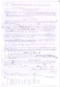
Document - Contract, Ringwood Property Sale from Thomas Grant to Walter and Philip Bamford 1908 (cnr Whitehorse Road and Warrandyte Road), 1908
The transfer of land in Ringwood from Thomas Grant to Walter and Philip Bamford on 21st March 1908.3 photocopied pages, poorly defined with some hand written details +Additional Keywords: Bamford, Walter / Bamford, Philip / Grant, Thomas -
Birchip History Museum
Cherry wood pipe, Circa 1904
This pipe belonged to Archibald Kerr (1827-1904).He married Jane Mitchell. They were both born at Ballater. They came to Australia 1852. He seleced land at Addington and had 8 sons and 3 daughters. Archibald and sons selected land at Thalia. Owing to dry years they returned to Addington, except James and William.Bowl of pipe made from a branch of a cherry tree. The stem of the pipe made from a thin branch of the same wood. Cloth tubing attaches the mouth piece for flexibility.Nil -
 City of Moorabbin Historical Society (Operating the Box Cottage Museum)
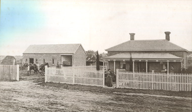
Photograph - 115 Jasper Road, Bentleigh, Allan / Grewer Estate, c. 1890's
115 Jasper Road, Bentleigh East was a market garden owned by James Allan. In 1880 the property was transferred to David Grewar (Gruar) who had married James' niece Mary Allan. In 1926 part of the land was subdivided and sold as residential blocks. The block with the house pictured remained in the family until 1969. The land now forms part of Our Lady of Sacred Heart College. The description of the land owned by David Kidd Grewer (also spelt Gruar) in 1885: Fourteen acres or thereabouts at the corner of Jasper Road and Patterson’s Road East Brighton being part of Crown Block of 5720 acres Parish of Moorabbin County of Bourke being land comprised in Certificate of Title Volume 1344 Folio 268692 on which is erected a 4 roomed brick house with 2 rooms of wood at the rear and stable and a 2 roomed weatherboard cottage valued as under: 14 acres of land less crops £629.0.0 4 roomed brick house £250.0.0 Other buildings £50.0.0 2 roomed weatherboard cottage £35.0.0 Early pioneer family of the City of Moorabbin.Black and White photo in picture framegrewar, market garden, moorabbin, bentleigh, jasper road, housing, pioneer, james allan, orchard -
 Orbost & District Historical Society
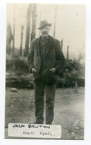
black and white photograph, before 1921
Jack Bruton selected land at Murrungowar and held the licence for the Murrungowar Hotel. He later became a butcher in Orbost. He was on the first Orbost Golf Club committee in 1906. .The golf club was established in 1906 it was originally formed as the Snowy River Golf Club and played on private land near the banks of the Snowy River just to the south of town.This is a pictorial record of Jack Bruton, one of the early settlers of Murrungowar, a former township east of Orbost.A black / white photograph of a man standing outside alone with his hands in his pocket. He has a moustache and has a pipe in his mouth. He is wearing a hat.on front - "Jack Bruton died 1921" on back - "Mr Jack Bruton, Murrungower Hotel"bruton-jack murrungowar-hotel orbost-golf-club -
 Greensborough Historical Society
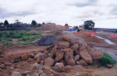
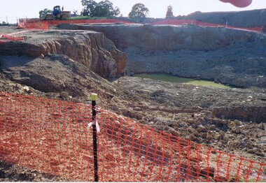
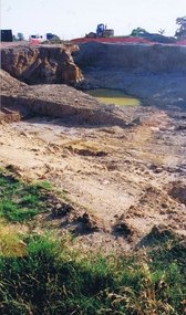
Photograph - Digital image, Frank Solomon, Development of pig farm to residential blocks, 1, 02/08/2009
A view of the redevelopment of the pig farm in Weidlich Road Greensborough, owned by Werner Hanusch. The land was used as a pig farm and quarry from 1954 and this photo shows early stages of the land being subdivided into the Evelyn Way estate. This project of fifty, one double storey, dwellings was commenced on 2/8/2009 and completed on 6/2/2011.An example of the changing land use in Greensborough, from farming to residential.Digital copy of colour photographwerner otto fritz hanusch, pig farm st helena, weidlich road greensborough, one evelyn way greensborough -
 Greensborough Historical Society
Photograph - Digital image, Frank Solomon, Development of pig farm to residential blocks, 2, 02/08/2009
A view of the redevelopment of the pig farm in Weidlich Road Greensborough, owned by Werner Hanusch. The land was used as a pig farm and quarry from 1954 and this photo shows early stages of the land being subdivided into the Evelyn Way estate. This project of fifty, one double storey, dwellings was commenced on 2/8/2009 and completed on 6/2/2011.An example of the changing land use in Greensborough, from farming to residential.Digital copy of colour photographwerner otto fritz hanusch, pig farm st helena, weidlich road greensborough, one evelyn way greensborough -
 Greensborough Historical Society
Photograph - Digital image, Frank Solomon, Development of pig farm to residential blocks, 3, 02/08/2009
A view of the redevelopment of the pig farm in Weidlich Road Greensborough, owned by Werner Hanusch. The land was used as a pig farm and quarry from 1954 and this photo shows early stages of the land being subdivided into the Evelyn Way estate. This project of fifty, one double storey, dwellings was commenced on 2/8/2009 and completed on 6/2/2011.An example of the changing land use in Greensborough, from farming to residential.Digital copy of colour photographwerner otto fritz hanusch, pig farm st helena, weidlich road greensborough, one evelyn way greensborough