Showing 3548 items
matching on the beach
-
 Victorian Interpretive Projects Inc.
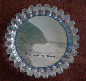
Image of souvenir ware, Apollo Bay
Apollo Bay is located between Wye River and Cape Otway on Victoria's scenic coastal route, the Great Ocean Road. In the 1840s the Henty brothers established a whaling station at Point Bunbury on the western end of the bay. The bay was named by Captain Loutit in 1845 when he sheltered his vessel, the Apollo during a storm. (http://en.wikipedia.org/wiki/Apollo_Bay)A coloured picture of a coastline attached to a glass butter plate. The coastline is Cape Patton, Apollo Bay, Victoria"Apollo Bay"apollo bay, beach, coast, souvenir -
 Victorian Interpretive Projects Inc.
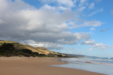
Photograph -Colour, Apollo Bay, Victoria, 2105, 25/01.2015
Apollo Bay is a coastal town in Victoria. A number of colour photographs of the coast at Apollo Bay, Victoria.apollo bay, coast, beach, sea, seaside, surf -
 National Vietnam Veterans Museum (NVVM)
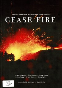
Book, Little, Ken, Cease Fire: Courage Under Fire. Vietnam And Other Conflicts, 2020
Cease Fire is a must read story about the lives of five men from Sydney's Northern Beaches who were involved in the Vietnam War, and another whose life was affected by the Second World War. The stories in Cease Fire are compelling and educate readers about the effects of war on human lives. It is ironic that the war did not cease for many returned soldiers - the firing never stopped.Six Vietnam Veterans' stories of their time in Vietnam.Cease Fire is a must read story about the lives of five men from Sydney's Northern Beaches who were involved in the Vietnam War, and another whose life was affected by the Second World War. The stories in Cease Fire are compelling and educate readers about the effects of war on human lives. It is ironic that the war did not cease for many returned soldiers - the firing never stopped. 1961 - 1975 -- veterans -- australia, 1961 - 1975 - veterans - australia - biography, vietnam war, 1961 - 1975, personal narratives - australian -
 National Vietnam Veterans Museum (NVVM)
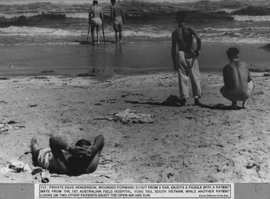
Photograph, Back Beach 2
A black and white photograph of Private Dave Henderson, wounded forward scout from 8 RAR, enjoys a paddle with a patient mate from the 1st Australian Field Hospital, Vung Tau, South Vietnam, while another patient looks on. Two other patients enjoy the open air and sun.photograph, pte dave henderson, 8 rar, 1st australian field hospital, vung tau, back beach, gibbons collection catalogue -
 National Vietnam Veterans Museum (NVVM)
Book, A 'duty clear before us': North Beach and the Sari Bair Range
world war, 1914-1918 - australia, gallipoli peninsula (turkey) - history, military -
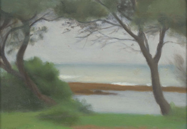 Benalla Art Gallery
Painting, Clarice BECKETT, Beach scene, Not dated
Born: Casterton, Victoria, Australia 1887; Died: 1935TonalismGift of an anonymous donor, 1978Seaside landscape with trees, grass and rocks. Old gold coloured timber frame.Recto: Signed “C Beckett” in brown paint l.l.c of composition; Not dated; Not titledseascape, landscape, trees, water, australian art -
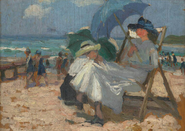 Benalla Art Gallery
Painting, Ethel CARRICK, Beach scene, Sydney (Manly Beach), c. 1910
Born: Uxbridge, Middlesex, England 1872; Active Australia from 1908; Died: Melbourne, Victoria, Australia 1952ImpressionismGift of Pamela Davies, 2005Seaside landscape with seated figure and figures on sand and in the water.Recto: Not signed; Not dated; Not titledbeachscape, figures, summer, sand, waves, umbrella, australian art -
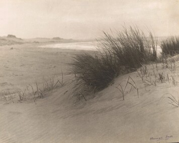 Horsham Regional Art Gallery
Photograph, Norman DECK, Beach at Thirroul, 1906
Purchased through the Horsham Art Gallery Trust Fund with the assistance of the Caltex-Victorian Government Art Fund, 1979 -
 St Kilda Historical Society
Photograph - Photo map, 28/01/1951
One of a series of photo-maps produced for the Department of Crown Lands and Survey (1857-1983). For correlation with a current map, and access to other historical photo maps of Victoria, see the Historic Photo-Maps Index published by the Department of Environment, Land, Water and Planning at https://services.land.vic.gov.au/DELWPmaps/historical-photomaps/Black and white aerial photograph1424-45 SECRET 534 Run 18 Lens 12" Melbourne Metropolitan 12150 28.1.51 M639albert park, st kilda junction, st kilda pier, catani gardens, st kilda, prahran, albert park lake, 1951, middle park, st kilda beach, windsor -
 St Kilda Historical Society
Photograph - Photo map, 17/01/1951
One of a series of photo-maps produced for the Department of Crown Lands and Survey (1857-1983). For correlation with a current map, and access to other historical photo maps of Victoria, see the Historic Photo-Maps Index published by the Department of Environment, Land, Water and Planning at https://services.land.vic.gov.au/DELWPmaps/historical-photomaps/Black and white aerial photograph1414-21 538 Run 19 Lens 12" Melbourne Metropolitan 12150 17.1.51 M586st kilda, st kilda botanical gardens, peanut farm, elwood, 1951, point ormond, elwood canal, st kilda beach -
 St Kilda Historical Society
Photograph - Photo map, 28/01/1951
One of a series of photo-maps produced for the Department of Crown Lands and Survey (1857-1983). For correlation with a current map, and access to other historical photo maps of Victoria, see the Historic Photo-Maps Index published by the Department of Environment, Land, Water and Planning at https://services.land.vic.gov.au/DELWPmaps/historical-photomaps/Black and white aerial photograph1424-118 534 Run 20 Lens 12" Melbourne Metropolitan 12150 18.1.51M639elwood, point ormond, elwood park, elsternwick park, elwood beach, 1951 -
 St Kilda Historical Society
Photograph - Photo map, 30/01/1960
One of a series of photo-maps produced for the Department of Crown Lands and Survey (1857-1983). For correlation with a current map, and access to other historical photo maps of Victoria, see the Historic Photo-Maps Index published by the Department of Environment, Land, Water and Planning at https://services.land.vic.gov.au/DELWPmaps/historical-photomaps/Black and white aerial photographVic 1092-36 Melbourne & Metropolitan Project Run 22 30.1.60 Lens 10" 8.200st kilda, st kilda pier, st kilda beach, catani gardens, 1960 -
 St Kilda Historical Society
Photograph - Photo map, 30/01/1960
One of a series of photo-maps produced for the Department of Crown Lands and Survey (1857-1983). For correlation with a current map, and access to other historical photo maps of Victoria, see the Historic Photo-Maps Index published by the Department of Environment, Land, Water and Planning at https://services.land.vic.gov.au/DELWPmaps/historical-photomaps/Black and white aerial photographVic 1092-38 Melbourne & Metropolitan Project Run 22 30.1.60 Lens 10" 8.200st kilda, st kilda beach, st kilda pier, catani gardens, 1960, st kilda botanical gardens, peanut farm -
 St Kilda Historical Society
Photograph - Photo map, 30/01/1960
One of a series of photo-maps produced for the Department of Crown Lands and Survey (1857-1983). For correlation with a current map, and access to other historical photo maps of Victoria, see the Historic Photo-Maps Index published by the Department of Environment, Land, Water and Planning at https://services.land.vic.gov.au/DELWPmaps/historical-photomaps/Black and white aerial photographVic 1091-1 Melbourne & Metropolitan Project Run 24East 30.1.60 Lens 10" 8.200elwood, elwood beach, elwood park, 1960 -
 St Kilda Historical Society
Photograph - Photo map, 30/01/1960
One of a series of photo-maps produced for the Department of Crown Lands and Survey (1857-1983). For correlation with a current map, and access to other historical photo maps of Victoria, see the Historic Photo-Maps Index published by the Department of Environment, Land, Water and Planning at https://services.land.vic.gov.au/DELWPmaps/historical-photomaps/Black and white aerial photographVic 1091-2 Melbourne & Metropolitan Project Run 24East 30.1.60 Lens 10" 8.200elwood, elwood park, elwood beach, elsternwick park, 1960 -
 St Kilda Historical Society
Photograph - Photo map, 14/12/1963
One of a series of photo-maps produced for the Department of Crown Lands and Survey (1857-1983). For correlation with a current map, and access to other historical photo maps of Victoria, see the Historic Photo-Maps Index published by the Department of Environment, Land, Water and Planning at https://services.land.vic.gov.au/DELWPmaps/historical-photomaps/Black and white aerial photographVic 1806 Melbourne 1964 Project Run 18 14.12.63 Lens 205 152.70 M/M 5.150 161elsternwick, elsternwick park, elwood, elwood canal, elwood beach, elwood park, 1963 -
 St Kilda Historical Society
Photograph - Photo map, 12/04/1966
One of a series of photo-maps produced for the Department of Crown Lands and Survey (1857-1983). For correlation with a current map, and access to other historical photo maps of Victoria, see the Historic Photo-Maps Index published by the Department of Environment, Land, Water and Planning at https://services.land.vic.gov.au/DELWPmaps/historical-photomaps/Black and white aerial photographVic 1933 Melbourne 1966 Project Run 12 12.4.66 Lens 122 151.75MM 9.800 152st kilda, st kilda pier, st kilda marina, albert park, fawkner park, windsor, south yarra, prahran, st kilda west, middle park, st kilda beach, 1966 -
 St Kilda Historical Society
Photograph - Photo map, 08/02/1966
One of a series of photo-maps produced for the Department of Crown Lands and Survey (1857-1983). For correlation with a current map, and access to other historical photo maps of Victoria, see the Historic Photo-Maps Index published by the Department of Environment, Land, Water and Planning at https://services.land.vic.gov.au/DELWPmaps/historical-photomaps/Black and white aerial photographVic 1916 Melbourne 1966 Project Run 13 E 8.2.66 Lens 122 151.75MM 9.800 113st kilda, st kilda marina, st kilda beach, point ormond, elwood, elwood beach, elwood park, 1966 -
 St Kilda Historical Society
Photograph - Photo map, 08/02/1966
One of a series of photo-maps produced for the Department of Crown Lands and Survey (1857-1983). For correlation with a current map, and access to other historical photo maps of Victoria, see the Historic Photo-Maps Index published by the Department of Environment, Land, Water and Planning at https://services.land.vic.gov.au/DELWPmaps/historical-photomaps/Black and white aerial photographVic 1916 Melbourne 1966 Project Run 13 E 8.2.66 Lens 122 151.75MM 9.800 111st kilda, balaclava, caulfield, caulfield north, st kilda east, elsternwick, elsterwick park, elwood park, elwood canal, elwood beach, ripponlea, 1966 -
 St Kilda Historical Society
Photograph - Photo map, 11/01/1968
One of a series of photo-maps produced for the Department of Crown Lands and Survey (1857-1983). For correlation with a current map, and access to other historical photo maps of Victoria, see the Historic Photo-Maps Index published by the Department of Environment, Land, Water and Planning at https://services.land.vic.gov.au/DELWPmaps/historical-photomaps/Black and white aerial photographVic 2132 State Aerial Survey Melbourne 1968 Proj. Run 27E 11.1.68 5100 ASL 69st kilda, albert park, st kilda east, st kilda beach, alma park, windsor, prahran, 1968 -
 St Kilda Historical Society
Photograph - Photo map, 11/01/1968
One of a series of photo-maps produced for the Department of Crown Lands and Survey (1857-1983). For correlation with a current map, and access to other historical photo maps of Victoria, see the Historic Photo-Maps Index published by the Department of Environment, Land, Water and Planning at https://services.land.vic.gov.au/DELWPmaps/historical-photomaps/Black and white aerial photographVic 2132 State Aerial Survey Melbourne 1968 Proj. Run 29E 11.1.68 5100 ASL 194elwood, elwood beach, elwood park, elsternwick park, ripponlea, elwood canal, balaclava, st kilda, 1968 -
 St Kilda Historical Society
Photograph - Photo map, 11/01/1968
One of a series of photo-maps produced for the Department of Crown Lands and Survey (1857-1983). For correlation with a current map, and access to other historical photo maps of Victoria, see the Historic Photo-Maps Index published by the Department of Environment, Land, Water and Planning at https://services.land.vic.gov.au/DELWPmaps/historical-photomaps/Black and white aerial photographVic 2132 State Aerial Survey Melbourne 1968 Proj. Run 27E 11.1.68 5100 ASLst kilda, st kilda west, st kilda pier, catani gardens, st kilda beach, albert park, 1968 -
 St Kilda Historical Society
Photograph - Photo map, 11/01/1968
One of a series of photo-maps produced for the Department of Crown Lands and Survey (1857-1983). For correlation with a current map, and access to other historical photo maps of Victoria, see the Historic Photo-Maps Index published by the Department of Environment, Land, Water and Planning at https://services.land.vic.gov.au/DELWPmaps/historical-photomaps/Black and white aerial photographVic 2132 State Aerial Survey Melbourne 1968 Proj. Run 29E 11.1.68 5100 ASL 196elwood, elwood park, elwood canal, elwood beach, st kilda marina, mc moran reserve, point ormond, 1968 -
 St Kilda Historical Society
Photograph - Photo map, Department of Crown Lands and Survey, 22/01/1970
One of a series of photo-maps produced for the Department of Crown Lands and Survey (1857-1983). For correlation with a current map, and access to other historical photo maps of Victoria, see the Historic Photo-Maps Index published by the Department of Environment, Land, Water and Planning at https://services.land.vic.gov.au/DELWPmaps/historical-photomaps/Black and white aerial photographVic 2358 Department of Crown Lands and Survey Victoria,.© Melbourne 1970 Project Run 43E 22.1.70 5,100 ASL 208elwood, elwood beach, point ormond, elwood park, elwood canal, mc moran reserve, 1970 -
 St Kilda Historical Society
Photograph - Photo map, Department of Crown Lands and Survey, 22/01/1970
One of a series of photo-maps produced for the Department of Crown Lands and Survey (1857-1983). For correlation with a current map, and access to other historical photo maps of Victoria, see the Historic Photo-Maps Index published by the Department of Environment, Land, Water and Planning at https://services.land.vic.gov.au/DELWPmaps/historical-photomaps/Black and white aerial photographCONTROLLED Vic 2358 Department of Crown Lands and Survey Victoria,.© Melbourne 1970 Project Run 41E 22.1.70 5,100 ASL 66st kilda, albert park, st kilda west, catani gardens, st kilda botanical gardens, st kilda pier, st kilda beach, 1970 -
 St Kilda Historical Society
Photograph - Photo map, Department of Crown Lands and Survey, 22/01/1970
One of a series of photo-maps produced for the Department of Crown Lands and Survey (1857-1983). For correlation with a current map, and access to other historical photo maps of Victoria, see the Historic Photo-Maps Index published by the Department of Environment, Land, Water and Planning at https://services.land.vic.gov.au/DELWPmaps/historical-photomaps/Black and white aerial photographVic 2358 Department of Crown Lands and Survey Victoria,.© Melbourne 1970 Project Run 42E 22.1.70 5,100 ASL 75st kilda, st kilda beach, st kilda marina, point ormond, st kilda pier, 1970 -
 St Kilda Historical Society
Photograph - Photo map, 14/12/1963
One of a series of photo-maps produced for the Department of Crown Lands and Survey (1857-1983). For correlation with a current map, and access to other historical photo maps of Victoria, see the Historic Photo-Maps Index published by the Department of Environment, Land, Water and Planning at https://services.land.vic.gov.au/DELWPmaps/historical-photomaps/Black and white aerial photographVic 1807 Melbourne 1963 Project Run 16 14.12.1963 Lens 205 152.70 M/M 5.150 177st kilda, st kilda pier, catani gardens, middle park, albert park, st kilda west, st kilda beach, 1963 -
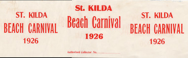 St Kilda Historical Society
Ephemera - Banner, St Kilda Beach Carnival 1926, 1926
Collector's banner, with provision for details of authorised collector numberWhite coloured paper printed in redst kilda beach, st kilda carnivals -
 St Kilda Historical Society
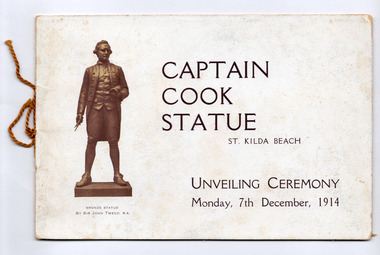
Ephemera - Special event program, Osboldstone & Co. Pty. Ltd, Captain Cook Statue St Kilda Beach Unveiling Ceremony Monday, 17th December, 1914, 1914
The booklet was produced for the unveiling of the Captain Cook Statue on 7 December 1914 at the St. Kilda Foreshore. It contains details of Cook's life, the statue and the donor, Andrew Stenhouse, as well as of its unveiling. The statue was unveiled by the Governor of Victoria, Sir Arthur Stanley, watched on by Commonwealth and State dignitaries and hundreds of St Kilda residents. Sixteen page booklet of white paper printed in brown with cardboard cover of similar colours. Secured by brown cotton cord..st kilda, catani gardens, john tweed, andrew stenhouse, captain cook statue, statue, captain cook -
 St Kilda Historical Society
Ephemera - Stamps, Don't Forget St Kilda Beach Carnival Sat. Feb. 27 to Sat. Mar. 6, 1926
The stamps advertise a 5-day festival in 1926 to raise funds for the Bush Fire Relief Fund, Soldiers' Memorial Hall, St Vincent's Hospital and the Catani Memorial (St Kilda cenotaph).Series of five identical stamps, printed in red and pink on a sheet of perforated white paper, discoloured with age, and backed with gum. st kilda carnivals, st kilda beach, wwi fund-raising