Showing 10534 items
matching lander
-
 Orbost & District Historical Society
bill file, early 20th century
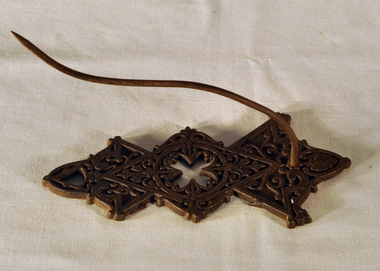
Ossie Green was a retired primary school principal living in Marlo. He wrote many historical books including Marlo The Township; The Plains The Cape. Mrs Green was a McKeown from Marlo. McKeowns had large land holdings around Marlo for farming.This item is an example of a commonly used item in the late 19th -early 20th century. It reflects a time when accounts were made of paper and retained as records by households. Black cast iron billfile. Ornate design with large spike.bill-file ornaments-metal green-ossie mckeown -
 Orbost & District Historical Society
advertisement, before 1933
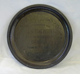
John Tomlinson was the eldest son of Arthur James and Jessie Tomlinson who selected land at Tabbara in 1887. He worked in Temple's , the Herbert's store and for the Butter Factory until beginning his own business in 1906. He remained in business until 1933.A round metal tray with decorated edge. It is an engraved advertisement for J.S. Tomlinson.advertisement tomlinson commerce-orbost -
 Federation University Historical Collection
Booklet, Robert Clark Horticultural Centre: Ballarat Botanical Gardens, c1993
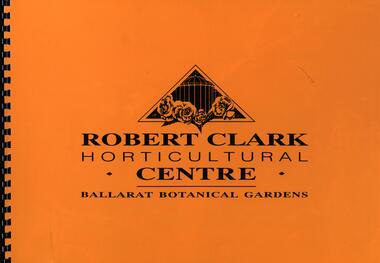
"The 250 acres of land to the west of Yuilles Swamp (Lake Wendouree) was permanently granted to The Corporation of the City of Ballaarat by the State Government on the 23rd December 1857 for the purposes of a 'Botanical Garden for the recreation, education and enjoyment of the community." The Robert Clark Horticultural Centre was opened in 1995.Large format spiral bound booklet with yellow cover. Bordered pages with writing or coloured photographsyuilles swamp, lake wendouree, corporation of the city of ballaarat, botanical gardens, recreation, education, horticulture, robert clark, ballarat botanical gardens, robert clark centre, robert clark horticultural centre -
 Hume City Civic Collection
Photograph, Late 1980's
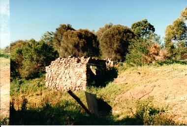
The Millbrook ruins are on a property which was created by John Pascoe Fawkner's Victoria Co-operative Freehold Land Investment Society. The aims of the company were to provide smallholdings to poorer settlers who wanted to farm. The ruins are now part of the Organ Pipes Park.A coloured photograph of stone ruins built on a hillside with sheoaks and other vegetation behind it. There is a doorway at the end of the small building.fawkner, john pascoe, millbrook ruin, jacksons creek, organ pipes park, victorian co-operative freehold land investment society, george evans collection -
 Hume City Civic Collection
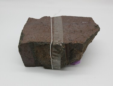
Brick
This half broken brick comes from the brickworks owned by Robinson Allison. The brickworks operated approximately between the years 1859 - 1883 on crown land near Watson's Road, Sunbury. This brick may have come from a ruin near the Organ Pipes.Approximately half a brick brown/red colour smooth at one end uneven sides.on top - "ALLISONS'1860s, 1880s, sunbury, brick, shire of bulla, dunn, trevor, margaret, allison, robinson, george evans collection -
 Kew Historical Society Inc
Plan - Subdivision Plan, Windella-Darnley Subdivision, Studley Park, 1920s
Subdivision plans are historically important documents used as evidence of the growth of suburbs in Australia. They frequently provide information about when the land was sold on which a built structure was subsequently constructed as well as evidence relating to surveyors and real estate and financial agents. The numerous subdivision plans in the Kew Historical Society's collection represent working documents, ranging from the initial sketches made in planning a subdivision to printed plans on which auctioneers or agents listed the prices for which individual lots were sold. In a number of cases, the reverse of a subdivision plan in the collection includes a photograph of a house that was also for sale by the agent. These photographs provide significant heritage information relating house design and decoration, fencing and household gardens.Version 2 of two subdivision plans (the earlier is 2016.0305.1) for the section of Studley Park Road near the Junction on the south side. Named in the subdivision are the mansions of Darley and Windella (now demolished). Before the subdivision of Darley and Windella, both houses fronted Studley Park Road. Both houses appear to be advertised as lots in the subdivision. Bisecting the subdivision is a street, Antrim Avenue that was never constructed. A street, which was subsequently constructed in this vicinity, was Merrion Place, which now runs between Studley Park Road and Highfield Grove. There are 13 proposed lots in this subdivision in contrast to the earlier plan. This resulted from larger lots being proposed for Studley Park Road.subdivision plans - kew, studley park, windella, darnley, antrim avenue -- kew (vic.), studley park road -- kew (vic.), merrion place -- kew (vic.), merrion grove -- kew (vic.), highbury grove -- kew (vic.) -
 Expression Australia
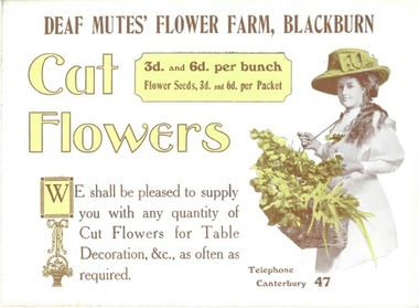
Advertising Card, Cut Flowers - Deaf Mutes' Flower Farm, Blackburn
The Australian Deaf and Dumb Society of Victoria purchased and developed land at Blackburn Lake as a flower farm, the idea being to provide light occupation for the deaf and dumb unable to follow other regular employment, A home for aged and infirm deaf was also erected on the property.A rare example of advertising produced by the Adult Deaf and Dumb Society of Victoria for its Flower Farm at BlackburnSize 15.5cmHx21cmWlake park, blackburn, flower farm, deaf -
 Expression Australia
Advertising Booklet, Lake Park Blackburn - The Idael Place for Pic-Nics
The Australian Deaf and Dumb Society of Victoria purchased and developed land at Blackburn Lake as a flower farm, the idea being to provide light occupation for the deaf and dumb unable to follow other regular employment, A home for aged and infirm deaf was also erected on the property.A rare booklet advertising Lake Park Blackburn as an ideal public picnic spot.Size 12cmHx15cmW; 12 pages -
 City of Greater Geelong
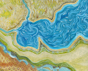
Painting - Acrylic on Canvas, Dr Jenny Murray-Jones, Corio, 2019
This work is all about Country for Wadawurrung people, the lay of the land, food crops and the abundant recourses which sustains the Wadawurrung people. Again I have used traditional patterns and made reference to Wallaby Grass and Murnong staple foods for Wadawurrung people.Painting of river and grassland from above. Green, blue and brown used.On back left bottom corner - J.Murray.Jones 2019 'Corio'corio, wadawurrung, murnong -
 Phillip Island and District Historical Society Inc.
Photographs, 1926
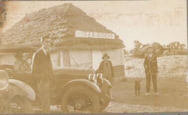
Part of a collection of photographs out of an old photo album with multiple photos on each page. Donated by Margaret Webster. Margaret's parents were Sir Charles & Lady McGrath who lived near the RSL in Ventnor Road, Cowes.286-18 - Sepia photograph of The Tea Room at Shelly Beach, Phillip Island or San Remo?. Two men, a lady and dog beside two cars. One car has a woman inside. 286-19 - Sepia photograph of a group of 13 people in coastal scrub land at Shelly Beach. 286-20 - Sepia photograph of a group of 13 people in coastal scrub land at Shelly Beach. 286-21 - Sepia photograph of a group of people having a picnic in front of the San Remo Hotel. 286-22 - Sepia photograph of 3 people at The Nobbies, Phillip Island. 286-23 - Sepia photograph of rough seas at The Nobbies, Phillip Island. 286-24 - Sepia photograph of a man with a young penguin possibly at Slummerlands Phillip Island. 286-25 - Sepia photograph of breakers at The Nobbies, Phillip Island. 286-26 - Sepia photograph of The Continental Guesthouse with guests on the verandah. 286-27 - Sepia photograph of an unmade road with scrub vegetation on the sides. 286-28 - Sepia photograph of Cowes foreshore with the Jetty in the background. 286-29 - Sepia photograph of the Cowes Jetty with people arriving off a ferry. 286-30 - Sepia photograph of Cowes foreshore with the Jetty in the background and a ferry.286-18 - "The Teahouse - Shelly Beach" 286-19 - "A Confidential Chat - Shelly Beach" 286-20 - "The Wanders - San Remo" 286-21 - "Lunch at San Remo" 286-22 - "The Nobbies - P.I." 286-23 - "Rough Seas - The Nobbies" 286-24 - "A Young Penguin" 286-25 - "Breakers - The Nobbies" 286-26 - "The Contin - Cowes" 286-27 - "The Road to the Back Beach" 286-28, 29 & 30 - "Beach and Jetty at Cowes"the nobbies phillip island, young penguins, wildlife - penguins, tea house behind shelly beach, shelly beach, san remo hotel, the continental guesthouse, the continental hotel, cowes jetty, margaret webster -
 Bendigo Historical Society Inc.
Document - MCCOLL, RANKIN AND STANISTREET COLLECTION: INDENTURE BETWEEN KING EDWARD VIII AND MONUMENT HILL CONSOLIDATED MINE, 2/09/1936
Indenture document number 10878, Vol 317 Folio 35044. Foolscap 4 pages including a map, dated 2nd September, 1936, between King Edward VIII (Crown land) and Monument Hill Consolidated (Bendigo) No Liability 'carrying on operations in the Parish of Sandhurst, to occupy and use the land demised as a site for machinery buildings and offices to be used in connexion with 'mining purposes' ' Document signed by Right Hon William Charles Arcedeckne, (Baron Huntingfield) and J. Stanistreet, Manager, affixed with the Common Seal of Monument Hill Consolidated (Bendigo) No Liability. Map drawn on dark buff paper, and fixed to document. Map shows lease 10878 in the Mining District of Bendigo, Parish of Sandhurst, County of Bendigo. N.Area 2.2.24 ( 2 acres, 2 roods, 24 perches ) Lease site on Rowan Street, bordered by Ophir Street. Coloured in purple on plan with small red area. On bottom: ' Note Red Areas Excised. Scale 4 chains to 1 inch, M.M. Var. 8 degrees 32' E. On lease site, New Chum Gully marked, W.B. House, and Permanent Occy. marked on red area. On last page ownership of lease details from 1937 to 1942.bendigo, mining, monument hill consolidated, common seal of monument hill consolidated, nell gwynne mine, south nell gwynne gold mining company, bendigo mine, ophir street, rowan street, mackenzie street.indenture vol 317 fol. 35044. j stanistreet. -
 Bendigo Historical Society Inc.
Document - CONNELLY, TATCHELL, DUNLOP COLLECTION: LEGAL DOCUMENTS, 1919 & 1920
Documents. Various legal documents. 1 - 1920 - Sloan John Esq (Bul-A-Bul) Re costs owed Federal Land Tax. 2 - 1920 - Scholten G J. deceased (::Bendigo) RE costs Income Tax. 3 - 1919 - Connell J D & Bailey A D (clo Mr F Lapsley Bendigo) re costs Bogie. 4 - 1920 - Chambers John Jr. (Leichardt) re costs Chambers. 5 - 1920 - Cowling W (Bendigo) re costs Burke. 6 - 1919 - 1920 - Bailey A W Farmer (South Calivil) re costs Mathoura Land and Will. 7 - 1919 - 1920 - Bell Albert J (Leichardt) re costs A D A insurance and Will. 8 - 1919 - Bell S (Chemist Inglewood) re costs Libel. 9 - 1920 - Bagnell L Sr (Mologa) re costs Income Tax Returns. 10 - 1920 Bell James & Co. (:Melbourne) re costs Hogan. 11 - 1919 Butcher W H (Raywood) re costs Shadbolt, McNamara. 12 - 1920 - Bell John (Farmer Leichardt) re costs you from Cocks. Additional names:- McNamara, Bell John, Cocks.cottage, miners, connelly, tatchell & dunlop, sloan john, scholten g j, connell j d, bailey a d, lapsley mr f, bogie, chambers john jr, cowling w, burke, bailey a w, bell albert j, a d a insurance, bell a, bagnell l sr, bell james & co, hogan, butcher w h, shadbolt -
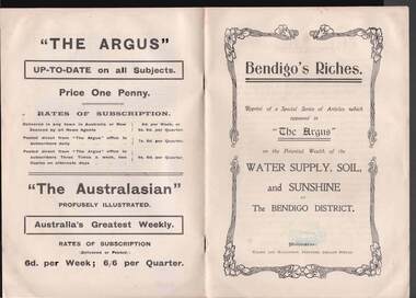 Bendigo Historical Society Inc.
Book - BOOK: BENDIGO'S RICHES
Small booklet titled 'Bendigo's Riches'. Reprint of a Special Series of Articles which appeared in 'The Argus' on the Potential Wealth of the Water Supply, Soil, and Sunshine of The Bendigo District. Printed by Wilson and Mackinnon, Printers, Collins Street. Booklet mentions the potential wealth of Bendigo's Water, Soil and Sunshine; Orchards, Dairying, Tomato Growing, Fruitgrowing, Land, and Water Supply. Also discussed are Antiquated Mining Regulations, City Trust suggested, and its Advantages, Opportunities, 'The Argus' suggestions endorsed, Mine-owner's Opinion, The Mayor of Bendigo's Opinion, Statement by Strathfieldsaye Shire Secretary, Locked-up Area Useless for Timber, Shire Appeals for Unlocking the Land, 'The Argus' Thanked, Bendigo Chamber of Commerce, Bendigo City Council and Preserving Factory at Bendigo. Photos include: Irrigated pastures, rye-grass and clovers on Mr James Cumming's Farm; Irrigating Tomatoes on Mr Elliot Borley's Farm, White Hills; Junction of Huntly and White Hills Irrigation Channels; Packing Tomatoes at Mr B. Puig Y. Ventura's Garden, White Hills; and Tomato Patch on the Holding of Mr T. L. Sweeny, Jun. Back of the booklet has subscription rates and price of The Argus. Missing 8/07/2021place, land, agricultural, book - bendigo's riches, the argus, wilson and mackinnon, councillor carolin, james cumming, dairying, mr elwood mead, tomato growing, mr b puig y ventura, mr elliot borley, fruitgrowers, bendigo fruitgrowers' co-operative society, mr w a hamilton ex-mla, upper coliban, coliban system, antiquated mining regulations, lands department, chaffey bros, mr g h crawford, mine-owners' association, councillor andrew, mr baillieu, miners' association, agricultural society, sir thomas bent, strathfieldsaye shire, mr r b brennan, mr t l sweeny jun, bendigo sewerage farm, councillor osborne, councillor lowndes, councillor t r long, bendigo chamber of commerce, bendigo city council, councillor andrew, councillor h a ross, councillor wilkie, h m leggo and co -
 Kew Historical Society Inc
Plan, Melbourne & Metropolitan Board of Works : Contour Plan of Melbourne & Suburbs : Melbourne Sewage, 1894
The Melbourne and Metropolitan Board of Works (MMBW) plans were produced from the 1890s to the 1950s. They were crucial to the design and development of Melbourne's sewerage and drainage system. This plan forms part of a large group of MMBW plans and maps that was donated to the Society by the Mr Poulter, City Engineer of the City of Kew in 1989. Within this collection, thirty-five hand-coloured plans, backed with linen, are of statewide significance as they include annotations that provide details of construction materials used in buildings in the first decade of the 20th century as well as additional information about land ownership and usage. The copies in the Public Record Office Victoria and the State Library of Victoria are monochrome versions which do not denote building materials so that the maps in this collection are invaluable and unique tools for researchers and heritage consultants. A number of the plans are not held in the collection of the State Library of Victoria so they have the additional attribute of rarity.Digital copy of an original MMBW plan. This contour plan shows the area identified by the MMBW for purposes of drainage and sewerage in 1894. The suburbs represented extend from Williamstown in the west to Bulleen in the east, and from Preston in the north, south to Sandringham. Suburbs are outlined in coloured ink. Red lines indicate main and branch sewers in existence at the beginning of 1894 in central and inner Melbourne. These extended as far as Williamstown and Brighton, but not yet as far as Kew, where sewering did not commence until 1901. Contour lines show the topography, which was important for indicating the fall of the land for the laying of sewers and drainage channels. Kew appears to be fairly undeveloped at this date except for railway lines and stations (the Kew and Outer Circle lines), main roads, the Kew Lunatic Asylum Reserve and Studley Park. However, the contour plan does not accurately represent the density of settlement, nor the large number of houses, which were being built in Kew and other suburbs from the 1850s to the land boom of the late 1880’s and early 1890’s. This plan is part of a large and historically significant group of MMBW plans and maps that was donated to the Society by the Mr Poulter, City Engineer of the City of Kew in 1989.mmbw contour plan of melbourne and suburbs, melbourne and metropolitan board of works, melbourne sewage, cartography -
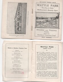 Melbourne Tram Museum
Ephemera - Timetable, Hawthorn Tramways Trust (HTT), "Directory and Tramway Guide issued by the Hawthorn Tramways Trust", 1918
Booklet - 38 pages, printed on off white page, centre stapled, titled "Directory and Tramway Guide issued by the Hawthorn Tramways Trust", specifically advertising Wattle Park and showing Princes Bridge and the Yarra on the front cover and a photo of Hawthorn depot on the rear cover. Gives details of Wattle Park, its opening, many photos, members of the Trust, Engineer and Manager and Acting Secretary, Stopping points for the round and fares to Wattle Park, section fares, maps of the tram routes and connections with other tramways and railway stations. Has timetables for Burnley and other major points, special and emergency services, the coloured lights used on the trams, and a map for land sales at Riversdale Heights estate. Advertisements for Mutual stores, Melbourne Electric Supply Co., Moule, Hamilton and Kindle for the sale of land at Riversdale Heights and a map showing the estate location. Both copies have alterations or corrections to the route signage letters - marked in red - from the Minutes of the HTT Board meetings, the Trust were not happy with the finished product and was reluctant to pay for them - see Minutes of Meeting No. 99 of 5-7-1918. Two copies held - one with red marks on the front cover.trams, tramways, htt, wattle park, princes bridge, hawthorn depot, timetables, mesco, real estate -
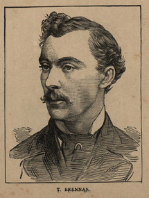 Ballarat and District Irish Association
Image, T. Brennan, c1864, 1864
Following the founding meeting of the Mayo Tenants Defence Association in Castlebar, County Mayo on 26 October 1878 the demand for The Land of Ireland for the people of Ireland was reported in the Connaught Telegraph 2 November 1878. The first of many "monster meetings" of tenant farmers was held in Irishtown near Claremorris on 20 April 1879, with an estimated turnout of 15,000 to 20,000 people. This meeting was addressed by James Daly (who presided), John O'Connor Power, John Ferguson, Thomas Brennan, and J. J. Louden. The Connaught Telegraph's report of the meeting in its edition of 26 April 1879 began: Since the days of O'Connell a larger public demonstration has not been witnessed than that of Sunday last. About 1 o'clock the monster procession started from Claremorris, headed by several thousand men on foot – the men of each district wearing a laural leaf or green ribbon in hat or coat to distinguish the several contingents. At 11 o'clock a monster contingent of tenant-farmers on horseback drew up in front of Hughes's hotel, showing discipline and order that a cavalry regiment might feel proud of. They were led on in sections, each having a marshal who kept his troops well in hand. Messrs. P.W. Nally, J.W. Nally, H. French, and M. Griffin, wearing green and gold sashes, led on their different sections, who rode two deep, occupying, at least, over an Irish mile of the road. Next followed a train of carriages, brakes, cares, etc. led on by Mr. Martin Hughes, the spirited hotel proprietor, driving a pair of rare black ponies to a phæton, taking Messrs. J.J. Louden and J. Daly. Next came Messrs. O'Connor, J. Ferguson, and Thomas Brennan in a covered carriage, followed by at least 500 vehicles from the neighbouring towns. On passing through Ballindine the sight was truly imposing, the endless train directing its course to Irishtown – a neat little hamlet on the boundaries of Mayo, Roscommon, and Galway. Evolving out of this a number of local land league organisations were set up to work against the excessive rents being demanded by landlords all over Ireland, but especially in Mayo and surrounding counties. From 1874 agricultural prices in Europe had dropped, followed by some bad harvests due to wet weather during the Long Depression. The effect by 1878 was that many Irish farmers were unable to pay the rents that they had agreed, particularly in the poorer and wetter parts of Connacht. The localised 1879 Famine added to the misery. Unlike other parts of Europe the Irish land tenure system was inflexible in times of hardship. (Wikipedia) The Irish National Land League was founded at the Imperial Hotel in Castlebar, the County town of Mayo, on 21 October 1879. At that meeting Charles Stewart Parnell was elected president of the league. Andrew Kettle, Michael Davitt, and Thomas Brennan were appointed as honorary secretaries. This united practically all the different strands of land agitation and tenant rights movements under a single organisation. Michael Davitt Founder of the Land League The two aims of the Land League, as stated in the resolutions adopted in the meeting, were: ...first, to bring out a reduction of rack-rents; second, to facilitate the obtaining of the ownership of the soil by the occupiers. That the object of the League can be best attained by promoting organisation among the tenant-farmers; by defending those who may be threatened with eviction for refusing to pay unjust rents; by facilitating the working of the Bright clauses of the Irish Land Act during the winter; and by obtaining such reforms in the laws relating to land as will enable every tenant to become owner of his holding by paying a fair rent for a limited number of years. (Wikipedia)Image of a man with a moustache. He is T. Brennan.ballarat irish, brennan, thomas brennan, irish land act, rent -
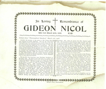 Warrnambool and District Historical Society Inc.
Document - Obituary Gideon Nicol, 2014
Gideon Nicol (1836-1908) was a seaman who came to Warrnambool in 1858. In 1865 he selected land at Mount Warrnambool. He was one of the founders of the Farnham Cheese and Butter Factory and the Garvoc Cheese and Butter Factory and was a Warrnambool Shire Councillor from 1879 to 1906. This scan will be useful to include in the Gideon Nicol fileThis is an A4 sheet of paper (scan). The obituary is printed in black and white with an ornate border with some discoloration on the outer edges.In Loving Remembrance of Gideon Nicol who died March 20th 1908, R.I.P. (an extract from the Warrnambool Standard follows)gideon nicol, warrnambool, gideon nicol obituary -
 Eltham District Historical Society Inc
Document - Folder, McMahon, Andrew
An interview with Andrew McMahon, who was completing his Ph.D. on fire ecology, describing past major fires and fire programs. Contents Newspaper article: "Land of fire", Diamond Valley News, 12 April, 1983, Andrew McMahon was completing a Ph.D. on fire ecology. Newspaper clippings, A4 photocopies, etc -
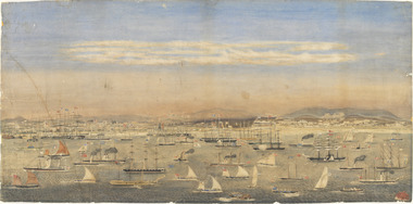 Mission to Seafarers Victoria
Print - Reproduction, Wilbraham Frederick Evelyn Liardet, View of the North Shore, Port of Melbourne, 1862
Liardet, W. F. E. (Wilbraham Frederick Evelyn), 1799-1878 depicts the busy port of Melbourne showing many types of ships and the Bethel Church built in 1860 on the Custom House land. The church replaced the Bethel ship which sank in February 1860.This watercolour along with the Francois Cogne print from 1863, "Sandridge from Hobson's Bay, and the engraving "A Bird's-eye View Of Melbourne From Sandridge" dating from 1882, is a rare depiction fo the Bethel church. In 1887, the church was demolished to erect the building still standing on the corner of Nott Street and Beach Road.wilbraham liardet, sandridge, port, ships, port melbourne, hobsons bay, bethel church, reverend kerr johnston, 1812-1887, missions to seamen, 1862, customs house -
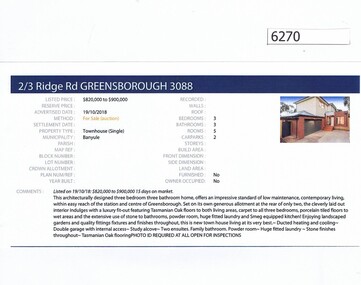 Greensborough Historical Society
Advertising Leaflet, Barry Plant Greensborough, 2/3 Ridge Road Greensborough, 19/10/2018
Real estate advertisement for 2/3 Ridge Road Greensborough, a 3 bedroom townhouse. This house was sold on 14/12/2018 for $850,000. Previous sales: January 2017 for $800,000. 3 Ridge Road (vacant land) was sold 19/05/2012 for $390,000.Real estate advertisement black text and colour photographridge road greensborough -
![Photograph - Digital Image, Johannes Adem Bosch [John Adam Bush], 1910c](/media/collectors/4f729f5697f83e03086015b8/items/5441c12a2162f10c081edebc/item-media/5441c15c2162f10c081ee01a/item-fit-380x285.jpg) Greensborough Historical Society
Greensborough Historical SocietyPhotograph - Digital Image, Johannes Adem Bosch [John Adam Bush], 1910c
Photograph of Johannes Bosch cropped from larger photograph. Johannes Bosch and family migrated from Southern Germany to Greensborough district c1889. They farmed along the Plenty River having purchased land from Flintoff. They later changed their surname from Bosch to Bush.Digital copy cropped from black and white photograph.johannes bosch, john adam bush, bosch family, bush family -
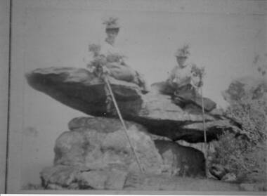 Halls Gap & Grampians Historical Society
Photograph - Sepia
The name " Balmain " has been attributed to the photo, James Balmain and his wife, Amy Sophia [D'Alton} purchased a vacant school cottage from the area and moved it to their land and called it Bellfield. Amy died at age 37, James returned to Scotland with their 3 children.Photo shows 2 women sitting on a rock formation, both are wearing hats adorned with flowers and appear to be wearing long skirts and high buttoned blouses. They are both holding sticks which seem to be decorated with flowers,recreation, bush-walking -
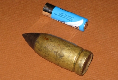 Friends of the Cerberus Inc
Nordenfelt 1 inch Projectile
One inch Nordenfelt machine guns were used on board vessels of the Victorian Navy to combat the torpedo boats. One inch, as opposed to the .45 inch, Nordenfelt guns used by the Land Forces could penetrate the boilers of torpedo boats and thereby stop them.none -
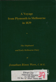 Eltham District Historical Society Inc
Book, A voyage from Plymouth to Melbourne in 1839 : the shipboard and early Melbourne diary of Jonathan Binns Were, 1964
J B Were was associated with Henry Dendy. Were Street, Montmorency possibly named for Were. "Were's were importers, exporters, and agents for shipping, land, cattle, sheep and wool. In 1851 they became brokers and buyers of gold, and in 1853 began to deal in shares." - ADB Hardback, no dust jacket; xv, 309 p. : ill., facsim., geneal. tables (folded), maps, ports. ; 20 cm.ISBN 0646002287ship voyage, early settlers, plymouth england, melbourne -
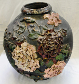 Orbost & District Historical Society
ginger jar, Pre 1893 floods in Orbost
In the early days of Orbost many Chinese were engaged in land clearing or had arrived when gold was discovered in East Gippsland in the 1840's. They lived in camps along the Marlo Road and houses were usually built on stilts. They left after the 1893 floods.This object has aesthetic appeal. It is an object which belonged to the very early settlement days of Orbost.Huge, ornate Chinese ginger jar. Four raised hand- painted pink roses on front. Jar itself is matt black. Looks more like a vase than a ginger jar. Ceramic.Some Chinese writing to left hand side of roses.ceramics, ginger jar, container - domestic, vase -
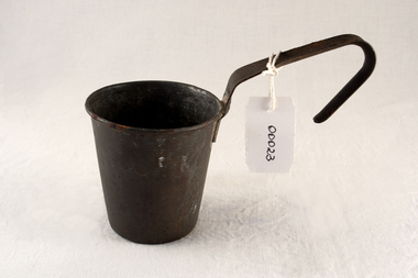 City of Moorabbin Historical Society (Operating the Box Cottage Museum)
Functional object - Kitchen equipment, water-dipper, c1920
Early settlers could only obtain clean water by sinking a well on their land. A pump was built to draw water for use by the family and this tin dipper would have been used for drinking water. The Lachlan Mackinnon family were early settlers in Moorabbin ShireEarly settlers had to sink wells on their land and build water pumps in order to obtain water. This tin dipper would have been used for drinking at the water pump . In 1846 Lachlan and Charles Mackinnon bought 117 acres of land in the 'Dendy's Special Survey' from J.B.Were This area is now known as the suburb of 'McKinnon' and may have been named after them.A tin water-dipper for obtaining drinking water from water pumpmoorabbin, wells, water supply, pioneers, ormond, bentleigh, mckinnon, market gardeners, early settlers, kitchen equipment, water pumps, mackinnon jessie, mackinnon donald, mackinnon lachlan, mackinnon charles, mackinnon daniel -
 City of Moorabbin Historical Society (Operating the Box Cottage Museum)
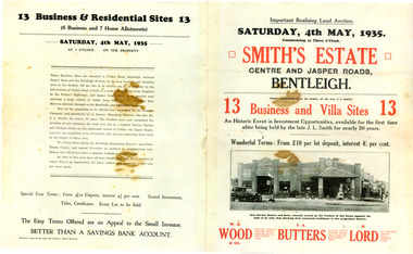
Flyer - Smith Estate, Bentleigh, 1935
This Land was owned by one the pioneers of Bentleigh Mr John Logan Smith (1860-1932), who owned J. L. Smith Hay & Grain Store, on the corner of Jasper and Centre Road, Bentleigh. The family sold the property after Mr Smith passed away.Example of the progress of the Municipality of MoorabbinAdvertising flyer for auction of real estate sales - plan of building blocks for sale - PhotocopySmith's Estate, Bentleigh 13 Home Sites and 13 Business Sites Auction Saturday 4 may 1935 - W. H.Wood, T. A. Butters, H. Lordjohn logan smith, centre road, jasper road, bentleigh, aution, real estate -
 City of Moorabbin Historical Society (Operating the Box Cottage Museum)
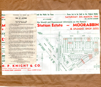
Flyer - Moorabbin Electric Station Estate, Moorabbin, 1941
The train line from the city to Frankston was electrified in 1922 which intensified the sale in the municipality of Moorabbin, particularly land which was in the vicinity of the railway stations. Moorabbin Electric Station Estate Sale of unsold and repossessed Allotments, the original sale was on Saturday 30 May 1925.Example of the progress of the Municipality of MoorabbinAdvertising flyer for auction of real estate sales - plan of building blocks for saleMoorabbin Electric Station Estate, Moorabbin. Auction Saturday 8 March 1941 - 9 villa units 4 shop sitessouth road, station street, taylor street, healey street, jasper street (now redholme street), central avenue, moorabbin, real estate -
 Victorian Interpretive Projects Inc.
Photograph - Colour, Clare Gervasoni, Drystone wall at White Flat, Ballarat, 07/10/2012
White Flat was an early gold diggings. As early as 1856 the White Flat Drainage and Mining Co. constructed water races, drained the swampy land, and changed the course of the Yarrowee Creek. This may be remnants of that work. See http://bih.ballarat.edu.au/index.php/White_Flat_Drainage_and_Mining_Co.#cite_note-0 Five colour digital imaged of a bluestone drystone wall at White Flat, Ballarat. The drystone wall is on the steep embankment between Hickman Street and Armstrong Street South. ballarat, white flat, white flat sports ground, hickman street, south street, armstong street, oval, cricket, football, white flat drainage, yarrowee creek drystone, bluestone -
Clunes Museum
Certificate, SWAINSON FAMILY, STATEMENT OF RECEIPTS AND EXPENDITURE
CERTIFICATE OF ESTATE FROM THE SWAINSON FAMILY HOME IN HILL STREET, CLUNES. THAT BEING SALE OF ASSET/S, LAND AND DWELLING, BEING ALLOTMENT 11, SECTION 6, TOWNSHIP OF CLUNES, PARISH OF CLUNES, COUNTY OF TALBOT. SOLD TO MRS. C.K. BUCHANAN. 1918-1919PHOTOCOPIES OF: .1 THE BALLARAT TRUSTEES EXECUTORS & AGENCY COMPANY LIMITED. STATEMENT OF RECEIPTS & EXPENDITURE FOR AND ON A/C OF ESTATE OF JOHN SWAINSON DECEASED DATED 23/9/1919 .2 & .3 PHOTOCOPIES OF THE BALLARAT TRUSTEES EXECUTORS & AGENCY COMPANY LIMITED. ESTATE OF JOHN SWAINSON DECEASED DATED 23/9/1919 .4 COVER LETTER FROM THE BALLARAT TRUSTEES EXECUTORS & AGENCY COMPANY LIMITED TO MRS. L.E. SWAINSON WIDOW OF JOHN SWAINSON DATED 17/10/1918 CHEQUE IN THE AMOUNT OF 93 POUNDS, 19 SHILLINGS AND ZERO PENCE IN LIEU OF THE SIGNED RELEASE.NILlocal history, certificates, swainson family, mrs. c k buchanan