Showing 27535 items
matching yarra-river
-
 Federation University Historical Collection
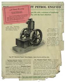
Document, Ronaldson and Tippett Petrol Engines, 1934, 18/04/1932
Share Scrip for R.B. Squire's Leigh River Tunnel Syndicate. squire, r.b. squire, ronaldson and tippett, ronaldson bros & tippett pty ltd., george clark -
 Bendigo Historical Society Inc.
Photograph - PHOTOGRAPH: BLACK AND WHITE MALE
photograph - black and white - male standing on rock in river - 'Adam '.photograph, person, male -
 Bendigo Historical Society Inc.
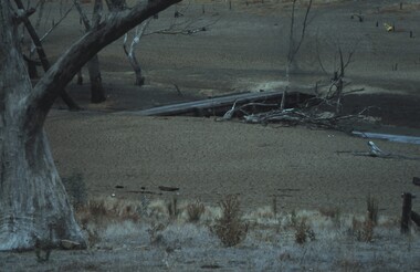
Slide - VAL DENSWORTH COLLECTION: DRY LAKE EPPALOCK, May 2004
Slide. Dry Lake Eppalock. A low bridge over the river.slide, bendigo, dry lake eppalock., dry lake eppalock. -
 Bendigo Historical Society Inc.
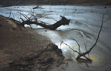
Slide - VAL DENSWORTH COLLECTION: DRY LAKE EPPALOCK, May 2004
Slide. Dry Lake Eppalock. Mud pool in the River system.slide, bendigo, dry lake eppalock., dry lake eppalock. -
 Bendigo Historical Society Inc.
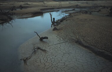
Slide - VAL DENSWORTH COLLECTION: DRY LAKE EPPALOCK, May 2004
Slide. Dry Lake Eppalock. River pools in Lake Eppalock.slide, bendigo, dry lake eppalock., dry lake eppalock. -
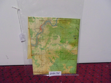 National Vietnam Veterans Museum (NVVM)
Map
A laminated coloured map of the Son River, Dang Nai, Vietnammap, 3rar, mcphail collection -
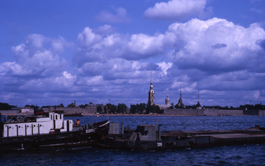 Robin Boyd Foundation
Slide, Robin Boyd, 1964
In 1964, Robin and Patricia Boyd spent several weeks on a world tour - Boyd took a leading role at the International Design Conference in Aspen and he also visited Chicago, Yale University, and New York’s World Fair. The Boyds then travelled on to England, Finland (especially to see Tapiola), Russia and India to see Le Corbusier's Chandigarh, and also Hong Kong and Thailand.Colour slide in a mount. River views, unknown location, RussiaMade in Australia / 33 / AUG 64Mrussia, slide -
 University of Melbourne, Burnley Campus Archives
Document, Cumbungi, 1970-1980
Flyer by W.A.E. Graham, State Rivers and Water Supply Commissionw.a.e. graham, state rivers and water supply commission -
University of Melbourne, Burnley Campus Archives
Slide - Glass slide, 1891-1905
'B 19. London', UK, buildings beside the River Thames.overseas images, river thames -
Lakes Entrance Regional Historical Society (operating as Lakes Entrance History Centre & Museum)
Photograph, Joyhn Flynn, 1906
This is a photographic proof on light cardBlack and white photograph of Coates Bluff on Buchan River VictoriaJohn Flynn Postcards from Buchanbridges, waterways -
Lakes Entrance Regional Historical Society (operating as Lakes Entrance History Centre & Museum)
Photograph, Rev John Flynn, 1906
Photographic proof on light cardboardBlack and white photograph of the Snowy River at Quails Buchan VictoriaThe Snowy near Buchanwaterways -
Lakes Entrance Regional Historical Society (operating as Lakes Entrance History Centre & Museum)
Postcard, H D Bulmer, 1907 c
Letter on back to Miss Evans Linia East via BenallaSepia postcard of view of Snowy River at Dickens Knob Victoriawaterways, roads and streets -
Clunes Museum
Postcard
CARD SHOWING RIVER WITH A STATUE IN THE MIDDLE WITH TREES LINING THE BANKSlocal history, document, postcards, postcards -
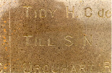 Whitehorse Historical Society Inc.
Photograph, TILL Sydney
Sepia photograph - an enlargement of inscription at cenotaph at Clarence River. TILL.S.N.war memorials, till, sydney -
 Whitehorse Historical Society Inc.
Card - Post card
Postcard to Graeme McNamara, NumurkahPostcard " The Latrobe Valley Yellow Power Station and The Latrobe River'.Nu - Color - Vue of Australiapost card, latrobe valley, yellow power station -
Lakes Entrance Regional Historical Society (operating as Lakes Entrance History Centre & Museum)
Photograph, 1977 c
Polish scientist explorer Dr. Lhotsky explored the Australian Alps south of Mt Kosciusko (not named at that date)as far as McKillops Bridge (unnamed then) between 1834 and 1839. His claims were largely ignored he being labelled imposter and humbug but recent research indicates his rightful place amongst Victorias early explorersBlack and white photograph of Snowy River at Suggan Buggan VictoriaApproximately where John Lhotsky the first white man known to have been in Gippsland reached the Snowy and spent three days in March 1834topography -
 Running Rabbits Military Museum operated by the Upwey Belgrave RSL Sub Branch
Model
WW2 USA Armor Recon Officer. Muese River 1944model -
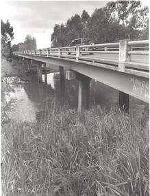 Bendigo Historical Society Inc.
Photograph - PHOTOGRAPH. ELMORE. BRIDGE OVER CAMPASPE RIVER, 1993
Photograph. Elmore. Vehicle passing on bridge over Campaspe River. -
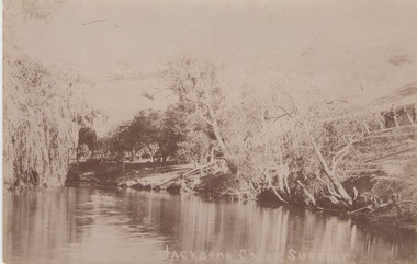 Sunbury Family History and Heritage Society Inc.
Photograph
The postcard features a view of the Jacksons Creek in Sunbury. Before settlement, Jacksons Creek was the main source of water in Sunbury. It flows from the Macedon Ranges and is an important arm of the Maribyrnong River. A sepia photograph in post card format of a view of a river in the country. JACKSONS CREEK SUNBURYjacksons creek, sunbury -
University of Melbourne, Burnley Campus Archives
Booklet, State Rivers and Water Supply Commission, Revegetating Victorian Streams, 1982
streams, revegetation -
 Orbost & District Historical Society
sash, 1988
This was presented to Mrs Norma Crowe for Best Period Costume in 1988.This item is associated with an event in Orbost from the second half of the 20th century.A sash made of white material with blue flock printing glued on. It has a red fringe.SNOWY RIVER MARLO CUP BEST PERIOD COSTUME 1988sash marlo-cup -
Tatura Irrigation & Wartime Camps Museum
Book, Pioneers of Victorian Irrigation, 1976
Soft cover, white with black writing. Photos of 10 important Pioneers of IrrigationPioneers/of Victorian/Irrigation/State Rivers and Water Supply Commissionirrigation pioneers, tatura, books, reference -
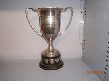 Wangaratta High School
WHS Trophy- Sport, 1931-1967
Gold metal elongated cup trophy with a brown plastic base and silver metal shields attached to the bottom. Engraved in the cup is:N.E.D.S.S.S.A. Football Premiership Donated by BROKEN RIVER HURIER ________ Benella -
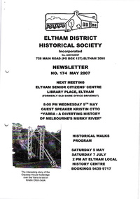 Eltham District Historical Society Inc
Newsletter, Newsletter, No. 174 May 2007
Contents: • Next meeting, guest speaker; Kristin Otto: Yarra; A Diverting History of Melbourne’s Murky River • May Meeting • President’s Report • Pat Baddeley’s Story (continued) • Fortieth Anniversary Celebrations • Office Bearers 2007-8 • Subscriptions • Other News The Shire of Eltham Historical Society was formed in October 1967. The first newsletter of the Society was issued May 1978 and has been published continuously ever since on a bi-monthly basis. With the cessation of the Shire of Eltham in late 1994, the Society's name was revised to Eltham District Historical Society and this name first appeared with issue No. 103, July 1995. The collection of the Society's newsletters provides a valuable resource on the history of the Society's activities, office bearers and committee members, guest speakers and subjects of historical interest pertinent to the former Shire of Eltham and the Eltham District.A4 photocopied newsletter distributed to membersnewsletter, eltham district historical society, shire of eltham historical society -
 Running Rabbits Military Museum operated by the Upwey Belgrave RSL Sub Branch
Painting (size5)
Oil Painting Australian Grimsby Class Destroyer Flotilla, (sister ships Swan, Yarra, Parramatta & Warrego.)picture, ww1, ran -
Port Melbourne Historical & Preservation Society
Photograph - Sandridge railway bridge over Yarra River, Melbourne, Douglas Smallpage, 1970s
B&W photos of various locations in Port Melbourne Sandridge railway bridge over Yarra in MelbourneSeveral have descriptions of locations in pencil on rear of photostransport - railways, sandridge railway -
 Kew Historical Society Inc
Photograph - Demolishing the Zig-Zag Bridge, 1929
Henry Beater Christian (1886-1962) , was a descendant of one of the earliest settler families in Kew. Employed at the Kew Asylum as a 'public servant', he was a skilled amateur photographer, photographing numerous scenes in Kew and on his travels around Victoria. The majority of his photographs date from 1916 to 1929. His finest photographs are housed in two photograph albums. Rare photograph of the demolition of the Zig-Zag Bridge linking the two asylums on either side of the Yarra River.Digital copy of a photograph from page 16 of the 47-page photograph album containing 261 gelatinous silver images, loaned by Diane Washfold with permission given to digitise and hold a copy in our collection. The Zig-Zag Bridge linked the grounds of the Yarra Bend and Kew Asylums. The wooden bridge was constructed in the 1870s and lasted through numerous floods until its destruction in 1929. A horizontal structure, the walkway was reached via a wooden staircase on the Kew bank of the river. The steps were required due to the different levels of the banks on this stretch of the river. This night-time photograph shows the remaining parts of the bridge being destroyed by fire."Demolishing Zig-Zag / 6. 1929"henry beater christian (1886-1962), landscape photography, kew (vic.) — yarra river, christian-washfold collection, photograph albums, zig-zag bridge -
 Kew Historical Society Inc
Map, MMBW, MMBW Plan No.117 Heidelberg & Kew, 1900-1910
The Melbourne and Metropolitan Board of Works (MMBW) was established by an act of the Victorian Parliament in 1890 to prepare for and to implement a sewerage and water reticulation system across what was then inner Melbourne, its surrounding and middle distance suburbs, including Kew. The MMBW was disbanded in 1991.The map collection of the Kew Historical Society has at its core the historic maps assembled and originally stored in the City Engineer's Department of the City of Kew. These include maps in a number of scales. The vast majority of maps were produced by the MMBW in the first two decades of the twentieth century, and are solid working maps, backed by linen for durability. These maps are historically significant to Kew, the City of Boroondara and to the history of the development of state utilities in Victoria. A number of the Kew maps have additional details added by former municipal officers, including the levels reached by various floods. As these were working documents, information was added to them long after the period of their initial production and distribution.Early map of part of the Borough of Kew, created in the early twentieth century, at a scale 160 ft to 1 inch. The map covers what was then the north eastern part of Kew showing the natural landscape and limited development on the south side of the Yarra River. In the Kew section, south of the river, the land is occupied currently by the Greenacres and Kew Golf Clubs. The map shows the extent of urban development by that time and the outlines of the few built structures in the municipality. The height above sea level of all parts of the landscape are indicated numerically in feet. Contour lines and the levels of historic floods were added in ink to the map at a later stage. MELBOURNE AND METROPOLITAN BOARD OF WORKS / PLAN NO. 117 / HEIDELBERG & KEW melbourne & metropolitan board of works, mmbw maps, borough of kew, cartography, mmbw plan no. 117, kew (vic.) -- maps, heidelberg (vic.) -- maps -
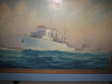
 Bendigo Military Museum
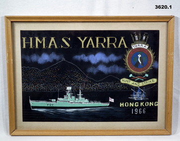
Painting - PAINTINGS NAVY, FRAMED, Post 1966 & 1968
Original owner Graham John HAINES R94437, PORS - Petty Officer Radio Supervisor, RAN Comms, Vietnam & FESR..1) Framed painting by disabled artist in Hong Kong. Coloured painting of HMAS Yarra on black background. Tan wooden frame, cream border, glass front. Cardboard backing with wire hanging strap. .2) Framed painting by disabled artist in Hong Kong. Coloured painting of HMAS Parramatta a on black background. Tan wooden frame, cream border, glass front. Cardboard backing with white cord hanging strap..1) Printed at top: “HMAS YARRA” Emblem RHS: “RAN FAR EAST FLEET HUNT AND STRIKE” Printed bottom RHS: “HONG KONG 1966” .2) Printed at top: “HMAS PARRAMATTA” Emblem RHS: “RAN FAR EAST FLEET STRIKE DEEP” Printed bottom RHS: “HONG KONG 1968” painting, hmas, hong kong -
 Orbost & District Historical Society
black and white photographs, Jude, Ray, 1915 - 1969
These photographs relate to the East Gippsland Railway. The Bairnsdale-Orbost railway was opened in 1916 to serve the agricultural and timber industry. Because of the decline in traffic and heavy operating costs, the line was finally closed in August, 1987. Orbost Railway Station was opened on Monday 10 April 1916 as the terminus of the Orbost railway line, and closed in 1987. The station was located on the west side of the Snowy River despite the town of Orbost being on the east side of the river, in order to save on the costs of a bridge over the river, which at the time had highly variable levels. These photographs are associated with the history of the Orbost-Bairnsdale railway line and therefore reflects the role that the rail line played in the social and economic history of Orbost.Seven black / white photographs and one postcard print.3103.1 on back - " Orbost- Snowy River flats viaduct 22-2-1964 ARHS special train Ray Jude photo" 3103.2 - on back -" Orbost Snowy River flats viaduct A.R.H.S. special train 22.2.1969" 3103.3 - on back - " A.R.H.S. special across bridge between Waygara & Nowa Nowa 22-2-1964 3103.4 - on back - " Nowa Nowa Boggy Creek Bridge A.R.H.s. Orbost tour Ray Jude photo" 3103.5 - on back - " Orbost 22-2-1969 SM office & goods shed Ray Jude photo" 3103.6 - on back - " Orbost Railway Yards - 22 February 19369 Ray Jude photo" 3103.7 - on back - " Orbost May 27 -1936 Orbost Rail Station" 3103.8 - on front - caption - Unloading Ballast Orbost line near Newmerella 1915 - J. Sullivan Colin ?orbost-railway east-gippsland-railway bairnsdale-orbost-railway