Showing 10880 items
matching land
-
 Glen Eira Historical Society
Document - Lyall Family
Handwritten document on William Lyall’s grants of land, from rate books dated 1857 to 1872, unsigned and undated.lyall william, caulfield, elsternwick, frogmore, koornang, stables, timber houses, brick and timber houses -
 Greensborough Historical Society
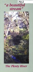
Pamphlet, Friends of the Plenty River, "a beautiful stream": The Plenty River, 2004_04
A publicity pamphlet for "Friends of the Plenty River", a group formed in 1995 to help rehabilitate the Plenty River and adjacent land.2 p., illus., map. Tri-fold pamphlet.plenty river, lower plenty, friends of the plenty river -
 Greensborough Historical Society
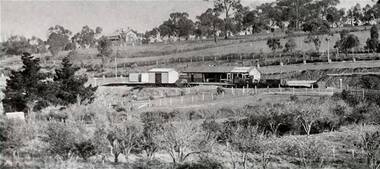
Photograph - Digital Image, Greensborough Station, early 1900s, 1910_
Greensborough Station pre-World War I. The orchard on the land in the foreground is now Poulter Avenue and Pope Place.Shows the rural nature of the Greensborough area in the early 20th centuryDigital copy of black and white photograph. trains, greensborough railway station, poulter avenue greensborough, pope place greensborough -
Greensborough Historical Society
Newspaper clipping, 17 Watsonia home sites sell for 1585 [pounds] average, 1950c
A scrap of newspaper with land prices in Watsonia's "Hillboro" estate. Prices are pre-decimal currency, estimated mid 1950s.AN indication of land prices in the 1950s.Torn clippingwatsonia -
![Document, Town Planning Appeals Tribunal, Town Planning Appeals Tribunal report 1978 [Loyola College], 06/11/1978](/media/collectors/4f729f5697f83e03086015b8/items/58bbb237d0cdef1bcc864955/item-media/58bbb35fd0cdef1bcc8683be/item-fit-380x285.jpg) Greensborough Historical Society
Greensborough Historical SocietyDocument, Town Planning Appeals Tribunal, Town Planning Appeals Tribunal report 1978 [Loyola College], 06/11/1978
Report on an appeal against two conditions on the development of land in Grimshaw Street Watsonia for a secondary school [Loyola College].This document demonstrates some of the problems associated with setting up a school in a residential area.3 pages, torn and yellowed.loyola college -
 Greensborough Historical Society
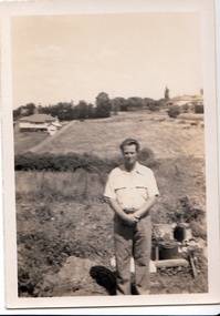
Photograph - Digital image, John Gibson et al, Keith Luxford in Main Street backyard 1950, 1950_01
Keith Luxford in backyard in January 1950, Grimshaw Street behind; and at left; a new horse on Mr Starling's land.Digital copy of black and white photograph. luxford family, grimshaw street greensborough -
 Friends of the Cerberus Inc
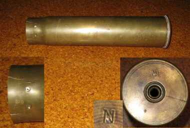
6 pounder Shell casing, 1889
Nordenfelt Six pounder quick firing guns were used by land and naval forces to counter torpedo boats.The projectile and its shell casing are of the type and age used by the Victorian Naval Forces but could equally have been used by the land forces.Cylindrical brass tube closed at base and open at other end.victorian naval forces, victorian navy, nordenfelt quich firing gun, ammunition -
 Friends of the Cerberus Inc
6 pounder Common Shell, 1888
Nordenfelt Six pounder quick firing guns were used by land and naval forces to counter torpedo boats.The projectile and its shell casing are of the type and age used by the Victorian Naval Forces but could equally have been used by the land forces.Cylindrical steel shell with cone shaped nose.On side - "H/88"common shell, hotchkiss, 6 pounder, ammunition -
 Warrnambool and District Historical Society Inc.
Map - City of Warrnambool Freehold and Managed Crown Land, City of Warrnambool Council, 14th April 1994
This map was drawn up by the City of Warrnambool Council staff to provide information on the land in Warrnambool that was owned or managed by the Council.This map is of considerable importance as it gives information in map form of the Warrnambool land that is owned (freehold) by the City of Warrnambool and the land that is managed Crown land. This is of interest to researchers and those seeking information on specific areas of land in Warrnambool.This map has digital mapping. The map has a white background with black and white mapping details of Warrnambool. It has the City of Warrnambool seal. Scale of map: 1:7500warrnambool city council, warrnambool -
 Eltham District Historical Society Inc
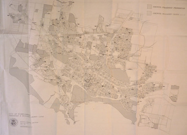
Document, Notice of Decision to Grant a Permit; Ref: E94/306 - Subdivision of 30-34 Diosma Road; 16 November 1994, 16/11/1994
This permit was eventually overturned following community objection and the land was donated by Yarra Valley Water for use as a community reserve.The Stokes Orchard Estate collection is typical of housing developments of the late 1970s and 1980s. It was one of the earliest estates in Eltham following the nearby Woodridge Estate development.A4 document consisting of ten pagesAs notedstokes place, eltham, stokes orchard, stokes orchard estate, streets, houses, peter and carla vermey, diosma road, letter of objection, melbourne metropolitan board of works, planning application, reservoir, shire of eltham -
Ringwood and District Historical Society
Book - Eureka Plan, Farmer, Mr, Eureka Plan, c. 1930
Created to assist in promotion and sale of land near Ringwood Railway station, following completion of the electric rail to Ringwood..Book containing details of seven delightful and valuable Ringwood properties - Bestpart, Paradur, Hill Top, Greenwood, Creek, Station and School estates. The book has 16 photos and 20 plans and 20 pages. There are multiple copies of pages 20x2; 19x2; 18x4; 17x4 and 20x2. +Additional Keywords: Farmer, Mr -
 City of Moorabbin Historical Society (Operating the Box Cottage Museum)
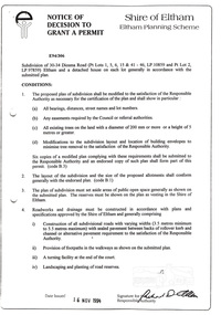
Flyer - Hawthorn Road Tramway Estate, Garden Vale, 1920
At the end of World War One, there was a renewed interest in residential land and a number of estates opened up in the Municipality of Moorabbin.Example of the progress of the Municipality of MoorabbinAdvertising flyer for auction of real estate sales - plan of building blocks for saleHawthorn Road Tramway Estate, Auction 6 March 1920, 82 building allotmentshawthorn road, jupiter street, raynes street, saturn street, ludbrook avenue, wawn street, lucas street, garden vale, real estate, acution, moorabbin -
 City of Moorabbin Historical Society (Operating the Box Cottage Museum)
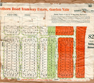
Flyer, 1922
At the end of World War One, there was a renewed interest in residential land and a number of estates opened up in the Municipality of Moorabbin.Example of the progress of the Municipality of MoorabbinAdvertising flyer for auction of real estate sales - plan of building blocks for saleThe O'Neill College Estate, Elsternwick - Auction Saturday 8 April 1922denver street, brentani avenue, railway cresent (now riddell parade), elsternwick, real estate, auction -
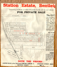 City of Moorabbin Historical Society (Operating the Box Cottage Museum)
Flyer - Station Estate, Bentleigh
At the end of World War One, there was a renewed interest in residential land and a number of estates opened up in the Municipality of Moorabbin.Example of the progress of the Municipality of MoorabbinAdvertising flyer for private sale of real estate sales - plan of building blocks for saleStation Estate, Bentleigh, for private sale 20 blocks unsold.atkinson street, ardwick street, ethel street, jasper road, bentleigh, real estate, auction -
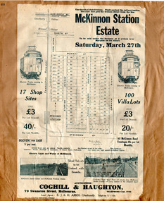 City of Moorabbin Historical Society (Operating the Box Cottage Museum)
Flyer - The Railway Estate, McKinnon, 1920
At the end of World War One, there was a renewed interest in residential land and a number of estates opened up in the Municipality of Moorabbin.Example of the progress of the Municipality of MoorabbinAdvertising flyer for auction of real estate sales - plan of building blocks for saleMcKinnon Station Estate - 100 Villa lots & 17 business lots - Auction Saturday 27 March 1920mckinnon station estate, graham ave, prince edward ave, station street, mckinnon road, real estate, mckinnon, auction, moorabbin -
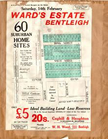 City of Moorabbin Historical Society (Operating the Box Cottage Museum)
Flyer - Ward's Estate, Bentleigh, 1920
At the end of World War One, there was a renewed interest in residential land and a number of estates opened up in the Municipality of Moorabbin.Example of the progress of the Municipality of MoorabbinAdvertising flyer for auction of real estate sales - plan of building blocks for saleWard's Estate Bentleigh Auction Saturday 14 February 1920centre road, smith street, ross street, jasper road, bentleigh, real estate, auction -
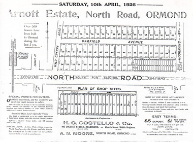 City of Moorabbin Historical Society (Operating the Box Cottage Museum)
Flyer - Arnott Estate, North Road, Ormond
At the end of World War One, there was a renewed interest in residential land and a number of estates opened up in the Municipality of Moorabbin.Example of the progress of the Municipality of MoorabbinPhotocopy of Advertising flyer for auction of real estate sales - plan of building blocks for saleArnott Estate, North Road, Ormond. Auction Satire 10 April 1926 - 42 home sites & 20 shop sitesnorth road, ormond, real estate, auctions, garfield avenue -
 City of Moorabbin Historical Society (Operating the Box Cottage Museum)
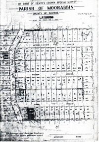
Flyer - Garfield Estate, Ormond
At the end of World War One, there was a renewed interest in residential land and a number of estates opened up in the Municipality of Moorabbin.Example of the progress of the Municipality of MoorabbinPhotocopy of the plan of the Garfield Estate, OrmondPart f Dendy's Crown Special Survey - parish of Moorabbin - County of Bourke - Garfield Estatedraper street, lord street, hudson street, blackshaw street, tucker road, ormond, mckinnon, real estate -
 City of Moorabbin Historical Society (Operating the Box Cottage Museum)
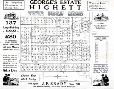
Flyer - George's Estate, Highett
At the end of World War One, there was a renewed interest in residential land and a number of estates opened up in the Municipality of Moorabbin.Example of the progress of the Municipality of MoorabbinAdvertising flyer for auction of real estate sales - plan of building blocks for saleGeorge's Estate Highett - 137 building blocksgeorge street, haynes street, dorothea street, barnett street, rose street, highett road, highett, real estate, auctions -
 City of Moorabbin Historical Society (Operating the Box Cottage Museum)
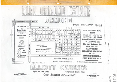
Flyer - Glen Ormond Estate, Ormond
At the end of World War One, there was a renewed interest in residential land and a number of estates opened up in the Municipality of Moorabbin.Example of the progress of the Municipality of MoorabbinPhotocopy of advertising flyer for sale of real estate sales - plan of building blocks for saleGlen Ormond Estate - For Private Sale - Home Sitesoakleigh road, ormond parade, kooringa road, leila road, huntly avenue, ormond, real estate -
 City of Moorabbin Historical Society (Operating the Box Cottage Museum)
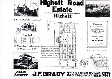
Flyer - Highett Road Estate, Highett
With the growth of Melbourne the market gardens were subdivided into building blocks as the land was worth more than the value of the crops.Example of the progress of the Municipality of MoorabbinPhotocopy of advertisement of private sale of housing lots in Highett.Highett Road Estate, Highett - 85 Magnificent Allotmentshighett road, wilson st, dalmont street, highett, real estate -
 City of Moorabbin Historical Society (Operating the Box Cottage Museum)
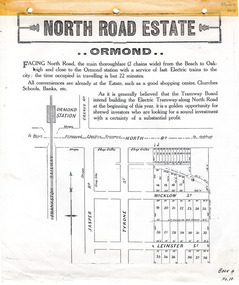
Flyer - North Road Estate, Ormond
At the end of World War One, there was a renewed interest in residential land and a number of estates opened up in the Municipality of Moorabbin.Example of the progress of the Municipality of MoorabbinAdvertising flyer for auction of real estate sales - plan of building blocks for saleNorth Road Estate, Ormond - plan of subdivision.36north road, wicklow st, leinster st, ormond, real estate -
 City of Moorabbin Historical Society (Operating the Box Cottage Museum)
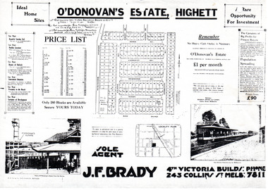
Flyer - O'Donovan's Estate, Highett
At the end of World War One, there was a renewed interest in residential land and a number of estates opened up in the Municipality of Moorabbin.Example of the progress of the Municipality of MoorabbinAdvertising flyer for auction of real estate sales - plan of building blocks for saleO'Donovan's Estate Highett - 180 blocksjames ave, clonmult ave, desmond av, mary av, bay road, cloyne street, middleton st, real estate, highett -
 City of Moorabbin Historical Society (Operating the Box Cottage Museum)
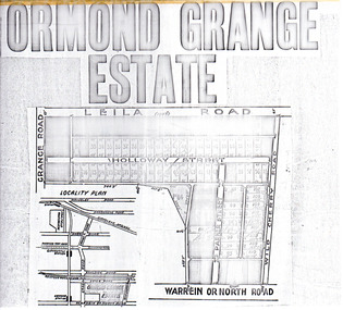
Flyer - Ormond Grange Estate, Ormond, 1913
At the end of World War One, there was a renewed interest in residential land and a number of estates opened up in the Municipality of Moorabbin.Example of the progress of the Municipality of MoorabbinPhoto copy of advertising flyer for auction of real estate sales - plan of building blocks for saleOrmond Grange Estateholloway street, wild cherry road, parker street, ormond, land sales, real estate -
 City of Moorabbin Historical Society (Operating the Box Cottage Museum)
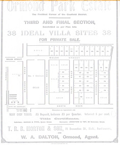
Flyer - Ormond Parke Estate, Ormond, 1913
At the end of World War One, there was a renewed interest in residential land and a number of estates opened up in the Municipality of Moorabbin.Example of the progress of the Municipality of MoorabbinPhotocopy of advertising flyer for private sale of real estate sales - plan of building blocks for saleOrmond Parke Estate, Ormond - Third and final section for private salewalsh st, ormond road, park road, nicholls road, ormond, real estate -
 Uniting Church Archives - Synod of Victoria
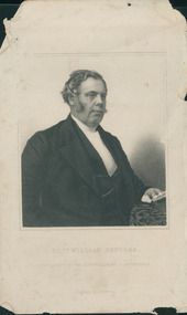
Print, C1870
Rev. William Butters (1810-1887) commenced his ministry as a chaplain to the convicts in Van Diemen’s Land in 1833.Print of an engraving by J. Cochran of Rev. William Butters in frame.butters, w, methodist -
Whitehorse Historical Society Inc.
Document - Report, The History of Yarran Dheran Nature Reserve, 2020
The time line history of Yarran Dheran Nature Reservenon-fictionThe time line history of Yarran Dheran Nature Reserveyarran dheran, wurunjeri, yarran dheran advisory committee -
 Otway Districts Historical Society
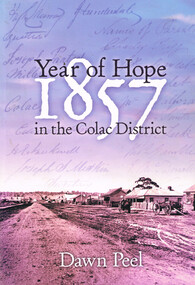
Book, Year of hope: 1857 in the Colac District, 2006
The land, the settlers, and the social institutions which found or altered the character of the small settlement of Colac, Victoria, and its district.Year of hope: 1857 in the Colac district. Dawn Peel. 1st ed. Colac (Vic); Dawn Peel; 2006. x, 212 p.; illus, bibliography. Soft cover. ISBN 0 646 46270 9For Irene - a fellow historian. Dawn Peel. 6/10/06.1857; dawn peel; land; politics; aborigines; religion; history; social institutions; -
 Kew Historical Society Inc
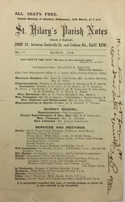
Pamphlet - Document, St Hilary's Anglican Church, St Hilary's Parish Notes, No.70., March 1919, 1919
St Hilary's Anglican Church in Rowland Street, Kew was established in 1888 on land granted to the congregation by the Dumaresq family.The Parish Notes are historically interesting as they outline the various ways in which the Influenza Epidemic of 1919 had an impact on local communities. St Hilary's Church of England Parish Notes from 1919, which includes among other items of interest states that because of the risks of contagion during the influenza epidemic, parishioners are required to worship outside. Written note on front page signed by the Rev Charles H Barnes and dated 16/3/19.st hilary's church of england - kew (vic), churches - kew (vic), influenza epidemic 1919 - kew (vic) -
 Melton City Libraries
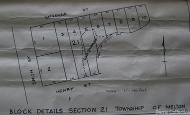
Map, Block details section 21 Township of Melton, 1965
In 1861, Mary Dowling and John Luby obtained Crown Grant land on the corner of Smith and McKenzie Street Melton.Section 21 is covers the block of Smith, Henry and McKenzie Street Meltoncouncil