Showing 3906 items matching "bricker"
-
 Flagstaff Hill Maritime Museum and Village
Equipment - Pattern, Briggs Brass Foundry, Early 20th century
The wooden pattern is part of a set that is stored in a strong wooden crate and may be part of another similar pattern. It was used at Briggs’ Brass Foundry for making sand casts. The traditional craft of sand casting is over 2000 years old. The handcrafted process produces brass and copper alloy goods that are well suited to marine use; bells, boat hooks, cowls, propellers, handles, lids, rowlocks, hooks, letters, bolts, rail holders, brackets, deck plates, flanges, rudder guides, portholes and covers. Briggs’ Bronze mixture is a copper-based alloy made from local ingots of copper, tin, zinc and lead in carefully measured quantities. The finished product is non-ferrous and can last indefinitely. The crate of patterns was donated by the Briggs family in the early years of Flagstaff Hill, along with other related items such as brassware, tools and machinery. The donated items were displayed in a simulated Brass Foundry in the Village along with other working crafts, trades and services found in a Maritime town. The items were on show from the completion of the building in 1986 until 1994 when the building was repurposed. The patterns represent the trades of foundering and metalwork, both supporting maritime industries such as shipwrights and boatbuilders. Farmers, manufacturers and other local industries also needed the castings made by foundries. The Brass Foundry included a historic Cornish chimney set up as a working model, to tell the story of smelted metal heated in furnaces then be poured into the sand moulds. This chimney was made from specially curved bricks and is now about two-thirds of its full height when originally located at the Grassmere Cheese factory. The craft of sand-casting from carved wooden patterns to create metal is an example of skills from the past that are still used today. The foundry pattern set is significant for its association with brass foundries locally and generally in coastal areas of Victoria. Marine industries such as ship and boat building rely on good quality castings for their machinery, equipment and fittings. Briggs Brass was especially formulated using non-ferrous metals to ensure their longevity. The patterns are associated with the long-running firm Briggs Brass Foundry that specialised in cast goods for the marine industry, ready to supply the needs for once-off or mass-produced items. Their products would have been fitted to sail and steam vessels along coastal Victoria including Warrnambool. Briggs Marine was also a bell-founder specialist and is also associated with the Schomberg Bell at Flagstaff Hill, having restored it to is former state as a fine example of the bell from a luxury migrant vessel from the mid-19th century. Pattern; unpainted, square wooden block with a semi-circle of dowel added to the centre of the side with rounded corners. Three short dowel pegs are inserted on one flat side; one below the semi-circle and one near the lower corners in an overall triangle configuration. The pattern is part of a set of foundry patterns from Briggs Brass Foundry.flagstaff hill, flagstaff hill maritime museum and village, warrnambool, maritime museum, maritime village, great ocean road, shipwreck coast, briggs' bronze, traditional method, trade, sand cast, cast, brass alloy, copper alloy, pattern, mould, foundry, brass foundry, metal foundry, casting, sand mould, sand casting, marine equipment, marine tools, marine fittings, copper tin zinc lead, non-ferrous, non-corrosive, brassware, metalware, foundering, metalwork, maritime, bell founders, ship chandlers, marine products, biggs, briggs family, herbert harrison briggs, h h briggs, george edward briggs, cyril falkiner mckinnon briggs, cyril briggs, briggs & son brass foundry, h h briggs & sons foundry, briggs marine, alliance casting & engineering solutions, grassmere cheese factory, cornish chimney, curved bricks, collingwood, moorabbin, collingwood foundry, moorabbin foundry, 1912 -
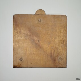
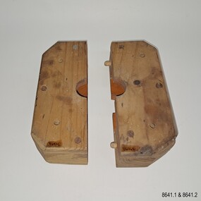 Flagstaff Hill Maritime Museum and Village
Equipment - Pattern, Briggs Brass Foundry, Early 20th century
The wooden patterns are part of a set that are stored in a strong wooden crate. It was used at Briggs’ Brass Foundry for making sand casts. It may fit together with one of the other patterns with a similar outline. The traditional craft of sand casting is over 2000 years old. The handcrafted process produces brass and copper alloy goods that are well suited to marine use; bells, boat hooks, cowls, propellers, handles, lids, rowlocks, hooks, letters, bolts, rail holders, brackets, deck plates, flanges, rudder guides, portholes and covers. Briggs’ Bronze mixture is a copper-based alloy made from local ingots of copper, tin, zinc and lead in carefully measured quantities. The finished product is non-ferrous and can last indefinitely. The crate of patterns was donated by the Briggs family in the early years of Flagstaff Hill, along with other related items such as brassware, tools and machinery. The donated items were displayed in a simulated Brass Foundry in the Village along with other working crafts, trades and services found in a Maritime town. The items were on show from the completion of the building in 1986 until 1994 when the building was repurposed. The patterns represent the trades of foundering and metalwork, both supporting maritime industries such as shipwrights and boatbuilders. Farmers, manufacturers and other local industries also needed the castings made by foundries. The Brass Foundry included a historic Cornish chimney set up as a working model, to tell the story of smelted metal heated in furnaces then be poured into the sand moulds. This chimney was made from specially curved bricks and is now about two-thirds of its full height when originally located at the Grassmere Cheese factory. The craft of sand-casting from carved wooden patterns to create metal is an example of skills from the past that are still used today. The foundry pattern set is significant for its association with brass foundries locally and generally in coastal areas of Victoria. Marine industries such as ship and boat building rely on good quality castings for their machinery, equipment and fittings. Briggs Brass was especially formulated using non-ferrous metals to ensure their longevity. The patterns are associated with the long-running firm Briggs Brass Foundry that specialised in cast goods for the marine industry, ready to supply the needs for once-off or mass-produced items. Their products would have been fitted to sail and steam vessels along coastal Victoria including Warrnambool. Briggs Marine was also a bell-founder specialist and is also associated with the Schomberg Bell at Flagstaff Hill, having restored it to is former state as a fine example of the bell from a luxury migrant vessel from the mid-19th century. Pattern; a pair of blocks that form a rectangle with a carved centre hole and disc shape inside. The block is made from laminated pieces of wood with cut corners. Both sides have four drilled holes in a square configuration but in different positions. The cut faces and the space carved into them are painted red; one piece has two dowel pins that fit into two drilled holes on the other. The pattern is part of a set of foundry patterns from Briggs Brass Foundry.flagstaff hill, flagstaff hill maritime museum and village, warrnambool, maritime museum, maritime village, great ocean road, shipwreck coast, briggs' bronze, traditional method, trade, sand cast, cast, brass alloy, copper alloy, pattern, mould, foundry, brass foundry, metal foundry, casting, sand mould, sand casting, marine equipment, marine tools, marine fittings, copper tin zinc lead, non-ferrous, non-corrosive, brassware, metalware, foundering, metalwork, maritime, bell founders, ship chandlers, marine products, biggs, briggs family, herbert harrison briggs, h h briggs, george edward briggs, cyril falkiner mckinnon briggs, cyril briggs, briggs & son brass foundry, h h briggs & sons foundry, briggs marine, alliance casting & engineering solutions, grassmere cheese factory, cornish chimney, curved bricks, collingwood, moorabbin, collingwood foundry, moorabbin foundry, 1912 -
 Wodonga & District Historical Society Inc
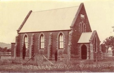
Photograph - Saint John's Lutheran Church, Wodonga
From the mid-1860s families of German ancestry arrived in the Wodonga district, travelling in groups from South Australia. The majority of these people were of the Lutheran religion. At first there was no Lutheran pastor or church in the area and they held services under the gum trees or in their homes once they had been built. The early arrivals included the Haeusler, Klinge, Bartel, Rothe and Paech families. They were later joined by members of the Muller, Lange, Pumpa, Lobbe, Heckendorf, Zeinert, Schubert, Schuster, Schubert and Terlich families amongst others. The first Lutheran Church was built in Havelock Street, Wodonga and was dedicated in 1875. This building was used for approximately 90 years until it was demolished and replaced by a temporary building and then a second church which was dedicated in 1978. The Ovens and Murray Advertiser on 4th August 1874 reported "The Rev. Goessling pastor of the German Lutheran Church, Gerogery has laid the foundation stone of the new church for the members of his denomination residing at Wodonga, in accordance with the rights of the church. The building was to be 30 feet by 20 feet and 14 feet high, of brick with white facings and Gothic windows. There was to be a porch and vestry, one at either end, measuring 8 feet by 10 feet". Plans were initiated to build a new church from the late 1990s. After many years of planning and hard work, the last service in the Saint John’s Lutheran Church in Havelock Street was held on Sunday 7th May 2023 and a new Church was constructed. From 14th May 2023 the Parish held its worship services in Luther Hall at Victory Lutheran College in Drage Road, West Wodonga. The new Saint John’s Church was consecrated on 18 August 2024.This photo is significant because it depicts the original Lutheran Church in Wodonga.A black and white photograph of an old stone church building.Lutheran Church Wodongawodonga churches, lutheran church wodonga -
 Eltham District Historical Society Inc
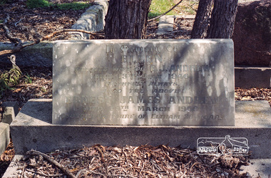
Negative - Photograph, Harry Gilham, Grave of Ellen and Ernest James Andrew, Eltham Cemetery, Victoria, Sep 2009
Ernest James Andrew was the son of William Bravery and Ellen Andrew. The Andrews moved to Eltham in the 1850s and opened a produce store on "Policeman's Hill", at the corner of Maria Street (now Main Road) and Franklin Street. William took a lively interest in the public affairs of the town and district, and with his wife Ellen continued to run the store for some fifty years. He died in 1907 and is buried with his wife in Eltham Cemetery. Ernest took over the business, which became a general store and newsagency. Later, it shifted to the main Eltham shopping centre as a combined newsagency and haberdashery/clothing shop. The original weatherboard building at the corner of Franklin Street was replaced around 1940 by a brick structure, which is now a cafe called Zen Den. Ernie too was married to an Ellen and they lived in Arthur Street at so-called "Cook's Cottage" (due to its resemblance to Captain Cook's Cottage in Fitzroy Gardens). He was an Eltham Shire Councillor between 1920 and 1950 and was Shire President for 1930 and 1947 as well as a Trustee for the Eltham (Public) Hall in Henry Street from the time it was purchased in 1922 until 1940. Andrew House at Eltham High School and Andrew Oval in Diamond Street are named after him. Ernie died in 1950 and is buried with Ellen in Eltham Cemetery. In his Will he made provision to the Eltham War Memorial Trust for funding of the Eltham War Memorial Gates – “These Memorial Gates were donated by the Late Cr. And Mrs E.J. Andrew”. In Memory Of Ellen Beloved Wife of E.J. Andrew Died 13th July 1946 Faithfull Always Also the Above Ernest James Andrew Died 29th March 1950 Councillor Shire of Eltham 30 YearsRoll of 35mm colour negative film, 6 stripsKodak GC 400-9eltham cemetery, gravestones, councillors, ellen andrew, ernest james andrew, shire of eltham -
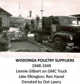 Wodonga & District Historical Society Inc
Photograph - Wodonga Poultry Suppliers, Late 1940s
Wodonga Poultry Suppliers was established in the late 1940s by Albert (Bert) Elkington in partnership with his father-in-law Artie Phillips and Aubrey Gilbert. From the beginning they had an eye on the export market. Artie (Arthur) Phillips sold Bert and Aubrey the land and became the third partner. In 1945 Aubrey and Bert each gained a repatriation loan and scored £500. They cleared the land, made the bricks by hand, built freezers and killing pens and started killing and selling to the local trade. By 1947 they had completed the first large freezer, packing room and killing sheds all to the specifications of the Department of Primary Industry. They gained an export licence and began exports to England under the brand name “Donga”. By 1950, 120,000 poultry and 50,000 pairs of rabbits annually left the Athol St, Wodonga premises for overseas markets. Unfortunately the business was adversely impacted by the English wharf strike, with large stock losses and changes to the English poultry trade. Wodonga Poultry Suppliers made changes to the plant to cater for meat export to the ready markets of England, Greece, the Persian Gulf and Japan. By the 1962, Wodonga Poultry Suppliers were exporting poultry, rabbits, hares, lamb, mutton, pie offal and quarter beef to the UK, mutton to Greece and veal sides to Bahrain. The business had outgrown the original works in Athol St and larger and improved facilities were needed. Donga Meats Pty Ltd was set up in October 1963. In 1967 Bert Elkington sold his share of the company to Consolidated Meat Holdings and came back for a time as a stock controller. He passed away in Wodonga in 1993. These images are significant because they document an early major export industry established in Wodonga, Victoria. A collection of images documenting production at the Wodonga Poultry Suppliers premises in the late 1940s.wodonga poultry suppliers, early wodonga businesses, bert elkington -
 Southern Sherbrooke Historical Society Inc.
Typescript|Photograph - copy
Single page typescript composed by Jill A'Vard, and single page with four copies of photographs. -Micawber Park Picnic Ground Belgrave c. 1934 shows a forest scene, a creek with a large tree fallen across it, a wooden footbridge, and a man in a hat standing on the bridge. Black and white photo. -Micawber Tea Rooms Belgrave shows a group of two men and two women standing on the verandah of a building which bears the signs "Refreshments", "Hot water" and "Micawber Tea Rooms". Black and white photo. -Ted & Lil A'Vard sitting in their lounge room at Micawber Park c. 1935 shows a middle-aged couple in armchairs in front of a brick fireplace. The mantelpiece holds several items including a clock. Behind the woman, on the right side, is a wooden stand with a green vase holding an arrangement of autumn-coloured flowers and foliage. The man is holding a book and there is possibly a dark dog at the woman's feet. Black and white photo which has been coloured in the top right corner (flower vase and edge of mantelpiece). -Alf & Maggie A'Vard's "The Valley" is a Rose Series postcard P. 1488, showing a house in a forest setting with a group of people on the verandah.albert a'vard, a'vard family, micawber park, alf a'vard, the valley -
 Kew Historical Society Inc
Plan, Melbourne & Metropolitan Board of Works. Borough of Kew Detail Plan No.1579, 1904
The Melbourne and Metropolitan Board of Works (MMBW) plans were produced from the 1890s to the 1950s. They were crucial to the design and development of Melbourne's sewerage and drainage system. The plans, at a scale of 40 feet to 1 inch (1:480), provide a detailed historical record of Melbourne streetscapes and environmental features. Each plan covers one or two street blocks (roughly six streets), showing details of buildings, including garden layouts and ownership boundaries, and features such as laneways, drains, bridges, parks, municipal boundaries and other prominent landmarks as they existed at the time each plan was produced. (Source: State Library of Victoria). This plan forms part of a large group of MMBW plans and maps that was donated to the Society by the Mr Poulter, City Engineer of the City of Kew in 1989. Within this collection, thirty-five hand-coloured plans, backed with linen, are of statewide significance as they include annotations that provide details of construction materials used in buildings in the first decade of the 20th century as well as additional information about land ownership and usage. The copies in the Public Record Office Victoria and the State Library of Victoria are monochrome versions which do not denote building materials so that the maps in this collection are invaluable and unique tools for researchers and heritage consultants. A number of the plans are not held in the collection of the State Library of Victoria so they have the additional attribute of rarity.Original survey plan, issued by the MMBW to a contractor with responsibility for constructing sewers in the area identified on the plan within the Borough of Kew. The plan was at some stage hand-coloured, possibly by the contractor, but more likely by officers working in the Engineering Department of the Borough and later Town, then City of Kew. The hand-coloured sections of buildings on the plan were used to denote masonry or brick constructions (pink), weatherboard constructions (yellow), and public buildings (grey). While MMBW Plan No.1579 does not include many buildings, those that it does show are significant to Kew’s history. These include the ‘Kew [Railway] Station’ in Denmark Street and the ‘Recreation Hall’ and rear courts off Wellington Street. The plan shows the outline of the Recreation Hall, constructed in 1880, at the rear of which is listed a bowling green, two tennis courts, a ‘skittle alley’ and a pavilion. When the Hall was first built, the Kew Cricket Club occupied an adjacent ground, however in 1885 this was acquired by the State Government as the future location of the Kew Railway Station. The Plan also shows a single oval at Xavier College. This oval was completed in 1883. One of the current ovals conforms to this oval’s original shape and position in the school grounds.melbourne and metropolitan board of works, detail plans, maps - borough of kew, mmbw 1579, cartography -
 Kew Historical Society Inc
Plan, Melbourne & Metropolitan Board of Works / Borough of Kew, Detail Plan No.1593, 1905
The Melbourne and Metropolitan Board of Works (MMBW) plans were produced from the 1890s to the 1950s. They were crucial to the design and development of Melbourne's sewerage and drainage system. The plans, at a scale of 40 feet to 1 inch (1:480), provide a detailed historical record of Melbourne streetscapes and environmental features. Each plan covers one or two street blocks (roughly six streets), showing details of buildings, including garden layouts and ownership boundaries, and features such as laneways, drains, bridges, parks, municipal boundaries and other prominent landmarks as they existed at the time each plan was produced. (Source: State Library of Victoria)This plan forms part of a large group of MMBW plans and maps that was donated to the Society by the Mr Poulter, City Engineer of the City of Kew in 1989. Within this collection, thirty-five hand-coloured plans, backed with linen, are of statewide significance as they include annotations that provide details of construction materials used in buildings in the first decade of the 20th century as well as additional information about land ownership and usage. The copies in the Public Record Office Victoria and the State Library of Victoria are monochrome versions which do not denote building materials so that the maps in this collection are invaluable and unique tools for researchers and heritage consultants. A number of the plans are not held in the collection of the State Library of Victoria so they have the additional attribute of rarity.Original survey plan, issued by the MMBW to a contractor with responsibility for constructing sewers in the area identified on the plan within the Borough of Kew. The plan was at some stage hand-coloured, possibly by the contractor, but more likely by officers working in the Engineering Department of the Borough and later Town, then City of Kew. The hand-coloured sections of buildings on the plan were used to denote masonry or brick constructions (pink), weatherboard constructions (yellow), and public buildings (grey). The laborious task of hand-tinting these Board of Works plans was not without hazards as is evidenced by Plan No. 1593. On the Plan, the original colourist spilt black and green ink, partially obscuring some parts. The most obvious casualty is ‘Clifton’ located on the corner of Cotham Road and Park Street [now Adeney Avenue]. Included in this Plan, and outlined in pink is that part of the section that the contracting engineer was tasked with completing. This included sewering on both sides of this part of Cotham Road, but excluded properties such as ‘Glendonald’ and ‘Monnington’. This area was to undergo a series of subdivisions including the ‘Clifton Estate’, which created housing lots on Adeney Avenue and Florence Avenue in 1916. The most notable occupant of Clifton was William Adeney [died 1893], a pioneer of Camperdown, after which Park Street was later renamed.melbourne and metropolitan board of works, detail plans, survey plans - borough of kew, mmbw 1593, cartography -
 Kew Historical Society Inc
Photograph - Royal Hotel, Sunbury, C.H.R. Christianson, 1890s
This item is part of a larger collection donated to the Kew Historical Society by Anna French. The collection includes personal items from the donor's family, as well as items given to the donor and her mother by a family friend, Lucy Merritt (Jean) Hornby. The item is from that part of the collection inherited or assembled by Jean Hornby. The collection is significant given Jean Hornby's mother's descent from Robert Hornby (1854-1935) and Eva Merritt (1865-1959); her mother the chid of a family who settled in Kew in the 1850s, this providing a chain of provenance for items dating to the mid-nineteenth century, when her maternal forebears arrived in Melbourne. Other items represent Jean Hornby's contribution to her local and wider community.This 19th century photograph includes significant architectural details of an important hotel in Sunbury, Victoria. Additionally, it was taken by a local photographer - CHR Christianson - who operated the Sunbury [photographic] Studio. Silver albumen print, mounted on board, of the original Royal Hotel on the corner of Brook and Evans Streets, Sunbury, Victoria.The single-storey, rendered brick building with a corrugated galvanised iron roof includes a number of pieces of information that may assist in dating the photograph. The licensee's name above the door appears to be M.A. Williams. To the left of the door on the external wall is a painted sign: 'BILLIARDS". Another painted sign on the front of the building reads "ROYAL HOTEL [illegible] BILLIARDS." An attached building at right may be the residence of the licensee. Specific architectural features of the building include a corner doorway with a lamp above, three sash windows and a larger square lead-light window to the right of the doorway. The latter identifies the space behind as the "BAR". On the footpath in front of this building is a grill set into the footpath to enable deliveries to a cellar. At least four figures can be identified in the photograph: a woman in the doorway, a man to her right, leaning against the wall, and two other men at the right hand side of the building. Beyond the boundary of the building is a sloping footpath to a bluestone edged gutter. An elm [sic] within a protective, picketed surround is in front of the building. C.H.R. Christianson is identified on the reverse as the photographer. Reverse in pencil: Royal Hotel Billards Sunbury / CHR Christianson photographerroyal hotel -- sunbury (vic.), chr christianson -- photographer, hotels -- sunbury (vic.), recreation -- billiards -
 Kew Historical Society Inc
Plan, Melbourne & Metropolitan Board of Works : Borough of Kew : Detail Plan No.1291, 1905
The Melbourne and Metropolitan Board of Works (MMBW) plans were produced from the 1890s to the 1950s. They were crucial to the design and development of Melbourne's sewerage and drainage system. The plans, at a scale of 40 feet to 1 inch (1:480), provide a detailed historical record of Melbourne streetscapes and environmental features. Each plan covers one or two street blocks (roughly six streets), showing details of buildings, including garden layouts and ownership boundaries, and features such as laneways, drains, bridges, parks, municipal boundaries and other prominent landmarks as they existed at the time each plan was produced. (Source: State Library of Victoria). This plan forms part of a large group of MMBW plans and maps that was donated to the Society by the Mr Poulter, City Engineer of the City of Kew in 1989. Within this collection, thirty-five hand-coloured plans, backed with linen, are of statewide significance as they include annotations that provide details of construction materials used in buildings in the first decade of the 20th century as well as additional information about land ownership and usage. The copies in the Public Record Office Victoria and the State Library of Victoria are monochrome versions which do not denote building materials so that the maps in this collection are invaluable and unique tools for researchers and heritage consultants. A number of the plans are not held in the collection of the State Library of Victoria so they have the additional attribute of rarity.Original survey plan, issued by the MMBW to a contractor with responsibility for constructing sewers in the area identified on the plan within the Borough of Kew. The plan was at some stage hand-coloured, possibly by the contractor, but more likely by officers working in the Engineering Department of the Borough and later Town, then City of Kew. The hand-coloured sections of buildings on the plan were used to denote masonry or brick constructions (pink), weatherboard constructions (yellow), and public buildings (grey). A detail plan of part of Studley Park bordered by the major streets of Hodgson Street, Stevenson Street and Studley Park Road. Included on the plan are a number of significant Studley Park mansions in existence at the beginning of the 20th century. The unnamed street shown in the middle of the plan is McEvoy Street. The most important house still extant is Campion House, formerly named Dalsraith [Dalswraith] and Glendalough, owned since the 1940s by the Society of Jesus. Campion House can be seen on the corner of Hodgson and Studley Park Road. Its stables at the rear of the block have now been incorporated into a contemporary residence. An interesting feature of the plan is the 1910 annotation by Ed Seitz, professional designing engineer. Is Seitz the contractor who modified the MMBW original?melbourne and metropolitan board of works, detail plans, mmbw 1291, cartography -
 Kew Historical Society Inc
Plan, Melbourne & Metropolitan Board of Works : Borough of Kew : Detail Plan No.1564, 1905
The Melbourne and Metropolitan Board of Works (MMBW) plans were produced from the 1890s to the 1950s. They were crucial to the design and development of Melbourne's sewerage and drainage system. The plans, at a scale of 40 feet to 1 inch (1:480), provide a detailed historical record of Melbourne streetscapes and environmental features. Each plan covers one or two street blocks (roughly six streets), showing details of buildings, including garden layouts and ownership boundaries, and features such as laneways, drains, bridges, parks, municipal boundaries and other prominent landmarks as they existed at the time each plan was produced. (Source: State Library of Victoria)This plan forms part of a large group of MMBW plans and maps that was donated to the Society by the Mr Poulter, City Engineer of the City of Kew in 1989. Within this collection, thirty-five hand-coloured plans, backed with linen, are of statewide significance as they include annotations that provide details of construction materials used in buildings in the first decade of the 20th century as well as additional information about land ownership and usage. The copies in the Public Record Office Victoria and the State Library of Victoria are monochrome versions which do not denote building materials so that the maps in this collection are invaluable and unique tools for researchers and heritage consultants. A number of the plans are not held in the collection of the State Library of Victoria so they have the additional attribute of rarity.Original survey plan, issued by the MMBW to a contractor with responsibility for constructing sewers in the area identified on the plan within the Borough of Kew. The plan was at some stage hand-coloured, possibly by the contractor, but more likely by officers working in the Engineering Department of the Borough and later Town, then City of Kew. The hand-coloured sections of buildings on the plan were used to denote masonry or brick constructions (pink), weatherboard constructions (yellow), and public buildings (grey). In 1905, when Plan No.1564 was printed, that part of Kew bordered by Brougham Place (now Daniell Place), Mount Street, Sackville Street and Ross Street was already the location of a number of large mansions. Here, subdivisions, at least at this stage, produced larger blocks than in Central Kew. Many of the houses on this plan are named: ‘Faybrook’, ‘Northumbria’, ‘Parkholm[e]’, ‘Dunboe’, ‘Katoomba’ and ‘Eschol’ fronting Sackville Street. Eschol was once the home of the manufacturer Robert Harrison, whose cordial factory in Spring and Argyle Streets Fitzroy are noted on the Victorian Heritage Register. ‘The Hawthorns’ on the corner of Brougham Place and Mount Street was the home of the medical practitioner Frank William Fay, who won the military cross and other honours for conspicuous gallantry and devotion to duty in World War 1.melbourne and metropolitan board of works, detail plans, mmbw 1564, cartography -
 Kew Historical Society Inc
Plan, Melbourne & Metropolitan Board of Works : Borough of Kew : Detail Plan No.1570, 1905
The Melbourne and Metropolitan Board of Works (MMBW) plans were produced from the 1890s to the 1950s. They were crucial to the design and development of Melbourne's sewerage and drainage system. The plans, at a scale of 40 feet to 1 inch (1:480), provide a detailed historical record of Melbourne streetscapes and environmental features. Each plan covers one or two street blocks (roughly six streets), showing details of buildings, including garden layouts and ownership boundaries, and features such as laneways, drains, bridges, parks, municipal boundaries and other prominent landmarks as they existed at the time each plan was produced. (Source: State Library of Victoria)This plan forms part of a large group of MMBW plans and maps that was donated to the Society by the Mr Poulter, City Engineer of the City of Kew in 1989. Within this collection, thirty-five hand-coloured plans, backed with linen, are of statewide significance as they include annotations that provide details of construction materials used in buildings in the first decade of the 20th century as well as additional information about land ownership and usage. The copies in the Public Record Office Victoria and the State Library of Victoria are monochrome versions which do not denote building materials so that the maps in this collection are invaluable and unique tools for researchers and heritage consultants. A number of the plans are not held in the collection of the State Library of Victoria so they have the additional attribute of rarity.Original survey plan, issued by the MMBW to a contractor with responsibility for constructing sewers in the area identified on the plan within the Borough of Kew. The plan was at some stage hand-coloured, possibly by the contractor, but more likely by officers working in the Engineering Department of the Borough and later Town, then City of Kew. The hand-coloured sections of buildings on the plan were used to denote masonry or brick constructions (pink), weatherboard constructions (yellow), and public buildings (grey). Plan No.1570 shows the layout of gardens and houses in Sackville Street, Davis Street, Wrixon Street, and Fitzwilliam Street in 1904. While Thomas Street is included on the map, at this stage no houses had been built. The plan identifies two named houses: ‘Fairview’ and ‘Kylemore’. Fairview is more fully delineated in Plan No.1563. Kylemore is one of the few houses in Kew designed by John Beswicke. The most notable owner of Kylemore was William Whitehead, who owned the house between 1895 and 1900. In 1894, Australian newspapers reported the marriage of Whitehead’s daughter to Dr. Gerald Eugene Cussen, the brother of Sir Leo Cussen, the Supreme Court Judge. The married couple was to live at ‘Wilton’ (now the Kew RSL) from 1911-15.melbourne and metropolitan board of works, detail plans, mmbw 1570, cartography -
 Kew Historical Society Inc
Plan, Melbourne & Metropolitan Board of Works : Borough of Kew : Detail Plan No.1572, 1905
The Melbourne and Metropolitan Board of Works (MMBW) plans were produced from the 1890s to the 1950s. They were crucial to the design and development of Melbourne's sewerage and drainage system. The plans, at a scale of 40 feet to 1 inch (1:480), provide a detailed historical record of Melbourne streetscapes and environmental features. Each plan covers one or two street blocks (roughly six streets), showing details of buildings, including garden layouts and ownership boundaries, and features such as laneways, drains, bridges, parks, municipal boundaries and other prominent landmarks as they existed at the time each plan was produced. (Source: State Library of Victoria)This plan forms part of a large group of MMBW plans and maps that was donated to the Society by the Mr Poulter, City Engineer of the City of Kew in 1989. Within this collection, thirty-five hand-coloured plans, backed with linen, are of statewide significance as they include annotations that provide details of construction materials used in buildings in the first decade of the 20th century as well as additional information about land ownership and usage. The copies in the Public Record Office Victoria and the State Library of Victoria are monochrome versions which do not denote building materials so that the maps in this collection are invaluable and unique tools for researchers and heritage consultants. A number of the plans are not held in the collection of the State Library of Victoria so they have the additional attribute of rarity.Original survey plan, issued by the MMBW to a contractor with responsibility for constructing sewers in the area identified on the plan within the Borough of Kew. The plan was at some stage hand-coloured, possibly by the contractor, but more likely by officers working in the Engineering Department of the Borough and later Town, then City of Kew. The hand-coloured sections of buildings on the plan were used to denote masonry or brick constructions (pink), weatherboard constructions (yellow), and public buildings (grey). Plan No. 1572 represents the built environment bordered by Barkers Road, Wrixon Street, Edgevale Road and Fitzwilliam Street. Other streets identified on the plan include Stansell Street. Plan 1572 shows that by 1903-05, there was only patchy development in this area of Kew, mainly on Edgevale Road and Fitzwilliam Street. Only two named houses are identified: the quaintly named ‘Tweed Cottage’, and ‘Mendip’. The earliest reference to Treed Cottage in Australian newspapers is to the death of Walter Thompson, aged 74 who was a resident there in 1885. His youngest daughter was to die there in 1908. Mendip to the north of Tweed Cottage was owned by Henry Thompson; he was to die in 1901; his wife in 1932. At this period of time, Malin Street and Clivedon Court did not extend to Barkers Road.melbourne and metropolitan board of works, detail plans, mmbw 1572, cartography -
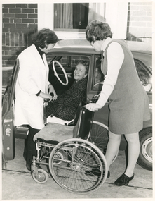
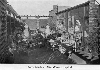 Royal District Nursing Service (now known as Bolton Clarke)
Photograph - Digital Image, c.1935
This digital image shows the sun roof on the Melbourne District Nursing Society After-Care Hospital, 45 Victoria Parade, Collingwood. It shows some of the children nursed at the home. Many children were nursed there long term during the Poliomyelitis epidemic in the 1930s. It also shows uniforms worn by nurses and Sisters in the 1930s. The Melbourne District Nursing Society After-Care Home was originally established to provide nurse-managed convalescent care to poor and underprivileged patients who could not look after themselves at home due to illness, or on release from hospital. Opening in 1926 following a public appeal for funds, at a cost of £27,000, the Home included maternity, children’s and adult wards as well as accommodation for Matron, twelve Sisters and four domestic staff. Many children were nursed there, some long term, during the Polio epidemic and the Society employed two School Teachers. The Society now ran two divisions, the After-Care with its own Sisters and nurses and the District division. The Society were the first in Melbourne, in early 1928, to recognize some patients leaving the After-Care, and many at home, needed further social care and they set up ‘Almoners’ from their committee to visit these patients and be intermediaries in getting them social assistance. It was late the following year before the first training of Almoners took place in Melbourne. In 1930 the Society employed a full time kindergarten teacher to visit poor children in their homes. That year the Society were pioneers in opening an Ante-Natal Clinic at the After-Care, setting a high standard with equipment, keeping records and providing leaflets with instructions in how to keep healthy during pregnancy, what complications to look for and what to do when labour commenced. In 1934 the Society were pioneers again when they opened the first Women’s Welfare Clinic, including at the time a very controversial Family Planning Clinic, the first of its kind in Australia which was opened to support women at risk following multiple and difficult pregnancies, giving advice on birth-control. At first the clinic was attended by their own patients, but then accepting patients from public hospitals until their own clinics were opened. . Major extensions in 1934 led to the After-Care 'Home' having a name change to 'Hospital'. A trained Almoner was employed in 1934 but she resigned after twelve months due to the work load. Unable to procure another due to a shortage of trained Almoners, a Social Service Officer was employed at the After-Care who successfully gained better housing from the Housing Commission for families living under unsuitable conditions. Following Government intervention, the After-Care Hospital was separated from the Melbourne District Nursing Society in 1957. The After-care Hospital continued to operate at the same address until 1985 when it became the Melbourne Geriatric Centre. This digital Image shows two nurses and two Trained nurses (Sisters) supervising convalescing children in the roof garden of the Melbourne District Nursing Society After-Care Hospital . The two nurses are with the rear children, one on the left and one on the right. Both are wearing long white aprons over their long sleeved dark grey uniforms, and both are wearing white caps over their dark hair. On the right rear, in front of a row of glass windows, the upper portion of a Sister can be seen wearing a white uniform and white veil. In the right front is another Sister who is wearing glasses and is wearing a white uniform and dark coloured cape. She is wearing a white veil over her short dark hair. There are three boys and four girls resting on cane lounges; some are reading books and one girl is holding a doll. Another boy, who is wearing a dressing gown, is sitting on a cane chair. There is a trellis and a wall of windows on the left of the image and some brick work and a wall of windows on the right hand side behind the Sisters.. Some pots with low and tall plants can be seen.A tiled hip roof of a building can be seen in the rear of the image.mdns, melbourne district nursing society, after- care hospital, nurses uniforms -
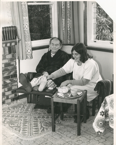 Royal District Nursing Service (now known as Bolton Clarke)
Photograph - Photograph, black and white, Barry Sutton, 24.06.1977
The RDNS Sister is visiting the gentleman in his home and has dressed the wounds on his toe. The dressings applied have been ordered by a Doctor. Under her gown, the Sister is wearing her RDNS winter uniform of a blue/grey skivvie under a tunic style frock made of blue/grey herringbone winter materialFrom its inception in 1885 the Trained nurses (Nurses) of the then named Melbourne District Nursing Society (MDNS), later named Royal District Nursing Service (RDNS) gave high quality nursing care to patients in their own homes. They nursed patients referred by Hospitals and General Practitioners giving treatments, such as injections, wound care. When sterilized dressing trays were used for the first visit, and if applicable, the Sister demonstrated how to sterilize a 'home set up', using the washed forceps from the tray and using a clean cup and plate, making sure there were no chips or cracks, which were to be used to hold lotion and dressings at the time of future visits. They were given written instructions in how to sterilize this equipment in a saucepan on the stove prior to the next RDNS visit. Patients bought their own dressings, if not supplied by a hospital, and the attending Sister demonstrated how to sterilize these in the oven, using a casserole dish as a receptacle. Clear written instructions were left with the patient.Black and white photograph showing a Sister from the Royal District Nursing Service (RDNS), giving specific care to the feet of a gentleman. The RDNS Sister has shoulder length dark hair and is wearing a white gown over her RDNS uniform. The gentleman has balding dark hair and is wearing a dark dressing gown over his pyjamas. He is seated in a recliner chair in his lounge room and has his legs extended with his feet resting on the recliner foot. He has a slipper on his right foot and nothing on his left foot. The Sister is sitting on a stool to the right of him him with equipment, a cup, saucer and forceps and a casserole dish containing dressings, on a tray in front of her on a small square wood and cane stool. She has her right hand on the gentleman's left foot and pieces of dressing material can be seen around three of his toes. There is a patterned rug, under the recliner chair, sitting on top of the carpet. To the left of the chair part of a brick fireplace can be seen. Two windows with open short patterned curtains can be seen in the background. In the right foreground, part of a white and floral tablecloth can be seen hanging over a low table.Photographer stamp. Quote No. DN 86royal district nursing service, rdns patient care, rdns wound care -
 Royal District Nursing Service (now known as Bolton Clarke)
Photograph - Photograph, black and white, Barry Sutton, 12.07.1973
Sister Watt is an RDNS Liaison Officer and has assisted a hospital employee to transfer a patient into a car. The lady will be attended by RDNS District Sisters when she returns to her home.Liaison had occurred between Doctors and the Trained nurses (Nurses) of the Melbourne District Nursing Society (MDNS), from its inception in 1885. This increased when Midwifery was introduced in August 1893 with close liaising with the Women’s Hospital. As District nursing grew it was recognized that closer liaising between many Public Hospitals would be beneficial, for not only the MDNS, later called Royal District Nursing Service (RDNS), Trained nurses (Sisters), but also for the patients and the hospitals. In August 1964 a Liaison Officer commenced at the Alfred Hospital. This soon increased to Liaison Officers working full time at several Public Hospitals. They facilitated the smooth transition from hospital to home for many patients who required ongoing nursing care. Liaison Sisters regularly attended discharge planning meetings, interviewed prospective patients, co-ordinated discharge and booked the first visit by the visiting RDNS Sister. At the time of a patient’s discharge, the Liaison Sister forwarded information on their diagnosis and instructions regarding the care required at home to the appropriate RDNS Centre, and in turn the attending District Sister wrote a report of progress and any queries to the Hospital Doctor, via the Liaison Sister, at the time the patient was attending outpatients. Any new instructions were then sent back to the District Sister. Liaising also occurred between District Sisters and Doctors when patients were referred by General Practitioners and did not attend a hospital.On the left of this black and white photograph is the side-on view of a lady who has short curled hair and is wearing a white hospital coat over a dark skivvie and dark slacks. She is standing against the inside of the open passenger door of a grey car and is holding the removed arm of a wheelchair in her hands. She is looking down at a lady who is sitting in the passenger seat of the car. The lady, who has short curly dark hair, has her head turned to her left and is smiling. She is wearing a grey and black patterned frock. A wheelchair is in front of the opening of the door with the seat, which has a sheepskin on it, close to the car seat and the back of the chair to its right. Sister Helen Watt of the Royal District Nursing Service (RDNS) is standing side-on behind the chair and is holding its handles; her legs are placed between its large wheels. Sr. Watt has curled dark hair and is wearing a light grey skivvie over a darker grey V neck tunic style frock. Only a small section of her face can be seen; she is smiling and looking down at the lady. In the background, part of a brick building with a white framed, open curtained window can be seen. Barry Sutton LO 34royal district nursing service, rdns, rdns liaison, sister helen watt -
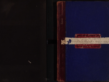 Federation University Historical Collection
Book - Documents, Herbert Henry Smith, Ballarat Technical Art School, 1918-1929, 1918-1929
Blue hard covered book with hand written reports from the Art Principal, H.H. Principal. Two letters are pasted into the front, one from Frank Tate of the Victorian Education Department. 26 April 1918 - Proposed pottery industry in Ballarat 31 May 1919 - Erection of pottery kiln, with Selkirk bricks. 28 June 1918 - Daylesford Technical Art School. 30 August 1918 - Resignation of C. Campbell, instructor of Photography. 25 October 1918 - Returned Soldiers Classes in Art Metal and Signwriting. 25 October 1918 - Herald Shield Trophy 28 July 1922 - Ragged Boys Home, Tennis Court 22 August 1924 - Letterhead of the Attorney General Victoria concerning the transfer of the Ballarat Supreme Court to the Ballarat School of Mines. 15 October 1924 and 20 May 1925 - Carvings of 24 panels decorated with Australian birds, animals and flora to form part of the decoratve scheme for the Villers Bretonneux school. 21 April 1926 - White Flat is available for the use of the school. 29 February 1928 - Donation of a linotype machine by The Courier. 27 June 1928 - Internal Sewerage to the Ballarat Technical Art Schoolballarat school of mines, ballarat technical art school, h.h. smith, returned soldier teachers, harold herbert, ponsonby carew-smyth, f.h. hoskin, carpentry workshop, donald i. johnston, herald shield, kenneth moss, hilda wardle, miss bell, margaret bell, millinery, j.y. mcdonald soldiers memorial, john rowell, repatriation building, stained glass classes, dressmaking fees, ballarat supreme court, m. baird, carvings, villers bretonneux school carvings, ethel kift, m.c. young, macrobertson scholarship, elvie ford, edwin robinson, annie hauser, robina mackie, e. quick, tennis court, w.e. gower, colin hunt, white flat, frank hall, effie holmes, mavis beacham, henry harvey, plaster casts, pearl frickie, w.r. dean, marjery henderson, sewerage, laura crouch, ballarat teachers' college, gertie gough, gwen nagle, lynda clark, jack walker, cyril gibbs, repatriation, donald johnston, ceramics, kiln, c. campbell, photography, jean maude, sylvia copperwaite, olga dulfer, may pollock, margaret bailey, stella clarkson, may norrie, nellie nicholls, nancy govan, edith curnow, kathleen windsor, betty johnson, edna pearson, elvie thege, gwen neagle, effie george, gwen tunbridge -
Bendigo Historical Society Inc.
Document - John Beebe's Observatory Bendigo, Peter Anderson's article 2020
John Beebe was born in Sandhurst (Bendigo) in 1866. In his earlier years, John and his brother William operated a stonemason's business in Bendigo, designing and making monuments. John graduated as an architect in 1900 . By 1910, John was in sole practice in Bendigo, when he was appointed as architect for the Anglican Diocese. His churches from this period St. Paul's bluestone church in Axedale and St. John's in North Bendigo. He moved to Brisbane in 1916, possibly for health reasons. He died on 15 December 1936 and is buried in the Lutwyche cemetery in Brisbane in an unmarked grave. Lutwyche Cemetery Kedron, Brisbane City, Queensland, Australia Plot MONUMENTAL-COE3-25A-21 https://www.findagrave.com/memorial/239489809/john-beebe Four page collection of research on the observatory built by John Beebe at his residence at 55 Condon Street, Kennington. Articles are: one page brief biography "John Beebe's Observatory in Condon Street'; includes mention of how he acquired the telescope that was built into the brick observatory at Condon Street. "the building is a very rare survivor and an important relic of late 19 century scientific endeavour in Bendigo and should be placed on the Victorian Heritage Register'. Second article: two pages 'John Beebe, Architect, owner of East Bendigo Observatory. His later life in Queensland 1916 - 1936, by Peter Anderson April 2020. Article includes family history; John Beebe earlier life' John's brother William and his son Wilfred John Beebe; John's career in Bendigo; Astronomy in Bendigo; Fellowship of the Royal Astronomical Society and the move to Brisbane, Queensland and speculation upon the reasons. Third article: 'Our heritage in danger - amazing observatory comes to light' by Mike Butcher. Article addresses the significance of Beebe's observatory building ' and is representative of the city's early endeavours into scientific research'. At end of article a colour photo of the observatory with the heading 'John Beebe's observatory in Condon Street under threat of demolition'. john beebe, william beebe, observatory, 55 condon street kennington, stonemason, architect, st. pauls axedale, st. john's north bendigo, heritage significance -
 Eltham District Historical Society Inc
Photograph - Digital Photograph, Marguerite Marshall, Souter House, 23 Falkiner Street, Eltham, 20 June 2008
Originally built in the 1850s by Charles Souter from earth excavated from his property. It was a forerunner for a building style that was later to be synonymous with Eltham. The house is historically significant as the oldest mud brick building in the Shire of Nillumbik, as one of less than half a dozen buildings from the 1850s that survive in the Shire. It underwent several additions and alterations between c.1950s-1980s. It is also significant for its associations with Mervyn Skipper from the well-known Eltham family who was one of the founders of the artist's colony at Montsalvat. The house is architecturally significant because its north section was designed by the noted 'Eltham-style' architect, Alistair Knox, and the two long Oregon beams supporting the main floor were added by the noted 'Eltham-style' builder, Horrie Judd who built the southern room. A onetime tenant in the house, Judd built many Eltham houses and was a major builder of Montsalvat. The 1934 flood destroyed the south wall and the house remained unoccupied for some time. Sonia Skipper, one of Montsalvat’s builders who also worked for Alistair Knox oversaw rebuilding it. She employed landscape designer Gordon Ford, artist Peter Glass and Tim Burstall. The house originally had a cellar for making and storing wine, reputedly the first made in the district according to Alistair Knox in his book ‘We are what we stand on’ (p33). Water would seep into the cellar so Sonia’s father and then owner of the house, Mervyn Skipper bulldozed a channel outside to divert it. The Brocksopp family purchased the house in 1950 and added an outside door to the cellar and converted it into a gallery. Covered under Heritage Overlay, Nillumbik Planning Scheme. Published: Nillumbik Now and Then / Marguerite Marshall 2008; photographs Alan King with Marguerite Marshall.; p51This collection of almost 130 photos about places and people within the Shire of Nillumbik, an urban and rural municipality in Melbourne's north, contributes to an understanding of the history of the Shire. Published in 2008 immediately prior to the Black Saturday bushfires of February 7, 2009, it documents sites that were impacted, and in some cases destroyed by the fires. It includes photographs taken especially for the publication, creating a unique time capsule representing the Shire in the early 21st century. It remains the most recent comprehenesive publication devoted to the Shire's history connecting local residents to the past. nillumbik now and then (marshall-king) collection, eltham, falkiner street, mud brick building, mudbrick houses, souter house -
 Eltham District Historical Society Inc
Photograph - Colour Print, Harry Gilham, Eltham Roll of Honour, Eltham War Memorial Hall, Nov 2004
The Eltham Roll of Honour Board was originally commissioned and paid for by the Eltham War Memorial Trust from funds raised by public donation. It was originally hung in the Infant Welfare Centre. In 1999 the Honour Roll Board was removed from the Eltham War Memorial by members of the RSL and relocated to the Eltham RSL sub-branch on Main Road. Following financial collapse of the Eltham RSL sub-branch and merger of the Eltham and Montmorency sub-branches and subsequent sale of the Eltham property, the WW1 obelisk was relocated to a location in front of the Eltham War Memorial. The Honour Roll Board was retrieved by former Eltham District Historical Society President, Harry Gilham in September 2004 who arranged for it to be re-hung in the Eltham War Memorial Hall (former Children's Library) where it was attached to the brick wall face of the west (rear) wall of the Hall (as seen in this photograph). Sometime around late 2018 when Council was investigating the potential sale and development of the Eltham War Memorial, the Eltham Honour Roll Board was once again removed from the Eltham War Memorial by persons unknown, under the pretext of ‘safekeeping,’ to a location outside of the Shire of Nillumbik, in the City of Banyule. In early 2021 Eltham District Historical Society was made aware of the removal of the Honour Roll Board. A formal request was made by EDHS to return this community asset to its rightful place as intended when it was commissioned and paid for by the Eltham War Memorial Trust. This request was rebutted. Nillumbik Shire Council has also since been made aware of the removal of this community asset and formally requested its return prior to Anzac Day, 2021 where it can once again be made accessible to members of the community to pay their respects as originally intended. As of July 2022, the Honour Board remains missing from its rightful place at the Eltham War Memorial. eltham war memorial hall, honour board, honour roll, roll of honour -
 Eltham District Historical Society Inc
Photograph - Digital Photograph, Marguerite Marshall, Jelbart Barn, 93 Arthur Street, Eltham, 11 November 2006
Situated at the top of the hill in Arthur Street, the former Jelbart residence and barn were part of a major change that transformed Eltham's character in the late 1960s. Built from the mid 1940s through mid 1950s when Eltham was a rural community, the Jelbrat residence and barn are all that remain of a family property of some 250 acres (100 ha). With growing population pressures, in the late 1960s, owners Ron and Yvonne Jelbart decided to subdivide their property creating the Woodridge Estate in the early 1970s, a major factor towards the transformation of Eltham to the suburb it is today. The Jelbarts had moved to Eltham in the early 1940s when they purchased a poultry farm in New Street, now Lavendar Park Road. (The local Black Friday bushire of January 13, 1939 had started at C.A. (Clarrie) Hurst’s Eltham Poultry Farm and Hatchery in New Street.) Jelbart was primarily a businessman importing office machinery but desired farm beef and dairy cattle so the couple purchased the virgin bushland at what was then at the end of a dirt road, Arthur Street. With post war shortages of most building materials, they followed the example of the Eltham Artists' Colony (later called Montsalvat) and built thier home from mud-bricks and recyclked materials. The barn was first to be completed in 1945 which they made their home whilst building the main residence. It took eight years to complete the two buildings. Both the main residence and the barn are now separate homes, and along with the remaining property being sub-divided further in 1998 are now part of the Kinloch Gardens Estate at 93 Arthur Street. Covered under Heritage Overlay, Nillumbik Planning Scheme. Published: Nillumbik Now and Then / Marguerite Marshall 2008; photographs Alan King with Marguerite Marshall.; p139This collection of almost 130 photos about places and people within the Shire of Nillumbik, an urban and rural municipality in Melbourne's north, contributes to an understanding of the history of the Shire. Published in 2008 immediately prior to the Black Saturday bushfires of February 7, 2009, it documents sites that were impacted, and in some cases destroyed by the fires. It includes photographs taken especially for the publication, creating a unique time capsule representing the Shire in the early 21st century. It remains the most recent comprehenesive publication devoted to the Shire's history connecting local residents to the past. nillumbik now and then (marshall-king) collection, eltham, arthur street, jelbart barn, jelbart home, kinloch gardens -
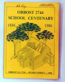 Orbost & District Historical Society
book, Orbost 2744 School Centenary 1886 1986, 1986
2228.1 belonged to Ruth Legge. 2228.2 belonged to Mary Gilbert. This book was produced as a souvenir history of Orbost Primary School. The Orbost State School opened on 19th of March 1886 .The school had first operated temporarily in a leased building, and on a half-time basis with SS2745 Jarrahmond. The first head teacher was HT Campbell Mackay. However he remained in charge only until 12th of May 1886. The second HT, John Rowe, served until 1908. On 30th of June 1887, a portable room was provided; it being brought to the area by schooner. The school then had accommodation for 30 pupils; the teacher's welfare was considered because quarters of two rooms were attached. As the population increased so did the needs of the school. This was reflected in the provision of a larger classroom in 1898. During 1910-11 the first approaches were made to the Department for the establishment of a HES in Orbost and this became a reality in 1912. Orbost HES supplied post-primary education in the district until a high school was built in 1948. When fire destroyed the school in 1941 local halls were used as classrooms until a new school was built. Work was quite rapid and a new brick structure was opened by the Hon. A. E. Lind, MLA, on 13th of February 1942. The head teacher then was Leslie Collins. Orbost continued to develop and the new school was soon overtaxed. This resulted in the erection of two Bristol classrooms in 1947. By 1950, when the school population had reached 500 pupils the opening of the new school at Orbost North was welcomed by all concerned. In 1963 the Department purchased land diagonally opposite the school and developed it as a playing area. In 1965 two LTCs were opened in November, and in October 1968 the Brodribb School building was moved to SS2744 Orbost for use as a general purpose room. This book is a useful research resource.Two copies of a yellow paper book book. On the front cover is a sketch of some trees beneath the title which is in green print ( these are the school colours) . This is a souvenir record of the history of Orbost Primary School.2228.1 has autographs on the back fly.orbost-primary-school book orbost-history -
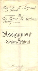 Federation University Historical Collection
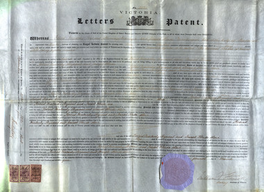
Document, Indenture Between Robert M. Serjeant, Joseph Flude and the Trustees of the Ballarat School of Mines regarding Letters of Patents for the Benefit of the Ballarat School of Mines, 1877, 04/03/1875
R.M. Serjeant was listed as a mining manager and Joseph Flude as a metallurgist. In 1875 they were both living in Ballarat. The patent number is A.D.1875, 4th March. No 2031. According to the patent the hearth of the furnace is in the form of a cone revolving horizontally. The feed is supplied to the apex of the cone by an archimedian screw. The crown of the furnace comprises a double covering or roof with an intermediate chamber for receiving heated air. The inner covering is pierced to admit of the heated air being brought into contact with the pyrites on the face of the revolving hearth. The discharge of the roasted substance is affected by means of a scraper at the base of the cone. It was claimed that this was a new mode of introducing heated air, and the exclusion of flame during the operation of roasting pyrites. The self-acting charge and discharge of the furnace and the peculiar construction of the hot air chambers, and the use of perforated bricks through which the supply of air is affected were also new. (http://patentsvictoria.net/002031.html) From the Goulburn Herald, 14 September 1878 "A feature connected with the school of mines is the yet unfinished pyrites works. The extraction of the gold from pyrites and the utilization for commercial purposes of other substances connected with pyrites are peculiarly important to Ballarat, because were a simple and inexpensive method devised there are millions and millions of tons of quartz that would then be made remunerative. With this thought in their minds two scientific gentlemen invented the school of mines self-acting rotatory furnace. This, for lack of funds, has not been completed as yet, but the amount in hand for the purpose is daily increasing, and it will eventually be an accomplished fact. It is in contemplation also to erect machinery shops in connection with the school, and it is purposed to con struct a steam-engine to do at once the work of the pyrites treatment and the ma chine room. A model shaft and mine too are being prepared for on the reserve, so that practical mining of the most thorough character may be taught on the ground.'Large indenture on red bordered vellum. The indenture was regarding a patent for the benefit of the Ballarat School of Mines. Letters Patent for an Invention for Roasting Pyrites to be called 'the Ballarat School of Mines self-Acting Pyrites Furnace" to Robery Malachy Serjeant and Joseph Flude. The large document is on a vellum type paper complete with stamps and seal. The document is signed by Acting-Governor William Stawell. Inscriptions and Markings Written on verso: "Date of Patent 4th March 1875 No 2031 Letters Patent for An invention for roasting pyrities to be called "The Ballarat School of Mines Self-acting Pyrities Furnace" to Robert Malachy Serjeant and Joseph Flude Melbourne, Victoriaballarat school of mines, serjeant, r.m. serjeant, robert m. serjeant, flude, joseph flude, patent, barry, redmond barry, rogers, judge rogers, bland, rivett henry bland, john airy, warrington rogers, establishment, indenture, legal, cuthbert, ballarat school of mines trustees, william stawell, john warrington rogers -
 Federation University Historical Collection
Document, Letters Patent for an Invention for Roasting Pyrites, 1875, 1875
R.M. Serjeant was listed as a mining manager and Joseph Flude as a metallurgist. In 1875 they were both living in Ballarat. The patent number is A.D.1875, 4th March. No 2031. According to the patent the hearth of the furnace is in the form of a cone revolving horizontally. The feed is supplied to the apex of the cone by an archimedian screw. The crown of the furnace comprises a double covering or roof with an intermediate chamber for receiving heated air. The inner covering is pierced to admit of the heated air being brought into contact with the pyrites on the face of the revolving hearth. The discharge of the roasted substance is affected by means of a scraper at the base of the cone. It was claimed that this was a new mode of introducing heated air, and the exclusion of flame during the operation of roasting pyrites. The self-acting charge and discharge of the furnace and the peculiar construction of the hot air chambers, and the use of perforated bricks through which the supply of air is affected were also new. (http://patentsvictoria.net/002031.html) From the Goulburn Herald, 14 September 1878 "A feature connected with the school of mines is the yet unfinished pyrites works. The extraction of the gold from pyrites and the utilization for commercial purposes of other substances connected with pyrites are peculiarly important to Ballarat, because were a simple and inexpensive method devised there are millions and millions of tons of quartz that would then be made remunerative. With this thought in their minds two scientific gentlemen invented the school of mines self-acting rotatory furnace. This, for lack of funds, has not been completed as yet, but the amount in hand for the purpose is daily increasing, and it will eventually be an accomplished fact. It is in contemplation also to erect machinery shops in connection with the school, and it is purposed to con struct a steam-engine to do at once the work of the pyrites treatment and the ma chine room. A model shaft and mine too are being prepared for on the reserve, so that practical mining of the most thorough character may be taught on the ground.'Letters Patent for an Invention for Roasting Pyrites to be called 'the Ballarat School of Mines Self-Acting Pyrites Furnace' to Robert Malachy Serjeant and Joseph Flude. The large document is on a vellum type paper complete with stamps and seal. The document is signed by Acting-Governor William Stawell.Written on verso: "Date of Patent 4th March 1875 No 2031 Letters Patent for An invention for roasting pyrities to be called "The Ballarat School of Mines Self-acting Pyrities Furnace" to Robert Malachy Serjeant and Joseph Flude Melbourne, Victoriaballarat school of mines, serjeant, r.m. serjeant, robert m. serjeant, flude, joseph flude, richard gibbs, stawell, william stawell, pyrities furnace, philately, statute stamp, seal (victoria), ballarat school of mines self-acting pyrities furnace, ballarat school of mines self-acting pyrites furnace -
 Federation University Historical Collection
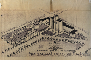
Plan, Ballarat School of Mines Future Development: A Southern Terminal to Lydiard Street, 1947, 09/12/1947
In 1947 Percy Everett, Chief Architect for the Victorian Government, drew up plans to accomodate the growth in student numbers on the Ballarat School of Mines site. It was an era of government buildings surrounding the Ballarat School of Mines campus either being transfered to the school or foreshadowed for transfer. In 1947 two Red Cross huts were transferred from Victoria Park to the western side of the former Ballarat Supreme Court (later Courthouse Theatre) for use by Wool Classing and Motor Mechanics. In the same year additional facilities were provided for Pottery due to the increase in enrolments and a large brick classroom was built at the rear of the Ballarat Junior Technical School Building. In the annual report of 1947 the President said: "These transfers are, however, only temporary expedients and indicate the pressing need for more buildings of a permanent nature". By the end of the year the School Council decided to request the Education Department of Victoria to proceed with the implementation of the School's long-range plan whch had received approval earlier and to treat it as an urgent post-war requirement. After much communication a plan for a six-storied building, flanked by two three storied buildings was planned to be built on the site of the Ballarat Gaol was developed. The plan was sent to the Education Department for the Minister's Approval. It is not know if approval was granted, but the building did not proceed, possibly becausse the Ballarat Gaol was still very miuch in use. When a tertiary division of the Ballarat School of Mines was being developed in 1967 it corresponded with the closure of the Ballarat Gaol. It was determined that the Lydiard Street South site had no room for future growth so a new campus was sought. The new campus was purchased at Mt Helen, and was initially known as the Ballarat Insittute of Advanced Education. In 1976, when the Ballarat Teachers' College merged into the structure, the campus became known as the Ballarat College of Advanced Education and it was no longer a part of the Ballarat School of Mines. Plans for a proposed building to replace the Ballarat Gaol buildings. The proposed building was never built, the concept being replaced by a new teritary facility at Mt Helen. buildings, percy everett, ballarat school of mines battery, ballarat technical art school, engineering workshops, machine shop, ballarat junior technical school, architectural plans, ballarat school of mines, smb campus -
 Westbourne Grammar Heritage Collection
Photograph - Mabel Molland at Monomeith 1962
This reproduction photograph was donated at a major reunion in 2008, organised by students of the school from the 1950s. It pictures Mabel Molland and a young student at Monomeith, home to the school since 1956. Monomeith is a Victorian Heritage Register listed (VHR number H0452), italianate styled brick villa, built in 1887 for one of Williamstown’s most important identities, James Styles. Styles’ distinguished career in public life included membership of the Williamstown Council, a stint in state parliament as the Member for Williamstown (1894-1900) and, in 1901, election to the first commonwealth parliament as a senator. During the 1890s he was also a commissioner of both the Melbourne Harbour Trust and the Melbourne and Metropolitan Board of Works and one of the trustees of the Williamstown Grammar School. The property comprises the residence designed by W Bennett Hall and built by James Styles in 1887 and the former migrant hostel buildings (now administration and classrooms), erected around 1951 by the then owner the Melbourne Harbour Trust, and intended to house migrant workers during the dredging of Port Phillip Bay. By the 1950s, the School had outgrown its home at Holy Trinity Hall and Mabel Molland reached out to Mr. Keith White, president of the Parent's Association and well-respected member of Williamstown Council for assistance. In 1956, following lengthy negotiations led by Mr. White, Monomeith was leased from the Melbourne Harbour Trust under a seven-year lease, which eventuated as a twenty-one year lease, followed by purchase of the property in 1972. Since then this historic building has come to be a much-loved symbol of the history of Westbourne Grammar School. This is a rare image of Mabel Molland at Monomeith, taken in the year prior to her retirement having taken over the school in 1914 and then set it on a path for the future as an incorporated company in the hands of a school council, with Mr Keith White as president, in 1956. Black and white reproduction photograph of a a residence (Monomeith) with steps in the middle ground, leading up to a verandah with ornate ironwork. Mabel Molland stands on the steps and a young student can be seen on the verandah. -
Old Colonists' Association of Ballarat Inc.
F.J. Williams' Home, Charles Anderson Grove
The Old Colonists' Association Ballarat Inc. is a not for profit charitable organisation providing accommodation for elderly people. It manages a 27 Home retirement village at Charles Anderson Grove Ballarat. Accommodation is offered at significantly below market rates. It has been providing low cost accommodation to the elderly since the 1920s. The Association Council overseas the running of this facility on a voluntary basis. "GIFT COTTAGES.- Ballarat Old Colonists Benefit BALLARAT.— High tribute to the good citizenship of Mr. and Mrs. F. J. Williams, now of Melbourne, and Mr. S. Clark, of Ballarat. was paid by a representative gathering at Gillies-street on Thursday afternoon, when the two cottages respectively presented by them for the use of old and indigent colonists were handed over to the council of the Ballarat Old Colonists' Association. The cottages are handsome brick structures, modern in design and equipment, and cost about £650 each. Mr. A. H. Nevett, president of the Ballarat organisation, expressed the gratification of the association at the commencement of a scheme of cottages for old colonists, which had been the aim of the association for many years. Mr. Williams said that when in Ballarat he had been in many public movements as President of South-street and president of the amalgamtion (sic) movement, but in giving this cottage for the use of the old people he had established a tangible and definite link between himself and Ballarat. Similar sentiments were expressed by Mr. Clark, who said his benefaction had given him a great and genuine pleasure. Both donors were warmly thanked on be half of citizens generally by the mayor (Cr. A. E. Nicholson). At subsequent social gathering appropriate toasts were honored, and assurances were given that the association's scheme for 50 gift cottages on the lines of Melbourne would be furthered by several in the not far distant future. (The Age, 30 October 1925.)ballarat old colonists' club, old colonists' association, s. clark, f.j. williams, charles anderson grove, philanthropy -
 City of Greater Bendigo - Civic Collection
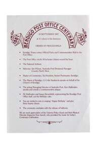
Souvenir - Bendigo Post Office Centenary Ephemera, Ted Rankins, 1987
When the Commonwealth Post and Telegraph Act was passed in June 1902, and a national Postmaster General's Department (the PMG) was established the responsibility the nation's mail and telephone services fell on local Post Offices. The Bendigo Post Office was designed by Public Works architect George W Watson and constructed between 1883 and 1887. The two story brick structure with basement has unpainted rendered facades and a 43m high clock tower complete with 6 bell carillon. The facades are elaborately decorated with Corinthian pilasters, balustrading, lions' heads and the state mansard roof with cast iron ridging and finials. (VHR #4739). Situated on Pall Mall it has always been called the Bendigo Post Office even though it was not until 1891 that the name Bendigo was given to the town. The Bendigo Post Office housed much more than just postal services and the building contained many early government departments and services needed for a growing district. The building celebrated its centenary on the 30th September 1987 to much fan fare with Ted Rankins, the then Postal Manager planning many of the week long events including tours of the post office, a grand parade with cake and staff in period costume, a ball at the Shamrock and a barbeque in Rosalind Park. The Post Office ceased providing postal services in 1997 after the privitisation Australia Post and Telstra but continues to play a central role for the community, providing important services to visitors and locals alike. Currently it is occupied by Bendigo Tourism and includes two exhibition spaces including the Living Arts Space and Djaa Djuwima a dedicated and permanent First Nations Gallery. Activities at the Post Office are supported by City of Greater Bendigo staff and a dedicated group of volunteers. These items are part of the postal collection donated by the Rankins family in memory of the last postal manager at the Bendigo Post Office, Ted Rankins. 0364.1: Single sided printed 'Order of Proceedings' flyer; Outlines the running of events for the celebrations on Wednesday 30 September, 1987 at the Post Office with the centenary logo centre top in crimson ink. 0364.2: Single sided, four-colour printed, DL size invitation for celebrations marking the centenary of the Post Office on Wednesday 30 September, 1987. 0364.3,.4,.5,.6,.7: Printed cake bag with centenary logo and image of Bendigo Post Office printed on front in crimson ink. 0364.8,.9,.10,.11: Square note paper with centenary logo and border printed in crimson ink. 0364.12 Envelope: Australia Post envelope with Bendigo 100th anniversary images. Date stamped and addressed to Mr Edmondston Postmaster, Elmore. bendigo post office, bendigo tourism, city of greater bendigo tourism, post office collection, ted rankins collection, city of greater bendigo volunteers -
 Wodonga & District Historical Society Inc
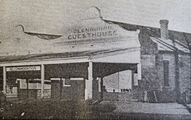
Photograph - Glenburnie Guest House, Wodonga
In the early 1900s a new Coffee Palace was erected on the first railway land to be leased for private business in Wodonga. This Coffee Palace (later to become Glenburnie Guest House) was situated in High Street opposite the former Customs House which at the time was being used as the Wodonga Police Station. It was built by Mr Denny Donovan and operated by his wife. An article in the Wodonga and Towong Sentinel declared that “No expense has been spared in the erection and fitting up of the Palace, which is intended to supply a long felt want”. The building consists entirely of brick and the rooms are lofty, spacious and well-ventilated. The bedsteads are modern, and will satisfy the most fastidious. The motto of the proprietress is “Cleanliness, civility and attention”. Mr Donovan died in January 1908 and in 1909 the Wodonga Coffee Palace was sold by Mrs Donovan to Mrs P. Egan who advertised hot and cold shower baths with meals at all hours. In 1913 the Wodonga Coffee Palace was taken over by Mrs Cuthbertson and Miss Steele. In 1921 Wodonga Coffee Palace was taken over by Julia Ronan who had successfully conducted the dining rooms at the Wodonga Saleyards for 15 years until those premises burned down. The Wodonga and Towong Sentinel on 10 January 1936 reported that “the business premises formerly conducted by Mrs Ronan have been renovated and refurbished. The new proprietresses are Misses Breen, who have had extensive experience in managing such businesses. The new premises will be known as the Glenburnie Guest House.” Changes of ownership continued with Mrs M.E. Elliot taking over in December 1940, followed by Mrs Stella Victoria Wong in 1945. In 1953 it was again taken over by Mrs E.M. Moran. The date of the closure of Glenburnie Guest House is uncertain but the building was demolished in the early 1970s.This image is significant because it is one of the few remaining links to an important Wodonga business.A photo taken from a newspaper article about Glenburnie Guest Houseglenburnie guest house, early wodonga businesses, coffee palaces -
 Eltham District Historical Society Inc
Book, Flavour of Eltham : recipes and other items collected by friends of the Shillinglaw Cottage, 1964
Flavour of Eltham: recipes and other things was collected and published by the Friends of Shillinglaw Cottage in 1964. The original cottage once stood about 100 metres away from its current location in Panther Place, Eltham. Built in the 1870’s, it is one of Eltham’s earliest buildings. In 1963 it faced demolition to make room for the Eltham Shire offices. But local residents came together to save the cottage. It was the first time that an early settler’s brick building was removed and reconstructed. A fundraiser was the resident’s compilation of loved recipes into the cookery book Flavour of Eltham. It also includes illustrations and advertisements for local buisnesses. The foreword of the book states: “This book is about Eltham. But more than that it is about intention. It originated when the people of Eltham, the first in Australia to preserve the reconstruction an historical building, removed and rebuilt a cottage that reflected the spirit of a period. The shilling law cottage was first built in 1859 and was rebuilt in 1964. It has beauty and is rich with the past. The people of Eltham stand for something. There is, in this community, a firm resolve to preserve for their children the natural beauty of the district; to establish a centre whose allegiance is to aesthetic values rather than to commercial ones. Eltham already has this reputation, a reputation that is known beyond the borders of Australia. Its desire is to increase it. This book is a step forward in that direction.” October 1964. Signed Alan Marshall The chapters include: Old time, Restaurants, are you in a hurry, Advance action, Serve it cold, Tea time tanstalizer, Pickles and preserves, Fabulous fare and Ne Buvez Jamais L’eau. The cover illustration was drawn by Peter Glass, First Edition: November 1964, Second Edition: January 1965, Third Edition: August 1965, Fourth Edition: August 1968 Additonal souce: Marshall, Marguerite, Nillumbik Now and Then, MPrint Publications, 2008Paperback; 116 p. : ill. ; 18 x 23 cm.shillinglaw cottage, cooking, recipes, cookery, friends of shillinglaw cottage