Showing 513 items
matching black forest
-
 Whitehorse Historical Society Inc.
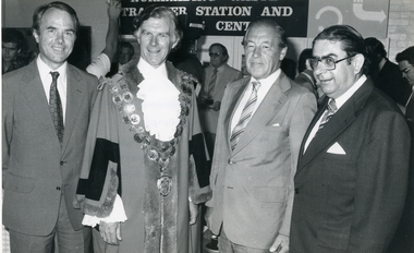
Photograph, State Cabinet Meeting - City of Nunawading, 9/02/1981 12:00:00 AM
Black and white photograph of attendees at the State Cabinet Meeting held at City of Nunawading on 9th February 1981.|L - R: Don McKinnon, MLA, Member of Box Hill| The Mayor - Cr W.B. Renfrey| The Premier - The Hon. R.T. Hamer, ED, MP| John Richardson, MLA, Member for Forest Hillvictoria. state cabinet, mckinnon, don, renfrey, will b., hamer, rupert j. sir, richardson, john -
 Whitehorse Historical Society Inc.
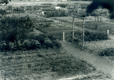
Photograph, Nunawading Community Garden
Black and white photograph of the Nunawading Community Garden in Jolimont Road, Forest Hill established in October 1977. This photo would have been taken 1977-78community gardens, city of nunawading, nunawading community garden, parks and reserves -
 Whitehorse Historical Society Inc.
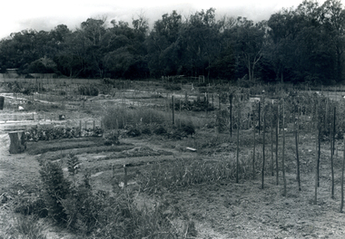
Photograph, Nunawading Community Garden
Black and white photograph of the Nunawading Community Gardens in Jolimont Road, Forest Hill established in October 1977. this photo would have been taken in 1977-78community gardens, city of nunawading, nunawading community garden, parks and reserves -
 Whitehorse Historical Society Inc.
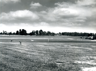
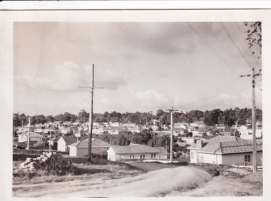
Photograph, Mahoney Reserve, 1972
Black and white photograph taken south from Vicki Street in 1972 of Mahoney's Reserve, Forest Hillmahoneys reserve, sportsgrounds -
 Whitehorse Historical Society Inc.
Photograph, 13 Marong Terrace Forest Hill, 1954 to 1958
Eight black and white photographs showing the development of the house at 13 Marong Tce Forest Hill 1956 to 1958.Dates on back of photographsmarong terrace forest hill forest hill -
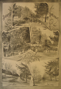
 Ballarat Heritage Services
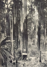
Image, Typical Mountain Ash Forest, c1934
... Office goldfields forest woodcutter mountain ash Black and white ...Black and white image of a woodcutter in a Mountain Ash Forest, Victoria. The trees attained a height exceeding 91 metres (300 feet). forest, woodcutter, mountain ash -
 Ballarat Heritage Services
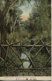
Postcard, Ballarat Botanical Gardens, c1908
"Within six years of its first land sales in 1852, founder members had challenged council over horticultural decisions and Ballarat's main thoroughfare contained fences squares, trees and flower beds. The major works that projected the Garden City image were the street plantings, parks and botanical gardens ..." Reference: Michael Taffe, Growing a garden City: Ballarat Horticultural Society 1859-2009, BHS Publishing, 2014, p. 10.This postcard shows how the botanical gardens in Ballarat, famous for being a Garden City.Coloured postcard Forest Scene, Botanical Gardens, Ballarat printed in red at bottom of card. Elaine 30-11-08 handwritten in black ink underneath.botanical gardens, ballarat, forest scene, gardens, botanical, -
 Ballarat Heritage Services
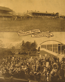
Image - Black and White, Dowling Forest Racecourse, 1922, 1922
... . Dowling Forest Racecourse, 1922 Image - Black and White ...Image of raceday at Dowling Forest.dowling forest, dowling forest racetrack, dowling forest racecourse, horse racing -
 Ballarat Heritage Services
Image - Black and White, Dowling Forest Racecourse, c1910, 1910
... Image of Sturt Street Gardens, Ballarat Dowling Forest ...Image of Sturt Street Gardens, Ballaratsturt street ballarat, sturt street gardens -
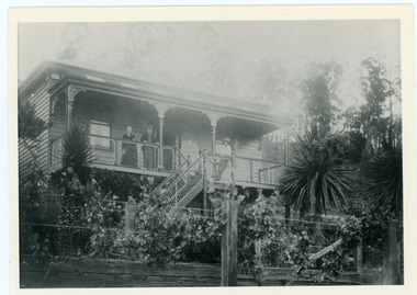 Mt Dandenong & District Historical Society Inc.
Photograph, Home of George and Sarah Barber c1905
George and Sarah Ann Barbers home "Forest Edge' on Barber's Road. Jabez Richardson (father of Sarah Ann) and his wife Sarah jane are standing on the front verandah. An unknown male is also in the picture.Black and white photograph showing four adults standing on the front verandah of a house. Reverse of photograph has handwritten description by John Lundy-Clarke.Jabez and Sarah Jane Richardson on verandah of home of their daughter Sarah Ann (Mrs Barber) 1905. Sarah jane died 1906. Jabez died 1908.forest edge, george barber, sarah ann richardson, sarah ann barber, jabez richardson, sarah jane richardson -
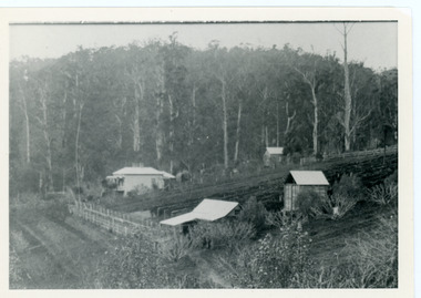 Mt Dandenong & District Historical Society Inc.
Photograph, George Barber's Home Forest Edge after 1912 Looking South West, c1912
George Barber built a homestead later named Forest Edge on Barber's Road and lived there with his wife Sarah Ann (nee Richardson).Black and white photograph showing the side view of a house and three outbuildings. Reverse of photograph has handwritten description by John Lundy-Clarke.George Barber's home on bend of Barber's Road on Lot 25, Village Settlement. Showing passionfruit plantation. Buggy shed top right. Hay shed lower right. Stables, cart shed and men's quarters lower left about 1912. Photo copied by JLC in 1973.forest edge, george barber, sarah ann barber, kalorama, barber's road -
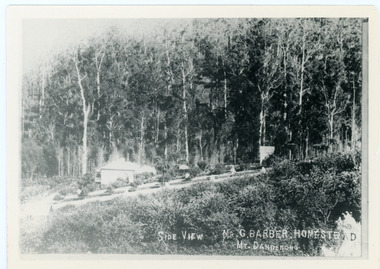 Mt Dandenong & District Historical Society Inc.
Photograph, Side View Mr G. Barber Homestead Mt Dandenong, c1905
Built in 1898 by early settler George Barber the property is still in existence today. It was the home of George, wife Sarah Ann and daughter Ethel.Black and white photograph showing te side view of George Barber's home, later named Forest Edge. c1905. Reverse of photograph has handwritten description by John Lundy-Clarke.Barber's home on Olinda Creek. Lot 25 Sect 1 Village Settlement. Home of George Barber and wife Sarah Ann (nee Richardson). Daughter Ethel.Was bought by Munnerley later Sangster and Kinnear. Later known as Forest Edge. Buggy and wagon shed on right. Photo copied 1973 by JLC. -
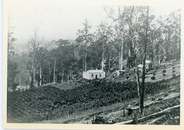
 Mt Dandenong & District Historical Society Inc.
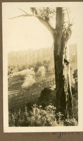
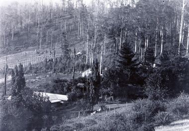
Photograph, View of the Kalorama Valley c1905
John Lundy-Clarke grew up in the Kalorama/Mt Dandenong area and later in life (1972-74) began to write a comprehensive history of the area working from an original settlement map in an effort to cover all areas. This photograph c1905 is looking up from George Barber's house 'Forest Edge' on Barbers Road. 'Forest Edge' was built c1898 and was the home of George Barber and his wife Sarah Ann (nee Richardson). The buildings in the foreground are the stables and hayshed.Black and white photograph showing two small buildings in the foreground with cleared hills behind. Handwritten decription on back by John Lundy-ClarkeA 1905 view of the Kalorama Valley towards the Gap. Barbers stables in foreground with hayshed on left. Tait’s house in centre of picture with Logans in the same fold above the hayshed. “Kalorama” is centre of Gap with Paynter’s “Iona” on its left with stables to its left. It was from one of these trees on the top left that the runaway log was cut that leaped over Barbers Road (at the top edge of the cleared land) then over Logan’s house in one bound in 1930.george barber, sarah ann barber, john lundy-clarke, forest edge -
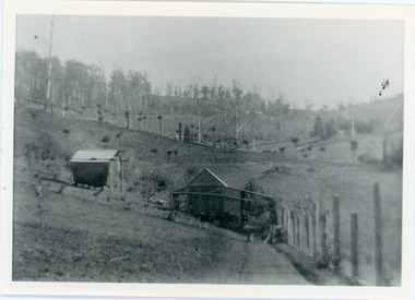
 Mt Dandenong & District Historical Society Inc.
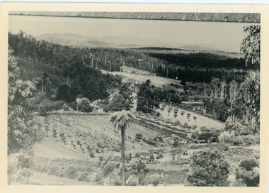
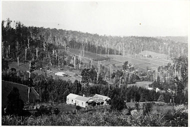
Photograph, Walker's LOT 2
Lot 2 was bought by Harry Walker in the early 1900s. Harry was married to Eva Hand, one of the six daughters of Thomas and Eliza Hand. Harry cleared the land and planted half with raspberries that remained productive until c1928. Harry's son William took over the property. The land was cut in half when the new CRB road went through in the early 1920s. John Lundy-Clarke grew up in the Kalorama/Mt Dandenong area and later in life (1972-74) began to write a comprehensive history of the area working from an original settlement map in an effort to cover all areas.Black and white photograph showing a single storey white house in the centre surrounded by crops. Handwritten description on reverse by John Lundy-Clarke.VIEW 1908 OVER LOT 2 SECTION 1 VILLAGE SETTLEMENT. TAKEN FROM RIDGE ROAD THEN MAIN ROAD FROM HALFWAY BETWEEN MOUNTJOY AND FALLS RD. CRB MAIN RD RUNS BEHIND WALKER’S HOUSE. The house seen in the vista among the tall trees beyond the raspberry patch is “Forest Edge” which was George Barber’s home when the picture was taken. The tall trees to the right of the vista were on Price’s LOT 18 and it was while cutting up one of these for firewood that a length of log weighing about ½ a ton got away downhill and leaped in one bounce over Barbers Road and Logan’s house – 1931.harry walker, william walker, eva hand, crb road, raspberries, kalorama -
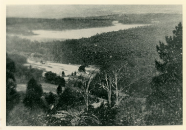 Mt Dandenong & District Historical Society Inc.
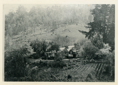
Photograph, Harmony Vale 1933
John Lundy-Clarke grew up in the Kalorama/Mt Dandenong area and later in life (1972-74) began to write a comprehensive history of the area working from an original settlement map in an effort to cover all areas. Harmony Vale was the name of the homestead built by early pioneer Jabez Richardson. The whole of the valley took on this name. The building lasted until 1933. The Silvan Dam was completed in 1932 and was full when this photograph was taken.Black and white photograph looking down over a forested area with a dam in the background. Copied from a Rose Series postcard c1933. Handwritten inscription on reverse by John Lundy-ClarkeRose Series photo of 1933 showing “Harmony Vale” still standing. Copied 1973 JLCharmony vale, silvan dam, jabez richardson -
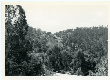 Mt Dandenong & District Historical Society Inc.
Photograph, View From Doughty's Road 1974
John Lundy-Clarke grew up in the Kalorama/Mt Dandenong area and later in life (1972-74) began to write a comprehensive history of the area working from an original settlement map in an effort to cover all areas. This photograph shows approximately the same area as photograph number KAL0193 but is taken 60 years later. The trees have grown much taller and the buildings changed. On the site of the Paynter house 'Iona' there is now the 'Yosemite' (Villa Toscana) accommodation. The pavilion in the centre of the photo is the site of 'Kalorama', home of early pioneer Isaac Jeeves. The photograph is taken looking up towards The Gap (FiveWays).Black and white photograph showing a forested area with clear sites. Roofs of buildings can be clearly seen. Handwritten inscription on reverse by John Lundy-ClarkeView from near Doughty’s Rd looking north up valley to Kalorama Gap in Jan 1973. Tiny roof in centre is pavilion on site of “Kalorama”. Long roof to its left is Yosemite Motel on site of “Iona”.paynter, kalorama, iona, yosemite, villa toscana, five ways, the gap -
 Mt Dandenong & District Historical Society Inc.
Photograph
The photograph is from the album of Ivy May Child. It shows a view across the holding of Walter Jeeves. Walter was the second son of Ellis Jeeves and grandson of Isaac Jeeves, the pioneer. Walter was given the house 'Kalorama' and 20 acres of lnd - most of it sloping. He established a commercial garden, initially growing vegetables but later flowers and shrubs. This land now forms part of Kalorama Park. The building in the photograph is the Kalorama Homestead with shrubs and trees planted in rows on the sloping site. Ivy May Child (1910 – 1989) was the daughter of Arthur Edward (Ted) Child (1878 – 1964) and Ethel May Madden (1888 – 1970). Ted Child was the son of Matthew Francis Child (1839 – 1933) and Martha Jeeves (1857 – 1926). He was the grandson of one of the early pioneers Francis Child. Ivy grew up on the family property on Childs Road and took many photographs. Most of these are glued into her photo album. The album covered the years from c1927 – 1932. Ivy married Henry William Burgess (1906 – 1968) in 1944. The photographs remain in their original state in the album with individual copies made. Black and white photograph with a large gum tree in the foreground, a sloping area of cleared, cultivated land and homestead in the centre and a forested area in the distance.An inscription below the photograph in the album reads: W. JEEVESwalter jeeves, jeeves, kalorama homestead, kalorama park -
 Mt Dandenong & District Historical Society Inc.
Photograph, Harmony Vale, c1913
View of Harmony Vale, the original Kalorama settlement taken from Barbers Road. Child's sawmill can be seen (centre) with the log yard to the right. Richardson's home "Harmony Vale' is in the orchard above the logs.Black and white photograph copied from a Rose Series postcard showing the area known as "Harmony Vale' - the original Kalorama settlement. Child's sawmill is in the centre.Rose Series Photo of Harmony Vale on the Olinda Creek taken from Logans Lot 28. Link Rd crossing centre Shiloah complex left centre. Richardsons (Jeannie’s) “Mt Calvin” between trees above tree fern. Isaac Jeeves house with the tree fern floor among trees against forest right centre. Mill yard with logs above cultivated flat. Mill to left. “Harmony Vale” homestead among orchard above logs. “Glenrivers” in gully at top of clearing. About 1913. Copied JLC 1973harmony vale, harmony vale, child's sawmill, sawmill, barbers road, richardson, shiloah -
 Mt Dandenong & District Historical Society Inc.
Photograph, Home Of Francis Matthew Child, c1910
The homestead of Francis Matthew Child taken from the forest area downstream of Child Bros. Sawmill.Black and white photograph showing the homestead of Francis Matthew Child.This photograph has a detailed inscription on the back handwritten by John Lundy-Clarke.Francis Matthews home on Crown Allotment “E” taken from the forest edge of Harry Child miners lease on which he had his mill. Mill was upstream to the left. The trees in the background were on Hand’s selection “F” and beyond them was the summit of Mt Kalorama.homestead, francis matthew child, sawmill, child's sawmill -
 Mt Dandenong & District Historical Society Inc.
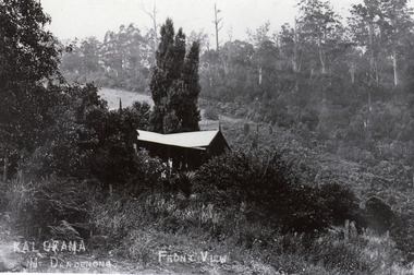
Photograph, Kalorama Guest-house - Front View
Looking down on Kalorama Guest-house from Barbers Road. Property of Ellis and Eliza Jeeves before moving to MountjoyBlack and white photograph with house in foreground and a cleared block and forest in background.KALORAMA Mt Dandenong. FRONT VIEWellis jeeves, jeeves, guest house, kalorama guest-house, barbers road -
 Mt Dandenong & District Historical Society Inc.
Photograph, Kalorama Guest-house with View of Valley
Looking acoss Kalorama Valley. Roof of Kalorama Guest-house, owned by Ellis and Eliza Jeeves, in foreground with two other houses, forest and cleared section. Taken from Barbers Road. Black and white photograph with four buildings visible, cleared crop areas and sparse forest. Washing hangs on a line in the foreground.barbers road, guest house, kalorama guest-house -
 Mt Dandenong & District Historical Society Inc.
Photograph, The Settlement of Harmony Vale 1913, 1913
View of the settlement of Harmony Vale taken in 1913 with the guest house Kia Ora, built by George Barber in 1909, in the foreground. This photograph has a detailed inscription on the back handwritten by John Lundy-Clarke.The settlement of Harmony Vale 1913. The large home in foreground is the Guest House “Kia Ora” owned by George Barber on Lot 25 of the Village Settlement. The house above it to the left was Richardson’s house. The home of Jeanie who had left it when the picture was taken.The buildings furthest to the right of “Kia Ora” were the homestead of Isaac Jeeves of 1863 – 1871 the building furthest right with the black opening in it was the house with the tree fern floor. The flat ground above and left of Isaac’s pointed roof barn is where the creek changed its course in the 1934 flood and destroyed £4000 worth of the Rowse family’s tulip bulbs. Above the flat is Francis Matthew Child’s homestead, in the creek to the right of which can be seen the horizontal structure of the swing bridge to the sawmill of the Childs Bros which cannot be seen but in the forest to the right of the mill (bridge) can be seen a number of logs in the mill yard. The two cleared strips immediately behind Childs home were the Richardson’s original holdings and the house in the gully at the far side of the great clearing is that of the guest house “Glenrivers” belonging to W Lucas and his wife Catherine nee Child. The Richardson homestead “Harmony Vale” is behind the forest trees in the right centre. The picture gives a full view of how the settlement was cut into the centre of the great forest. george barber, kia ora, harmony vale, barber, jeanie richardson, richardson, child, matthew child, kia-ora guest house, guest house, glenrivers -
 8th/13th Victorian Mounted Rifles Regimental Collection
Photograph
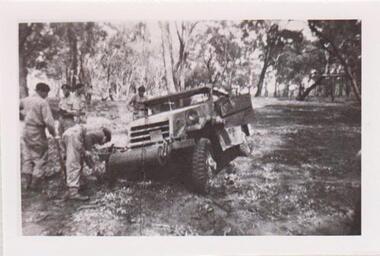
The 8th/13th Victorian Mounted Rifles was raised as a regiment of the Royal Australian Armoured Corps on 1 May 1948 with Headquarters in Melbourne and squadrons in Sale, Benalla/Wangaratta and Albury. In 1955 Regimental Headquarters moved to Wangaratta and a second squadron was located at Albury. The Sale squadron transferred to 4th/19th Prince of Wales’s Light Horse. In 1977 8/13 VMR Regiment was reduced to an independent squadron A Squadron 8th/13th Victorian Mounted Rifles and in 1991 was linked with 4th/19th Prince of Wales’s Light Horse forming the VMR Squadron of that regiment.Collection of photographs showing early evolution of an armoured regiment of the Citizen Forces as it progressed from WWII equipment and uniforms to post-war equipment and uniforms. Silver regimental hat badges are worn in place of Rising Sun badge.Black and White photograph of White Scout Car heavily bogged on exercise in Chiltern Forest. Four so;diers digging the vehicle out." 1956 White Scout Car bogged in Chiltern area. " -
 8th/13th Victorian Mounted Rifles Regimental Collection
Photograph
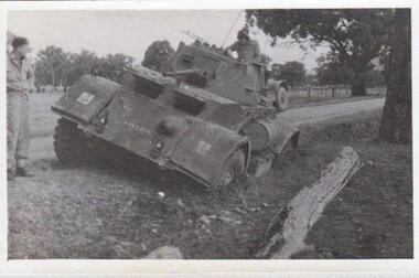
The 8th/13th Victorian Mounted Rifles was raised as a regiment of the Royal Australian Armoured Corps on 1 May 1948 with Headquarters in Melbourne and squadrons in Sale, Benalla/Wangaratta and Albury. In 1955 Regimental Headquarters moved to Wangaratta and a second squadron was located at Albury. The Sale squadron transferred to 4th/19th Prince of Wales’s Light Horse. In 1977 8/13 VMR Regiment was reduced to an independent squadron A Squadron 8th/13th Victorian Mounted Rifles and in 1991 was linked with 4th/19th Prince of Wales’s Light Horse forming the VMR Squadron of that regiment.Collection of photographs showing early evolution of an armoured regiment of the Citizen Forces as it progressed from WWII equipment and uniforms to post-war equipment and uniforms. Silver regimental hat badges are worn in place of Rising Sun badge.Black and white photograph of Staghound Armoured Car heavily bogged on exercise in Chiltern Forest near Albury. Has formation sign of 2nd Armoured Brigade on right mudguard." 1956 Staghound Armrd ( sic ) exercise in Chiltern / Rutherglen area " -
 Southern Sherbrooke Historical Society Inc.
Oral history - Belgrave, "Memories of Belgrave"
Photocopy of a newsletter article, dated 2 May 1995. Marcus Tarrant, a Black Rock resident, writes about Belgrave c. 1925. The newsletter is dated 22 Jul 1995.belgrave, sherbrooke forest, puffing billy -
Southern Sherbrooke Historical Society Inc.
Typescript|Photograph - copy
Single page typescript composed by Jill A'Vard, and single page with four copies of photographs. -Micawber Park Picnic Ground Belgrave c. 1934 shows a forest scene, a creek with a large tree fallen across it, a wooden footbridge, and a man in a hat standing on the bridge. Black and white photo. -Micawber Tea Rooms Belgrave shows a group of two men and two women standing on the verandah of a building which bears the signs "Refreshments", "Hot water" and "Micawber Tea Rooms". Black and white photo. -Ted & Lil A'Vard sitting in their lounge room at Micawber Park c. 1935 shows a middle-aged couple in armchairs in front of a brick fireplace. The mantelpiece holds several items including a clock. Behind the woman, on the right side, is a wooden stand with a green vase holding an arrangement of autumn-coloured flowers and foliage. The man is holding a book and there is possibly a dark dog at the woman's feet. Black and white photo which has been coloured in the top right corner (flower vase and edge of mantelpiece). -Alf & Maggie A'Vard's "The Valley" is a Rose Series postcard P. 1488, showing a house in a forest setting with a group of people on the verandah.albert a'vard, a'vard family, micawber park, alf a'vard, the valley -
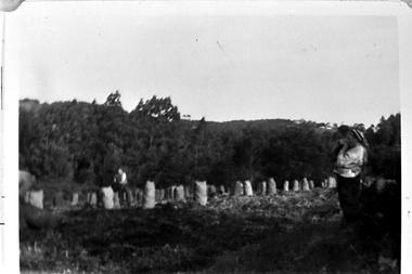
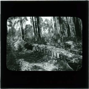 Southern Sherbrooke Historical Society Inc.
Photograph, Termite fence line test, Belgrave
Black and white photo, c.1923-32, taken from a lantern slide, showing a termite fence line test along a termite-infested log. Log is surrounded by open forest. -
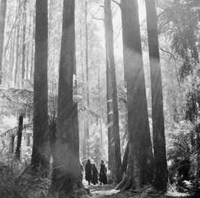 Southern Sherbrooke Historical Society Inc.
Photograph, Sherbrooke Forest 1968
Black and white photo showing a group of four or more people walking in Sherbrooke Forest between mountain ash trees. Treeferns are also visible. Created by the Australian News and Information Bureau. -
 Southern Sherbrooke Historical Society Inc.
Photograph
Black and white photo of Sherbrooke Forest in 1968. A group of people in summer attire are walking along an open track between treeferns and tall gum trees. Created for the Australian News and Information Bureau. -
 Southern Sherbrooke Historical Society Inc.
Photograph - Bagging potatoes on Hermon farm, Menzies Creek
Series of black and white photos showing workers bagging potatoes and loading onto trucks. These were taken on the Hermon farm on Black Hill Road, Menzies Creek. The Hermon family leased this land from the State Forest Commission.