Showing 1307 items matching " commercial road"
-
 Glen Eira Historical Society
Letter - Hawthorn Road, 566, Caulfield
... Road and North Road, South Caulfield. Current address is 566 ...Three paged letter dated 18/08/1980 from Food Plus Stores to City of Caulfield giving support factors re proposed redevelopment for a Food Plus Store corner of Hawthorn Road and North Road, South Caulfield. Current address is 566 Hawthorn Road, Caulfield.hawthorn road, caulfield, food stores plus, city of caulfield, petrol stations, shops, employment, commercial establishments -
 Eltham District Historical Society Inc
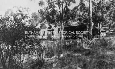
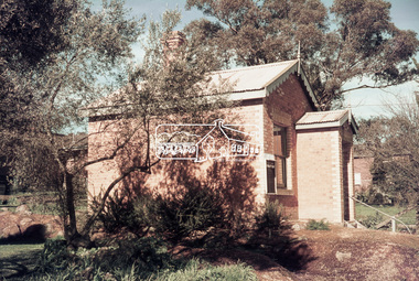
Photograph - Digital copy of photograph, Former Griffith family home, Banoon Road, Eltham, c.1955
Former family home of Mr. Frederick Eldred (Fred) Griffith in the 1950s, where present day Griffith Park is situated on the Yarra River at Eltham. Fred Griffith was also a Councillor (1945, 1951-1953) and former Shire President (1951) of the Shire of Eltham. Faye Walker (nee Harris) spent her first ten years living in the house. She recalls "there was a huge tin shed to the rear but toward the east of the house. I assume this is what people were thinking of when reference was made to the ‘’packing shed’. When I was small in the 50s, the shed was no longer being used for fruit packing but by the Griffith family as storage. Many of the pear trees remained but were no longer a commercial venture. We used to sneak up to the shed to read the National Geographic Magazines."griffith park, eltham, frederick eldred griffith, faye walker (nee harris) collection -
Glen Eira Historical Society
Article - Brunning, Leslie Herbert Ashby
An extract about Brunning’s Nurseries, St Kilda, taken from John Butler Cooper’s The History of St Kilda, from its first settlement to a city and after 1840 to 1930, Vol II. The extract is a short history of Brunning’s Nurseries, St Kilda. Includes a handwritten note by Deborah Towns citing the source, dated 08/07/2011.brunning george, brunning george edward, brunning herbert, brunning’s nurseries, g brunning and sons, st kilda, brunning street, brighton road, gardening, st kilda council, agricultural industry, commercial establishment -
 Glen Eira Historical Society
Article - Methodist Church, Grange Road, 183 – 185, Glen Huntly
1/A photocopy of a typed document of notes, source and date unknown, describing a brief history of the former Methodist Church in Grange Road, GlenHuntly. 2/Two colour photographs dated November 1980 of the front and side view of the church, and two undated photographs of the foundation stones, laid 1922 for the church and 1932 for the brick hall. 3/Also a newspaper article by Andrew Molloy dated 25/02/1990 discussing development options for potential buyers, source unknown.glen huntly, smith a. w. f. mr, foundation stones, grange road, molloy andrew, land sales, glen huntly road, methodist church, auctions, wattle ave., uniting church, churches, king f. l mr., presbyterian church of eastern australia, monuments and memorials, temples, religious ceremonies, chinese community, real estate agents, commercial development, residential development, child care, glen huntly post office, official buildings, weatherboard buildings, clergy, church residences, meeting rooms -
Glen Eira Historical Society
Article - Glen Huntly (House)
Photocopy of a short newspaper article from the Southern Cross, dated 18/06/1986, about Thomas Watt, who built Glen Huntly in 1855, one of the first substantial homes in the area. Refers briefly to the suburb’s residential and commercial development and includes a photograph (60mm x 145mm) of the exterior of Glen Huntly house and two photographs (37mm x 57mm) of the surrounding suburb. The file also includes a copy of a one page letter to the Historical Society of St Kilda from Nancy Renfree, dated 11/02/2000, about her great-grandfathers Thomas Watt and Henry Bunn, giving brief biographical information about both.glen huntly, glenhuntly, watts thomas, wilson john w, pioneers, huntly street, grange road, glenhuntly road, glen huntly road, architects, caulfield, station place, glenhuntly traders’ association, murray street, holy cross church, ricketson henry, glen eira, caulfield military hospital, caulfield, roads board, bunn henry, hotham street, ripponlea, weatherboard buildings, renfree nancy -
Glen Eira Historical Society
Document - Glenhuntly Road, Elsternwick
Three three page extracts from Andrew Ward’s 1994 Caulfield Conservation Study on commercial buildings in Glen Huntly Road, Elsternwick. The three studies concern Moore’s Buildings 1891 shops at 305-313 Glen Huntly Road, shops at 323-329 Glen Huntly Road and E J Buckeridge’s Buildings 1911 shops at 357-371 Glen Huntly Road. The studies describe the buildings’ architectural features, provide a historical overview and statements of the buildings’ significance, especially in relation to the Land Boom and commercial development between 1890 to the 19020s. All three studies include a black and white photograph (109mm x 152mm; 114mm x 150mm; 110mm x 151mm) of the shop fronts.glen huntly road, moore’s buildings 1891, italianate style, architectural styles, architectural features, verandahs, elsternwick, moore hugh, selwyn street, st georges road, glenmoore, glenmoore estate, corkill french and pugh, jamieson w w, thompson a g, eddy henrietta, valey frank, allen thomas, saddlers, dairy products, green w i, undertakers, delany edward, drapers, herbenstreit huldreich, butcher shops, sincock john, plumbers, allen t, greengrocers, coppel george, painters, dickinson f h, dickinson v, johnson thomas, cole constance, hairdressers, ortner frank, drycleaners, gaffney elodie, ward andrew, long mr, robinson mr, le page mr, byers robert, carter mary, millar c, smythe f c, crook thomas, stancy h, crook’s national stores pty ltd, e j buckeridge’s buildings 1911, kelly walter, staniland grove, buckeridge edward, hannon john, kellett frances, beck miss, armstrong miss, tuck mary, milliners, doherty john, adams herbert, bakeries, perry robert, picture framers, adams clifford, arches, windows, shops, land subdivision, retail trade, property developers, advertising signs -
Glen Eira Historical Society
Document - Beauville Estate
Promotional material for the Beauville Estate Murrumbeena 65th Heritage Celebration held 10/03/2001. This comprises, a leaflet about the launch of the Glen Eira Heritage Draft Guidelines with features of the Estate and addresses listed, a special invitation to the unveiling of the heritage plaque by Glen Eira Mayor Veronika Martens, and a Leader newspaper advertisement dated 12/02/2001 for the event, giving brief history of shops and resident anecdotes by Bev Baxter of Murrumbeena Pharmacy.beauville estate, murrumbeena, lindsay avenue 40-44 (even), 229-233 murrumbeena road, beaville avenue, gloucester court, dalny road 5-25 (north side only), 232-242 murrumbeena road (even), glen eira heritage draft guidelines, murrumbeena pharmacy, a v jennings, 227-235 murrumbeena road, barker ann, martens veronica, baxter bev, heritage festivals, plaques, quinn miss, webb rosemary, webb roy, cleave edna may, quirk john, quirk eva, ritchie, kirkbride thomas, beauville, glen eira port phillip pulse small business awards 2000, architectural features, brick houses, shops, residential development, tennis courts, housing estates, builders, building regulations, local government, commercial development, children’s playgrounds, advertisements, invitations, pharmacies, grocers, dentists, greengrocers, butchery shops, sweet shops -
Glen Eira Historical Society
Document - Beauville Estate
Beauville Estate Draft Heritage Guidelines, July 2000, produced by the Glen Eira City Council, author unknown, 25 pages. The Guidelines set out design parameters, principles and techniques for achieving appropriate heritage conservation objectives for the defined Beauville Estate Heritage Area, to be used by the Council, property owners, residents and designers. A number of photographs of houses and design features are included in the document as well as a brief history of the Estate and a Key Design Checklist.a v jennings construction co, gurney edward, jennings albert v sir, beauville estate, beauville estate heritage area, beauville avenue 1-39 (odd), beauville avenue 2-36 (even), dalny road 3-25 (odd), gloucester court 1-3 (odd), gloucester court 2-6 (even), lindsay avenue 40-44 (even), murrumbeena road 227-233 (odd), murrumbeena road 222-232 (even), murrumbeena, glen eira city council, architectural features, architectural styles, plans, brick houses, shops, residential development, tennis courts, housing estates, builders, building regulations, local government, commercial development, history, maps, photographs -
 Eltham District Historical Society Inc
Photograph, Frank Stokes with daughters Dorothy (left) and Beryl (right) at Stokes Orchard, Nyora Road, Eltham, 1944, 1944
Frank Stokes first traveled to the district by train in 1944 to find land with the intention to establish an orchard. By chance he met Arthur Bird of Bird Orchard (bounded by Pitt Street, Eucalyptus Road and Wattle Grove) and they got talking over their common interest. Arthur put Frank up for the night and pointed out the land, part of Crown Allotment 15, Section 5, Parish of Nillumbik (CA15) somewhat diagonally opposite Bird Orchard. Frank bought the land and for the next two years would travel by train from Melbourne to Eltham every weekend establishing Stokes Orchard and building a home for his family, which they eventually moved into in 1946. In the mid 1970s the Shire of Eltham divided the orchard up into numerous rate-able parcel lots, which became affordable for Frank. As a consequence Stokes Orchard was turned into a housing development by Macquarie Builders and marketed as the Stokes Orchard Estate in two stages; Stage 1 encompassing Scarlet Ash Court, Ironbark Close and Peppermint Grove bounded by Nyora and Eucalyptus roads c.1976 and Stage 2 encompassing Stokes Place, Orchard Way, The Crest and The Lookout bound by Nyora and Diosma roads c.1979. The development of Orchard Way, The Crest and The Lookout did not proceed as planned due to the lack of the sewer along Diosma Road and so many of the proposed lots were incorporated into five-acre parcels instead.Representative of the orchard growing areas of ElthamDigital file only - Digitised by EDHS from a scrapbook (containing commercially printed photos of digital scans) on loan from Beryl Bradbury (nee Stokes), daughter of Frank Stokes.1944, beryl bradbury (nee stokes), beryl bradbury (nee stokes) collection, dorothy stokes, eltham, frank stokes, nyora road, stokes orchard -
 Eltham District Historical Society Inc
Photograph, Frank Stokes with his mother Florence (nee West) and children, Dorothy (left), David (centre) and Beryl (right), Stokes Orchard, Nyora Road, Eltham, c.1950, 1950c
Frank's mother Florence was visiting from England at the time. Frank Stokes first traveled to the district by train in 1944 to find land with the intention to establish an orchard. By chance he met Arthur Bird of Bird Orchard (bounded by Pitt Street, Eucalyptus Road and Wattle Grove) and they got talking over their common interest. Arthur put Frank up for the night and pointed out the land, part of Crown Allotment 15, Section 5, Parish of Nillumbik (CA15) somewhat diagonally opposite Bird Orchard. Frank bought the land and for the next two years would travel by train from Melbourne to Eltham every weekend establishing Stokes Orchard and building a home for his family, which they eventually moved into in 1946. In the mid 1970s the Shire of Eltham divided the orchard up into numerous rate-able parcel lots, which became affordable for Frank. As a consequence Stokes Orchard was turned into a housing development by Macquarie Builders and marketed as the Stokes Orchard Estate in two stages; Stage 1 encompassing Scarlet Ash Court, Ironbark Close and Peppermint Grove bounded by Nyora and Eucalyptus roads c.1976 and Stage 2 encompassing Stokes Place, Orchard Way, The Crest and The Lookout bound by Nyora and Diosma roads c.1979. The development of Orchard Way, The Crest and The Lookout did not proceed as planned due to the lack of the sewer along Diosma Road and so many of the proposed lots were incorporated into five-acre parcels instead.Representative of the orchard growing areas of ElthamDigital file only - Digitised by EDHS from a scrapbook (containing commercially printed photos of digital scans) on loan from Beryl Bradbury (nee Stokes), daughter of Frank Stokes.1950, beryl bradbury (nee stokes), beryl bradbury (nee stokes) collection, david stokes, dorothy stokes, eltham, flatbed truck, florence stokes (nee west), frank stokes, nyora road, stokes orchard -
 Eltham District Historical Society Inc
Photograph, Stokes family, Nyora Road, Eltham, c.1952, 1952c
Taken from outside the family home on the southest corner of the intersection of Nyora Road and Pitt Street with Eucalyptus Road, looking northeast across the Stokes Orchard L-R: David, Howard, Beryl (kneeling), Dorothy and Gladys Stokes with Gladys's mother sitting in Gladys's father's car with Spot the dog, Nyora Road, Eltham, c.1952 Frank Stokes first traveled to the district by train in 1944 to find land with the intention to establish an orchard. By chance he met Arthur Bird of Bird Orchard (bounded by Pitt Street, Eucalyptus Road and Wattle Grove) and they got talking over their common interest. Arthur put Frank up for the night and pointed out the land, part of Crown Allotment 15, Section 5, Parish of Nillumbik (CA15) somewhat diagonally opposite Bird Orchard. Frank bought the land and for the next two years would travel by train from Melbourne to Eltham every weekend establishing Stokes Orchard and building a home for his family, which they eventually moved into in 1946. In the mid 1970s the Shire of Eltham divided the orchard up into numerous rate-able parcel lots, which became affordable for Frank. As a consequence Stokes Orchard was turned into a housing development by Macquarie Builders and marketed as the Stokes Orchard Estate in two stages; Stage 1 encompassing Scarlet Ash Court, Ironbark Close and Peppermint Grove bounded by Nyora and Eucalyptus roads c.1976 and Stage 2 encompassing Stokes Place, Orchard Way, The Crest and The Lookout bound by Nyora and Diosma roads c.1979. The development of Orchard Way, The Crest and The Lookout did not proceed as planned due to the lack of the sewer along Diosma Road and so many of the proposed lots were incorporated into five-acre parcels instead.Representative of the orchard growing areas of ElthamDigital file only - Digitised by EDHS from a scrapbook (containing commercially printed photos of digital scans) on loan from Beryl Bradbury (nee Stokes), daughter of Frank Stokes.1948-1951 vauxhall velox, 1948-1951 vauxhall wyvern, 1952, beryl bradbury (nee stokes), beryl bradbury (nee stokes) collection, david stokes, dorothy stokes, eltham, gladys stokes, nyora road, spot (dog), stokes orchard -
 Eltham District Historical Society Inc
Photograph, Stokes family with horse and sled, Nyora Road, Eltham, c.1950, 1950c
Taken from outside the family home on the southest corner of the intersection of Nyora Road and Pitt Street with Eucalyptus Road, looking northeast across the Stokes Orchard Frank Stokes with children, Dorothy (left), Beryl and David Frank Stokes first traveled to the district by train in 1944 to find land with the intention to establish an orchard. By chance he met Arthur Bird of Bird Orchard (bounded by Pitt Street, Eucalyptus Road and Wattle Grove) and they got talking over their common interest. Arthur put Frank up for the night and pointed out the land, part of Crown Allotment 15, Section 5, Parish of Nillumbik (CA15) somewhat diagonally opposite Bird Orchard. Frank bought the land and for the next two years would travel by train from Melbourne to Eltham every weekend establishing Stokes Orchard and building a home for his family, which they eventually moved into in 1946. In the mid 1970s the Shire of Eltham divided the orchard up into numerous rate-able parcel lots, which became affordable for Frank. As a consequence Stokes Orchard was turned into a housing development by Macquarie Builders and marketed as the Stokes Orchard Estate in two stages; Stage 1 encompassing Scarlet Ash Court, Ironbark Close and Peppermint Grove bounded by Nyora and Eucalyptus roads c.1976 and Stage 2 encompassing Stokes Place, Orchard Way, The Crest and The Lookout bound by Nyora and Diosma roads c.1979. The development of Orchard Way, The Crest and The Lookout did not proceed as planned due to the lack of the sewer along Diosma Road and so many of the proposed lots were incorporated into five-acre parcels instead.Representative of the orchard growing areas of ElthamDigital file only - Digitised by EDHS from a scrapbook (containing commercially printed photos of digital scans) on loan from Beryl Bradbury (nee Stokes), daughter of Frank Stokes.1950, beryl bradbury (nee stokes), beryl bradbury (nee stokes) collection, david stokes, dorothy stokes, eltham, frank stokes, horse, nyora road, sled, stokes orchard -
 Eltham District Historical Society Inc
Photograph, The Stokes family home blanketed with snow, corner Nyora and Eucalyptus roads, Eltham, winter 1951, 1951
Taken from outside the family home on the southest corner of the intersection of Nyora Road and Pitt Street with Eucalyptus Road. Frank Stokes first traveled to the district by train in 1944 to find land with the intention to establish an orchard. By chance he met Arthur Bird of Bird Orchard (bounded by Pitt Street, Eucalyptus Road and Wattle Grove) and they got talking over their common interest. Arthur put Frank up for the night and pointed out the land, part of Crown Allotment 15, Section 5, Parish of Nillumbik (CA15) somewhat diagonally opposite Bird Orchard. Frank bought the land and for the next two years would travel by train from Melbourne to Eltham every weekend establishing Stokes Orchard and building a home for his family, which they eventually moved into in 1946. In the mid 1970s the Shire of Eltham divided the orchard up into numerous rate-able parcel lots, which became affordable for Frank. As a consequence Stokes Orchard was turned into a housing development by Macquarie Builders and marketed as the Stokes Orchard Estate in two stages; Stage 1 encompassing Scarlet Ash Court, Ironbark Close and Peppermint Grove bounded by Nyora and Eucalyptus roads c.1976 and Stage 2 encompassing Stokes Place, Orchard Way, The Crest and The Lookout bound by Nyora and Diosma roads c.1979. The development of Orchard Way, The Crest and The Lookout did not proceed as planned due to the lack of the sewer along Diosma Road and so many of the proposed lots were incorporated into five-acre parcels instead.Representative of the orchard growing areas of Eltham. One of the rare times it has snowed in ElthamDigital file only - Digitised by EDHS from a scrapbook (containing commercially printed photos of digital scans) on loan from Beryl Bradbury (nee Stokes), daughter of Frank Stokes.1951, beryl bradbury (nee stokes) collection, eltham, eucalyptus road, nyora road, snow, stokes family home -
 Eltham District Historical Society Inc
Photograph, The Stokes family home and orchard blanketed with snow, corner Nyora and Eucalyptus roads, Eltham, Winter 1951, 1951
Taken from outside the family home on the southest corner of the intersection of Nyora Road and Pitt Street with Eucalyptus Road. Frank Stokes first traveled to the district by train in 1944 to find land with the intention to establish an orchard. By chance he met Arthur Bird of Bird Orchard (bounded by Pitt Street, Eucalyptus Road and Wattle Grove) and they got talking over their common interest. Arthur put Frank up for the night and pointed out the land, part of Crown Allotment 15, Section 5, Parish of Nillumbik (CA15) somewhat diagonally opposite Bird Orchard. Frank bought the land and for the next two years would travel by train from Melbourne to Eltham every weekend establishing Stokes Orchard and building a home for his family, which they eventually moved into in 1946. Marjorie North remembered well the winter of 1951, when she took children, including son John together with the Shallard and Squire children “in the Austin A40 up the Main Rd., Eltham to farmer Bell’s property alongside the Eltham College. They were able to make a snow man and throw snowballs. (Diamond Valley News, August 5, 1986.p.42) In the mid 1970s the Shire of Eltham divided the orchard up into numerous rate-able parcel lots, which became affordable for Frank. As a consequence Stokes Orchard was turned into a housing development by Macquarie Builders and marketed as the Stokes Orchard Estate in two stages; Stage 1 encompassing Scarlet Ash Court, Ironbark Close and Peppermint Grove bounded by Nyora and Eucalyptus roads c.1976 and Stage 2 encompassing Stokes Place, Orchard Way, The Crest and The Lookout bound by Nyora and Diosma roads c.1979. The development of Orchard Way, The Crest and The Lookout did not proceed as planned due to the lack of the sewer along Diosma Road and so many of the proposed lots were incorporated into five-acre parcels instead.Representative of the orchard growing areas of Eltham. One of the rare times it has snowed in Eltham.Digital file only - Digitised by EDHS from a scrapbook (containing commercially printed photos of digital scans) on loan from Beryl Bradbury (nee Stokes), daughter of Frank Stokes.1951, beryl bradbury (nee stokes) collection, eltham, nyora road, eucalyptus road, snow, stokes family home -
 Eltham District Historical Society Inc
Photograph, The first houses in construction on the new Stokes Orchard Estate, July 1976, July 1976
Viewed from near the Stokes family home at 1 Nyora Road looking northeast across Ironbark Close to Scarlet Ash Court with Peppermint Grove in the distance. Frank Stokes first traveled to the district by train in 1944 to find land with the intention to establish an orchard. By chance he met Arthur Bird of Bird Orchard (bounded by Pitt Street, Eucalyptus Road and Wattle Grove) and they got talking over their common interest. Arthur put Frank up for the night and pointed out the land, part of Crown Allotment 15, Section 5, Parish of Nillumbik (CA15) somewhat diagonally opposite Bird Orchard. Frank bought the land and for the next two years would travel by train from Melbourne to Eltham every weekend establishing Stokes Orchard and building a home for his family, which they eventually moved into in 1946. In the mid 1970s the Shire of Eltham divided the orchard up into numerous rate-able parcel lots, which became affordable for Frank. As a consequence Stokes Orchard was turned into a housing development by Macquarie Builders and marketed as the Stokes Orchard Estate in two stages; Stage 1 encompassing Scarlet Ash Court, Ironbark Close and Peppermint Grove bounded by Nyora and Eucalyptus roads c.1976 and Stage 2 encompassing Stokes Place, Orchard Way, The Crest and The Lookout bound by Nyora and Diosma roads c.1979. The development of Orchard Way, The Crest and The Lookout did not proceed as planned due to the lack of the sewer along Diosma Road and so many of the proposed lots were incorporated into five-acre parcels instead.Housing development in Eltham as an extension to the Woodridge EstateDigital file only - Digitised by EDHS from a scrapbook (containing commercially printed photos of digital scans) on loan from Beryl Bradbury (nee Stokes), daughter of Frank Stokes.1976-07, beryl bradbury (nee stokes) collection, building construction, ironbark close, nyora road, peppermint grove, scarlet ash court, stokes orchard estate, houses -
 Eltham District Historical Society Inc
Photograph, Looking south towards Nyora Road, Eltham, 1977, 1977
Viewed from near the end of Stokes Place where the linear reserve now runs between 8 and 9 Stokes Place just visible through trees in foreground, 24 Nyora with red roof is the first house in middle of view. Frank Stokes first traveled to the district by train in 1944 to find land with the intention to establish an orchard. By chance he met Arthur Bird of Bird Orchard (bounded by Pitt Street, Eucalyptus Road and Wattle Grove) and they got talking over their common interest. Arthur put Frank up for the night and pointed out the land, part of Crown Allotment 15, Section 5, Parish of Nillumbik (CA15) somewhat diagonally opposite Bird Orchard. Frank bought the land and for the next two years would travel by train from Melbourne to Eltham every weekend establishing Stokes Orchard and building a home for his family, which they eventually moved into in 1946. In the mid 1970s the Shire of Eltham divided the orchard up into numerous rate-able parcel lots, which became affordable for Frank. As a consequence Stokes Orchard was turned into a housing development by Macquarie Builders and marketed as the Stokes Orchard Estate in two stages; Stage 1 encompassing Scarlet Ash Court, Ironbark Close and Peppermint Grove bounded by Nyora and Eucalyptus roads c.1976 and Stage 2 encompassing Stokes Place, Orchard Way, The Crest and The Lookout bound by Nyora and Diosma roads c.1979. The development of Orchard Way, The Crest and The Lookout did not proceed as planned due to the lack of the sewer along Diosma Road and so many of the proposed lots were incorporated into five-acre parcels instead.Housing development in Eltham as an extension to the Woodridge EstateDigital file only - Digitised by EDHS from a scrapbook (containing commercially printed photos of digital scans) on loan from Beryl Bradbury (nee Stokes), daughter of Frank Stokes.1977, beryl bradbury (nee stokes) collection, nyora road, stokes orchard estate, stokes place -
 Eltham District Historical Society Inc
Photograph, Stokes Place, Eltham, July 1977, July 1977
Viewed from near the end of Stokes Place where the linear reserve now runs between 8 and 9 Stokes Place looking slightly east of south towards Nyora Road. The new Christian Church on Nyora now the Baptist Church visible in middle view. Frank Stokes first traveled to the district by train in 1944 to find land with the intention to establish an orchard. By chance he met Arthur Bird of Bird Orchard (bounded by Pitt Street, Eucalyptus Road and Wattle Grove) and they got talking over their common interest. Arthur put Frank up for the night and pointed out the land, part of Crown Allotment 15, Section 5, Parish of Nillumbik (CA15) somewhat diagonally opposite Bird Orchard. Frank bought the land and for the next two years would travel by train from Melbourne to Eltham every weekend establishing Stokes Orchard and building a home for his family, which they eventually moved into in 1946. In the mid 1970s the Shire of Eltham divided the orchard up into numerous rate-able parcel lots, which became affordable for Frank. As a consequence Stokes Orchard was turned into a housing development by Macquarie Builders and marketed as the Stokes Orchard Estate in two stages; Stage 1 encompassing Scarlet Ash Court, Ironbark Close and Peppermint Grove bounded by Nyora and Eucalyptus roads c.1976 and Stage 2 encompassing Stokes Place, Orchard Way, The Crest and The Lookout bound by Nyora and Diosma roads c.1979. The development of Orchard Way, The Crest and The Lookout did not proceed as planned due to the lack of the sewer along Diosma Road and so many of the proposed lots were incorporated into five-acre parcels instead.Housing development in Eltham as an extension to the Woodridge EstateDigital file only - Digitised by EDHS from a scrapbook (containing commercially printed photos of digital scans) on loan from Beryl Bradbury (nee Stokes), daughter of Frank Stokes.1977-07, beryl bradbury (nee stokes) collection, eltham, eltham christian church, stokes orchard estate, stokes place -
 Eltham District Historical Society Inc
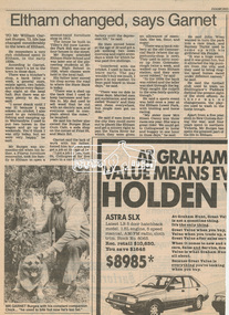
Newsclipping, Eltham changed, says Garnet, Diamond Valley News, 1987c
Digital file only - Digitised by EDHS from a scrapbook on loan from Beryl Bradbury (nee Stokes), daughter of Frank Stokes.beryl bradbury (nee stokes) collection, blue gum, burges blue gum cafe, commercial bank of australia, eileen owen (nee burges), eltham high school, eltham lower park, eltham shire office, eltham state school, garnet burges, horse racing, ida pender, john wren, lavender park road, main road, opportunity shop, pryor street, race track, robbery, shillinglaw's paddock, squizzy taylor, state school no. 209, tilley's road, william garnet burges -
 Eltham District Historical Society Inc
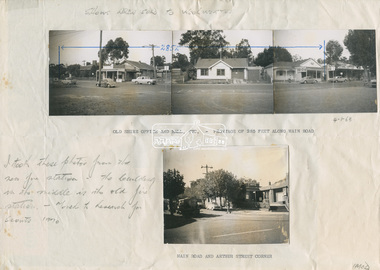
Document - Photograph, Ian McDonald (Shire of Eltham), Main Road, between Arthur Street and Dudley Street, Eltham, 1968-1970
Original document produced by Ian McDonald (Eltham Shire Council) 1970. During the period 1969-1971 photos were being collected for a proposed publication on the history of the Shire of Eltham as part of its centenary celebrations in 1971 (managed by the Shire of Eltham Historical Society and Alan Marshall). The publication was Pioneers & Painters (1971), edited by Alan Marshall. The document titled "Shows area sold to Woolworths" consisted of a panorama of three B&W photo prints creating a panorama of the frontage along Main Road (SEPP_0744) and a single B&W photo print of the Shire of Eltham offices and Hall on the corner of Arthur Street and Main Road (SEPP_0737) along with typed and hand written notes by Ian McDonald. The panorama (SEPP_0744) was captioned in typewritten text "Old Shire Office and Hall, etc - Frontage of 285 feet along Main Road" and in pencil the date "4-1-68" The single image of the shire offices (SEPP_0737) was captioned in typewritten text "Main Road and Arthur Street Corner" In addition, the following handwritten notes in pencil: " I took these photos from the new fire station - the building in the middle is the old fire station - Moved to Research for the Scouts 1970" and signed "IMcD"This photo forms part of a collection of photographs gathered by the Shire of Eltham for their centenary project book,"Pioneers and Painters: 100 years of the Shire of Eltham" by Alan Marshall (1971). The collection of over 500 images is held in partnership between Eltham District Historical Society and Yarra Plenty Regional Library (Eltham Library) and is now formally known as the 'The Shire of Eltham Pioneers Photograph Collection.' It is significant in being the first community sourced collection representing the places and people of the Shire's first one hundred years.Paper with four photos adhered in two groups with notes in typewritten text and handwritten in pencilsepp, shire of eltham pioneers photograph collection, eltham, main road, arthur street, dudley street, barber shop, cinema, commercial bank of australia, eltham fire brigade, eltham hall, eltham shire hall, eltham shire office, fire station, hardware shop, municipal offices, photographer shop, pph, produce paint and hardware centre, shire hall, shire offices, woolworths -
 Eltham District Historical Society Inc
Film - Video (VHS), IMP Productions, The Shire of Etham - The Evergreen Shire (Series 69, Item 4), c.1985
Shire of Eltham Archives: Series 69, Item 4 This video was produced for the Shire of Eltham by IMP Productions and provides a description of the shire, 277 square km on a north/northeast axis, some 25 km northeast of the centre of Melbourne with a population of around 40,000. Scenes include Yarra River, rural settings and urban settings, housing estates, Shillinglaw Cottage, Pigeon Bank at Kangaroo Ground, the Eltham Railway Trestle Bridge with reference to the fight by locals in the 1970s to save it from replacement, Montsalvat, mudbrick making and its use as a building material, the use of mudbrick in the Eltham Community Centre blending harmoniously with the environment. Emphasises people living in the area due to the qualities of life provided. Also the Living and Learning Centre, St Andrews Markets and other local markets, the Eltham Leisure Centre, cricket and horse riding at Eltham Lower Park, the Infant Welfare Centre (part of the Eltham War Memorial), how residents are mindful of protecting their historical heritage, the CBA bank and Allwood House at Hurstbridge, Tracey Naughton about the Eltham "As we are" Community Banner project and the “River of Life banner”, the Parks and Gardens office in the former Police Residence building (now the Local History Centre), Alistair Knox Park, road planning and types of roads, tree canopy, Peck's Dam, green carparks, road drainage, Gordon Ford's garden and natural landscapes, and Were Street shops in Montmorency. Planning for shopping facilities and carparks with a population of 40,000 growing to 55,000, Arthur Street Mall and carpark, local village feel in the shopping centre. Councillors and Council staff featured include Mary Grant, Bob Manuell, Rodney Roschellor, John Cohen, Alan Baker. Also scenes of Commercial Place, Diamond Valley Railway, Eltham Galley, Riverclay and canoeing on the Yarra intermingled with images of the shire from the Shire of Eltham Pioneers Photograph collection.VHS Video cassette Converted to MP4 file format 00:11:56; 79MBshire of eltham, video recording, shire of eltham archives, alistair knox park, allwood house, arthur street, arthur street mall, bob manuell, canoeing, carparks, cba bank, commercial place, council staff, councillors, cr. mary grant, cricket, diamond valley railway, eltham community banner project, eltham community centre, eltham galley, eltham leisure centre, eltham living and learning centre, eltham lower park, eltham railway trestle bridge, eltham war memorial, gordon ford garden, horse riding, housing estates, hurstbridge, infant welfare centre, john cohen, kangaroo ground, local history centre, montmorency, montsalvat, mudbrick, parks and gardens, peck's dam, pigeon bank, police residence, river of life banner, riverclay, road drainage, road planning, rodney roschellor, shillinglaw cottage, shire of eltham pioneers photograph collection, st andrews market, tracey naughton, tree canopy, were street, yarra river, alan baker -
 Eltham District Historical Society Inc
Document - Map, Doug Orford, Main Road, Eltham (c..1930s-1970s), c.2010
Map of Main Road with listings of all properties (shops/homes) from Mount Pleasant Road through to Pryor Street from the 1930s on to about the 1970sandrew store, andrews newsagency, arthur street, babe taylor house, bakery, barbers blue gum store, blue gum, boarding house, bootmakers cottage, bottle shop, bradford butcher shop, bradford house, bradley house, brdbury house, bridge street, brooker, brougham steet, brown blacksmith, browne's grocer, bryant, burgoyne post office, burgoyne's shop, capewell butcher shop, catholic church, catholic school, chandlers lolly shop, cheddar black, chiropractor, cockcroft, commercial bank of australia, copelands chemist, copelands dairy, d. hall house, dave lyon house, david lyon house, dr cordner, dr loosli, dr r. bradbury, dudley street, eltham, eltham bakehouse, eltham courthouse, eltham fire brigade, eltham living and learning centre, eltham pre-school, eltham railway station, eltham shire office, eltham station masters house, eltham war memorial, f. collis store, feed store, fountain hotel, franklin street, gadd's blacksmith, gahan house, garnet burges, george bird grocer, gollings, grant house, harry hawker, headmaster's resience, henry street, hepburn house, hills house, isherwood house and shop, jack ryan, jack shallard, james house, jarrold cottage, jim ryan, john lyon house, kilpatrick, le brocq, leather and harness, len parsons, lock-up, lyon bros garage, main road, map, mathews house, mclean's produce store, mechanics institute, methodist church, methodist hall, milkbar, mills bootmaker, miss george, monteith house, mount pleasant road, mrs bradbury, mrs davis house, mrs jewell, mrs mbremner store, mrs morris shop, napoleon street, obelisk, panther place, peter gahan, pitt street, plumber, police residence, poultry and market garden, pryor street, railway house, rains newsagency, real estate agent, reeves general store, s. bradbury, shillinglaw cottage, staffs general store, stones mixed shop, tennis court, timber yard, w. walker, w.b. andrew corn store, warren's general store, water trough, watsons hotel, websters house, whitecloud cottage, whites general store, williams bootmaker, wingrove cottage, wingrove park, woodyard, york street, franco and co -
 Eltham District Historical Society Inc
Photograph, Jim Connor, Former C.B.A. Bank, 14 Jan 2017
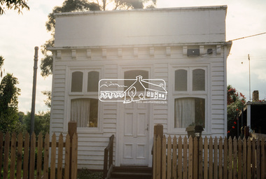
The Former Commonwealth Bank of Australia branch forms part of the Eltham Gateway and the Little Eltham precinct and is located near 804 Main Road, Eltham. It is a significant building and registered on the Victorian Heritage Register. The bank was built in 1878. It is a one-room, bichromatic brick building. Imagine your bank only being open for one morning a week! These were the hours of the Commercial Bank’s Eltham branch early in the 20th century and customers were quite content. The bank stored gold from the Eltham/Research mining areas. It is famous for its bullet holes. These were the result of a hold up in 1949, in which a nervous youth opened an account in the name of John Henderson, then walked to the door and spun around pulling out a pistol he fired into the cedar bench but fled empty handed and was apprehended later, receiving a two year sentence. The Bank was purchased by the Methodist Church in 1954. (The Eltham church is right adjacent). Recent uses have included a meeting room, Sunday School and Opportunity Shop. It is currently used as a storage for the Combined churches opportunity shop which is located in the United church extension beside this location. Tomorrow's history documented todayeltham, jim connor collection, main road, eltham gateway, cba bank, opportunity shop -
 Eltham District Historical Society Inc
Photograph, Former Commercial Bank of Australia buildiing, 901 Main Road, Hurstbridge, c.May 1988
35mm colour positive transparency (1 of 25) Mount - Kodak EktachromeProcess Date MAY 88Mcba bank, hurstbridge -
 Eltham District Historical Society Inc
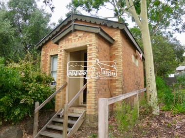
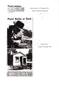
Folder, Commercial Bank of Australia Eltham Branch Hold-Up, 15 December 1949
Thursday, December 15, 1949, the quiet little bank was embroiled in an infamous wild shoot-out between a daring thief and two bank officers. Today, the building still carries the scars ; a bullet hole remains visible in a cedar bench testifying to the events that played out that day. 3.30 a.m., Friday, December 9. The manager of the Commercial Bank branch at Greensborough, Mr Harry Wallace and his wife are asleep in their bedroom of the little house behind the branch. Harry is awakened by a noise and sees an intruder in a corner of the bedroom. He calls out but the intruder who has switched off the power in anticipation flees through a side door and scarpers down Main Street. Harry summons the police but a search by First Constable Thomas of the Greensborough Police assisted by a wireless patrol car is unsuccessful. A report is filed noting the theft of a .25 calibre pistol from the wardrobe. Thursday, December 15th. It is 1pm and the Commercial Bank has just opened. The branch is only open Mondays and Thursdays from 1-3pm. The morning started off a little cool with some scattered showers but it has fined up and the temperature is now around 61 degrees (16 C). A new grey Singer sports car with soft-top pulls up on the opposite side of the road and a young man, neatly dressed in a dark blue suit, wearing a grey hat and carrying a brief case exits the vehicle. He looks around then crosses the road and walks up the steps and through the door into the bank. There are three people inside; Mr. Jack Burgoyne whose grocery store is situated just 50 yards up the road, Mr. Lindsay A. Spears, the Eltham Agency Receiving Officer and by chance, Mr Harry Wallace, manager of the Greensborough branch. Jack Burgoyne takes note of the young stranger; thinking to himself he appears nervous. The man approaches the counter and introduces himself as John Henderson of Greensborough and explains that he wishes to open a new account. He places his hat and £3 on the counter. Mr Spears attends to the paperwork. He asks the young man to sign two forms, which he does but then he withdraws from the counter and starts walking towards the door. Suddenly he spins around pulling an automatic pistol from his right-hand pocket. He exclaims forcefully; “The game’s on! I’ll take the lot!” Spears appears to comply by pretending to open a drawer. The man shouts loudly, “Keep your hand away from that drawer.” Spears instead reaches for a pistol in his pocket and challenges the man, “Here it is. Come and get it!” At the same time, Harry Wallace pulls a pistol from his pocket as well. The bandit fires a shot but misses, the bullet striking the counter. Both Spears and Wallace open fire and Jack Burgoyne ducks for cover. As the bandit turns and runs for the door leaving his £3 behind, he fires another shot, which strikes the ceiling. Spears fires back, and thinks he may have hit him in the foot. The bandit flees the bank and heads for the grey Singer car, registration NO-106, parked opposite. Wallace and Spears pursue him to the door and open fire again, striking the car three times around the driver’s door. Spears lets off eight shots and Wallace, seven before his gun jams. The getaway car initially heads slowly down Main Road towards Bridge Street. About 100 yards down the road, Dave Adams, a PMG employee, who has heard the shots, throws a steel manhole step at the driver. It hits the roof of the car nine inches above the driver’s head and tears the hood. Another witness claims to have seen the door blow open and the driver raise his hand. The car gathers speed and swings left into Bridge Street racing along at about 60 miles an hour careering recklessly past council employee, Mr. Percy Williams, who is driving a dray along Smarts Road [believed to be Bridge Street]. At the end of the road the Singer fails to get round the sharp turn and crashes into an embankment skidding to a stop outside the home of Mr John Clifford. One side of the car is wrecked. Mr Clifford, an aircraft engineer hears the fast travelling car bump heavily into the road bank at about 1.25 p.m. Hearing the whine of an engine he goes outside to find the grey Singer parked at the side of the road. Jack George also lives at the corner and hears the car crash. “The bandit opened the car door, ran 50 yards, and suddenly turned back,” exclaims Jack. “He took something from the car. It might have been a gun.” In his haste, the bandit drops his grey felt hat, size 6 7/8, on the road and dashes up Sherbourne Road for about 200 yards then disappears into the scrub carrying a brief case and a bundle in which a sailor’s cap can be seen. About 3 p.m., Mr H.D. Pettie of Mountain View Road, Montmorency is looking through his field glasses and notices a young man walking through thick scrub on private property some distance from his house. The man is wearing a sailor’s cap and disappears along the railway track toward Montmorency. As the day progresses, ten police cars, one motor cycle, and about 40 police led by Det. Sgt. McMennemin of Malvern CIB are searching for him. They believe he is hiding in thick scrub along the bank of the creek about half-a-mile outside Eltham township. Wireless patrol cars, four mobile traffic cars and the CIB area cars from Malvern and Kew are taking part. Police check the thief’s car and discover it was stolen from Helen Baxter, of Doncaster Road, North Balwyn from outside Victoria Barracks. Harry Wallace informs the police that he believes he recognised the bandit as the man who took his pistol from his bedroom the previous Friday morning. As night falls, armed police are posted at strategic points in the Eltham-Greensborough district. Police in cars are watching the roads. Others are searching the bush and checking passengers on trains. Little do they realise the young man has already slipped out of the net. SEQUEL YOUTH OF 19 CHARGED WITH ATTEMPTED ARMED ROBBERY OF BANK AT ELTHAM Weekly Times, Wednesday 15 February 1950, page 6 Detectives who raided a house in Bell St., Coburg, Melbourne, charged a 19-year-old youth, of South Yarra, with attempted armed robbery at the Commercial Bank’s Eltham (Vic.) receiving depot on Dec. 15. Police say they recovered a loaded automatic pistol, diamond and signet rings worth more than £200, a complete set of house-breaking instruments, a sailor’s uniform, and chloroform gauze in the raid. The youth was charged that while armed with an offensive weapon, he attempted to rob Lindsay George Spears of a sum of money. He was further charged on six counts of breaking, entering and stealing. Police allege that the person who tried to hold up Mr Spears in the Commercial Bank receiving depot at Eltham on December 15. escaped in a stolen car, after Mr Spears and Mr Henry Wallace, manager of the bank’s Greensborough branch, had fired at him. After the car crashed, he escaped into thick scrub and is alleged to have changed into a sailor’s uniform. On December 9 an automatic pistol was stolen from Mr Wallace’s bedroom at the Greensborough bank. The chloroform pad recovered is alleged to have been stolen from the Dental Supply Company, Plenty Road, Preston. The rings are alleged to have been taken in a £513 burglary from the shop of James Paton. Sydney Road, Coburg. Det. Sgt. H. McMennemin conducted the investigations with Senior Dets. R. Newton and M Downie, Detectives l. Dent, R. Rayner, P. Pedersen and M. Handley and First Constable A. Thomas. The youth will appear at Eltham Court on February 22. Manager’s Gun Used in Holdup at Bank The Age, Thursday 23 February 1950, page 4 It was stated in Eltham court yesterday that a youth who robbed a bank manager of his pistol, later used it in an attempt to hold-up the bank. Kay Arthur Morgan, 19, draftsman, of Castle-street, South Yarra, was committed for trial on charges of breaking and entering, and stealing a pistol and attempted robbery while armed with an offensive weapon. He pleaded guilty. The manager of Eltham branch of the Commercial Bank of Australia Ltd., Henry Clifton Cabot Wallace, said he disturbed someone in the bedroom, in which he and his wife were sleeping, at 3 a.m. on December. 9, 1949. Later he found that his automatic- pistol was missing. On December 15 a youth, who said his name was John Henderson, entered the bank and opened a new account. As the youth was leaving the bank he turned round with a pistol in his hand and said: — “I want the lot.” Spear indicated a drawer under the counter; and said.— “Here it is. Come and get it.” The youth said:— “Keep your hand away from that drawer.” Witness said Spear then drew his pistol from his hip pocket. The youth fired at them, and Spear returned the fire. “I pulled my pistol and fired, too” said witness. The youth fired again, ran out to a car and drove off. Witness and Spear fired several shots at the car. The youth was the accused Morgan, sitting in court, witness said. Evidence was given that one bullet was found in the celling and the other in the bank. Morgan was allowed £100 bail on each charge. Morgan ended up serving three years for the failed armed robbery and became a notorious criminal. He had twin sons, Peter and Doug and even though only ten years old, Morgan would get his sons to act as lookouts whilst he committed burglaries. The lads became building contractors but when the industry suffered a downturn in 1977 and they were short on cash, they returned to the family business. Over the following 23 months they undertook 24 raids on country and outer-suburban TABs and banks. Whilst robbing one country bank for the third time, just like their father, it all went wrong ending up with a police officer shot. They were nick-named the “After-dark” bandits and are considered to be Australia’s last bushrangers. They were convicted and served 17 years in prison.5 x A4 photocopied pagesbank hold-up, cba bank, det sgt mcmennemin, eltham, h.d. pettie, harry wallace, jack burgoyne, kay arthur morgan, lindsay a. spears, main road -
 Eltham District Historical Society Inc
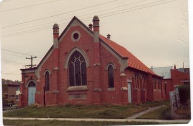
Slide, Former CBA Bank, Main Road, Eltham, c.1975, 1975c
Bought by the Methodist church c.1951, now Uniting Church and used for many years as an Opportunity Shop. Scene of an infamous bank robbery in December 194935 mm colour positive transparency Mount - Agfacolor Service (Blue)cba bank, commercial bank of australia, eltham, main road -
 Bendigo Military Museum
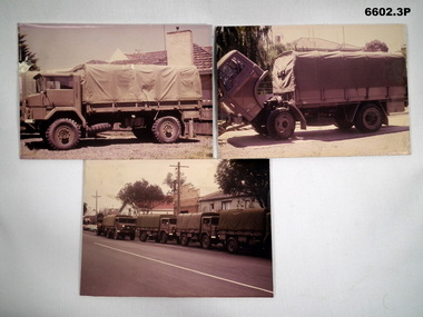
Photograph - PHOTOGRAPHS, TRUCKS FROM 1970's, RACT, 1970's
3. 2 trucks have the 3rd MD TAC Sign, 1 truck has the TAC sign with 7 on it. Passchendaele Barracks was the name of the Army Drill Hall, Mollison Street, Bendigo. The drill hall was in use 1916 - abt 2004.1. Side view of international MK3 Army Truck 4 x 4 set up for troop or general service work. Canvas cover is on. Coloured photo taken in the Mollison Street Depot yard. Photo is mounted on stiff cardboard. 2. Side View of Army Commercial Ford Truck. Cabin tilted forward to enable access to engine (Ford CL 400). 3. Group photo in colour, of 5 MN3 trucks lined up on the road beside the Mollison Street Drill Hall,. 1. On the rear is a 'stuck on' label "International 2 1/2 tons GS MN3 Bendigo Deport Yard". 3. On the rear is written "Convoy Inter MK3's in Mollison Street Bendigo. trucks, cmf, passchendaele barracks trust -
 Bendigo Military Museum
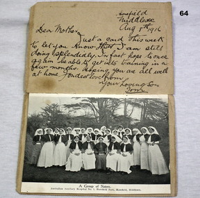
Card - PHOTO LETTER CARD, 08.08.1916
Contains pictures of nursing staff and patients at No 1 Australian Auxilliary Hospital 1914 - 1919. Tom will be Charles Thomas Chapman No 325, enlisted in E Coy 5th Batt AIF on 17.8.1914. Embarked for Egypt 21.10.1914 then for Gallipoli 5.4.1915. WIA 16.5.1915 GSW to upper extremities and hernia. Hospitalised England No 1 Aust Aux Hospital. Finally back to France 28.6.1917. Hospitalised 16.11.1917 with Tachy Cardia and then Laryngitis. Promoted Cpl 18.8.1918. Embarked for Aust 14.9.1918 transport duty (1914 men). Discharged 23.3.1919. Collection re Mrs May Burns.Letter card to Mrs C. CHAPMAN, Kyneton Road Heathcote, from her son Tom. Contains commercial photos of the Australian Auxilliary Hospital No.1 Harefield, Middlesex, England. Stamped: Australian Auxillary Hospital, Harefield, Middlesexdocuments, letters, cards, military history, hospitals -
 Flagstaff Hill Maritime Museum and Village
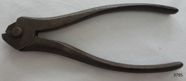
Tool - Pliers, Early 20th Century
In 1887 the long established steel toy business of Richard Timmins and Sons of Pershore Street Birmingham was sold to W C Wynn & sons, of Commercial Street Birmingham. They proceeded to extend their works and eventually concentrated on the amalgamation of both businesses under the name of Wynn and Timmins at the one address in Commercial Street. In 1892 they were incorporated as a Limited Company and by 1914 were known as the manufacturers of hand tools for all trades, iron and steel stampers, die sinker, and in the process of press working in sheet and metal for various items. The company around this time employed 200 people and the directors of the company in 1914 were W. H. Wynn, H. S. Wynn, W. L. Wynn. In 1929 they were producing tools under the heart brand until in 1969 the company was taken over by Balfour and Darwins of Sheffield, and the manufacturing facility in Birmingham was closed.An early manufacture of tradesman's tools, from 1900 into the late 1960s the company was a major suppler of tools to various industries and pioneered a number of improvements for individual hand tools for specific industries.Steel snub nosed pliers designed for a specific use unidentified at this time."WYNN & TIMMINS" stamped into the steel handle tools, pliers, metal pliers, wynn & timmins, birmingham manufacturer, tool manufacturer, richard timmins, sheet metal manufactures -
 Flagstaff Hill Maritime Museum and Village
Craft - Ship Model, Billings Boats Denmark Aps, Cutty Sark, 1980s
This ship model of the Cutty Sark was hand-built in the 1980s from a model kit produced by Billings, Denmark. It was on display in the Olde Maritime Motor Inn in Warrnambool until it was refurbished around 2015. The Cutty Sark was a famous clipper ship, launched in 1869 for the tea trade from China to London. The ship was designed for speed, with the ambition to be the fastest ship. In the late 1800s, it competed in the tea clipper races. It was eventually sold to a Portuguese company, Ferreria, and took on the company's name. It was sold again and renamed Maria do Amparo. Finally, the ship's name was returned to the original 'Cutty Sark' when it was purchased by Captain Dowman for use as a cadet training ship. The ship continued trading and in 1922 it became the last operating clipper ship in the world. The ship is now a museum, preserved in a dry dock at Greenwich, England, as part of the British National Historic Fleet. About Barry Williams: - The maker, Barry Williams, worked for the Australian Shipping Line, Huddart Packard Ltd., until it closed down in 1960. Williams then worked for Shaw Savill & Albion Co. Ltd., a substantial British passenger and liner company. and subsequently Furness Withy Ltd. (SS&A's parent company). In the late 1970s Williams and two friends established their own ship chartering company in Melbourne, the Harwood Shipping Co. During the early 1970s Williams and his wife lived in London, near Greenwich, and often walked along the river where the Cutty Sark Maritime Museum is located. The fascination of the Cutty Sark led Williams to build model ships of the same era. At one stage Williams lost the rigging plan for the Cutty Sark but one of his partners, on a visit to London, photographed the Cutty Sark on the river, and Williams used these to complete the rigging on the model. Williams found the making of the model a very demanding but also pleasurable exercise.The model is significant for showing a visual representation of one of the most famous tea clippers, the vessel Cutty Sark. The three-masted ship was built for speed and traded tea between England and China. In 1922 the Cutty Sark became the last operating tea clipper in the world. The craft of ship model building has been popular for centuries, especially with people associated with the sea, such as this model builder, whose career was based around the shipping industry.Ship model; clipper ship, the 'Cutty Sark', a three-masted clipper ship, bare rigging, netting below the bowspit, and fine chains hanging from the bowspit. Black hull with two parallel horizontal stripes below the rail. Lifeboats on board. The white figurehead is below the bowsprit. The model comes with a cradle stand. The ship's name is not visible on the model.flagstaff hill, warrnambool, shipwrecked coast, flagstaff hill maritime museum, maritime museum, shipwreck coast, flagstaff hill maritime village, great ocean road, cunysark, historic sailing ship, tea clipper, sail training vessel, cadet training ship, commercial trading vessel, cargo sail vessel, ship model cutty sark -
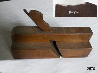 Flagstaff Hill Maritime Museum and Village
Tool - Moulding Plane, Charles Nurse, 1860-1900
The original Nurse family business began in 1841 in Maidstone Kent until 1861 where they were plane makers, moving to London in 1887 the company became C Nurse & Co. And continued until 1937 under that name at the (Invicta works). The majority of their plane making was done in London but there are Sheffield and Brighton marks on their tools as well. The company was not only wood plane makers but tool makers in general with the Charles Nurse & Co catalogue having 350 pages of tools for sale of varying types for different building trades and over 138 pages dedicated to woodworking tools. Records show that the company was at 182 Walworth Road London from 1887-1949. However, they had several retail outlets before this time and records indicate before 1887 Charles Nurse was at 32 Mill St Maidstone Kent, from 1844 -1860 but were in business before then. Also in Brighton at 135 Queens Road from 1865 -1871 and at 3 Mill Street Maidstone, again from 1872 - 1889 listed on records of the time as “plane and tool makers.”A vintage item made by a significant tool maker and retailer from the middle of the nineteenth century and into the first half of the twentieth century. These items were made commercially for firms and individuals that worked in wood and needed a tool that could produce an ornamental finish to timber. The tool was used before electric or mechanical routers or spindle moulders came into use. They were used by craftsmen to produce decorative mouldings by hand. These profiled planes came in various shapes and sizes. A significant tool that today is quite rare and sought after by collectors. It gives us a snapshot of how furniture and other decorative finishes were created on timber by the use of hand tools only. Moulding Plane a Casing Moulding Plane with two Scotia profiles Maker C Nurse and Co London. Owner A. E. NunnMaker C Nurse & Co & A E Nunn (previous owner)flagstaff hill, warrnambool, shipwrecked-coast, flagstaff-hill, flagstaff-hill-maritime-museum, maritime-museum, shipwreck-coast, flagstaff-hill-maritime-village