Showing 758 items matching " farm houses"
-
 Eltham District Historical Society Inc
Photograph, Liz Pidgeon, Heritage Excursion; The 1901 Eltham Railway Walk, 3 May 2014, 3 May 2014
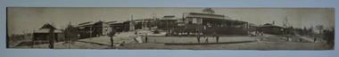
Newsletter No. 216, May 2014 May Excursion – The 1901 Eltham Railway Walk The railway from Heidelberg to Eltham was opened in 1902. Over the previous year railway construction cut a curving swathe through Josiah Holloway’s 1851 Little Eltham subdivision. The survey plans for the railway show the owners and occupiers of land within Little Eltham affected by the railway alignment and for some distance each side. The plans show houses and other buildings but development at that time was rather sparse. Copies of these plans from the State Library of Victoria collection have been provided to the Society by Alan Sheehan. For our walk on 3rd May we intend to follow the railway from the Eltham Station to Ryans Road, which was the boundary of the adjoining Montmorency Farm. The return will be by way of nearby streets. Along the way we will discuss the details shown on the railway plans as well as more recent railway documents and photographs. At the conclusion and if time permits we can inspect the historical display at the Eltham Station. The walk is about 3 km in length and will take about 2.5 hours. It will start at 2 pm at the Eltham Railway Station car park (east/Main Road side) (Melway Ref. 21 J5).Born Digitalheritage excursion, activities, eltham district historical society, eltham railway station, eltham library, trestle bridge -
 Eltham District Historical Society Inc
Photograph, Liz Pidgeon, Heritage Excursion; The 1901 Eltham Railway Walk, 3 May 2014, 3 May 2014
EDHS Member Doug Orford stands by a yarn bombing installation. ewsletter No. 216, May 2014 May Excursion – The 1901 Eltham Railway Walk The railway from Heidelberg to Eltham was opened in 1902. Over the previous year railway construction cut a curving swathe through Josiah Holloway’s 1851 Little Eltham subdivision. The survey plans for the railway show the owners and occupiers of land within Little Eltham affected by the railway alignment and for some distance each side. The plans show houses and other buildings but development at that time was rather sparse. Copies of these plans from the State Library of Victoria collection have been provided to the Society by Alan Sheehan. For our walk on 3rd May we intend to follow the railway from the Eltham Station to Ryans Road, which was the boundary of the adjoining Montmorency Farm. The return will be by way of nearby streets. Along the way we will discuss the details shown on the railway plans as well as more recent railway documents and photographs. At the conclusion and if time permits we can inspect the historical display at the Eltham Station. The walk is about 3 km in length and will take about 2.5 hours. It will start at 2 pm at the Eltham Railway Station car park (east/Main Road side) (Melway Ref. 21 J5).Born Digitalheritage excursion, activities, eltham district historical society, eltham railway station, eltham library, trestle bridge, yarn bombing, doug orford -
 Eltham District Historical Society Inc
Photograph, Liz Pidgeon, Heritage Excursion; The 1901 Eltham Railway Walk, 3 May 2014, 3 May 2014
Newsletter No. 216, May 2014 May Excursion – The 1901 Eltham Railway Walk The railway from Heidelberg to Eltham was opened in 1902. Over the previous year railway construction cut a curving swathe through Josiah Holloway’s 1851 Little Eltham subdivision. The survey plans for the railway show the owners and occupiers of land within Little Eltham affected by the railway alignment and for some distance each side. The plans show houses and other buildings but development at that time was rather sparse. Copies of these plans from the State Library of Victoria collection have been provided to the Society by Alan Sheehan. For our walk on 3rd May we intend to follow the railway from the Eltham Station to Ryans Road, which was the boundary of the adjoining Montmorency Farm. The return will be by way of nearby streets. Along the way we will discuss the details shown on the railway plans as well as more recent railway documents and photographs. At the conclusion and if time permits we can inspect the historical display at the Eltham Station. The walk is about 3 km in length and will take about 2.5 hours. It will start at 2 pm at the Eltham Railway Station car park (east/Main Road side) (Melway Ref. 21 J5).Born Digitalheritage excursion, activities, eltham district historical society, eltham railway station, eltham library, trestle bridge -
 Kiewa Valley Historical Society
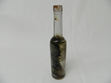
Bottle - Chemist, Pre 1915
... the walls of a Tawonga South farm house having been left there when ...This bottle contained castor oil or cod-liver oil and has a hand finished top. It would have been bought at a local chemist or in a larger city on a shopping expedition.Historical: Found inside the walls of a Tawonga South farm house having been left there when the house was being built. Change of bottles - shape, glass stopper, manufacture and use. Aesthetic: Display showing shape and colour due to the affect of sunlight.Clear glass bottle with manganese/purple tinge caused by sunlight. Hand finished top. Joins in glass on each side but not continuing to opening. Straight sides from the base to a little more than half way up. Sharp taper to neck which is straight and long to lip and opening. Cork stopper.Bubbles in glass. chemist, castor oil, codliver oil, tawonga south, aurora parmesan -
 Kiewa Valley Historical Society
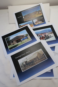
Coloured photographs on paper - Back to Tawonga 2010
These photos were collected and copied by Di Edmondson for the 'Back To Tawonga' Event in 2010 when she launched her book "Tawonga Remembers".An historical photographic collection of Tawonga and its surrounds, places and people up to 20101. Saw Mill - Mill house 2. The Rock Pool 3. People at the Rock Pool x 2 4.Old Saw mill 5. Back to Tawonga Celebrations x6 6. Tennis Curts opposite the Tawonga Store, Bakery in the background 7. Bowling Club 8. Old Guide Hall 9. The Old Boarding House 10. Old Fire Brigade Shed 11. Building the New Tawonga Memorial Hall 12. Tawonga Go Kart Track - 1960s 13. Tawonga Pony Club 1969 State Championships 14. Tawonga Recreation Reserve Newspaper article 15. The Damm Children 19. 1980s Brian Edmondson, Geoff Edmondson, Mick Harvey, David Piera. Geoff Edmondson's car 20. Tawonga Speedway Track - 1970s Mick Harvey and Paul Harkin's car 21. 2000 22. Tawonga Sports Vera Ryder and Allie Briggs 23. Tawonga School Photos x8 24. Harry Cooper's Farm Looking South 25.View from Edmondson's Farm - looking north 26. Mount Emu 27. St Aiden's Debutante Ball 27. Grand Opening Ball 1961 Tawonga Hall 28. The Kiewa Valley Road at Tawonga. Vic. 29. Tennis Courts opposite the Bogong Hotel 30.Opening of the new Toilet Block in Pioneer park 31. Old Tawonga Store x 3 32. Tawonga Memorial Hall 33. Anglican Church, St Aiden's x 2 34. Motor Khana held at Recreation reserve 35. 1970 State Champioships Team 36. Kiewa Valley School Sports at Dederang 37. Miscellaneous photos x27 Some photos have headings and some headings have been writtentawonga remembers, back to tawonga 2010, di edmondson -
 Kiewa Valley Historical Society
Photos - King Family Collection
... farm. Later when a house became available, we moved into Valley ...The King family lived in Tawonga South where my older brother and sister went to school. We lived over the road from Wally Madison's farm. Later when a house became available, we moved into Valley Avenue, Mt Beauty. This is when I turned 5 and started my schooling. It was a long walk for a 5 year old as I remember. Then later we moved to 50 Lakeside Ave. I remember we loved living there as it was close to the school, footy ground and kindergarten. My father, Ted King, wad a carpenter and was involved in the building of many houses in Mt Beauty which was the home for the workers on the Kiewa Electric Scheme. So as they are part of the history of Mt Beauty I thought they may be useful to you as part of the history. The tennis photos, I vaguely remember Lou Hoad and Ken Rosewell giving exhibition matches in Mt Beauty. I may stand corrected on this, but I do remember my parents who were keen tennis players themselves were most excited at seeing these famous tennis players. As I was only 9 when we left Mt Beauty to live in Dimboola I still remember the shock of leaving a beautiful mountainous county side and arriving in a flat farming land next to a desert and seeing windmills One thing I do remember from school is, once a week (or fortnight) the teacher used to come around with a jar of little white pills, of which we were all to take. I really don't know what they were?? or for?? I also remember being taught to swim in the freezing cold river by a Mrs Smith who wore black bathers and wore her hair in a bun...... ...I am now in my 70s My father used to also carve intricate trays and jewellery boxes in his spare time. I think they were used for tennis trophies. by Diane Werner.x33 photos of small black and white photos of the Tawonga, Tawonga South and Mt Beauty - Photos not labelled but described as follows. See each photo for a possible label. A. Tawonga? B. Mt Beauty taken on the road to Bogong ? C. SEC Works D. Industrial buildings with mountains in the background E. Building site with wooden frame and 3 men F. Buildings with power poles G. Building site with lots of huts H. Buildings under construction I. Group of houses in the distance J. Group of houses in the distance K. Group of people in front of a building L. Group of 8 men sitting on timber planks, corrugated iron at back. M.& N. Building site with floor and upright timbers O. Mountain view with camp site in foreground P.& Q. Buiding site, several houses R.5 men at a building site S. portable building on trailer T & U. Mountain view V. Building site W. Group of men, car and mountains in background X. Cows Y. Pigs Z. 2 men standing next to cars. AA. Football players BB. Man painting a corrugated iron building CC. Football DD. Men in front of a building EE Buildings with mountains in background FF & GG Tennis payersHH & II. Electricity infrastructure -
 Kiewa Valley Historical Society
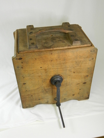
Churn Butter - Wooden
... mechanistically made. Many houses or small farms in the Kiewa Valley had ...This type of butter churn was used around the early to mid 20 century by household and small farms of the Kiewa Valley who kept cows for Milk. The buy product of the milk was cream and butter. Once the cows had been milked, often by hand, women would place the milk in shallow dish, and next morning the cream would be separated from the milk. Or a cream separator machine would be used. The cream would then be churned by the paddles in the butter churner until it formed in butter clumps. Butter Pats would be used to take the butter out and press into triangle butter blocksThis butter churner is significant due to its historical value which explains how butter was made by hand before this process became mechanistically made. Many houses or small farms in the Kiewa Valley had these butter churns to make their own butter for their household or to sell. This has very good interpretation significance as it adds to the history of dairy industry in the Kiewa Valley. Wooden box with a metal handle for turning the blades /paddles /slats inside the box.These blades churn the cream when the handle is turned. There is also a wooden handle and a wooden lid.butter, dairy, milk, manual, domestic, item, food, preparation, dairying, technology -
 Eltham District Historical Society Inc
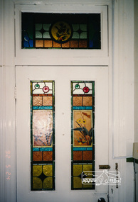
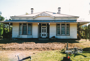
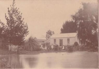
Photograph, Edendale Farm, May 1992, 1/5/92
... Three colour photographs of the house at Edendale Farm... photographs of the house at Edendale Farm, including leadlight windows ...Three colour photographs of the house at Edendale Farm, including leadlight windows and chandelier.edendale, houses, elham, gastons road -
 Eltham District Historical Society Inc
Photograph, Edendale Farm, Eltham
... Four colour photographs of the house at Edendale Farm... melbourne edendale farm eltham gastons road houses Four colour ...Four colour photographs of the house at Edendale Farm, Gastons Road Elthamedendale farm, eltham, gastons road, houses -
 Warrnambool and District Historical Society Inc.
Medal, Campaign Stars & Medals, C 1945
This medal was awarded to Ernest Henry Swan. He served from December 1941 to July 1942 in the Citizen Military Forces and from July 1942 to September 1944 in the Australian Imperial Forces. His reason for discharge was reserved occupation. He held the rank of corporal in 26th Motor regiment. He was born in Colac 19/11/1919 to Ernest Swan and Daisy Johnson. He died 04/08/2009 and is buried at the Warrnambool cemetery. During his life he farmed a soldiers’ settlers block in the Grasmere area, north of Warrnambool.A common item which relates to a local soldier and World War 11.Round white metal medal with bar at top. Australian Coat of arms on front with image of George 6th on the reverse. Flat edge on medal with recipient's name and number engraved. it is housed in small cream card box with a small sheet of paper with summary of conditions of campaign stars and medals. The Australian Service medal 1939-1945. George VI G Br OMN Rex Et Indiae Imp VX88010 E H Swanwarrnambool, ernest henry swan -
 Emerald Museum & Nobelius Heritage Park
Photograph, Emerald Police - Constable Fleming
FLEMING, Lawrence Joseph, (b.1876 - d. 1967) Police Reg. No. 5974 served with the Emerald Police from 08/11/1915 - 06/09/1934 as 1st. Constable. Lawrence Joseph Fleming was a veteran of the Boer War. He came to Emerald after his discharge from the Australian Army. He joined the police force, travelling on horseback to cover an area from Gembrook, Cockatoo and Emerald, through to Monbulk and Belgrave. His house which also served as the police station still exists in Kilvington Drive, Emerald. The back yard contained a lock-up for prisoners. He served as a policeman in Emerald for 19 years. When he retired, around 1928 - 30, Constable Fleming bought the Collis farm in Pinnocks Road, which at the time extended right down to Telopea Road. He died in Ferntree Gully hospital at the age of 91 years on the 12 June 1967. (as researched by C. Britton)A rare photograph of 1st Constable Lawrence Joseph Fleming - Emerald PoliceCopy of photograph depicting Constable Fleming on horseback MonbulkOn back, handwritten: 'Constable Flemming at Bayne's bridge Monbulk (please note incorrect spelling of Fleming. emerald police, lawrence joseph fleming -
 Emerald Museum & Nobelius Heritage Park
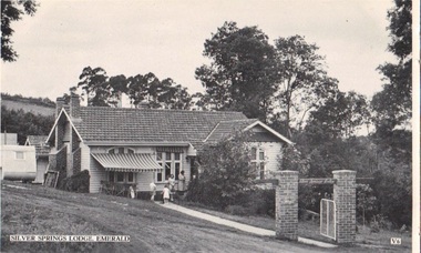
Postcard - B/W, Silver Springs Lodge, Emerald, circa 1949-50
Silver Springs Lodge, Emerald, was owned and managed in the 1940s-1950s by William and Olive Hamilton. It offered Pianola, Radio, Swimming, Tennis, Riding, Golf, Farm Produce, Home Cooking, coke fires, continuous hot water and was sewered. Weekly Tariffs were ₤4-10-0 and ₤4-15-0. Mrs Hamilton served as official photographer for Royal visits.The Lodge was an early tourist enterprise in the region, and located in a particularly admired area.B/W postcard photo issued by Valentine's, showing front gate and part profile of Silver Springs Lodge, Emerald. Caravan visible to left, and five people visible around the front door. Arch over front gate bears legend "Silver Springs Lodge".FRONT: Silver Springs Lodge, Emerald V6 REVERSE: Valentine's POST CARD A GENUINE PHOTOGRAPHsilver springs lodge, hamilton, guest houses, valentine's -
 RSL Victoria - Anzac House Reference Library and Memorabilia Collection
Diary of William Augustus Elverd, William Augustus Elverd, Written retrospectively (?). 1915 to 1919
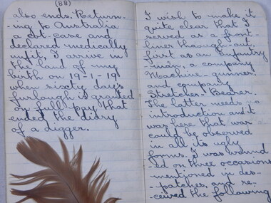
Diary details action seen at Gallipoli, Pozieres, Mouquet Farm and Passchendale. Diary may have been written (much?) later than experiences described. Incomplete, coverless notebook - commences at part of page 4, complete from page 5 onwards. Diary of William Elverd (1995 - 16th Battalion, 5th Reinforcement).ww1, western front, diaries, william augustus elverd, 16 battalion -
 RSL Victoria - Anzac House Reference Library and Memorabilia Collection
Photograph, Macleod Repatriation Sanitorium, circa 1914
The former Mont Park/Bundoora Psychiatric and Repatriation Hospitals Complex consisted of seven hospitals on a site of 185 hectares. The site comprising the Mont Park and Strathallen estates was consolidated by the Victorian government by purchase and transfer from the Closer Settlement Board in 1909 . The Mont Park Hospital commenced in 1910 with the building of the Farm Workers Block . In 1912 the landscape gardener Hugh Linaker was employed to layout the grounds of Mont Park and other State mental hospitals. The other hospitals were gradually split off from the Mont Park administration to form separate entities included among these was the Macleod Repatriation Hospital (1915), An agreement was made with the Defence Department in 1914 for the latter to erect the Mont Park central block (the "Chronic Wards") for use as a Military Hospital, and for it later to revert to the State as portion of Mont Park Hospital. The buildings now known as the Chronic Wards were completed in this way in 1916 and used as the Australian General Hospital no. 16 for the duration of the war. One wing of this building was set aside for mental patients during this period. Silver gelatin photographww1, macleod repatriation sanitorium, mont park -
 Eltham District Historical Society Inc
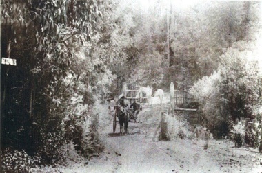
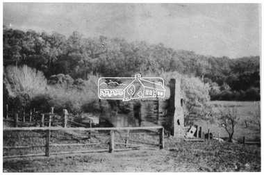
Photograph, Old House on Allwood farm at Hurstbridge, 1954, 1954
... Old House on Allwood farm at Hurstbridge, 1954.... collection hurstbridge cottage allwood Digital image Old House ...Small old abandoned cottage in rural setting on the Allwood farm at Hurstbridge. This photo forms part of a collection of photographs gathered by the Shire of Eltham for their centenary project book, "Pioneers and Painters: 100 years of the Shire of Eltham" by Alan Marshall (1971). The collection of over 500 images is held in partnership between Eltham District Historical Society and Yarra Plenty Regional Library (Eltham Library) and is now formally known as 'The Shire of Eltham Pioneers Photograph Collection.' It is significant in being the first community sourced collection representing the places and people of the Shire's first one hundred years.Digital imagesepp, shire of eltham pioneers photograph collection, hurstbridge, cottage, allwood -
 Eltham District Historical Society Inc
Photograph, View at Eltham, Vic, c.1924
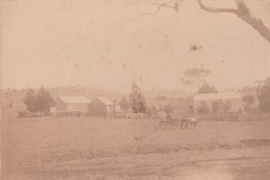
Copy of possible Rose Stereograph Co. postcard “View at Eltham, Vic.”, c.1924 looking southwest from Main Road near York Street to Bridge Street and the original 1875 bridge across what is now the Alistair Knox Park The land in the foreground was first bought from the Crown by J.M. Holloway in 1851. The land was sub-divided and called "Little Eltham". Bridge Street was created as part of the sub-division. Most of the sub-division was residential lots but the creek valley was divided into lots for small farms. Council started to buy the land for the Eltham Town park in the early 1960s. The area was used as a garbage tip and filled above the flood plain of the creek. Development of the land for a park began in the early 1970s. The house on the right was owned for many years by the Hill family until Council bought it in the early 1960s. The house was built in the 1850s or 60s. The house on the left stood on what is now the southwest corner of Susan and Bridge Streets. The Braithwaite family was associated with this house. The double line of fencing in the foreground was a continuation of York Street to the creek. The Bridge Street bridge was built in 1875 and replaced in 1958. (Ref: Early view of Little Eltham; Byways of History by Colleen Ison, Publication unk, 24 August 1982) Reproduced on p61 of 'Pioneers & Painters' Date estimated on same as View at Hurstbridge featuring Wattle Valley EstateThis photo forms part of a collection of photographs gathered by the Shire of Eltham for their centenary project book,"Pioneers and Painters: 100 years of the Shire of Eltham" by Alan Marshall (1971). The collection of over 500 images is held in partnership between Eltham District Historical Society and Yarra Plenty Regional Library (Eltham Library) and is now formally known as the 'The Shire of Eltham Pioneers Photograph Collection.' It is significant in being the first community sourced collection representing the places and people of the Shire's first one hundred years.Digital image 120 format B&W negative Prints 17 x 25 cm and 10 x 15 cmsepp, shire of eltham pioneers photograph collection, eltham, bridge street, bridge, alistair knox park, braithwaite, bridge street bridge, eltham town park, hill family home, main road, pioneers and painters, york street -
 Cheese World Museum
DVD, On our selection: the women's story
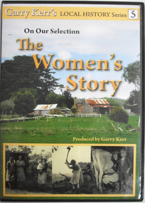
This is the story of the women of the bush, women who performed more than the traditional duties of wife and mother. They worked alongside their men, through good/times and bad and they were rare to complain. Six former country women of the Portland/Heywood district provide us with a snapshot of life as it was from the 1920's through to the 1960's. They speak about their own and their mother's lives, lives which have experienced the greatest material and personal changes in history. The story of the 'Remarkable Mary Stuchbery' details the struggles of a wife and family whose husband/father contracted polio shortly after returning from WWII service. Garry Kerr has produced a series of local history stories, initially for the Heywood [history group] and more recent items privately.The material contained in these interviews provides a first-hand insight into the experiences of women who were involved in carving farms from virgin bush. Their recollections of work, social activities and opportunities for their children are an invaluable primary source.Full colour DVD cover featuring image of old hip-roof weatherboard house with front verandah and skillion roof to rear with stone chimney attached to outside. Corrugated iron roof is rusty. To the left is an outbuilding. Picket and wire fencing is in the foreground, background has large cypress tree to left and gum to right. At the bottom is a series of three black and white images showing (L-R) three women in working clothes and a woman holding a baby; woman chopping wood; woman milking cow with young boy standing beside her. The back cover is yellow with images of the seven women featured showing coloured images of the interviewees beside black and white images of the interviewees when young. DVD features the same images as the front cover.Garry Kerr's LOCAL HISTORY Series 5/On Our Selection/The/Women's/Story/Produced by Garry Kerr (front) WOMEN WERE THE UNSUNG HEROES OF THE BUSH/This is the story of the women of the bush [see historical information] ... Running time 74 minutes/Plus an additional 30 minutes of/'The Remarkable Mary Stuchbery' -
 Learmonth and District Historical Society Inc.
Photo, "Willow Vale" Waubra, "Early 19th Century
The photo shows the Harrison family out the front of their home in Waubra, Victoria, called "Willow Vale".Photo of "Willow Vale" farm at Waubra, Victoria"Willow Vale", home of Christopher & Selina (nee Smith) Harrison family from Waubra, Victoria. This is a sepia photo with cardboard backing showing the Harrison family in front of the house. 21 & 1/2 cms wide x 16 & 1/2 cms high."Willow Vale" Waubra. Home of Christopher & Selina Harrison. -
 Learmonth and District Historical Society Inc.
Photo, "Willow Vale" Waubra, Victoria, Late 19th Century or Early 20th Century
It show the farm "Willow Vale" Waubra that was once owned by the Christopher and Selina (nee Smith) Harrison family who once lived on this farm and whoes descendants continue to live in the same area today.A very pale sepia photo of the "Willow Vale" farm at Waubra, Victoria that was owned by Christopher and Selina (nee Smith) Harrison. It shows a horse and buggy, along with the main house/houses and out buildings with what look like it could be a slightly dry dam at the bottom of the photo.Nil -
 Marysville & District Historical Society
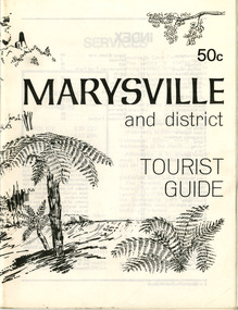
Booklet (Item) - Tourist guide, Ian and Danese Walshe et al, MARYSVILLE and district TOURIST GUIDE, 1982
A tourist guide outlining services, accommodation, activities and places of interest to visit in and around Marysville and the local district.A tourist guide outlining services, accommodation, activities and places of interest to visit in and around Marysville and the local district.marysville, victoria, australia, tourist guide, marysville hotel, castles' store, hawthorne's corner shop, tudor lodge, black spur motel and caravan park, buxton general store, golden fleece roadhouse, marysville garage, burrengeen park, lake mountain, steavenson falls, nanda binya lodge, alpenglow nursery, black spur inn hotel, silver stream trout farm, mccfarlane's grocery, barton's drapery, marysville newsagency, eildon explorer, beauty spot nursery, crossways, pumpernickel, mckenzie's tourist services, blue hills riding school, mountain view horse hire, pitt's garage, maryton park, j l gould sawmill, eildon deer park, eildon weir, maroondah dam, snob's creek, healesville sanctuary, graceburn park, cathedral range, beauty spot walk, tree fern gully walk, michaeldene track, keppel track, woods lookout track, cumberland scenic reserve, cambarville, the big tree, cora-lyn falls, barton's lookout, cumberland falls, sovereign view, wirreanda festival, scenic motel, tower motel, marylands guest house, kooringa guest house, marylyn guest house, mountain lodge, el kanah, marysville hotel motel, buxton hotel motel, black spur inn, buxton caravan park, marysville caravan park, the cumberland, marysville recreation and fun park -
 Marysville & District Historical Society
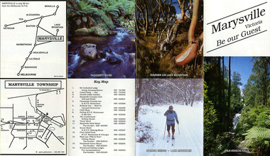
Booklet (Item) - Leisure guide, Michael Chesire & Associates Pty. Ltd, MARYSVILLE & DISTRICT LEISURE GUIDE-AUTUMN/WINTER, 1986, 1986
A free leisure guide to Marysville and the surrounding district published for Autumn and Winter, 1986. This was produced by Michael Cheshire as a free publication to promote tourism in Marysville and the surrounding district. It includes maps of the Big River Valley, Cumberland Valley, Lady Talbot Forest Drive, the Marysville area, and the township of Marysville. It was released in the autumn of 1986 and was sponsored by the Marysville Tourist & Progress Association. The Association was formed in November 1907 to promote tourism within the area. This included the physical creation of signage, parklands, roads, and walks to various attractions. A free leisure guide to Marysville and the surrounding district published for Autumn and Winter, 1986.marysville, victoria, australia, leisure guide, michael cheshire & associates pty ltd, marysville golf club, blackwood lodges, sir colin mackenzie fauna park, lake eildon, fraser national park, yarra valley wineries, marysville coach tours, kooringa, marylands guest house, lady talbot forest drive, wishing well, taggerty river recreation area, athols abbey, phantom falls, keppel falls, the beeches walking track, marylyn guest house, kufstein inn motel, the cumberland, marysville tourist & progress association, marysville newsagency & general store, crossways restaurant & motel, beauty spot walk, tree fern gully walk, michaeldene track, keppel track, woods lookout track, marysville hotel motel, lake mountain ski hire, marysville recreation and fun park, mytanta horseback safaris, upper big river valley, the big culvert, marysville mountain view horse hire, maryton park, amber view holiday lodges, cathedral restaurant, the top shop, tower motel, menzes garage, beauty spot nursery, marysville ski hire, lake mountain ski school, faraway forest, scenic motel, buxton trout farm, marysville hardware, timbertop steakhouse, marysville trout farm, healesville sanctuary, buxton hotel motel, nanda binya lodge, buxton antique and furniture mart, the black spur inn hotel, alexandra, lake mountain, geoffrey pope & associates -
 Marysville & District Historical Society
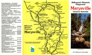
Ephemera (Item) - Tourist Guide, Marysville Tourist Association, Marysville Victoria Be our Guest, Unknown
... scenic motel fruit salad farm marylyn guest house marylands guest ...A fold out tourist guide to Marysville and the surrounding district. This map was produced by the Marysville Tourist Association.A fold out tourist guide to Marysville and the surrounding district.marysville, victoria, australia, tourist guide, steavenson falls, mt cathedral lodge, camelot camel farm, danish coffee garden, marysville country club, crossways country inn, kufstein inn, marysville craft shop, gallery restaurant, the cumberland, tower motel, marysville hotel, scenic motel, fruit salad farm, marylyn guest house, marylands guest house, blackwood lodges, taggerty river, lake mountain -
 Marysville & District Historical Society
Ephemera (Item) - Tourist Guide, Melbourne's Mountain Playground Marysville Victoria Australia, Unknown
A fold out tourist guide to Marysville and the surrounding district.A fold out tourist guide to Marysville and the surrounding district.marysville, victoria, australia, steavenson falls, marysville golf club, cathedral range, blackwood holiday flats, cumberland holiday inn, kooringa conference and holiday centre, marylyn guest house, marysville caravan park, marysville hotel motel, nanda binya lodge, scenic motel, tower motel, cathedral restaurant, chris's place, danish coffee garden, tudor lodge roadhouse, buxton trout farm, silverstream trout farm, lake mountain ski hire, marysville fun park, mountain view horse hire, jl gould sawmills, marysville dairy, marysville drapery shop, marysville garage, marysville newsagency, top shop