Showing 1919 items
matching flood
-
 Kew Historical Society Inc
Photograph, Marnie McLeod, Floods on the River Yarra at Kew, 1916
The donation was accompanied by the following letter from the donor: "Hi. I found these in with family photos. Taken by family as Mamie McLeod was living in Fellows Street, Kew, so would be near there. Retain (or discard) as you see fit." [Donor's name and address withheld from public view]. To gain an insight into the flood levels at Kew, it is worth reading newspaper accounts of the event. The Age published an article - Valuable Gardens Destroyed at Kew - on 25 September 1916: "VALUABLE GARDENS DESTROYED AT KEW. From the heights of Studley Park, Kew, a splendid view of the flood waters can be obtained, and yesterday afternoon, despite continuous rain, crowds of citizens assembled there to witness the spectacle. There is a vast stretch of water some 300 or 400 yards broad, above the foot bridge connecting Gipps-street, Collingwood, and Studley Park. The river is only about 3 feet from the top of the embankment connecting with the ramp of the bridge on the Studiey Park side. When the upper llood waters come down it is almost a certainty that tne embankment will be submerged and the bridge rendered impassible. Below the bridge the waters again stretch out, and have submerged all the low-lying land on the Collingwood side and invaded the back premises ot the Kodak Co., Phoenix Biscuit Factory, a tannery adjoining thereto, the Shamrock Brewery, and Chinese gardens in the vicinity. At Walmer-street-bridge, at the end of Studley Park, the low-lying land on the Kew side is covered with water to the depth of many feet. Tlie land in question is owned in a great part by Mr Frank Lavers who haa gone in for intense culture on a pretty liberal scale on both the slopes of the hill and on the river flat. On the latter he is cultivating many acres of asparagus, and has at a considerable cost spent three years in preparing the ground and installing an irrigation system, reticulated from the Yan Yean water supply. This year the asparagus was put down, and the plants were in a promising condition. Tlie flood waters are now flowing fast over the land. The crop is ruined, and three years' work and expenditure destroyed. Mr. Laver's private residence fortunately is high above flood level, but two houses he owns off Young-street have been flooded out. Having been warned in time, the tenants removed their furniture hefore the water came down to Mr. Laver's residence, where they themselves have been given accommodation in the meantime. All the river flats in East Kew are under water. One or two low-lying houses have been flooded. Chipperfield's boat shed at Willsmere is nearly covered, and some Chinese gardens in the vicinity are several feet under water."This, and the other three photographs donated of floods in Kew are believed to be the earliest in the collection. Together with our original MMBW River Yarra map showing flood levels, these items, when compared allow researchers to gain a visual perspective of the extent of the flood in 1916. Panoramic view, believed to be looking north towards Fairfield from the Zig-Zag Bridge on the River Yarra. The inscription on the reverese identifies it as taken before 1920.Inscription on reverse in ink "(pre 1920) Flood from Zig-zag bridge Yarra River, Kew Vic."river yarra, kew, floods 1916, zig-zag bridge -
 Kew Historical Society Inc
Photograph, Floods in North Kew, 1971
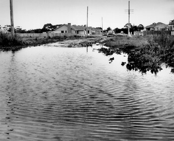
Living with natural processes was frequently a challenge to early European settlers and later residents of what was in the 1850s administered by the Borondara Road Board. This was compounded by the area being bounded on three sides by rivers (Yarra River, Koonung Creek and Gardiner's Creek). In 1849, the historian James Bonwick recorded that "our district [Kew] suffered considerably. Mr Wade speaks of 80 acres, out of 100 acres of his cultivated paddock, covered by water." Newspapers continued to describe major flooding in Kew in 1863, 1869, 1878, 1880, 1889, 1891, 1916 and 1934. While the construction of the Upper Yarra dam in 1957 reduced the levels of flowing downstream, local and riverine floods continue.The Kew Historical Society's pictures and map collections testify to the impact of flooding in the district. They have historical importance in documenting the extent of flooding in the district and its affects on homes, services and recreation. Numerous photographs record flooding throughout the Twentieth Century.Floods in North Kew, 1971. Looking northeast towards Kilby Road from River Avenue. Annotation on reverse: map and date "8 Nov. 71 10.30am".floods (kew), yarra river, kew flood, kilby road flood -
 City of Kingston
Photograph - Black and white, c. 1958
This photograph depicts flooding of Ozone Avenue in Beaumaris, located off Balcombe Road. Roads in the Beaumaris area lacked sufficient drains to clear surface water. In many cases streets were unsealed and without footpaths and some were dirt tracks. Gutters and road surfaces were made of clay and in the wetter months of winter, unsealed roads and tracks became impossible quagmires that were unnavigable for vehicles and pedestrians. In the first decade after World War II there was rapid expansion in construction of new houses in the suburb of Beaumaris. Utilities and infrastructure to support the growth of housing was inadequate and not provided for prior to the development of the area. Without rudimentary drainage, flooding was frequent. Storm water runoff, domestic sullage and septic tank overflow would form large pools and families were sometimes marooned within their homes. The frequent flooding caused isolation and hardship and residents endured difficulties with accessibility to facilities. These disadvantages had the potential to cause social issues for the new residents.Black and white photograph of flooding in Ozone Avenue, Beaumaris. The image shows floodwaters with boggy and rough terrain on an unsealed road with housing in the distance.Handwritten in blue ink: 2124 circled Handwritten in red ink: 80% Handwritten in blue ink on yellow Post-It note: Chap 6. underlined, 2194 Ozone Ave Beaumaris 1958beaumaris, ozone avenue, balcombe road, flooding, roads, infrastructure -
 Port Fairy Historical Society Museum and Archives
Photograph
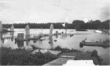
1946 was the year of the biggest flood experienced in Port Fairy. This photograph shows evidence of the inundation at the Port Fairy Cemetery situated at the West of the townBlack and white photograph of headstones surrounded by waterflood, river, 1946, headstone -
 Eltham District Historical Society Inc
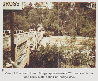
Work on paper (Sub-Item) - Photograph, Flooding, View of Diamond Street Bridge, Eltham 8 April 1977
Colour photograph. Flooding of Diamond Creek at Diamond Street Eltham bridge approximately 2 1/2 hours after the flood peak. Note debris on the bridge deck. 8 April 1977. flood, diamond creek, flooding, eltham, diamond street, bridge -
 Port Fairy Historical Society Museum and Archives
Photograph
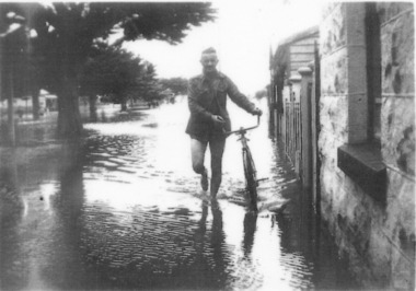
evidence of the 1946 floods in Bank Street outside the Keats house in Port Fairy Black and white photograph of Male walking a bicycle on footpathflood, river, bank street, 1946, keats -
 University of Melbourne, Burnley Campus Archives
Photograph - Black and white print, Series 6.18
Series 6Lagoon Paddock flooded.lagoon paddock, floods, james leslie provan, j.l. provan -
University of Melbourne, Burnley Campus Archives
Photograph - Black and white print, 6/18, 1947
Lagoon Paddock flooded. lagoon paddock, floods, e. m. gibson collection -
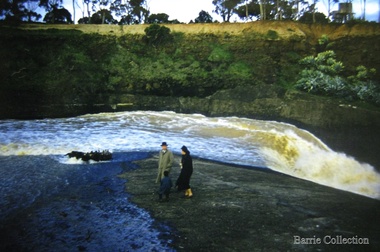 Melton City Libraries
Photograph, Melton Weir, 1961
Family at the spillway in floodmisc. -
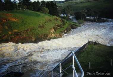 Melton City Libraries
Photograph, Melton Weir, 1961
Family at the spillway in floodmisc. -
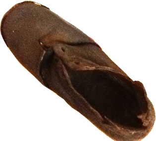 Warrnambool and District Historical Society Inc.
Footwear - Child's boot, 1940s
This small shoe (or boot) was found at Rosebrook, a small settlement between Warrnambool and Port Fairy, after the 1946 Western District floods. These floods are regarded as the worst in the history of European settlement in the Western District. At least five lives were lost, many small settlements and towns were isolated resulting in food shortages, onion and potato crops were ruined, 20 bridges were destroyed or damaged, roads were swept away, hundreds of farm animals perished and road and rail services were disrupted. The floods were the result of a very high rainfall in five successive days (658 points of rain in one 24 hours) and there was more flooding a week after the first major impact of the rains. A link to a major weather event in the South west.This is a small child’s brown shoe made of leather with a lace-up upper part (no laces) and a leather sole. The sides of the upper part of the shoe have broken away at the edges. As the shoe has been water-logged (it was found after the 1946 Western District floods) it has become hard and brittle. warrnambool, rosebrook western district floods, 1946, 1940's shoe -
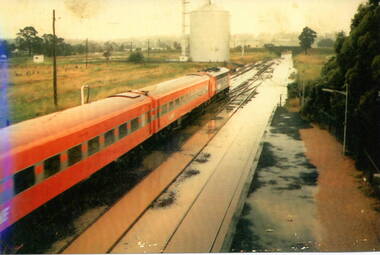 Sunbury Family History and Heritage Society Inc.
Photograph, 17 December 1985
On 17th December 1985 record torrential rain fell in Sunbury, which flooded the main Melbourne Bendigo rail line and disrupted traffic. The photograph is looking to the north of the station and takes in the historic Macedon Street bridge and the open ground with the storage silo on the west side of the railway line. A coloured photograph of a former V Line train stopped at a station where the railway line has been flooded. A storage silo occupies vac ant ground adjacent to the railway line.sunbury railway station, storage silos, horne street -
 Orbost & District Historical Society
black and white photographs, 1950s
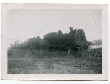
Dudley Charles Seymour Courtney , with a fellow worker, was trapped on the Orbost Raailwaay Station roof until rescued by an army duck. These photographs were his. He worked on the railway in Orbost from 1942 - 1952 approximately. During the 1952 flood nearly half of Orbost rail way station is washed away. The stationmaster and four members of his staff were rescued by police using army ducks.This is a pictorial record of a significant event in the history of Orbost.Nine small black / white photographs of a derailed train at a railway station. Derailed trucks and floodwaters can be seen. The photographs have a narrow white frame. Some are portrait and others landscape.on back of 3082.8 - hand-written in blue pen :"The floods worked the line from under the trucks in a couple of hours"floods-orbost orbost-railway-station rescue courtney-dudley-charles-seymour -
 Orbost & District Historical Society
May 1900
This is a photograph of the original Orbost / Snowy River Bridge , a suspension bridge which opened in 1893. It has been taken when the Snowy River was in flood. It is similar to other photographs held in The State Library, Victoria. The Snowy River Mail and Tambo and Croajingolong Gazette Sat 12 Aug 1893 records the opening of this bridge as "the most important public event that has yet been commemorated in Eastern ......The Messrs McLeod, with whom the first settlement of this district is generally associated, took up their residence on the eastern bank of the Snowy River about the year 1841 or 42. The late Mr W. Roadknight and Mr T. T. Stirling took possession of the territory on the western side of the Snowy about 35 years ago. During the occupation of the country by cattle owners, very little progress was made in the way of roads and bridges, and except to the hardy and lexperienced bushman, it might have been generally regarded as inaccessible. About the year 1877, however, the late Mr James Robertson eldest son of Mr James Robertson, of Lochend farm, selected land now occupied by his father, about four miles from Orbost on the west bank of the river, Mr John Cameron visited the. district shortly after a .tour of inspection and returned later with his brothers, James and Alick Gameron, but found that during their absence Mr Ernest Watt had found his way on the scene and pegged out a selection, thus anticipating the advent of the Camerons by about 12 hours. We understand that a Mr Kidd, who selected the property now occupied by Mr W. J. Ross, at Pumpkin Point, was one of the earliest batch of settlors.........."This is a pictorial record of an early bridge across the Snowy River at Orbost.A black / white photograph of a suspension bridge with flood waters below the bridge.orbost-bridge suspension-bridge snowy-river -
 Eltham District Historical Society Inc
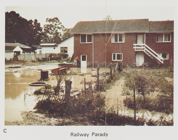
Work on paper (Sub-Item) - Photograph, Flooding, 75 Railway Parade, Eltham 8 April 1977
Colour photograph. Flooding of Diamond Creek at the rear and side of property at 75 Railway Parade, Eltham , 8 April 1977. flood, diamond creek, flooding, eltham, 75 railway parade -
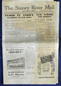
 Orbost & District Historical Society
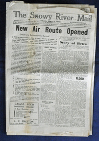
newspaper, Snowy River Mail, 29.3.1950
The Snowy River Mail is a weekly newspaper published in Orbost in the Shire of East Gippsland, Victoria, Australia. Previously published as The Snowy River mail and Tambo and Croajingolong gazette from 1890 to 1911. The Gippsland Courier merged with the Snowy River Mail when proprietor Lachlan Ross moved to Orbost in 1910. In 1999 the paper was acquired by the Yeates family when the Hollins family retired from the newspapers business. The paper is still being produced by the fourth generation of the Yeates family as part of East Gippsland Newspapers. The 1950 flood was a significant event in Orbost. This newspaper is a contemporary record of a significant local events.A Snowy River Mail newspaper dated 29.3.1950. It contains news articles and advertisements in black/white print. it contains an article on the flood at that time.snowy-river-mail 1950-flood newspaper -
 Orbost & District Historical Society
newspaper clippings, February 1971
These articles were compiled by Mary Gilbert who was the first curator of the Orbost Museum and a prominent historian / teacher in Orbost. The 1971 floods at Orbost were the worst on record. At Jarrahmond the river rose to a height of 11 metres and on the flats spread to one and a half kilometres wide. Considerable damage was done to railway infrastructure, roads and farms. More information from the APRIL, 2008 newsletter by John Phillips. (see orbosthistory.com.au)These articles are contemporary records of a significant historical event in Orbost.A manila folder containing black / white newspaper clippings from various publishers. They all relate to the 1971 floods in Orbost. (Details of contents in catalogue 735-900)floods-orbost-1971 -
 Kew Historical Society Inc
Photograph - Burgess House, Victoria Street (Abbotsford), 1880-1900
Major floods recurred of the Yarra River on a regular basis. A flood in 1901 destroyed this house in Victoria Street, Abbotsford. Later print copy of an original photograph. Home of C/N Burgess on the south side of Yarra River. The buildings were washed away in a flood in 1901 The house was in the same location as that on which Handley & Tilly was later built. This would locate it on the north side of Victoria Street, Abbotsford between Burnley Street and the Victoria Street Bridge. Photo shows three men and one woman working in an established garden in front of a weatherboard cottage."Home of C/N Burgess on south side of river; washed away in 1901; Handley & Tilly on site"yarra river -- floods, yarra river flood -- 1901, burgess family -- victoria street -- abbotsford (vic.) -
Port Melbourne Historical & Preservation Society
Photograph - Flooded subway at North Port Station, Port Melbourne, 14 Feb 1955
Item appeared on the front page 14.02.1955. In 2002 emails relating to this were received from Sweden, from the child standing in underpants only in the foreground. Image is used in the 2003 Historic Port Melbourne calendar.Lasercopy from original Herald photograph of railway sub-way at North Port Station on Raglan Street in flood, 14 February 1955, showing children from nearby houses swimming in the floodwaters near the underpass.transport - railways, flood, sport - swimming, advertising, business and traders - hotels, sandra svensson nilsson, robert (bobby) farrell, ruth 'bubbles' farrell -
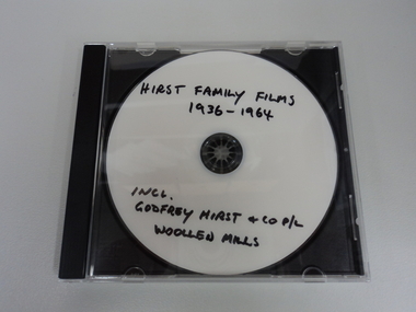 National Wool Museum
Film - Hirst Family Films, Cedric L Hirst, 1950s
Copy of Godfrey Hirst family videos/photograph on CD. Including 1951 floods at Mill. All video content filmed at Godfrey Hirst Woollen Mill, Swanston Street, South Geelong. Godfrey Hirst's children. Family home in Newtown and holiday home in Eastern View.Compact disc (CD) containing colour video footage. Film has no audio content. Visual content outlined below: 00:00 – 00:05 – External view of brick building – Godfrey Hirst & Co. Pty. Ltd. 00:05 – 00:10 – Exterior garden setting, three men in suits with fabrics and object 00:10 – 00:28 – Exterior garden setting showing eight women, most likely on a break from working at the Godfrey Hirst factory. The footage shows them all getting up and walking back towards the building at the end. 00:28 – 00:38 – Exterior garden setting, showing seven men in white shirts and ties seated and standing around a table, turning pages on a folder on the table. 00:38 – 00:52 – Interior factory setting, showing four men in coats handling green and red wool. 00:52 – 1:08 – Three men in suits in an exterior garden setting looking at paperwork. 1:08 – 1:23 – Four men in coats in a garden handling coloured wool samples. 1:23 – 1:42 – Four men in suits in a garden setting handling woven fabric. Two of the men are holding pipes. 1:42 – 1:57 – Interior factory setting showing men operating machinery. 1:57 – 2:05 – Exterior factory setting showing a man driving machinery carting wool bales. 2:05 – 3:14 - Flood scenes, showing the exterior of the Godfrey Hirst building with a man rowing a boat down the street, and a horse and cart in flood waters. There are scenes of flooded streets, exterior of flooded buildings and people standing in flood waters. 3:14 – 3:40 - Interior building views of flood waters in factory with people, machinery, equipment and textiles in flood waters. 3:40 – 4:03 - Exterior views showing a tractor, boat, horse and people in flood waters. 4:03 – 7:02 Exterior setting showing crowds of people watching a fashion parade. The fashion parade is of women in various clothing, including suits jackets, skirts, coats and hats. 7.02 - END"Hirst family films 1936-1964 Incl. Godfrey Hirst and co P/L Woollen mills"geelong, godfrey hirst & co. pty. ltd., family films, factory, flooding, 1950s, wool processing, fashion, textiles, horse and cart, wool bales, transport, machinery, fashion parade, working life -
 Orbost & District Historical Society
newspaper, 15.2.1950
The Snowy River Mail is a weekly newspaper published in Orbost in the Shire of East Gippsland, Victoria, Australia. Previously published as The Snowy River mail and Tambo and Croajingolong gazette from 1890 to 1911. The Gippsland Courier merged with the Snowy River Mail when proprietor Lachlan Ross moved to Orbost in 1910. In 1999 the paper was acquired by the Yeates family when the Hollins family retired from the newspapers business. The paper is still being produced by the fourth generation of the Yeates family as part of East Gippsland Newspapers. The flood in 1950 was a significant Orbost event. This newspaper is a contemporary record of a significant local events.A Snowy River Mail newspaper dated 15,.2.1950. It contains news articles and advertisements in black/white print. There is an artcle about the Orbost floods.newspaper snowy-river-mail flood-1950-orbost -
Glenelg Shire Council Cultural Collection
Slide - Glass Slide - Horses in a flood, n.d
Glass slide - horses in a flood -
 Melton City Libraries
Photograph, Melton Weir, 1970
Spillway, bridge and river in flood.misc. -
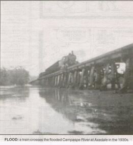 Bendigo Historical Society Inc.
Newspaper - JENNY FOLEY COLLECTION: FLOOD
Bendigo Advertiser "the way we were" from 1999. Flood: a train crosses the flooded Campaspe river at Axedale in the 1930s.newspaper, bendigo advertiser, the way we were -
 Eltham District Historical Society Inc
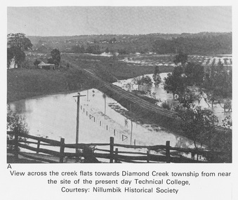
Work on paper (Sub-Item) - Photograph, View across the creek flats towards Diamond Creek township
Undated black and white photograph of view across the creek flats towards Diamond Creek township showing the railway line, with the Diamond Creek under flood. Situated behind the vicinity of Diamond Valley College, Main Hurstbridge Road, Diamond Creek. Diamond Valley College was formed in 1989 from the almagamation of Diamond Creek Technical School and Hurstbridge High School. Nillumbik Historical Society collectionflood, diamond creek, nillumbik historical society -
 Lakes Entrance Historical Society
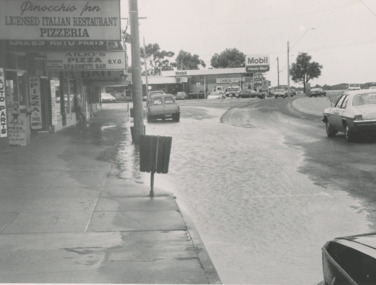
Photograph - Esplanade Lakes Entrance Victoria 1993, Lakes Post Newspaper, 1/09/1993 12:00:00 AM
Esplanade west of Myers Street intersection, businesses in photograph Pinochio Pizzaria, Lakes Auto Parts, Arjus Pizza, Bait and Tackle and Mobil Service Station on opposite corner Lakes Entrance Victoria. Flooding due to inadequate drainage, it soon went down.Black and white photograph showing flooding on Esplanade west of Myers Street intersection, businesses in photograph Pinochio Pizzaria, Lakes Auto Parts, Arjus Pizza, Bait and Tackle and Mobil Service Station on opposite corner Lakes Entrance Victoriabusiness, roads and streets -
 University of Melbourne, Burnley Campus Archives
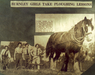
Photograph - Colour print, The Sun, Burnley Girls Take Ploughing Lessons, 1935
Photograph made by A.P. Winzenried as a possible illustration for, "Green Grows Our Garden." There was a severe flood in December 1934.2 copies colour print.. Copy of a newspaper article made by A.P. Winzenried. Caption reads, "Burnley Girls Take Ploughing Lessons. Winter tasks at the Burnley Horticultural School. Students trying their hands at the plough. New top soil had to be laid after the floods." 4 female students working with a horse drawn plough in the Orchard.Handwritten underneath, "R.Weber, E. Pearce, M. Younger, W. Wittakers. "The Sun" 12-6-35."a.p. winzenried, green grows our garden, ploughing lesson, female students, r.weber, e. pearce, m. younger, w. wittakers, orchard, 1934 flood, horse, working outside -
 Eltham District Historical Society Inc
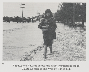
Work on paper (Sub-Item) - Photograph, Floodwaters flowing across Main Hurstbridge Road, Diamond Creek Township, 8 April 1977
Black and white photograph of young woman walking through floodwaters, possibly carrying an animal. The Diamond Creek in flood at Diamond Creek township, 8 April 1977 Herald and Weekly Times collectionflood, diamond creek, flooding, herald and weekly times, rescue -
Glenelg Shire Council Cultural Collection
Slide - Glass Slide - Glenelg River, n.d
Glass slide - Glenelg River in floodslide, photography, glenelg river -
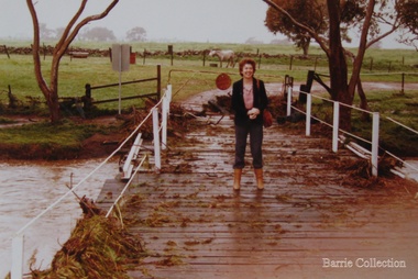 Melton City Libraries
Photograph, Wendy Barrie on the Darlingsford Bridge, 1983
Property of Lot 1 Thomas Bell Darling 1853 1863 Ralph Parkinson 1887 Sold to Richard Manning (Cr and Hotelier) leased by John Walsh Minns family lived at the house in the time of Welsh. C Parkinson died in Jan 1887 Ralph Parkinson was a prominent citizen of Melton and was known for his generosity, and his involvement in the community and the Church of England. He had one daughter, his wife and other daughter died earlier. He died in Jan 1887Photo was taken during the October floodslocal identities, landscapes of significance