Showing 1938 items
matching floods
-
 Kew Historical Society Inc
Postcard, R McGeehan, The Effect of Storm. Train Passing Through Flood Waters, South Yarra, 25-1-07, 1907
SHARP DOWNPOUR. ONE INCH IN 45 MINUTES. SOUTHERN SUBURBS DELUGED. TRAIN STOPPED AT SOUTH YARRA. One of the sudden downpours of rain which occasionally fall in Melbourne occurred yesterday afternoon, when nearly an inch of rain fell in the course of three quarters of an hour, and caused a flood for an hour or two in certain localities. During the early part of the day, the sky had been clouded over, but there was nothing to indicate a storm of such intensity as that which followed. At about half-past 1 o'clock residents of South Yarra, South Melbourne, Prahran, and St. Kilda noticed a few drops of rain. Still, it appeared unlikely that there would be anything exceptional, until with startling suddenness at about 10 minutes to 1 o'clock, one of the heaviest downpours within the memory of residents burst upon those suburbs. A strange feature of the storm was that it was practically confined to an area of about three miles square. The city was but little affected, though at a spot as close as the Observatory 86 points of rain were recorded in three-quarters of an hour. Thunder and lightning accompanied the downpour, which was cyclonic in character, the rain driving heavily from all points of the compass as the cyclone passed. It was in South Yarra and Prahran that the rain fell heaviest. Within a few minutes after it commenced, the low-lying portions of Toorak-road and practically the whole length of Chapel-street were under water. The depression at the intersection of Toorak-road and Darling-street speedily filled to the dimensions of a small lake. Several shops were inundated, while the water from the higher levels rushed down like a mountain torrent, and in several in-stances swept through the rear of houses and shops, carrying furniture in a floating mass against the further walls. In one case a footbridge was carried bodily away and dashed to pieces. Darling-street itself Great Davis-street, and other low-lying and flat thoroughfares in the vicinity became flooded from kerb to kerb, while on the other side of the railway-bridge the valley between Kensington-road and River-street became filled for some minutes to a depth of several feet. Meanwhile the waters from South Yarra hill, seeking a lower level, found it in the railway cutting, and the excavations from South Yarra station to Prahran on the one line, and to the Chapel-street bridge on the other, were converted into a couple of canals. At the platforms at South Yarra the water was two feet deep on the permanent way, and towards Hawksburn, at the sudden depression under Chapel-street bridge, it was at one time deep enough to cover a tall man's head. Into this swirling mass of water the 1:50 p.m. train from Oakleigh plunged on its way to Melbourne. The impact caused a mighty fountain of water to rise to a height of about 20 feet above the level of Chapel-street and send clouds of spray in all directions. Under the belief that a terrible explosion had occurred residents braved the rain and rushed to the spot, only to find that the train had been brought to a stand-still in the middle of what seemed to be a river. The water was so high that it had entered the fire-box from below, extinguishing the fires and cutting off the steam supply. In the meantime the officials at the South Yarra station had been preparing for emergencies. Inspectors were on duty at intervals along the line, and the moment the alarm was given an extra engine was backed carefully down and continued on to connect with the stranded train without losing its own power. There was a delay of about ten minutes in the service for an hour or two, but by 5 o'clock all the trains were running on time again, and the water had run off all but the spot beneath the Chapel-street bridge. Here the water remained about four feet deep until nightfall, and throughout the afternoon several hundreds of people including biograph operators and photographers, were gathered around watching each train pass through. Even with the water two feet lower, this was a work attended with considerable difficulty. Each train had to absolutely force its way through the weight of water, almost enveloped by the spray thrown up, and it was only just able to negotiate the "ford" by using every ounce of steam. ... The Argus, 26 January 1907, p19.The item forms part of the Laurie Bennett collection of thirty-six postcards and photographs of Kew and early Melbourne, donated to the Kew Historical Society in 1980. The postcards in the Bennett collection, like other images in the Society's holdings date from the 1890s to the present and comprehensively indicate points-of-view or scenes considered historically, aesthetically or socially significant in the period in which they were produced.Postcard depicting a flood at South Yarra Station in 1907. The title and photographer's name are identified on the front of the postcard. Donated by L. Bennett, 1980flood - south yarra, trains - melbourne, postcards, r mcgeehan - prahran -
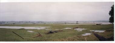 Orbost & District Historical Society
coloured photographs, Hogeman, Trudi, 2000 - 2010
These photographs are of floodwaters on the river flats of Orbost, near Gilberts Gulch on the Marlo Road showing large lumps of wood in the middle of the road and a red vehicle in the background. 3090.4 has been taken looking down onto theSnowy Rive from near Mitchells / Griebenows Road Newmerella.This is a pictorial record of a significant flood event in Orbost.Four panoramic colour photographs showing the aftermath of a flood. flood-orbost-2000s -
 Ballarat Heritage Services
Photograph - Colour, Flood recovery, Carisbrook
Colour photograph damaged during floods at Carsibrook, Victoria. carisbrook flood, disaster recovery -
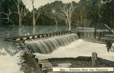 Stawell Historical Society Inc
Postcard, Wimmera River Weir at Glenorchy -- Postcard
Wimmera River Weir Glenorchy with letter written on card and 1d stamp.Coloured post card of a weir along a flooded river. Wier-Wimmera River near Glenorchy addressed to Mrs. G. Wood Hill View Stawell. Message from Oliver dated 8/6/10 plus stamp.water -
 Chelsea & District Historical Society Inc
Photograph - Chelsea Flood December 1934
In December 1934, 700 houses were inundated with water, when the Dandenong Creek and Patterson River broke their banks.Two Black and white photo of flood waters in Chelsea. flood, chelsea, dandenong creek, nepean highway, point nepean road -
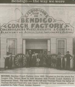 Bendigo Historical Society Inc.
Newspaper - JENNY FOLEY COLLECTION: MOVING, 2000
Bendigo Advertiser ''The way we were'' from 2000. Moving: Bendigo Coach Factory circa 1890. Situated on the site where the Dragon City Tenpin Bowl is now situated was Floods Coach Builders in Hargreaves street. The man fifth on the left was Thomas Flood, the father of Thomas Richard Flood who was mayor of Bendigo on four occasions. (Photo supplied by Peter Flood, Golden Square). The clip is a folder.newspaper, bendigo advertiser, the way we were -
 University of Melbourne, Burnley Campus Archives
Newspaper - Newspaper Cutting, The Leader, Horticultural Notes, 1891
... floods ...Copy of article in "The Leader" (Melbourne) on 22 August, 1891 p 14. Descriptions of members of the Board of Advice for the School of Horticulture and curriculum. Discussion about what to do to prevent further flood damage such as a breakwater. Mr Neilson, curator, has managed to save the young apple trees.the leader, mr neilson, curator, apple trees, school of horticulture, floods, board of advice, flood damage -
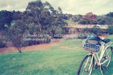 Eltham District Historical Society Inc
Photograph, Fay Bridge, Diamond Creek in flood at the Bridge Street Bridge, Eltham, c.2004
... floods ...View looking southeast from Alistair Knox Park (west). The Diamond Creek Trail footbridge is completely submerged. Significant flood events occurred Nov-Dec 2004 and Jan-Feb 2005.fay bridge collection, 2004, bridge street bridge, diamond creek (creek), floods, floodwater -
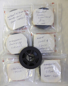 Warrnambool and District Historical Society Inc.
Film - Films, Eight reels of 8 mm film, Various mid to late 20th century
These films depict local scenes such as Childers Cove, Warrnambool Breakwater, Thunderpoint and Port Campbell. The other films depict events such as the 1974 Merri Flood and the demolition of the Woollen Mill chimney All these films provide historical, artistic and social views of the district. Eight reels of 8 mm film depicting local scenes and events. Most are shot in colour.Warrnambool events and locations. Wangoom Primary School (4 reels) Flooded Merri Woodford 1974 (1 reel) Warrnambool Breakwater, Thunderpoint, Port Campbell(1 reel) Childers Cove(1 reel) Woollen Mill Chimney Demolition(1 reel)warrnambool, childers cove, 1974 merri flood, warrnambool woollen mill -
 Kew Historical Society Inc
Photograph, Burke Road Bridge, 1930s
Without bridges, Kew remained cut off from the City of Melbourne, only being accessible by Punt. Private and public bridges were constructed from the 1850s, beginning with the Hawthorn Bridge linking Bridge and Burwood Roads. A bridge across the Yarra at Burke Road was created as early as 1873. Since that first wooden bridge, a number of later bridges, typically on concrete pylons have been built, in 1926 and again during the 1970s.Sepia, faded photograph of the Burke Road Bridge linking East Kew and Ivanhoe. The previous bridge, constructed in 1926 was submerged beneath the flood waters in the 1934 mega-flood of the Yarra.burke road bridge (kew), bridges -- river yarra -
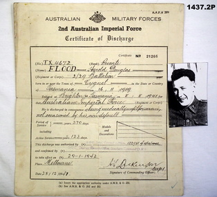 Bendigo Military Museum
Administrative record - CERTIFICATE OF DISCHARGE WW2, 28.12.1941
.1) Discharge Certificate No 21266 re TX4672 Pte Flood, Harold Douglas 2/29 Battalion, POB Cygnet Tasmania .2) Poor quality photo of Pte Flood.documents, discharge certificate, photos, flood -
University of Melbourne, Burnley Campus Archives
Newspaper - Newspaper Cutting, The South Bourke Standard, The Horticultural Society, 1864
... floods ...Cop[y of article in "The South Bourke Standard" 29 July, 1864 p3. Description of the Annual Meeting of the Society. The December flood had destroyed the fruit tree plantings. The Government had refused a request to grant them more suitable land to the north so part of the ornamental section had to be broken up and planted with fruit trees.the south bourke standard, floods, ornamental garden broken up, fruit trees, fruit trees destroyed, refusal of government funding, government funding -
Glenelg Shire Council Cultural Collection
Photograph - Photograph - Casterton Flooding, c. 1946
SOURCED FROM CASTERTON TOWN HALL (FORMER SHIRE OF GLENELG) Sourced from Casterton Town Hall (Former Shire of Glenelg)Black and white photo of 1946 floods at Casterton, bridge with carBack: Purple photographer's stamp -
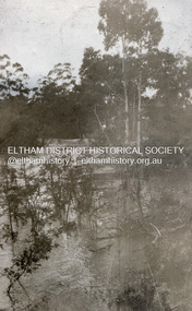 Eltham District Historical Society Inc
Photograph, Flood at Eltham, c.1924
... floods ...Probably the 1924 flood which damaged the Main Road Bridge Pages from a scrapbook belonging to Heather Jenkins (nee Sargeant) who lived as a child in the Police Residence at 728 Main Road, Eltham in the 1920s.Heather Sargeant was the daughter of Constable W.C. Sargeant, the local police officer in residence at Eltham, 1922-1927Glued on a brown paper scrapbook page (torn from scrapbook) with 8 black and white/sepia photos of varying sizes, 1 newspaper clipping and one greeting card with printed sketch and handwritten captions in ink. On back of page is 1 black and white photo and a large newspaper clipping.eltham, police residence, heather jenkins (nee sargeant), walter withers, constable w.c. sargeant, floods -
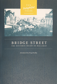 Federation University Historical Collection
Booklet, Doug Bradby, Bridge Street: The Historic Heart of Ballarat, 2020
... floods ...Twenty eight page dark green covered book on Ballarat's Bridge Street, including information on the Gravel Pits, Main Road shops, floods, Chinese cerneval, Queen carneval, Yarrowee Bridge, Eureka Stockade, fire, Yarrowee Creek.non-fictionballarat, gravel pits, main road shops, floods, chinese cerneval, queen carneval, yarrowee bridge, eureka stockade, fire, yarrowee creek, bridge street -
Clunes Museum
Document - DOCUMENTS, 13/14 JANUARY 2011
.1 2 PAGE TYPED LETTER TO CLUNES FIRE BRIGADE FROM GRAEME JOHNSTONE RE CLUNES FLOOD ON 13/14 JANUARY 2011 .2 TYPED EYE WITNESS ACCOUNT OF EXTREME WEATHER ON 13/14 JANUARY 2011 BY ANDREW JOHNSTONE .3 11 A4 PRINTED PHOTOGRAPHIC ENLARGEMENTS SHOWING CLUNES FLOOD AND FLOOD DAMAGE 13/14 JANUARY 2011 .4 ONE PHOTOGRAPH OF FLOODS IN CLUNES JANUARY 2011clunes flood 2011, clunes fire brigade, graeme johnstone, andrew johnstone -
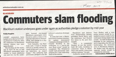 Whitehorse Historical Society Inc.
Article, Commuters slam flooding, 2017
The underpass at Blackburn railway station flooded again on the morning of Apr 26th preventing passengers from boarding city bound trains. This is the fifth time it has flooded in the past 4 months.level crossing removal authority, blackburn railway station -
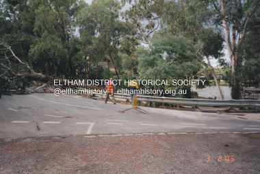 Eltham District Historical Society Inc
Photograph, Fay Bridge, Diamond Creek in flood, Eltham, 3 February 2005
... floods ...Significant flood events occurred Nov-Dec 2004 and Jan-Feb 2005.fay bridge collection, bridge street bridge, diamond creek (creek), floods, floodwater, footbridge, main road bridge, susan street oval, diamond street, eltham -
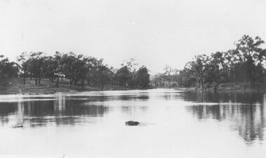 Ringwood and District Historical Society
Photograph, Ringwood Lake in flood - 1950
Typed below photograph, "Ringwood Lake in flood - 1950" -
 Ringwood and District Historical Society
Photograph, Warrandyte flooded coffer dam(undated)
Catalogue card reads, "Warrandyte flooded coffer dam" -
 Bendigo Historical Society Inc.
Newspaper - LYDIA CHANCELLOR COLLECTION; MAYOR SPEAKS
A small green and white box containing cuttings from the Bendigo Advertiser dated 1968, 1969 titled, ' Mayor Speaks.' It relates to the Bendigo City Council's activities over the two years.Mayor T. Flood Speaks out 1968-9newspaper, bendigo advertiser, newspaper column, lydia chancellor, collections, newspaper, newspaper column -
 Bendigo Military Museum
Pamphlet - COMMEMORATIVE PLAQUE 1997, C.1997
The Tom Flood Sports Centre was originally called The Bendigo Show Grounds. This plaque was unveiled by the City of Greater Bendigo & the Bendigo RSL Sub Branch to Commemorated the venue as a "Training Camp" during WW2. Order of Service was, Welcome, Mr Alan Holmes (President Bendigo RSL) Introduction of Recruits & Others associated with the Camp. A brief history of the Camp and Anecdotes was read by Mr Alan Holmes. Presentation and unveiling of the Plaque by Cr Barry Ackerman, Mayor City of Greater Bendigo. The wording: "Commemorating this site as an Australian Imperial Force Training Camp during WW2. "To the following Corps we pay Tribute" "10th AIF Training Depot" "Australian Army Medical Corps" "Australian Army Ordnance Corps" "Australian Army Service Corp". "Australian Electrical and Mechanical Engineers" Prayer of Thanksgiving & Commemoration by; Rev J. South. This was followed the "ODE, Last Post, One minutes Silence, Reveille and The National Anthem. As far as records available the Camp was first set up on 17.6.1940 with an Advance Party. The last Troops left there on 30.4.1943 for Ingleburn NSW, the Camp was vacated in May 1943. Pamphlet white paper, A4 folded making 4 pages, all print in black.On the front, "This Commemorative Plaque was unveiled at the Tom Flood Sports Centre Park Road Bendigo Sunday 27th April 1997"brsl, smirsl, plaque, tom flood, training camp -
 Bendigo Historical Society Inc.
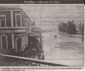
Newspaper - JENNY FOLEY COLLECTION: FLOODED
Bendigo Advertiser "way we were" from 1999. Flooded: looking towrd High Street from the Shamrock Hotel, the picture shows Pall Mall in flood after the rains in February 1871.newspaper, bendigo advertiser, the way we were -
University of Melbourne, Burnley Campus Archives
Newspaper - Newspaper Cutting, The Leader, Horticultural Notes, 1891
Copy of article in "The Leader" (Melbourne) on 18 July, 1891 p14. Description of damage the recent flood had done to the Horticultural Gardens. Deemed to have done more damage than the 1863 flood.the leader, horticultural gardens, flood, damage to gardens -
Clunes Museum
Photograph
COPY OF PHOTOGRAPH OF FLOOD ON CRESWICK CREEK AT SUSPENSION BRIDGE BEHIND KEEBLE'S 8/9/1909 TALBOT RD CLUNES. IT WAS THIS BRIDGE THAT MR. WATSON WAS SO NEARLY CARRIED DOWN WITH THE RUSHING WATERS. HE WAS STANDING ON PART OF IT, WHEN IT BROKE AWAY AND HE MANAGED TO CLING TO TO THE REMAINSsuspension bridge flood, flood creswick creek, 1909 flood -
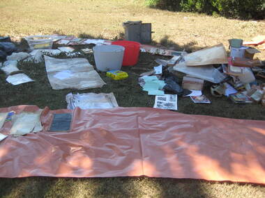 Ballarat Heritage Services
Photograph - Colour, Flood recovery, Carisbrook, 40 degree heat
Colour photographs of paperbased items being 'recovered' after the Carisbrook floods.carisbrook, flood, flood recovery -
 Orbost & District Historical Society
black and white photograph, mid 1930s
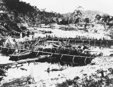
This is a photograph of McKillop's Bridge probably taken just after its rebuilding. The current McKillop’s Bridge was built by the Country Roads Board in two stages between 1931-36, during which its height was raised after the original bridge superstructure was washed away in record floods of January 1934, prior to its original official opening. In its reconstructed form the original concrete abutments were turned into additional piers and the welded-steel trusses were cantilevered back over them to meet the new higher road approaches. "McKillops Bridge was Heritage listed due to its social and technological significance – the steel trusses' arc-welded construction technique was a pretty big deal in the 1930s. It was once an important route for cattlemen, who used the ford across the Snowy in the years preceding the bridge's existence"This is a pictorial record of McKillop's Bridge just after its construction.A black / white photograph of a wooden bridge across a river. At the bottom right is a man with his back to the camera. He is looking at flood debris on the bank. At the bottom left are two men near a pylon.on back - McKillops Bridgebridge-mckillop's snowy-river-bridge -
Glenelg Shire Council Cultural Collection
Postcard, c. 1946
Sourced from Casterton Town Hall former Shire of GlenelgBlack and white photo/postcard, showing ? Island Park Casterton during 1946 flood. Tractor in flooded yard near shed. Tin back fence with 'The World's Favourite' written on it. (Rest of advertisement underwater)Back: Purple photographer's stamp. 'Postcard' - purple -
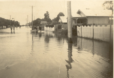
 Chelsea & District Historical Society Inc
Photograph - Chelsea Flood December 1934, Wells Road, Chelsea
In December 1934, 700 houses were inundated with water, when the Dandenong Creek and Patterson River broke their banks.Three Black and white photo of flood waters across Wells Road, Chelsea. A SEC truck can be see travelling down Wells Road in photo one and two, with people viewing the flooded street.flood, chelsea, dandenong creek, nepean highway, point nepean road -
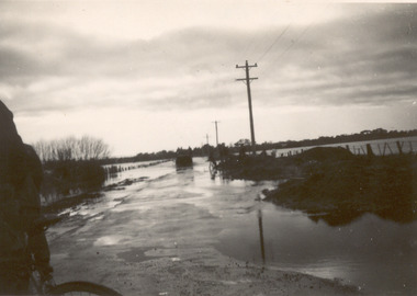
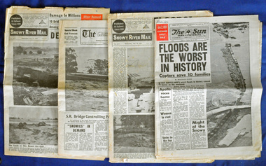 Orbost & District Historical Society
newspapers, February 1971
The 1971 floods at Orbost were the worst on record. At Jarrahmond the river rose to a height of 11 metres and on the flats spread to one and a half kilometres wide. Considerable damage was done to railway infrastructure, roads and farms. More information from the APRIL, 2008 newsletter by John Phillips. (see orbosthistory.com.au)These newspapers are contemporary records of a significant local event.Four newspapers and a set of clippings from various papers. They contain information and photographs pertaining to the 1971 floods in Orbost. 2557.1 is a Sun News Pictorial dated 8.2.1971. 2557.2 is a Snowy River Mail dated 10.2.1971. 2557.3 is an east Gippsland News dated 12.2.1971. 2557.4 is a Snowy River mail dated 12.2.1971 and 2557.5 is a collection of various clippings.floods-orbost-1971 newspaper snowy-river-mail sun-news-pictorial